

Share

Scan the QR code and open PeakVisor on your phone
Scan the QR code and open PeakVisor on your phone
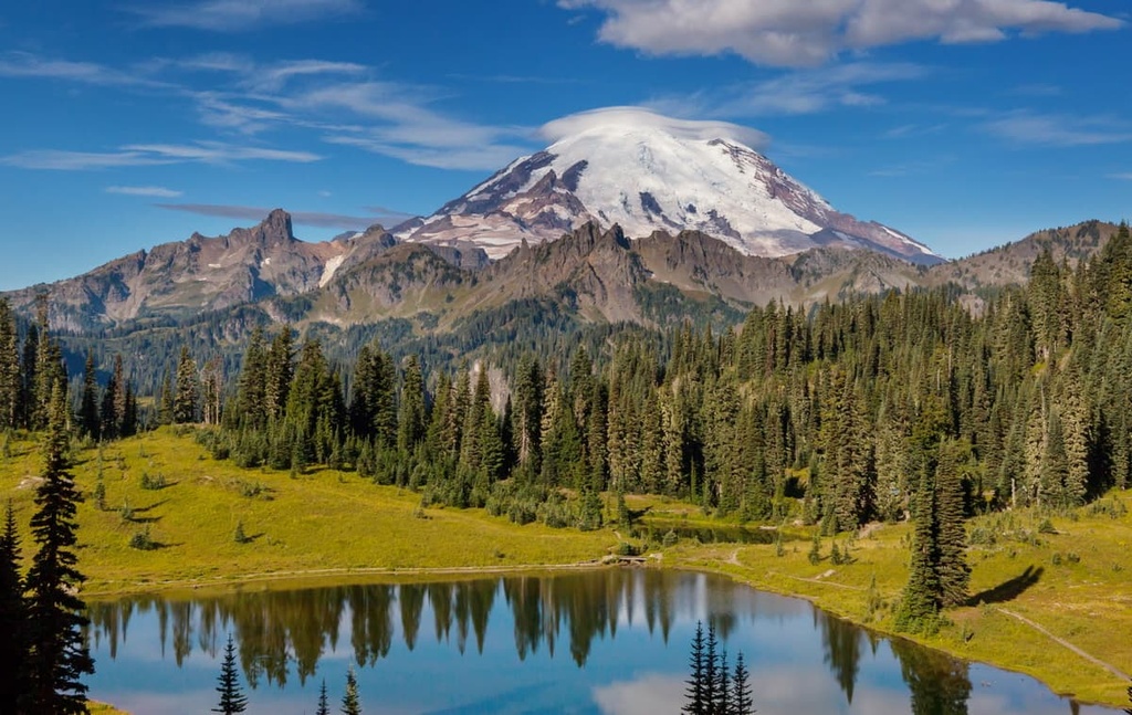
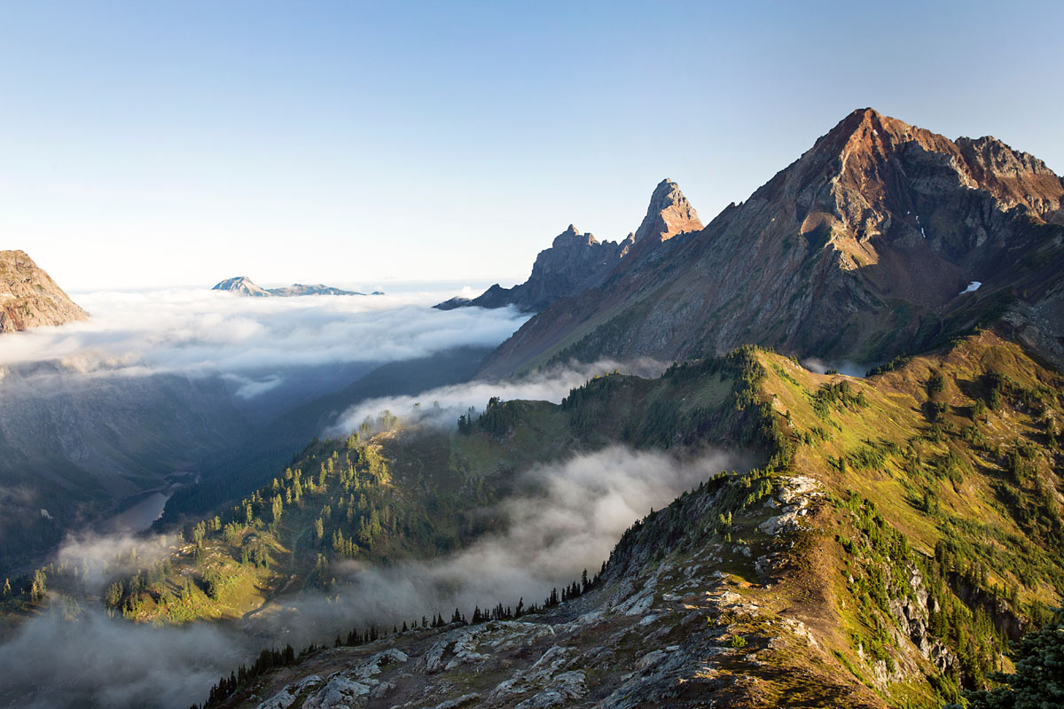
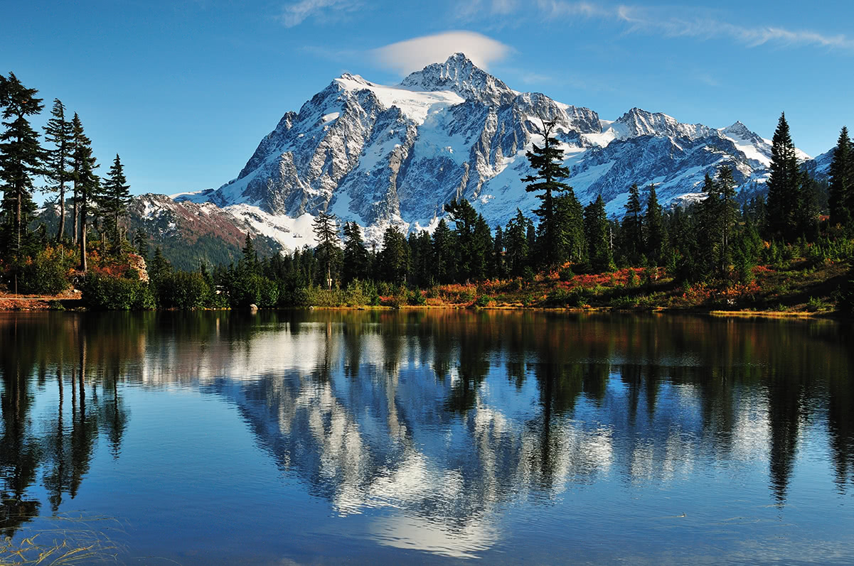
Known for its snow-capped peaks, vast glaciers, rocky scree slopes, and dense forests, the Cascade Range is a major collection of mountains located in the Pacific Northwest region of the northwestern US and southwestern Canada. The range contains 4375 named mountains, the highest and most prominent of which is the mighty Mount Rainier (14,409 ft/4,392 m).
The Cascade Range (more commonly referred to as just ‘the Cascades’) is one of the major mountain ranges in the western United States. In total, the range extends for some 700 mi (1,100 km) from north to south and is upward of 80 mi (130 km) wide at its widest point.
Most sources pinpoint the southern terminus of the Cascades as Lassen Peak, which is a lava dome that’s located in northern California. The range then stretches northward through Oregon and Washington until its terminus, which is located at the confluence of the Thompson and Nicola rivers in the southern part of the Canadian province of British Columbia.

For the most part, the Cascade Range coincides with the southern and central part of the Cascade Volcanic Arc, which includes the volcanoes that formed as a result of the Cascadia subduction zone.
The Cascades are one of the most rugged mountain ranges in the northwestern US. Their proximity to the Pacific Ocean and the fact that the region has prevailing westerly winds is also one of the reasons why the range receives so much snow and rain each year. In fact, some of the peaks in the Cascades, such as Mount Baker, are known to receive dozens of feet of snow each winter.
That said, the Cascades are far from the only mountain range in the region. In fact, the range is surrounded by mountain ranges and plateaus on nearly all sides.
For example, the Cascades are located to the east of the Pacific Coast Ranges (Northwest US Coast Ranges), which include the Olympic Mountains, Klamath Mountains, and the Pacific Ranges. They are also situated to the west and northwest of the Columbia Mountains, Columbia Plateau, Sierra Nevada, and Great Basin Ranges as well as to the south and southwest of the British Columbia Interior and the Canadian Rockies.
The Cascades encompass part of three US states and one Canadian province: California, Oregon, Washington, and British Columbia.
In California, the range is located in Shasta, Lassen, and Siskiyou counties, and in Oregon, the range is part of Jackson, Klamath, Douglas, Lane, Deschutes, Jefferson, Linn, Marion, Wasco, Clackamas, Hood River, Wasco, and Multnomah counties.
The Washington section of the range is situated in Skamania, Clark, Cowlitz, Lewis, Pierce, Thurston, King, Snohomish, Skagit, and Whatcom counties while the British Columbia portion of the Cascades is located in the Fraser Valley, Okanagan-Similkameen, and Squamish-Lillooet regional districts.
The Cascade Range is a particularly interesting range from a geologic perspective as it is home to a number of active volcanoes
These volcanoes are part of a greater volcanic region called the Cascade Volcanic Arc, which itself is a part of the Ring of Fire. The Ring of Fire is a system of volcanoes that extends around much of the rim of the Pacific Ocean.

It includes peaks that run down the western coast of the Americas from the volcanoes of the Aleutians in Alaska to those of the Andes in Chile. The Ring of Fire also extends across the eastern edge of Asia and Oceania as it includes peaks found through the Pacific Islands (such as those in Fiji, Samoa, and Tonga) as well as the volcanoes in Indonesia, Japan, and the Philippines.
The Ring of Fire is a result of the subduction that occurs along most of the margins of the tectonic plates that underlie the Pacific Ocean. In the case of the Cascades, the Juan de Fuca Plate, which is located at the edge of the Pacific Ocean in this area, is subducting (being pushed down below) under the North American Plate.
As a result of this subduction, magma from the lower portion of the Earth’s crust and the upper part of the mantle is pushed upward toward the surface where it creates volcanic activity, such as what we see throughout the Cascades to this day.
The Cascade Volcanic Arc has been volcanically active for around 37 million years and it continues to be active to this day. However, although each of the volcanoes in the range is geologically linked to the subduction of the Juan de Fuca Plate, they each have their own volcanic histories and some are considered by volcanologists to be more active than others.
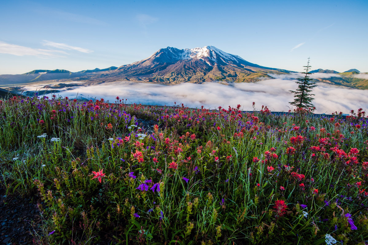
For example, two of the most notable major eruptions of recent centuries include the 1980 eruption of Mount Saint Helens and the 1914–1917 eruption of Lassen Peak. Geologic evidence also suggests that Mount Meager erupted around 400 BCE and that Mount Mazama erupted around 5750 BCE. Researchers also believe that Glacier Peak erupted sometime around 11,150 BCE.
Due to the fact that many of the volcanoes in the Cascades are both volcanically active and located close to a number of major metropolitan areas, some of the volcanoes in the range are considered to be among the most dangerous in the world.
The US Geological Survey (USGS) operates the Cascades Volcano Observatory to keep track of any early warning signs of volcanic activity in the region. According to the USGS, the volcanoes with the highest threat potential are Crater Lake, Glacier Peak, Mount Baker, Mount Hood, Mount Rainier, Mount St. Helens, Newberry, and the Three Sisters.
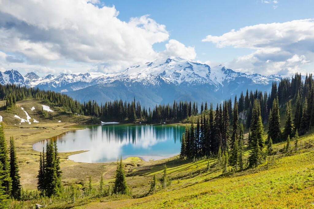
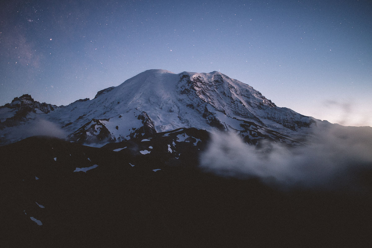
It’s also worth mentioning that the Cascades are one of the most heavily glaciated mountain ranges in the contiguous United States. Most of the range’s major landforms have been carved out by glaciers over the course of millennia and the majority of the highest peaks in the Cascades are covered in glaciers, including Mount Baker, Mount Rainier, and Glacier Peak.
Unlike many other major mountain ranges in the US and Canada, the Cascades don’t have a particularly large quantity of named subranges. There certainly are named subranges within the Cascades, though they are smaller in number than, say, the dozens of named subranges of the Pacific Ranges.
Most people will make a distinction between the Cascades as a whole and the North Cascades, which is the section of the range that’s located in Washington and British Columbia. Some people refer to the northernmost part of the range as the Canadian Cascades, too.
Some of the notable subranges within the North Cascades include:
The Cascades are home to some of the most iconic mountains in the United States. Many of the highest peaks in the range are particularly prominent and many of the major peaks are heavily glaciated.
Some of the most notable peaks in the Cascades include:


The Cascades have an interesting ecology as the flora and fauna found in the range vary as you move from south to north.
Overall, the Cascades are one of the wettest major mountain ranges in the western US as they receive a substantial amount of rain during the summer and a sizable amount of snow in the winter months. The amount of rainfall in the range does vary depending on your specific location; however, the Cascades’ proximity to the coast brings a particularly large amount of precipitation to its western slopes.
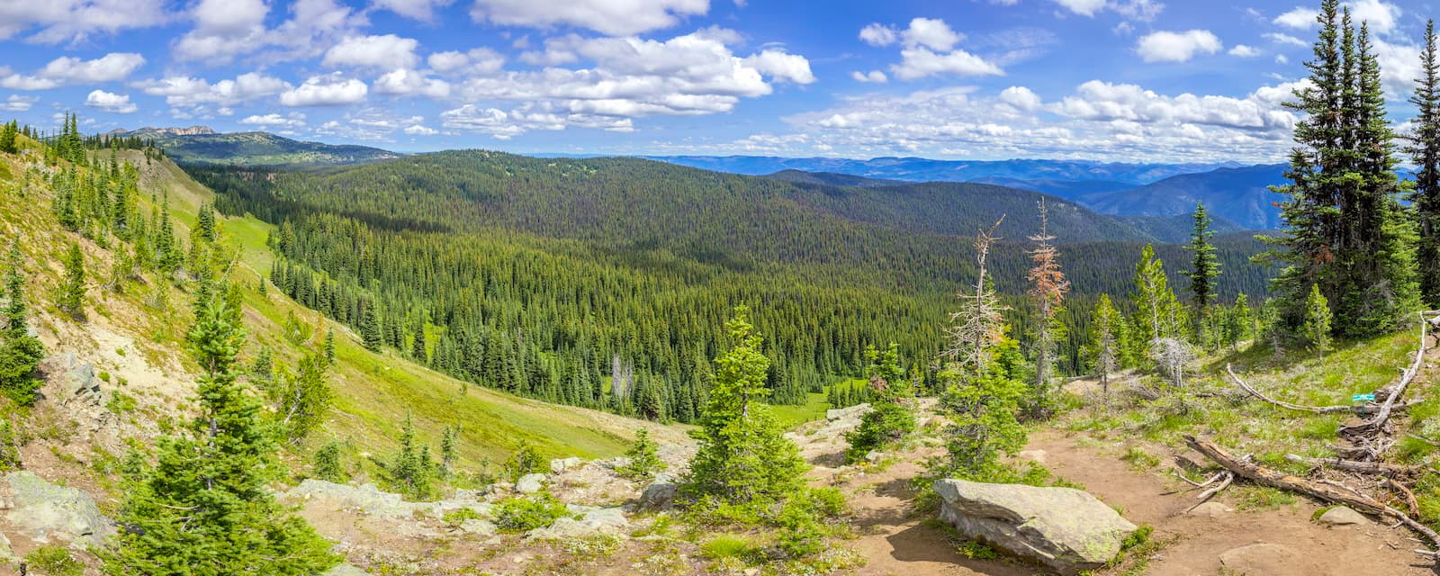
The tree species found in the range include everything from western red cedars and western hemlocks to Douglas firs, subalpine firs, mountain hemlocks, grand fir, Pacific silver fir, and Alaska yellow-cedar. The timberland in the range changes depending on your specific location but it can be as low as 6,000 feet (1,800 m) in places.
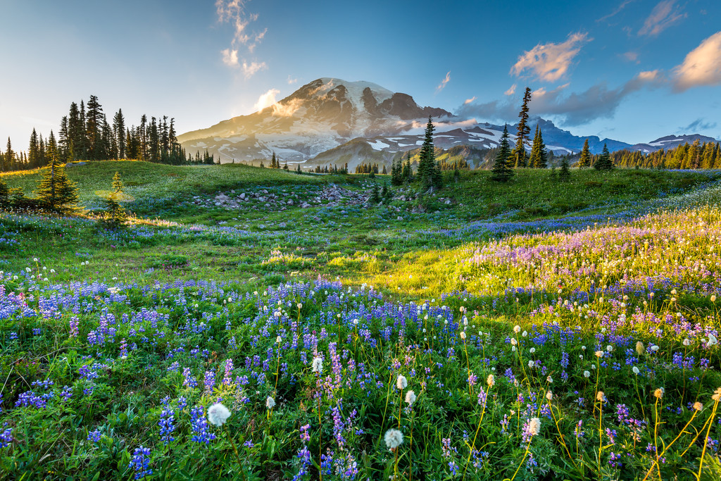
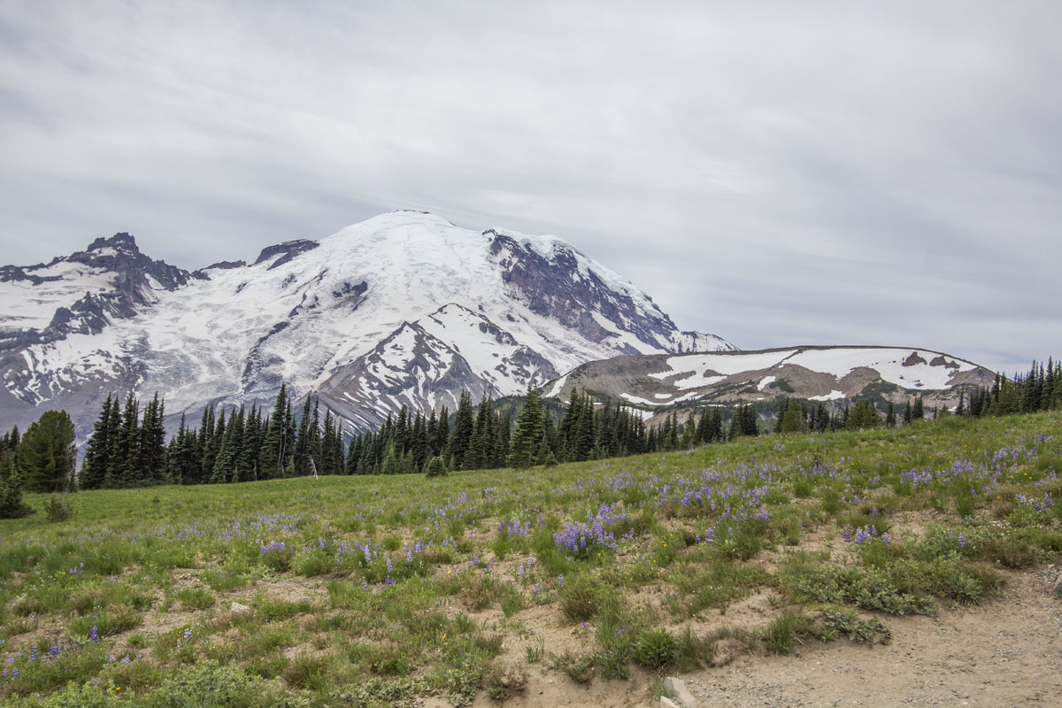
Above the timberline, the Cascades are home to some of the most stunning alpine meadows in the region. Here, grasses, low-lying shrubs, and wildflowers dominate the landscape. You can find a wide range of wildflowers in the range, such as tiger lilies, columbines, valerians, bluebells, lupines, mountain bog gentians, and monkshoods.
As far as wildlife goes, the Cascades provide the perfect habitat for a range of notable species. This includes black bears, grizzly bears, mountain goats, bobcats, coyotes, mountain lions, moose, deer, elk, beavers, and even gray wolves. You can also find marmots, pikas, and ptarmigans in the alpine regions of the range.
The range's waterways also provide the ideal habitat for many fish species. This includes bull trout, rainbow trout, cutthroat trout, golden trout, lake trout, largemouth bass, smallmouth bass, kokanee, burbot, and steelhead.
Technically, the Skagit River Watershed is home to all five species of Pacific salmon (coho, chinook, pink, chum, and sockeye). As a result of all of these fish species, the Cascades are also a particularly good place to go bird watching. If you’re lucky, you can even spot bald eagles fishing for salmon in the range’s many rivers.
The land in and around what is now called the Cascade Range has been home to humans since time immemorial.
Many Tribes and First Nations consider the region to be part of their ancestral homelands, including the Confederated Tribes of Warm Springs, Yakama Nation, Muckleshoot Indian Tribe, Tulalip Tribes, Swinomish Indian Tribal Council, Lummi Nation, and Colville Tribes.
The northern part of the region is also part of the traditional territory of the Soowahlie, Tzeachten, Yakweakwioose, Skowkale, Popkum, Cheam, Peters, Spuzzum, Yale, Upper Similkameen, Lower Similkameen, Coldwater, Lower Nicola, Nooaitch, Shackan, Nicomen, Union Bar, Skawahlook, and Shxw'ow'hamel First Nations, among many others.
Many of the volcanoes in the Cascades play prominent roles in the creation stories of many of the Tribes and First Nations with ancestral ties to the region. The abundance of fish and game to hunt in the Cascades as well as the plethora of edible berries and plants in the range have made the region an attractive place for humans to live for thousands of years.

The first peoples of European descent to visit the region included a number of notable British sailors and navigators such as Captain James Cook and Captain George Vancouver. Cook sailed up to the area around Nootka Sound on what’s now called Vancouver Island in 1778. While he did not visit the Cascades, in particular, he did sail along the region’s rugged coastline.
George Vancouver came to the region in 1792 on his voyage along the Pacific Coast of North America. During this voyage, Vancouver sailed into what’s now called the Puget Sound near modern-day Seattle and gave English-language names to many of the major peaks that you can see from the water (these peaks, of course, already had names in the region’s many Indigenous languages).
In particular, Vancouver named Mount Baker for his third lieutenant, Joseph Baker. However, it had previously been named La Gran Montaña del Carmelo by Spanish-Peruvian sailor Manuel Quimper in 1790 during his voyage around the San Juan Islands and the Olympic Peninsula. Quimper’s influence is one of the reasons why there are many Spanish-language place names in the region.
Vancouver also named Mount Rainier after Royal Navy Admiral Peter Rainier. Additionally, Vancouver sent one of his lieutenants, William Robert Broughton, to travel around the lower Columbia River Valley. During this time, Broughton coined a number of other English language names for the region’s peaks, including Mount Hood (for Lord Samuel Hood) and Mount St. Helens (for Alleyne FitzHerbert, 1st Baron St Helens).

European settlement of the region didn’t really occur in full force until the nineteenth century. Although fur trappers and fishermen of European descent invariably traveled around the region during the eighteenth century, the real start of colonization of the region began after the arrival of the Lewis and Clark Expedition.
Lewis and Clark made it to the Columbia River after passing through the Cascades in 1805. In the years that followed, many settlers also made their way to the region. Many of these early settlers came to the area in the hopes of establishing farms or in finding opportunities for fur trading, logging, or mining, and they pushed out the Tribes and First Nations living in the region in the process.
One of the earliest known uses of the name ‘Cascade Range’ also occurred during this time. The name ‘Cascades’ is thought to be a reference to the Cascades Rapids, which are located in the Columbia River Gorge but are now submerged below the Bonneville Reservoir.
These rapids were one of the last obstacles that settlers traveling westward had to pass to reach the coast, so they often referred to the mountains surrounding the rapids as ‘the mountains by the cascades.’ The botanist David Douglas referred to the peaks solely as the ‘Cascade Range’ in 1825. He is often cited as the person who coined the term though it may have been in common use in earlier years.
During the early nineteenth century, the region also became a popular destination for fur traders. The Hudson’s Bay Company established a trading post near what is now Portland, Oregon, which helped to grow the industry in the region.

That said, the establishment of the Oregon Trail was the real start of European settlement of the region as the trail made travel to the area much easier. Around this same time, the Canadian portion of the range experienced a gold rush in the Fraser Canyon. The creation of the Canadian Pacific Railway also helped to improve travel in the northernmost part of the range.
The states that contain the Cascades (California, Oregon, and Washington) were all admitted to the United States in the mid- to late-nineteenth century. British Columbia also joined the Canadian Confederation in 1871.
Improved transportation connections, mostly by the way of trans-continental train lines and highways, helped to connect the settlements in the Cascades region to the major population centers in the eastern parts of the US and Canada.
Over time, many of the cities in the Cascades grew to become major metropolitan areas as more people moved out west in hopes of becoming successful in one of a number of growing industries in the region, such as mining and logging.
Nowadays, the range’s major cities are popular tourist destinations in their own right as they offer a plethora of urban activities for visitors to enjoy. Much of the Cascades is also protected at either the state, provincial, or federal level, so it’s one of the best places to hike, climb, and ski in the US and Canada.

Due to its size, ruggedness, incredible beauty, and ample opportunities for outdoor recreation, the Cascade Range is home to dozens of protected areas. Most of these protected areas allow for recreational use, such as hiking, climbing, and skiing.
Here’s a quick look at some of the different protected areas in the range so you can start planning your next adventure to the region.
The Cascade Range is home to four national parks, namely:
As is the case with all national parks, the parks in the Cascades are managed by the US National Park Service, which is an agency of the US Department of the Interior. Their mandate is to preserve and protect the natural and cultural resources of these parks for the enjoyment and education of current and future generations.
In the Cascades, the national parks offer some of the best hiking and mountaineering opportunities in the region, though they also tend to be some of the busiest destinations in the range.
In addition to national parks, there are many national forests found within the Cascade Range. These include:
National forests in the US are administered by the aptly named US National Forest Service, which is an agency of the Department of Agriculture. National forests are considered the “land of many uses,” so they allow for everything from outdoor recreation and wildlife management to mining, timber harvesting, and grazing, depending on the specific forest’s management plan.
In the Cascades, the emphasis in many of these national forests is on outdoor recreation. However, trails tend to be less well-maintained in many of the more remote parts of these national forests. Logging and other resource extraction activities are also allowed in some areas. But if you’re looking to get off the beaten path, national forests are a great option.
National monuments are protected areas that can be created by Congress or by the US President through the Antiquities Act. They can be administered by a number of different agencies, though most land-based monuments are managed by the National Park Service, US Forest Service, US Fish and Wildlife Service, and the Bureau of Land Management.
Some of the major national monuments located in the Cascades include:
Wilderness areas are federally designated protected areas. They are protected under the 1964 Wilderness Act and they are part of the National Wilderness Preservation System.
Wilderness areas can be managed by any of four agencies: National Park Service, US Forest Service, US Fish and Wildlife, and the Bureau of Land Management. These areas hold some of the highest levels of protection of any outdoor recreation destination in the US as they do not allow for resource extraction or motorized/mechanized travel.
There are dozens of wilderness areas in the Cascade Range. In California, these wilderness areas include:
Some of the wilderness areas in the Oregon section of the Cascades include:
Finally, the Washington section of the Cascades is home to the following wilderness areas:
The northernmost extent of the Cascade Range crosses the international border from the United States into Canada. In the British Columbia section of the range, there are a number of provincial parks, which are provincially protected recreation areas that are managed by BC Parks.
Some of the provincial parks in the Cascades include:
Hiking is one of the best ways to experience the true beauty of the Cascade Range. There are thousands of miles of hiking trails in the range and dozens of protected areas, so we can’t possibly discuss them all here.
However, we’ve put together a brief guide to some of the most popular hiking areas in the range so you can get some inspiration for your next trip to the Cascades.
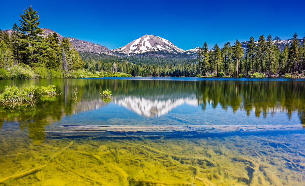
The southernmost national park in the Cascades, Lassen Volcanic National Park is a protected area that’s known for its steaming fumaroles, sprawling alpine meadows, and glistening high-elevation lakes.
Lassen Volcanic is centered around its namesake mountain, Lassen Peak, and it offers an incredible diversity of hiking opportunities for visitors to enjoy. Some of the many hiking trails in the park include the Bumpass Hell Trail, Kings Creek Fall Trail, Manzanita Lake Trail, Devastated Area Trail, and the Bathtub Lake Loop.

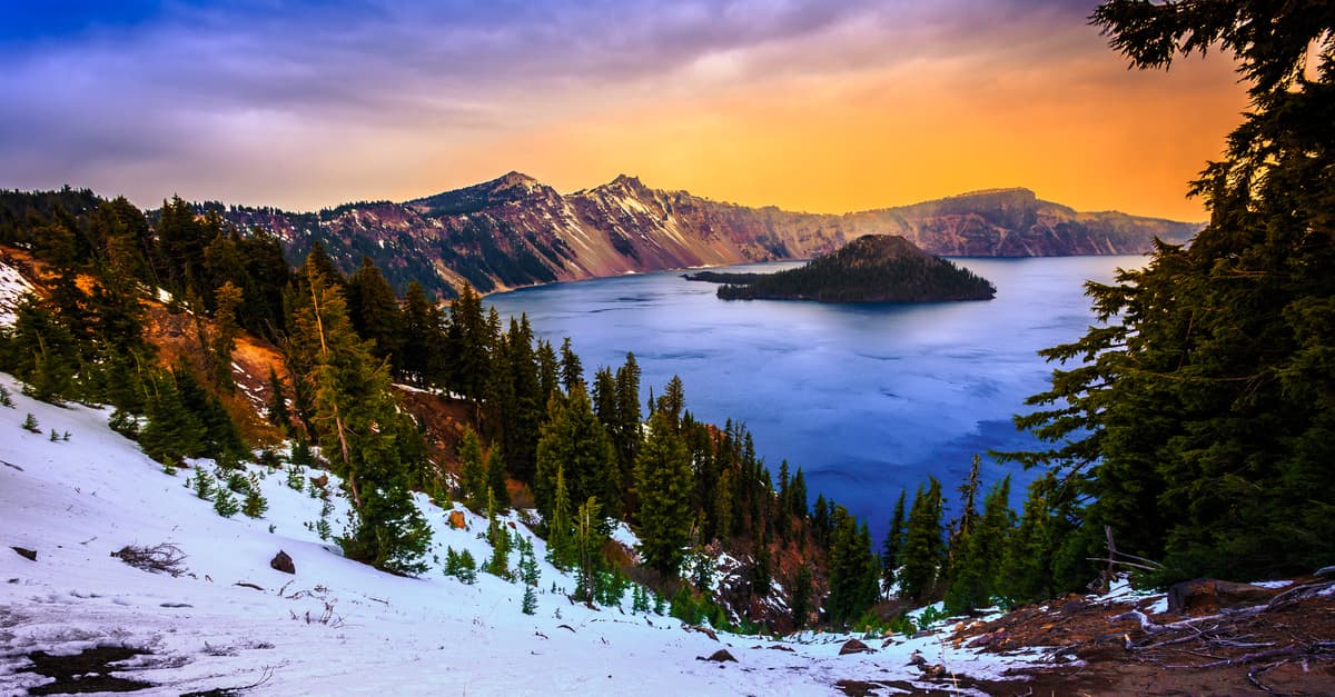
Crater Lake is Oregon’s only national park. The park’s signature lake is actually the result of a volcanic eruption that occurred around 7,700 years ago. Nowadays, Crater Lake is one of the National Park Service’s hidden gems as it boasts truly incredible scenery but only a fraction of the visitor numbers that we see at places like Yosemite and Yellowstone.
Although Crater Lake typically experiences lingering snow cover at relatively low elevations until early summer, there are plenty of great hikes to enjoy in the park when the snow finally melts. Some of the park’s best hikes include the Cleetwood Cove Trail, Pinnacles Trail, Garfield Peak Trail, Mount Scott Trail, and Discovery Point Trail.
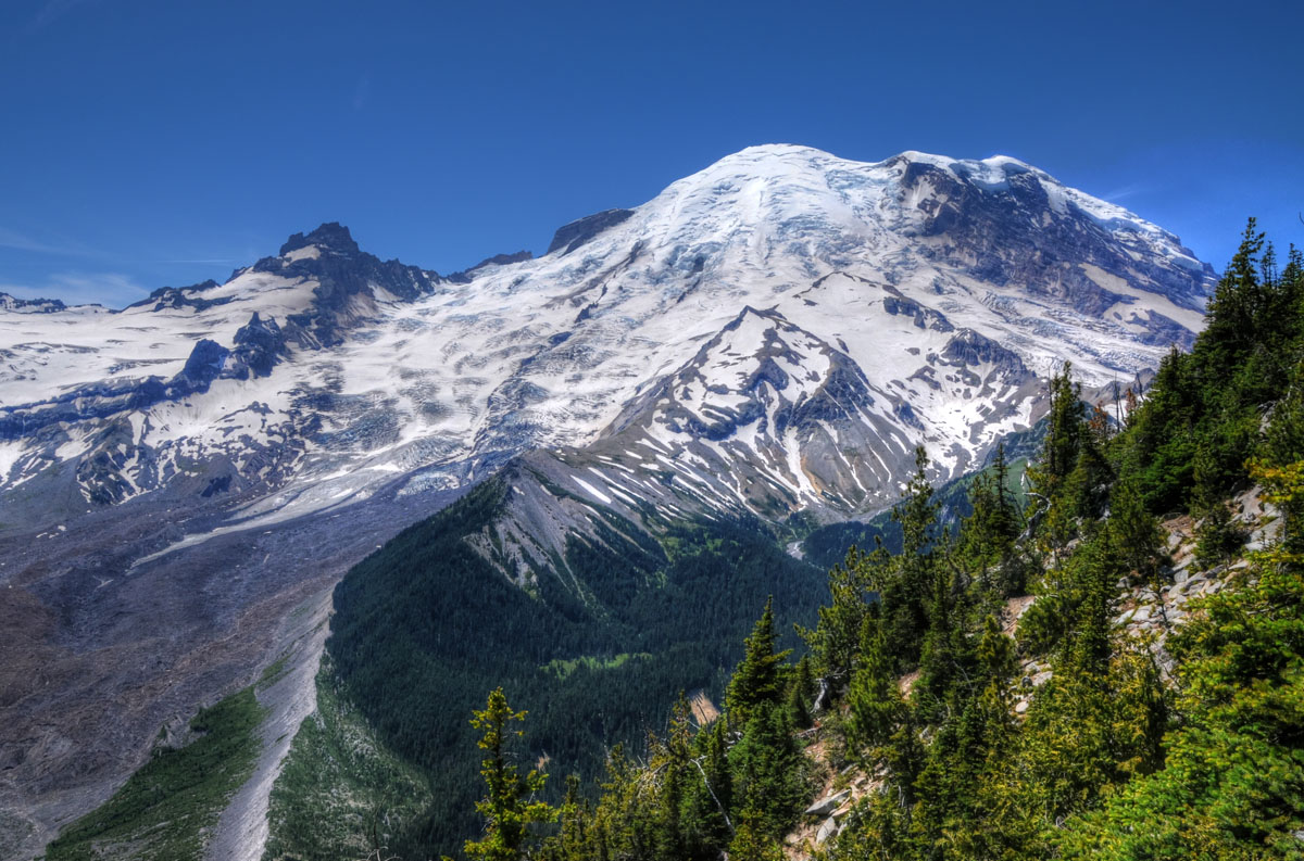
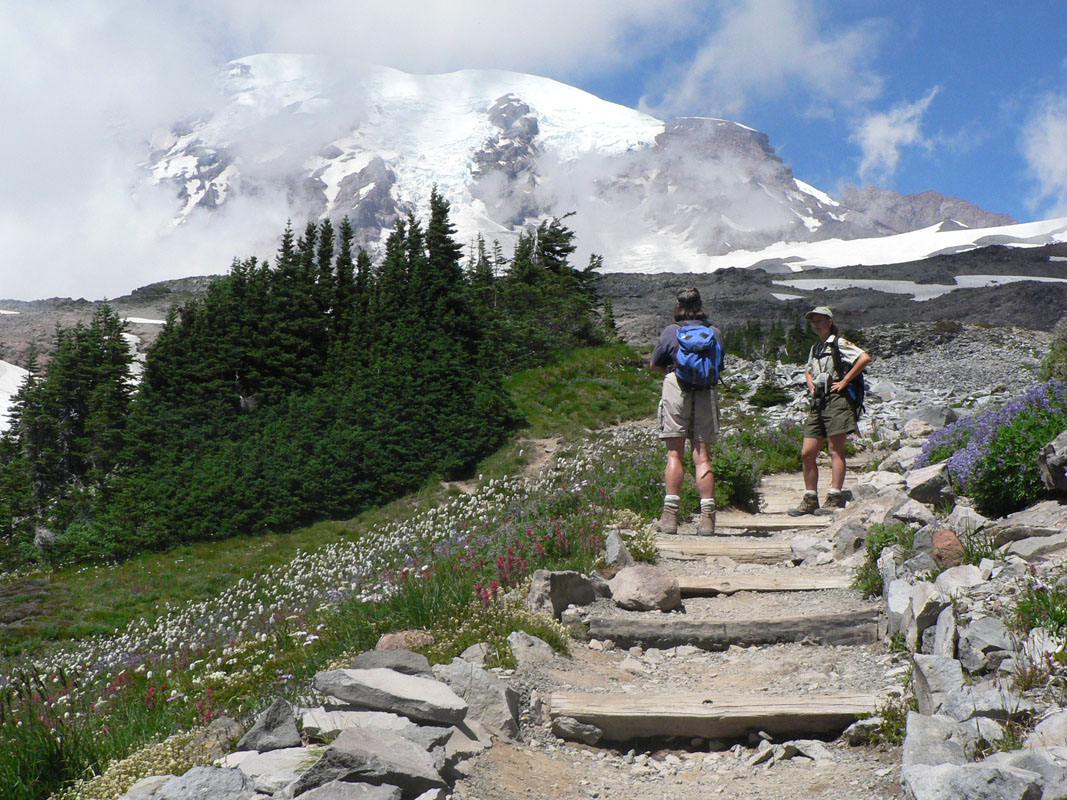
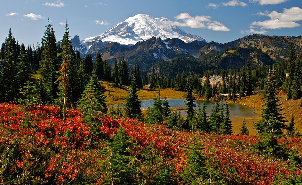
The highlight of Washington’s Mount Rainier National Park is unsurprisingly Mount Rainier itself. However, even if you aren’t feeling up for a mountaineering trip, there are plenty of great things to do in the national park.
Some of the many day hikes that you can enjoy in the park include the Rampart Ridge Trail, Twin Firs Loop Trail, Nisqually Vista Trail, Shadow Lakes Trail, Tolmie Peak Trail, and the Box Canyon Loop Trail.
Additionally, Mount Rainier is home to the famous Wonderland Trail, which is a 93 mi (150 km) long backcountry route that completely encircles Mount Rainier. This hike is one of the most popular in the park for experienced backpackers. Due to its popularity, you need to get a wilderness permit for this hike via a lottery system.
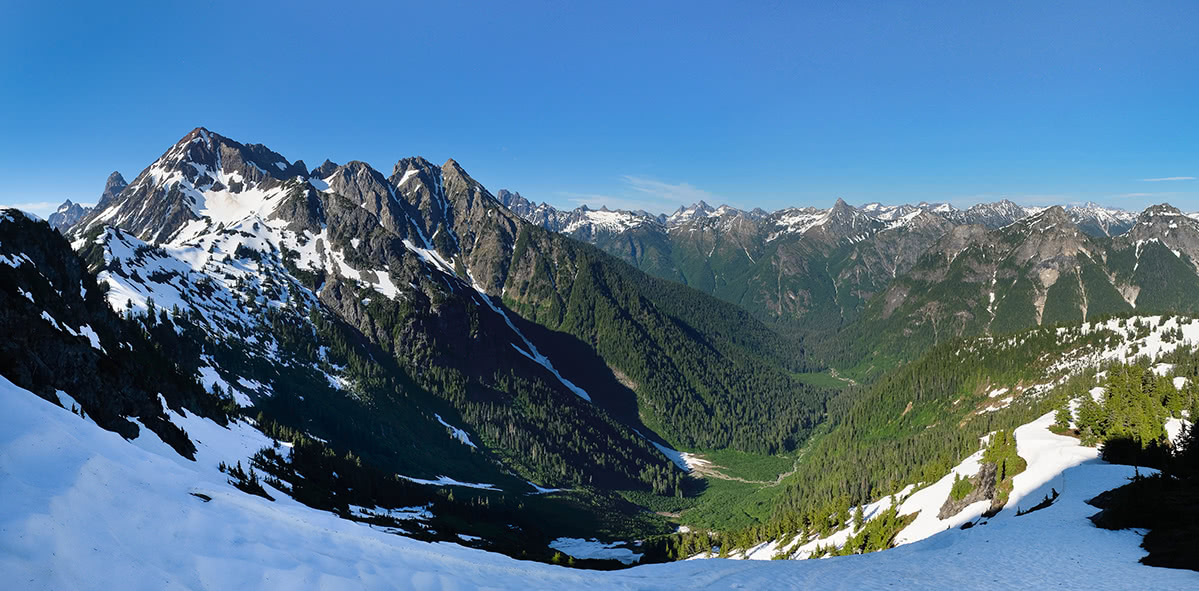
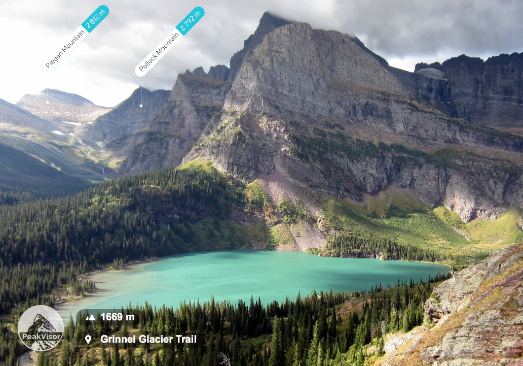
North Cascades National Park is one of the largest national parks in the contiguous United States, and it is one of the more remote parks in the Cascades. It is located in the northern part of Washington state near the international border with Canada and it is known for its dense concentration of highly glaciated peaks.
Nearly all of the national park is part of a designated wilderness, so it’s a fantastic destination for the hikers among us. Backcountry permits are required for overnight trips in the park and nearly 60 percent of the park’s backcountry campsites can be reserved in advance.
Whether you’re looking for a day hike or a backpacking trip, however, there are plenty of amazing hiking trails in North Cascades National Park for trekkers to enjoy. Some of the most popular hiking trails in the park include the Easy Pass Trail, Diablo Lake Trail, Thornton Lake Trail, and Sourdough Mountain Trail.

In addition to shorter day hiking and backpacking trails, there are a number of long-distance hiking trails that travel through the Cascades.
The most notable of these trails is easily the Pacific Crest Trail (PCT), which runs for 2,653 mi (4,270 km) from California’s border with Mexico to Washington’s border with Canada. In fact, the midpoint of the trail is located near Mount Lassen in northern California, which itself is situated close to the southern terminus of the Cascades and the northern terminus of the Sierra Nevada.
Although the PCT technically heads to the west of the main crest of the Cascades in northern California as it heads toward the Klamath Mountains, it rejoins the Cascades in Oregon. The trail then takes hikers along the crest of the range until they reach Canada. Along the way, it passes through most of the Cascades’ major national parks and forests and it gives you a chance to see some of the most stunning wilderness areas in the range.
While the PCT is the preeminent long-distance hike in the Cascades, there’s another long-distance trail called the Pacific Northwest Trail (PNT) that cuts across the northern part of the range.
The PNT travels for about 1,200 mi (1,900 km) from Montana’s Glacier National Park through the Idaho Panhandle to Washington’s Cape Alava. It travels through the Pasayten Wilderness and North Cascades National Park as it crosses the Cascades.
Keep in mind that the PNT is much less commonly traveled than the PCT, so it’s generally only recommended for very experienced hikers. The trail associations for both the PCT and the PNT offer a lot of information online about both hikes, so they’re great resources if you’re considering a thru-hike or section hike of either route.
The Cascades are one of the premier mountaineering destinations in the United States. Due to the range’s high concentration of glaciers and granite, it is a popular climbing area among mountaineers, particularly those looking to train for larger objectives in the Himalaya, Andes, and other major ranges around the world.
However, the Cascades are an incredible mountaineering location in their own right and much of the notable early mountaineering achievements in the US took place within the range. The gold standard for mountaineering guidebooks in the range is the three-part Cascade Alpine Guide: Climbing and High Routes, which was written by legendary climber Fred Beckey.
Although there are too many noteworthy peaks to mention here, in this section, we’ll briefly discuss some of the more popular mountains to climb in the Cascades for experienced mountaineers.
As the most prominent peak in the US and the highest peak in Washington state, Mount Rainier has long been a popular climbing objective. The mountain’s close proximity to Seattle and its relatively short approach from the trailhead also make it a frequent objective for climbers in the region.

That said, Mount Rainier isn’t an easy peak to summit. All of the routes to the summit require some level of technical climbing ability and they require that climbers traverse fairly large stretches of glaciated terrain.
The normal route to the summit is the Disappointment Cleaver Route, which typically includes an overnight stop at Camp Muir (10,188 ft/3,105 m). There are a number of other routes on the mountain, including the Liberty Ridge Route and the Emmons Glacier Route, though both are more challenging than the Disappointment Cleaver Route.
Regardless of what route you take, any climb of Mount Rainier should be taken seriously. People die and get injured on the mountain every year—including experienced mountaineers. If you are not an experienced mountaineer in your own right, it’s highly recommended that you hire one of the three guide services that are authorized to run trips on the mountain.
Even though it is substantially shorter than Mount Rainier, Mount Baker is a truly fantastic mountaineering objective, especially if you’re looking for a shorter climbing trip. The mountain is mostly located in the Mount Baker Wilderness of the Mt. Baker-Snoqualmie National Forest. It is a fan favorite because it offers options for both first-time climbers and experienced mountaineers.
The Coleman/Deming Route is considered the normal route on Mount Baker, though there are plenty of other options to the summit, including the routes up the North Ridge and the Easton Glacier. Most climbers complete their trip up the mountain in 2 to 3 days, but it’s possible to extend or shorten your trip to suit your skill and experience level.
Keep in mind that Mount Baker is a very popular area. While you don’t need to get a climbing permit for a private trip up the mountain, it’s highly recommended that you register with the forest rangers so they know what your plans are in the event of an emergency.

Also note that Mount Baker is heavily glaciated and that the mountain is known for getting quite a lot of snow and rain. Summer avalanches are also possible on the mountain, so anyone looking to climb Baker should, at a minimum, understand the basics of avalanche avoidance and rescue.
If you are not an experienced mountaineer, it’s highly recommended that you hire a guide service for your trip up Mount Baker. There are many outfitters that offer guided trips up the mountain, so it’s generally possible to find one that offers a trip to suit your interests and budget.
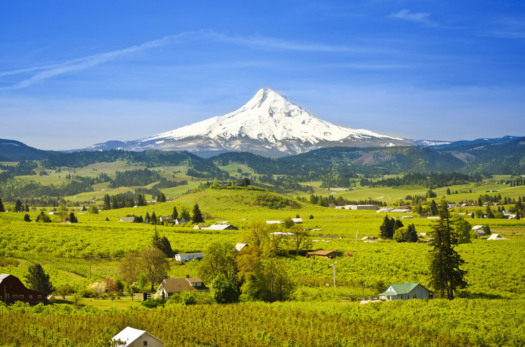
Mount Hood is the highest peak in Oregon and one of the most popular summits to climb in the state. There are a number of different routes that you can take to the summit, though the most popular routes aren’t overly difficult for experienced climbers.
The normal route on Mount Hood is the South Side Route, which has a maximum slope angle of around 35 degrees and is generally graded as a Class II climb. You must have a wilderness permit to climb the mountain from the south side during the spring, summer, and fall, so be sure to pick up your self-issued permit at the Wy'East Timberline Day Lodge before your climb.

Keep in mind that while Mount Hood’s southern route isn’t a particularly challenging climb from a technical perspective, the mountain is just as dangerous as any other peak in the Cascades. Anyone looking to climb the mountain on their own should have an ice axe and crampons as well as a climbing helmet to protect them from falling rocks.
If you are not an experienced mountaineer, consider hiring a guide for your trip up Mount Hood. There are many guide services in the region that offer both day trips on the mountain and multi-day introductory mountaineering courses so you can learn more about the techniques involved with climbing peaks like Mount Hood.
The Picket Range is one of the more remote and rugged areas of the North Cascades. This small subrange is only about 6 mi (9.7 km) long but it is situated in one of the wildest sections of North Cascades National Park.
The highest mountain in the Picket Range is Luna Peak (8,311 ft/2,533 m), though there are a number of other notable summits in the range such as Mount Fury, and Mount Terror.
Climbing adventures in the Picket Range are generally reserved only for very experienced climbers as trips into the region require extensive periods of backpacking, bushwacking, and technical climbing.
There are a number of different climbing routes in the range, some of which take you to individual peaks. Additionally, there are half a dozen different traverse routes that you can take to summit a handful of peaks in the range over the course of about a week.
Either way, mountaineering in the Picket Range is not for inexperienced climbers. The remoteness of the range and difficulty of most of the routes demand a high level of skill from all prospective mountaineers.

If you’re considering climbing in the range but don’t think you’re ready to do so on your own, consider contacting a guide service in the region to see if they can put together a trip that meets your needs.
The Cascades are home to some of the best ski resorts in the western United States. Here’s a look at some of the most popular ski areas in the range to help you plan your next winter trip to the Pacific Northwest.
Located on the crest of Stevens Pass in the Cascade Range in Washington, Stevens Pass Ski Resort is a downhill ski area that averages 460 inches (1,168 cm) of snowfall a year. It offers 1,125 acres (455 ha) of skiable terrain and more than 50 ski runs for winter recreation enthusiasts to enjoy.
Stevens Pass is located within two popular national forests, Mt. Baker-Snoqualmie and Wenatchee National Forest. It also offers a variety of lodging, restaurants, and shopping opportunities for visitors to check out when not out on the slopes.

The Mt. Hood Skibowl is an outdoor recreation area located on Mount Hood near Government Camp, Oregon. The Mt. Hood Skibowl gets approximately 300 inches (762 cm) of snow a year and offers 960 acres (388 ha) of skiable terrain.
At just over 1 hour away from the city by car, Mount Hood is the closest ski venue to Portland, making the area a popular getaway for locals. Although the Mt. Hood Skibowl is known for its ample winter recreation opportunities, the surrounding wilderness can be enjoyed by hikers, campers, and backpackers all year long.

The Timberline Lodge Ski Area is another one of Mount Hood’s popular ski resorts. In fact, the lodge is a national historic landmark and it is one of the few resorts in the US where the main skiing area is actually located at a lower elevation than the lodge itself.
Although it shares the mountain with a number of other ski areas, the Timberline Lodge area is located on the southern face of Mount Hood. It was one of the first ski areas in the state to have a rope tow. When the resort’s Magic Mile chairlift was built in the late 1930s, it was one of the longest such chairlifts in the world.
The Timberline Lodge Ski Area receives approximately 540 in (1,370 cm) of snow each year and it is the only outdoor ski area that provides year-round skiing opportunities. This makes it a popular destination in the summer months, especially for competitive snowsports athletes seeking out year-round training opportunities.

The Mount Bachelor Ski Resort (normally referred to just as ‘Mount Bachelor’) is a major ski area located just to the southwest of the city of Bend, Oregon. With over 4,300 acres (1,740 ha) of lift-accessible skiable terrain, Mount Bachelor is one of the largest ski areas in the entire US.
Weather permitting, Mount Bachelor is normally open from November through May. The resort has more than 100 trails for skiers and snowboarders to enjoy during the winter months. During the summer, Mount Bachelor also features a mountain bike park that’s open to the public.

One of the most popular ski areas in Washington state, Mount Baker is a true haven for snowsports enthusiasts in the winter months. In fact, the resort claims to have received the greatest ever recorded snowfall in a single season when it measured 1,140 in (2,896 cm) of snowfall during the winter of 1998–99.
Interestingly, the Mount Baker Ski Resort is actually located closer to the peak of Mount Shuksan than it is to the peak of Mount Baker. Nevertheless, it is well-known in the region for its plethora of challenging in-bounds pistes and for its great access to the region’s backcountry skiing opportunities.
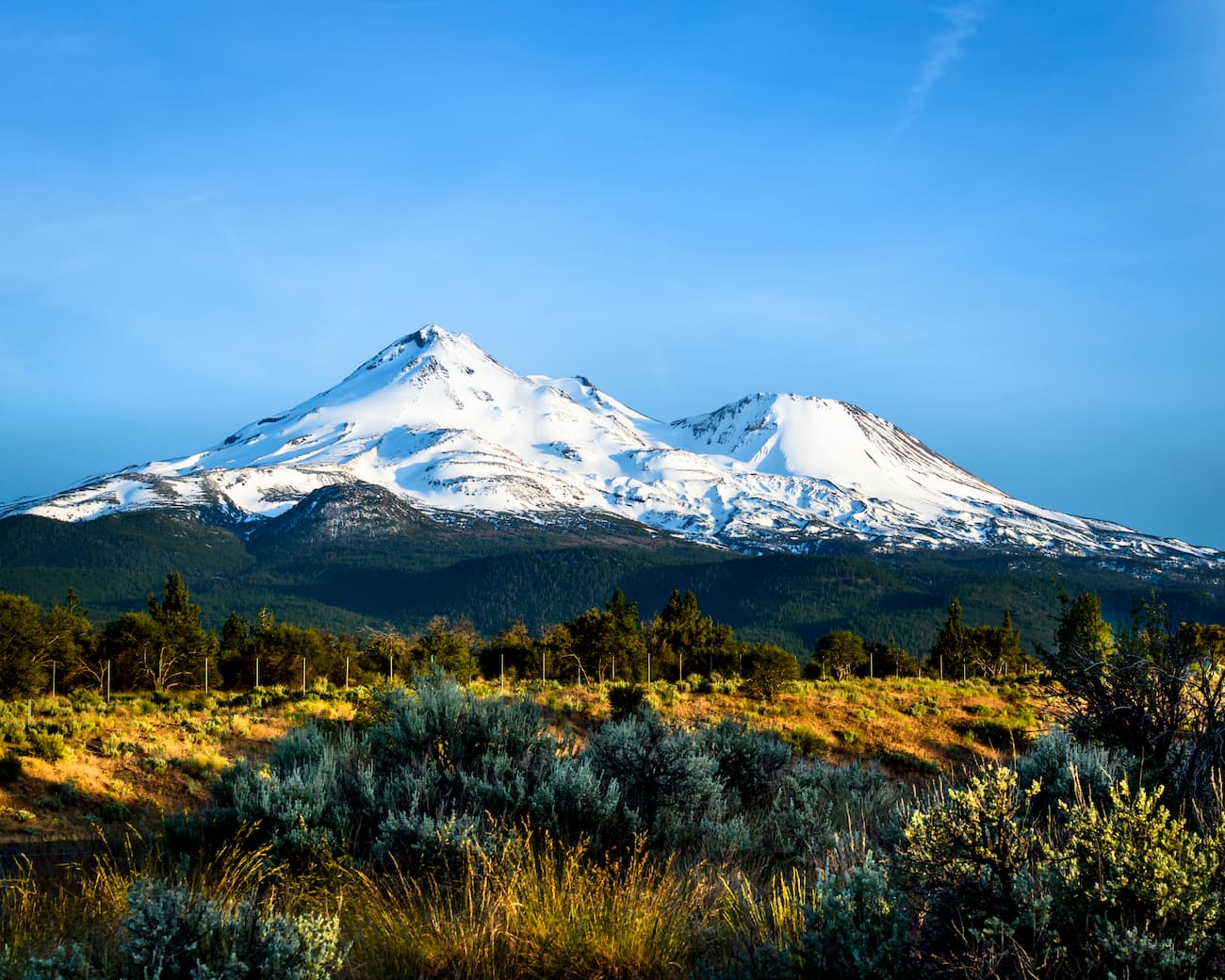
The aptly named Mount Shasta Ski Park is located near northern California’s Mount Shasta. It encompasses a number of smaller peaks to the south of the main mountain and it is easily accessible from Interstate 5 from the nearby city of Mount Shasta.
Although the resort isn’t as big as some of the other ski areas in the range, it has no shortage of great trails for snowsports enthusiasts to enjoy. There are more than 30 maintained trails on the mountain, many of which are rated for beginners and intermediate skiers, so it’s a nice option for people who are looking to improve their technique.

Despite the fact that it is one of the most rugged ranges in the United States, the Cascades are located within close proximity of a number of major cities. In fact, the range is situated within driving distance of some of the largest communities in the Pacific Northwest, so it’s one of the most accessible major mountain ranges on the continent.
Here’s a quick look at some of the biggest cities in the region to help you plan your next trip to the Cascade Range.
The city of Seattle is located just to the west of the northern part of the Cascades in the coastal part of Washington state. It is home to over 730,000 people in its urban core and more than 4 million people in its metro area, which makes it the largest city in the Pacific Northwest region.
Seattle is a bustling city that’s known for its coffee culture, annual festivals, museums, and performing arts scene. The city’s proximity to both the ocean and the mountains also makes it an incredible destination for anyone who loves outdoor adventure.
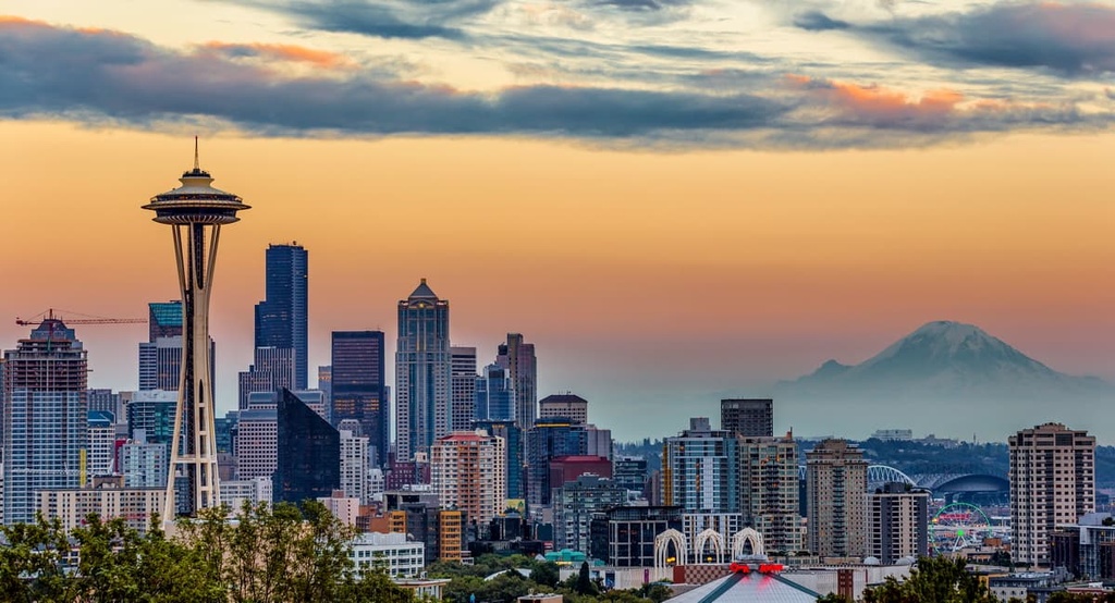
Of all the cities in the region, Seattle is one of the most easily accessible as it has excellent road, rail, ferry, and air links to the rest of the western US. The city’s international airport is also one of the largest in the region. You can also get around Seattle easily via light rail or bus, and you can get to some of the area’s most popular hiking destinations in just a short drive from the city center.
One of the more unique communities in the Cascades, Leavenworth is a town of around 2,000 people that’s located in the heart of the North Cascades to the east of Seattle. Interestingly, Leavenworth was modeled on a Bavarian village in Germany, so many of its buildings feature typical Bavarian-esque architecture.
The Bavarian theme of Leavenworth came about as a way to kick-start the tourism industry in what was formerly a logging town. This unique aspect of Leavenworth makes it a popular destination for both domestic and international tourists to this day.
Leavenworth is also a popular destination for climbers as the surrounding region features high-quality granite cliffs that feature some world-class climbing routes. The town is also situated within driving distance of many popular summits in the North Cascades.

You can get to Leavenworth easily by road from other major cities in the region. For example, Leavenworth is just 2 hours from Seattle-Tacoma Airport by car. Leavenworth is also located along an Amtrak line, so you can get to the town from either Seattle or Spokane by train.
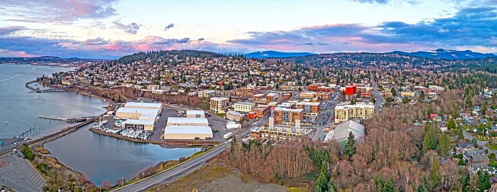
Bellingham is a city of around 92,000 people that’s located in northwestern Washington near the state’s international border with Canada. It is a very popular tourist destination thanks to its proximity to both the North Cascades and the San Juan Islands.
Among climbers, hikers, and skiers, Bellingham is a particularly popular destination as the city is located just a short drive from the Mount Baker Ski Area. Other great things to do in the city include checking out its many museums and craft breweries.
Thanks to its location along Interstate 5, Bellingham is easy to get to by road from either Seattle or Vancouver. You can also fly directly to Bellingham as the city is home to an international airport. Bellingham also has an Amtrak station, which provides train connections to Seattle and Vancouver. You can also take the Alaska Marine Highway ferries from Bellingham to Juneau, Ketchikan, and Haines in southeastern Alaska.
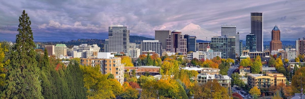
Portland is one of the most important cities in the Cascade region and the largest city in the state of Oregon. Not to be confused with Portland, Maine, the city of Portland in Oregon (which was actually named after its Maine counterpart) is a major metropolitan area that’s located near the confluence of the Columbia and Willamette rivers in the northwestern part of the state.
The city of Portland is home to around 650,000 people and it is known for its incredible visual and performing arts scene. Portland is also a sustainability-focused city and it is popular among foodies as it is home to countless craft breweries, independent restaurants, specialty coffee shops, and gourmet food trucks.
Additionally, Portland has one of the best city park systems in the US and it is located within driving distance of some of Oregon’s most popular peaks. The city is also easy to get to as it has good road, rail, and air connections to the rest of the US.
Located in the southwestern part of Oregon, Medford is a city of around 85,000 people that’s known for its proximity to the Cascades. Interestingly, like Portland, Medford was also named after a city on the East Coast, though in Medford’s case, it was named after Medford, Massachusetts.
Although it is located in the Rogue Valley between two major and very rainy mountain ranges (the Cascades to the west and the Siskiyou Mountains to the east), Medford is actually a relatively dry place as it lies in the rain shadow of the Siskiyou Mountains.
Medford isn’t as big of a metropolitan area as Portland, but its proximity to the mountains makes it a great place to stay for anyone looking to hike and climb in the southern Cascades. In fact, Medford is located just a few hours’ drive away from Mount Shasta in northern California.
You can get to Medford easily by car as the city is situated on Interstate 5. Additionally, Medford boasts one of the busiest airports in Oregon and it has air service to most of the major cities in the western US.

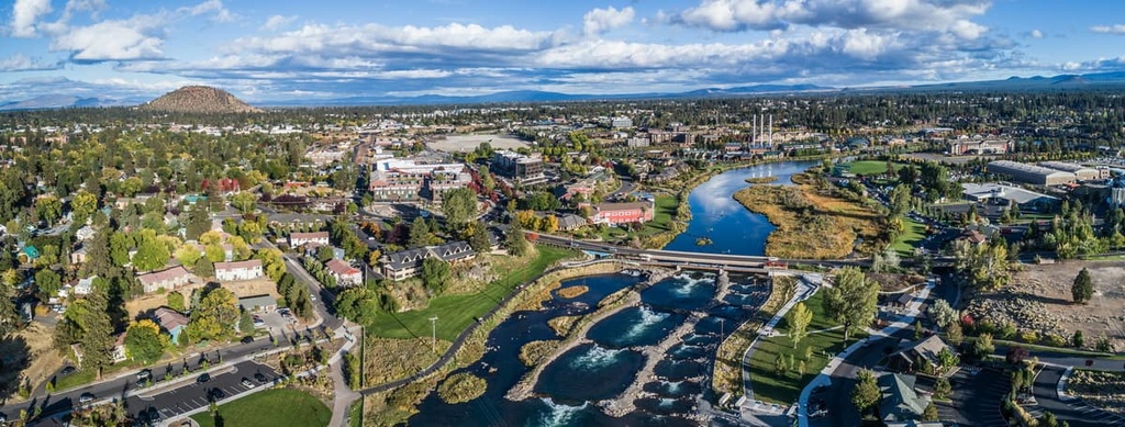
Bend is a city located in Deschutes County near the geographic center of the state of Oregon. The city is situated along the eastern slopes of the Cascades on the banks of the Deschutes River and it is home to around 100,000 people.
Of all of Oregon’s cities, Bend is perhaps the most popular among hikers and climbers due to its proximity to the Three Sisters as well as the city’s plethora of parks and climbing gyms. Bend is also home to dozens of craft breweries and it has a great assortment of restaurants for visitors to check out.
Bend is a bit trickier to get to than some of the other major cities in the Cascades region because it is located to the east of the range. That said, Bend is located just a 3-hour drive away from both Portland and Medford. You can also get to Bend by bus or train, and the city has a regional airport that offers flights to major destinations across the western part of the country.
Often considered to be the cultural capital of the southern Cascades, the city of Redding is a community of around 95,000 people that’s located along the Sacramento River, just a short distance to the west of Lassen Peak.
Redding became a boomtown during the California Gold Rush, though it managed to survive long past the initial rush by building up a copper and iron mining industry. Even as the mining industry waned, Redding continued to grow as a result of its burgeoning timber and tourism industries.
Nowadays, tourism remains a major part of the city’s economy as Redding is home to many museums and it is a gateway to California’s Cascades. You can get to Redding by road (it’s just 3.5 hours from San Francisco) and rail, so it’s a great place to start any trip to the Lassen Peak region.

Situated in the far northern part of California, Yreka is a community of around 8,000 people that also happens to be one of the most popular tourist destinations in the region.
Yreka is located along the northern slopes of Mount Shasta, so it’s a popular starting point for climbers looking to summit one of the Cascades’ major stratovolcanoes. The rivers around the town also offer excellent trout fishing opportunities and there is great backpacking to be had in the nearby Trinity Alps.
Due to its relatively small size, Yreka doesn’t have any commercial passenger train or air connections. However, you can get to Yreka easily by car as the town is located along Interstate 5 and California State Route 3.

Explore Cascade Range with the PeakVisor 3D Map and identify its summits.


14er
ultra
glacier
volcano
cascade-range-9000ers
washington-bulger
smoots-100
chemeketan-18-nw
mountaineers-6-peak-pin
mountaineers-5-peak-pin
cascade-volcanoes-pin
mazamas-16-nw-award
fred-beckey-great-peaks
washington-ultras
14er
ultra
glacier
volcano
cascade-range-9000ers
california-13ers
porcella-burns
western-state-climbers
western-state-climbers-star
chemeketan-18-nw
cascade-volcanoes-pin
mazamas-16-nw-award
fred-beckey-great-peaks
california-ultras
14er
ultra
glacier
volcano
cascade-range-9000ers
washington-bulger
smoots-100
chemeketan-18-nw
mountaineers-6-peak-pin
mountaineers-5-peak-pin
cascade-volcanoes-pin
mazamas-16-nw-award
fred-beckey-great-peaks
washington-ultras
14er
ultra
glacier
volcano
cascade-range-9000ers
california-13ers
porcella-burns
western-state-climbers
western-state-climbers-star
chemeketan-18-nw
cascade-volcanoes-pin
mazamas-16-nw-award
fred-beckey-great-peaks
california-ultras
ultra
glacier
volcano
cascade-range-9000ers
washington-bulger
smoots-100
chemeketan-18-nw
mountaineers-6-peak-pin
mountaineers-5-peak-pin
mountaineers-bakers-dozen
cascade-volcanoes-pin
mazamas-16-nw-award
washington-ultras
ultra
glacier
volcano
cascade-range-9000ers
washington-bulger
washington-fire-lookouts
smoots-100
chemeketan-18-nw
mountaineers-6-peak-pin
mountaineers-5-peak-pin
cascade-volcanoes-pin
mazamas-guardian-award
mazamas-16-nw-award
washington-ultras
ultra
glacier
volcano
oregon-9000ers
cascade-range-9000ers
chemeketan-18-nw
cascade-volcanoes-pin
mazamas-guardian-award
mazamas-cascades-award
mazamas-16-nw-award
fred-beckey-great-peaks
oregon-ultras
ultra
glacier
volcano
cascade-range-9000ers
washington-bulger
smoots-100
chemeketan-18-nw
mountaineers-6-peak-pin
mountaineers-5-peak-pin
cascade-volcanoes-pin
mazamas-16-nw-award
washington-ultras
ultra
glacier
volcano
oregon-9000ers
cascade-range-9000ers
chemeketan-18-nw
cascade-volcanoes-pin
mazamas-cascades-award
mazamas-16-nw-award
oregon-ultras
ultra
glacier
volcano
oregon-9000ers
cascade-range-9000ers
western-state-climbers
western-state-climbers-star
chemeketan-18-nw
cascade-volcanoes-pin
mazamas-cascades-award
mazamas-16-nw-award
oregon-ultras
ultra
mid-state-milers
cascade-range-9000ers
washington-bulger
smoots-100
chemeketan-18-nw
mountaineers-cascade-classic
mazamas-16-nw-award
washington-ultras

