
Scan the QR code and open PeakVisor on your phone
Mount Saint Helens National Volcanic Monument has 34 named peaks. The highest is Lawetlat'la at 2,549 m. Other notable peaks include Dogs Head (historical), Dogs Head Peak and Lava Dome.
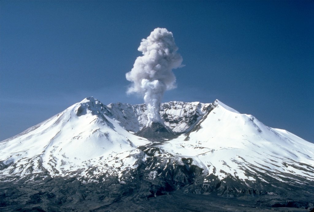
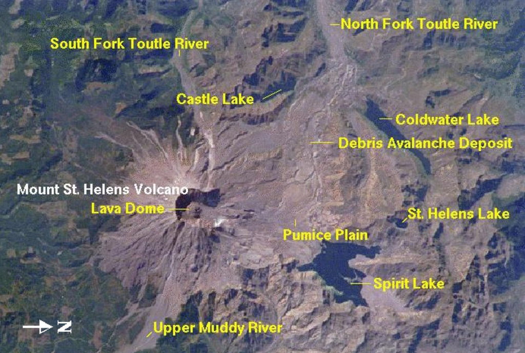
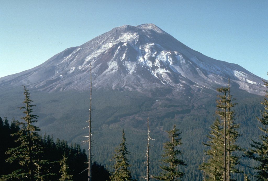
At 8:32 a.m. on May 18, 1980, Washington State’s fifth highest peak, Mount Saint Helens erupted, forcing super-heated ash and tephra 80,000 feet into the atmosphere and deposited ash in 11 surrounding states. The north face of this once 9,677-foot volcano was reduced to a horseshoe-shaped crater, its highest point reaching 8,365 feet.
The most significant eruption to occur in the contiguous United States, the eruption resulted in a series of large volcanic mudslides that stretched for nearly 50 miles. Sadly, 57 people were killed as a result of the eruption and hundreds of square miles were reduced to volcanic wasteland.
Just two years later, in August of 1982, 110,000 acres were set aside for research, recreation, and education. Though the preservation of the site was intended to allow for the eruption to be scientifically studied, today, the Mount St. Helens National Volcanic Monument is visited by over 500,000 people who are interested in learning about and exploring one of the country’s most notorious volcanic eruptions.
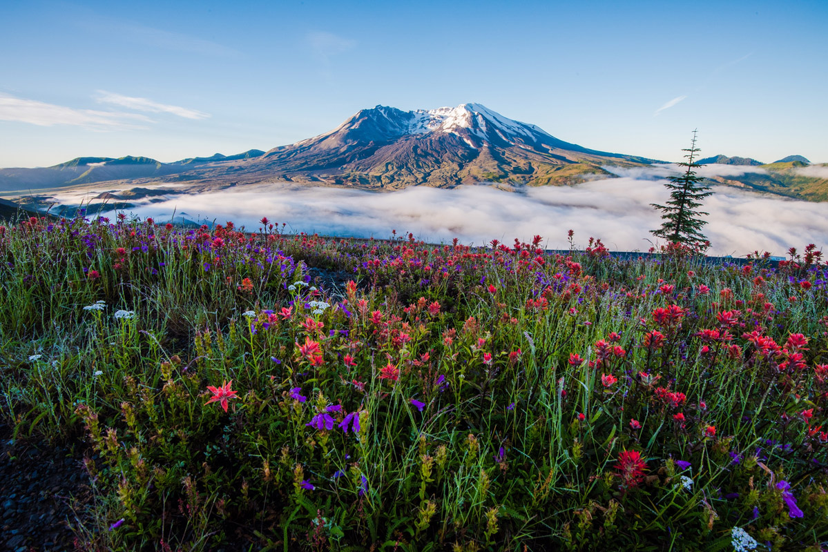
Mount Saint Helens is located in the Cascade Range and is part of the Cascade Volcanic Arc, a portion of the Pacific Ring of Fire that contains over 160 active volcanoes. Though the National Monument is best-known for its namesake summit, there are a variety of recreational opportunities in the park. There are 25 named mountains in the Mount Saint Helens National Volcanic Monument including Dogs Head, a tall rocky pinnacle that is a popular waypoint for pre-eruption climbers, Mount Whittier, which took the brunt of the 1980 eruption, and Goat Mountain, which offers striking views of the volcano’s crater and blast area.
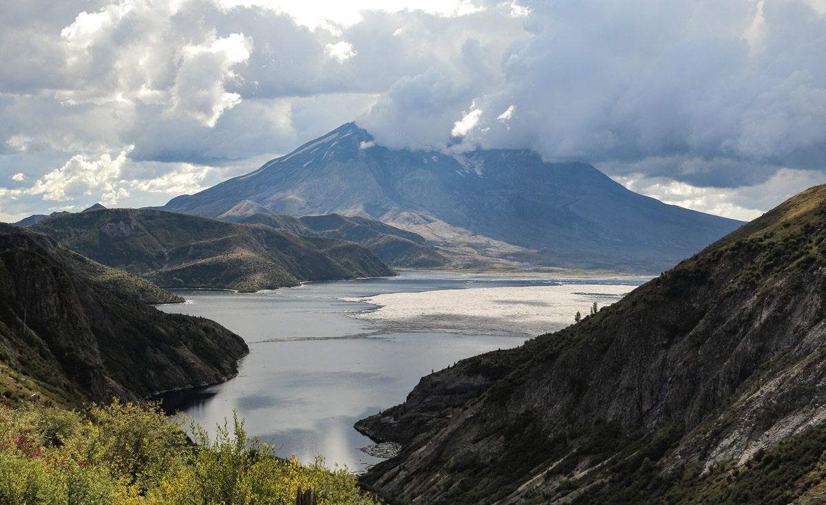
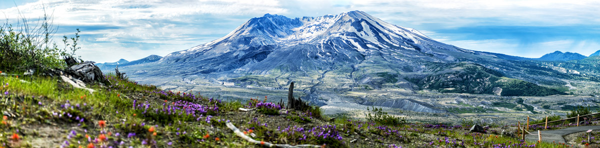
The Mount St. Helens National Monument is a truly unique and special acknowledgment of natural recovery and the undeniable power of Mother Nature. Arguably the most popular (and best) way to experience the mountain is to spend time driving along Highway 504 and stopping at local trails and viewpoints to appreciate the blast zone. Highway 504 was once the main route to Spirit Lake, a popular summer destination for hikers, campers, and beachcombers. Today, it’s buried beneath the blast, replaced by the Spirit Lake Memorial Highway.
The Johnston Ridge Observatory sits at the end of route 504, just four miles from Mount Saint Helens. The observatory emphasizes the incredible geologic history of the volcano, offers eyewitness accounts of the explosion, and offers ranger-led programs every hour. In fact, interpretive displays portray the exact sequence of events that transformed the landscape forever. The observatory sits near the site of volcanologist David A. Johnston’s camp on the morning of the major eruption. Johnston was the first to report the eruption and was a principal scientist on the USGS monitoring team.

A half-mile trail, aptly named the Eruption Trail, leads to views of the lava dome, blast zone, and crater. Another popular trail, Harry's Ridge Trail, also departs from the Johnston Ridge Observatory. This 8-mile trail offers sweeping views of Spirit Lake, Coldwater Peak, Mount Adams, the pumice plains, and, of course, the blast damage of the beloved Mount Saint Helens. This trail is particularly popular in the Spring when wildflowers blanket the landscape.
At 13,042 long, Ape Cave is the longest continuous lava tube in the continental United States and the third longest lava tube in North America. Ape Cave not only offers stunning views of Mount Saint Helens lahar region, it’s an unusual and remarkable anomaly in the region. The cave formed about 2,000 years ago when lava poured down the southern flank of Mount St. Helens. This formation is particularly unusual in this region, as this type of volcano usually erupts lava that is much thicker.
Popular trails include the Cave Trail No. 239, which runs along the interior of the cave and the lower Ape Cave is just .75 miles long and can be hiked in an hour. This trail is most famous for a block of cooled lava known as ‘Meatball.’
The Lava Canyon trail sits on the southeast edge of the national monument and highlights the incredibly geologic history of the region. A dramatic waterfall now defines Lava Canyon, as a result of the mountain’s violent, volcanic mudslide. From the parking area, visitors can take a quick trip along a paved path to an observation point overlooking the surrounding landscape. Or, for a longer adventure, hikers can opt to travel further into the canyon, periodically skirting high cliffs and dizzying suspension bridges.
The Loowit Trail is designed with long distance hikers in mind. The 30-mile trail, which circumnavigates Mount Saint Helens, crosses directly through blast zones, mountain gullies, and highlights the stark contrasts of this unpredictable landscape. Loowit is not for the faint of heart – each year hikers are forced to turn around as a result of erratic weather and impassable gullies. It’s important that hikers are well-prepared and savvy in route-finding before attempting this trek.
The view of Mount Saint Helens and Spirit Lake as seen from the Norway Pass Trail.
Eco Park Resort is the closest accommodation to Mount Saint Helens (unless you’re camping on or around the mountain. Eco Park offers a variety of lodging options including cabins, RV sites, yurts, and tent sites. The accommodations are rustic but contain a handful of modern amenities. Most importantly, the resort is just 30 minutes away from the most popular and scenic hiking trails in the region and is the perfect place to catch up on some rest in between trips to Mount Saint Helens.
Silver Lake Resort offers various accommodations including a lakeside motel, RV and tent sites, and cabins. Every room in the waterfront hotel offers stunning views overlooking the lake, and if you’re lucky enough to score a lower level unit, you can even fish from your balcony. Boating, fishing, and swimming are popular at Silver Lake, and Mount St. Helens is just an hour away.
Castle Rock isn’t what you’d consider to be a large town, but it’s the best basecamp for exploring Mount St. Helens. Castle Rock is connected to two of the most popular Mount Saint Helens attractions – the Spirit Lake Memorial Highway and the Mount St. Helens National Monument Visitor Center. Downtown Castle Rock also offers a variety of accommodations, shops, restaurants, and antique stores.


glacier
volcano
washington-bulger
smoots-100
chemeketan-18-nw
mountaineers-6-peak-pin
cascade-volcanoes-pin
mazamas-guardian-award
mazamas-16-nw-award
fred-beckey-great-peaks
glacier
volcano
washington-bulger
smoots-100
chemeketan-18-nw
mountaineers-6-peak-pin
cascade-volcanoes-pin
mazamas-guardian-award
mazamas-16-nw-award
fred-beckey-great-peaks
The highest peak in Mount Saint Helens National Volcanic Monument is Lawetlat'la, at 2,549 m.
Notable peaks in Mount Saint Helens National Volcanic Monument include Lawetlat'la, Dogs Head (historical), Dogs Head Peak, Lava Dome and Crescent Ridge.


