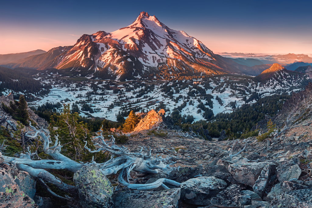
Mount Jefferson is a stratovolcano in the Cascade Volcanic Arc, part of the Cascade Range in the U.S. state of Oregon. The second highest mountain in Oregon, it is situated within Linn County, Jefferson County, and Marion County and forms part of the Mount Jefferson Wilderness. Due to the ruggedness of its surroundings, the mountain is one of the hardest volcanoes to reach in the Cascades. It is also a popular tourist destination despite its remoteness, with recreational activities including hiking, backpacking, mountaineering, and photography. Vegetation at Mount Jefferson is dominated by Douglas fir, silver fir, mountain hemlock, ponderosa pine, lodgepole pine, and several cedar species. Carnivores, insectivores, bats, rodents, deer, birds, and various other species inhabit the area.
Also known as Seekseekqua by Native American populations, the volcano was named after United States President Thomas Jefferson, and was first ascended by E. C. Cross and R. L. Farmer in 1888. It sits atop an area of crustal melting, and was produced by the subduction of the oceanic Juan de Fuca tectonic plate under the continental North American tectonic plate, forming about 730,000 years ago. Consisting of basaltic andesite, andesite, and dacite, the mountain has been extensively altered by glacial erosion. The surrounding area contains a number of other volcanic features like cinder cones, shield volcanoes, and tuyas (flat-topped, steep-sided volcanoes formed when lava erupts through a thick glacier or ice sheet). It is considered a low threat by the United States Geological Survey. Despite the low chance of future eruptions, many scientists still consider mudflows a major threat at Mount Jefferson.
By elevation Mount Jefferson is
# 39 out of 4345 in the Cascade Range # 1 out of 315 in Willamette National Forest # 3 out of 4749 in Oregon # 1 out of 104 in Jefferson County # 1 out of 160 in Linn County # 1 out of 33 in Mount Jefferson Wilderness # 1 out of 48 in Warm Springs Indian Reservation
By prominence Mount Jefferson is
# 8 out of 4345 in the Cascade Range # 1 out of 315 in Willamette National Forest # 78 out of 91437 in USA # 3 out of 4749 in Oregon # 1 out of 104 in Jefferson County # 1 out of 160 in Linn County # 1 out of 33 in Mount Jefferson Wilderness # 1 out of 48 in Warm Springs Indian Reservation
We use GPS information embedded into the photo when it is available.
3D mountains overlay
Adjust mountain panorama to perfectly match your photos because recorded by camera photo position might be imprecise.
Move tool
Rotate tool
Zoom
More customization
Choose which peak labels should make into the final photo and what photo title should be.
Next
Photo Location
Satellitte
Flat map
Relief map
Latitude
Longitude
Altitude
OR
Latitude
°'''
Longitude
°'''
Apply
Register Peak
Peak Name
Latitude
Longitude
Altitude
Register
Teleport
PeakVisor
This 3D model of Sagarmatha National Park in Nepal was made using the PeakVisor app topographic data. The mobile app features higher precision models worldwide, more topographic details, and works offline. Download PeakVisor maps today.
Download OBJ model
PeakVisor
The download should start shortly. If you find it useful please consider supporting the PeakVisor app.
PeakVisor for iOS and Android
Be a superhero of outdoor navigation with state-of-the-art 3D maps and mountain identification in the palm of your hand!


.jpg)
.jpg)


