
Scan the QR code and open PeakVisor on your phone
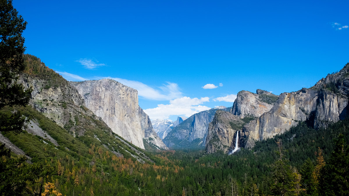
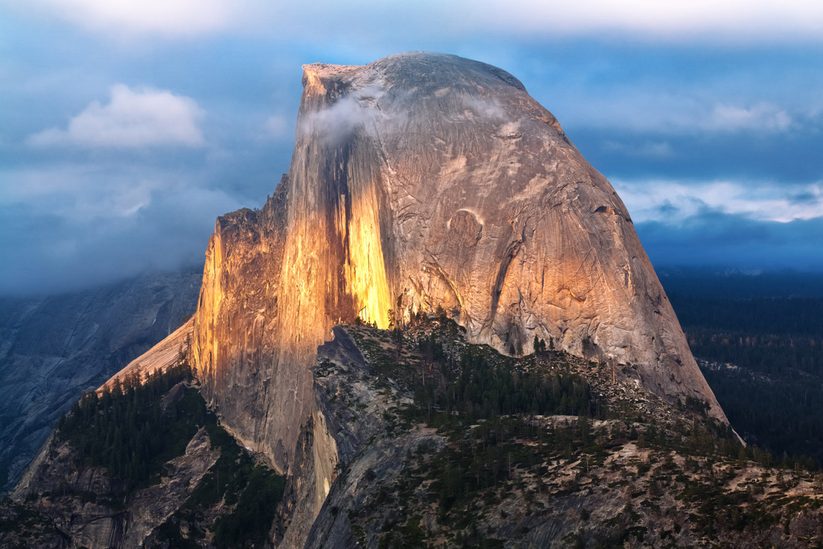
Spanning 748,436 acres (3,029 sq. km) in California’s Central Sierra Nevada, Yosemite National Park is one of the most famous and visited national parks in the United States. The park is particularly renowned for its superb rock climbing and notable formations like El Capitan (7,779 ft / 2,371 m) and Half Dome (8,839 ft / 2,694 m), some of the tallest rock faces in the contiguous U.S. Yosemite Valley is considered the birthplace of American rock climbing and today remains a mecca for the sport. There are 228 named summits in Yosemite National Park and three over 13,000 feet (3,962 m). Mount Lyell (13,100 ft/3,993 m) is the highest. Mount Conness (12,556 ft / 3,827 m) is the most prominent, with 2,625 feet (800 m) of autonomous height.
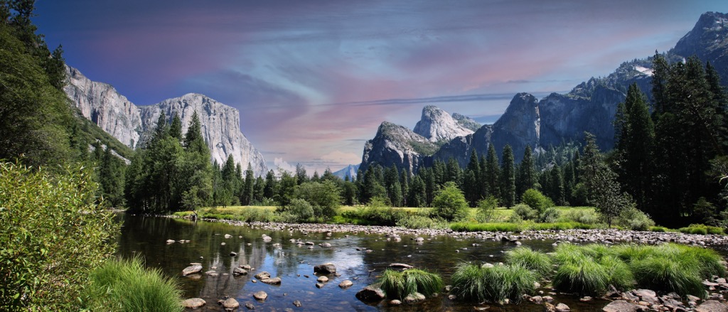
Yosemite National Park is one of the largest national parks in the United States. Nestled in the Central Sierra Nevada, Yosemite is adjacent to three wilderness areas: the Ansel Adams Wilderness to the southeast, Hoover Wilderness to the northeast, and Emigrant Wilderness to the north. However, the Yosemite Valley, around which many of the most famous granite formations rise—represents only 1% of the park’s total land area.

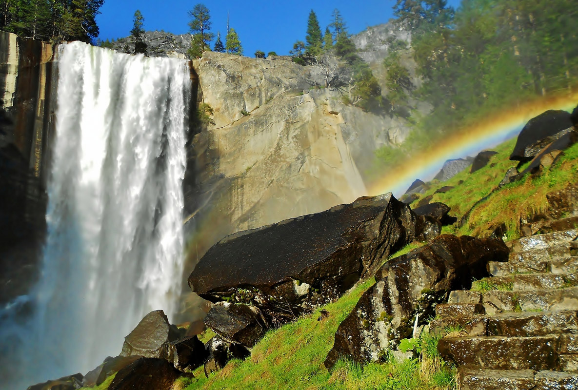
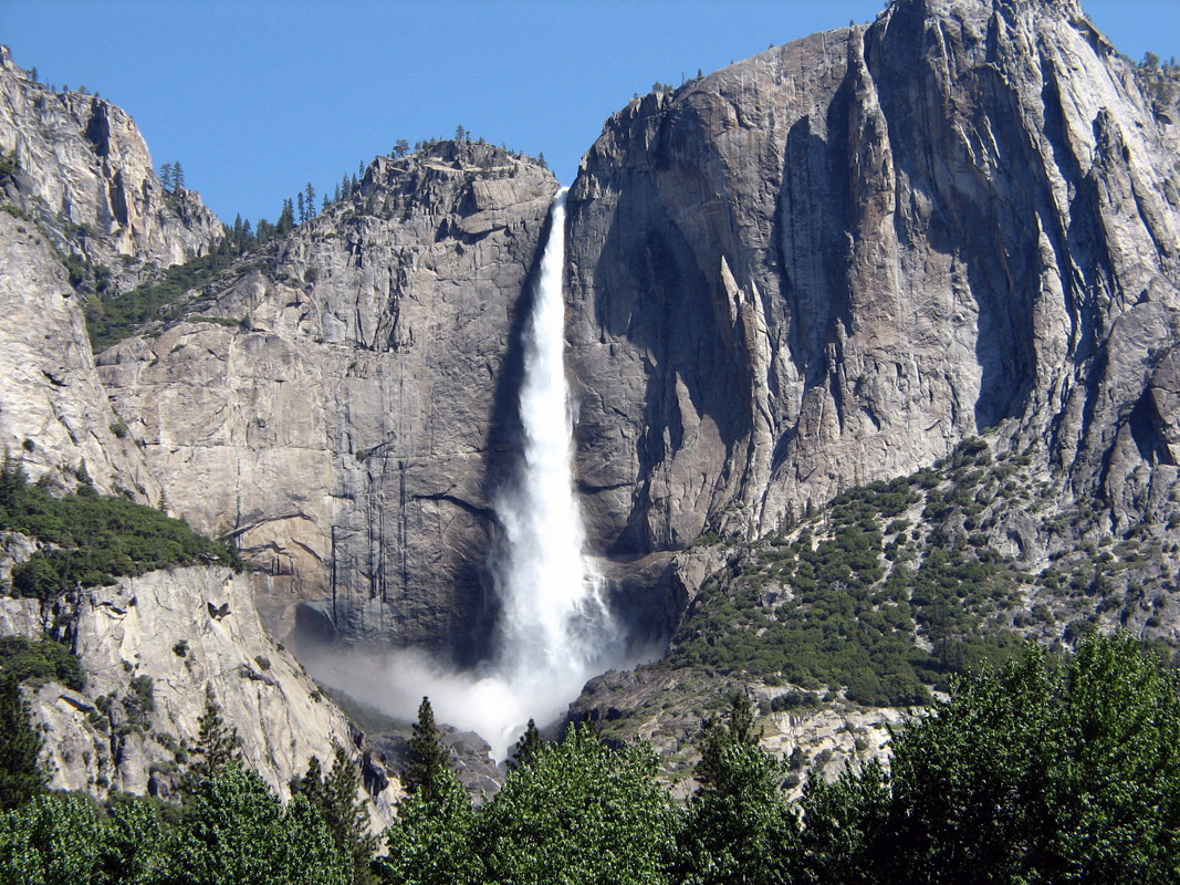
In addition to the world-famous granite, the 748,436-acre (3,029 sq. km) park is home to thousands of lakes and ponds and 1,600 miles (2,600 km) of rivers and streams. The Yosemite Valley is bisected by the Merced River, the most famous river in the park, along with the Tuolumne (both federally designated as “Wild and Scenic” rivers). The park features many waterfalls, including Bridalveil Falls, Yosemite Falls, and Vernal Falls.

Other park features include the meadows of Tuolumne and Dana, the Clark Range, the Cathedral Range, and the Kuna Crest. The through-hiking Sierra Crest and the Pacific Crest Trails also track through Yosemite National Park. The park’s largest glacier, the Lyell Glacier, is one of the last remaining in the Sierra Nevada. Although still called a glacier by observers, the ice has retreated so much that it has lost movement, and is now considered a remnant glacier or snowfield.

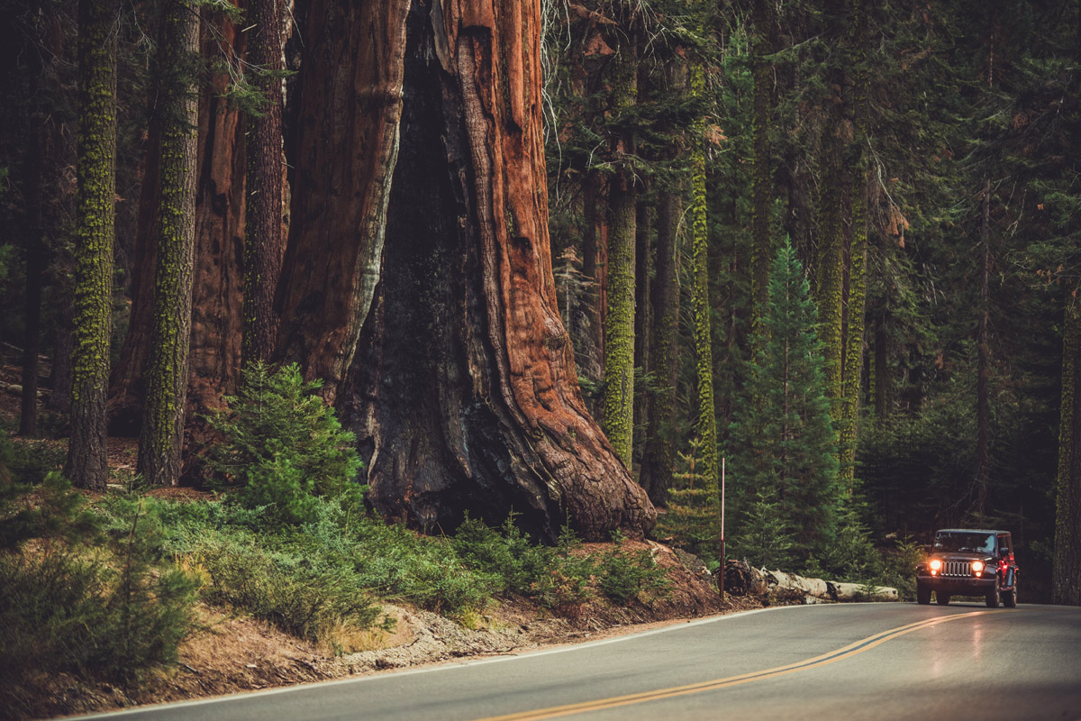
The park is also famous for several groves of giant sequoia trees, some of the world's largest, tallest, and oldest trees. These include the Mariposa Grove, Tuolumne Grove, and Merced Grove.
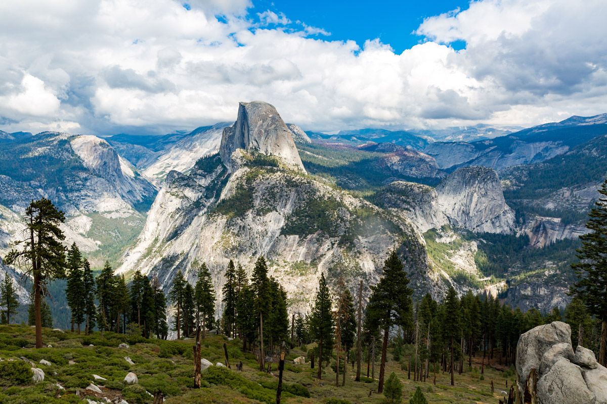
Yosemite National Park is best known for the spectacular granite cliffs soaring high above Yosemite Valley, particularly Half Dome (8,839 ft / 2,694 m), El Capitan (7,779 ft / 2,371 m), and Mount Watkins (8,497 ft / 2,590 m). Cathedral Peak (10,869 ft / 3,313 m) and Sentinel Dome (8,127 ft / 2,447 m) are two more of the most famous granite formations in the park.
More than 90% of the park’s landscape comprises Cretaceous granite formed between 105 and 85 million years ago. Yosemite’s granite monoliths contain various minerals, including quartz, plagioclase, hornblende, potassium feldspar, and biotite.

All the granites in Yosemite are part of the Sierra Nevada Batholith, a large amalgamation of plutonic rock—bodies of molten rock material (magma) that froze deep inside the Earth instead of erupting and forming traditional volcanic rock. The Batholith formed after the Pacific Plate began to subduct beneath the North American Plate around 220 million years ago. The resulting granites were ultimately exposed to the surface by gradual erosion of the overlying rocks over tens of millions of years.
Glaciers carved out the resulting granite formations during the Ice Age. These massive bodies of ice sculpted Yosemite Valley and Lyell Canyon, carving out the characteristic “U” shape and the sheer faces on all sides. Ancient glaciers also formed many of the park's most famous lakes, including Mirror Lake and Tenaya Lake.

The oldest rocks in Yosemite National Park, however, are metamorphic. The park has two major metamorphic rock bands, both angling northwest. These are the remains of ancient sedimentary rocks, such as limestone and sandstone, deposited around 400–500 million years ago. There are also volcanic (igneous) rocks in the park, in sites like Little Devils Postpile near Tuolumne Meadows. These igneous rocks include basalt, andesite, and dacite.
Yosemite’s diverse ecosystems support a vast array of flora and fauna. The park boasts over 1,500 plant species, including sequoias, ponderosa and Jeffrey pines, and incense cedars. There are also diverse meadows of wildflowers, such as lupines, paintbrushes, and shooting stars, blanketing the valley and high country in spring and early summer. Yosemite’s Mariposa Grove, home to some of Earth's oldest and largest trees—giant sequoias—is a must-visit, particularly for the world-famous Grizzly Giant and California Tunnel Tree.

Wildlife enthusiasts can find an equally diverse range of fauna. Mule deer, black bears, bobcats, coyotes, marmots, and bighorn sheep are among the most common species on the ground. There are also numerous species of amphibians and reptiles, notably the Pacific treefrog, which is even found living in the cracks in the wall thousands of feet up on formations like El Capitan. In the skies, birdwatchers can appreciate bald eagles, peregrine falcons, Clark’s nutcrackers, and bright azure Steller's jays. The latter is among Yosemite’s most common (and striking) birds.
Yosemite National Park was designated as a UNESCO World Heritage Site in 1984 due to its abundance of granite cliffs, rivers, giant sequoias, and waterfalls. However, the history of the Yosemite area far predates the national park. Evidence suggests that humans have inhabited Yosemite Valley for at least 3,000 years.
However, after the California Gold Rush of the 1850s and the arrival of many white settlers, the region around Yosemite Valley began to change dramatically as these prospectors competed with the first people over resources and land. In the early 1840s, the Mariposa Wars began in an attempt to suppress resistance from these native people as the United States Army’s Mariposa Battalion charged into Yosemite Valley in pursuit of Ahwahneechee Chief Tenaya and his 200 men.
The Mariposa Battalion eventually captured and killed most of the Ahwahneechee while the survivors were taken as captives and joined the Mono Paiute people. After these wars, a few native peoples continued to live in the Yosemite region, some of whom started working in the growing tourism industry as laborers or performing for tourists.

The region around Yosemite Valley quickly became popular with tourists, who were enamored by the giant sequoia trees of Mariposa Grove and the granite monoliths of the valley itself. The first real protections for the park didn’t occur until President Abraham Lincoln signed a bill creating the Yosemite Grant on June 30, 1864, setting aside land specifically for preservation and public use.
This land grant set the stage for the creation of Yellowstone as a national park in 1872, though Yosemite Valley and Mariposa Grove were ceded to California to be a state park just two years later. However, after the completion of the First Transcontinental Railroad in 1869, tourism boomed despite the long horseback ride into the Valley. Eventually, three stagecoach roads were built to better accommodate tourists.
Yosemite Valley became even more popular after the visits of John Muir, who lobbied the President to give Yosemite Valley and Mariposa Grove back to the federal government for more lasting protection as part of a potential Yosemite National Park, which finally happened on October 1, 1890.
Since then, Yosemite has seen dramatic growth in visitor numbers, making it one of the most heavily visited parks in the entire U.S. National Park system.
With an average of over four million visitors each year—the vast majority of whom never leave the few square miles of Yosemite Valley—the national park has had to deal with overcrowding issues and lengthy traffic jams at the height of summer. Tourists are recommended to visit in the shoulder seasons for cooler temperatures and lower crowds. On the other hand, the park’s high country is generally uncrowded, even during the height of summer tourism.

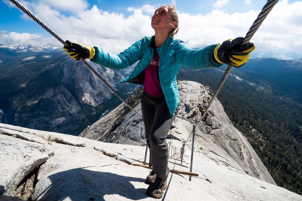
Yosemite National Park, particularly Yosemite Valley, is best known as the birthplace of American climbing. Rock climbing in Yosemite is world-renowned, and many would argue that Yosemite is the planet’s premier rock climbing destination, where some of Earth’s grandest, most accessible freestanding rock formations and continuous walls are littered with nearly 3,000 routes. The climbs that Yosemite is best known for are the big wall, traditional routes on the park’s iconic formations, like El Cap and Half Dome, but there are also famous boulder problems (Midnight Lightning, V8), sport routes, and alpine climbs.

The vast majority of Yosemite climbs are in Yosemite Valley or Tuolumne Meadows, but there are several other areas, like Hetch Hetchy and Wawona. The most famous routes in the park include The Nose (VI 5.9 C2 3,000’) and Freerider (VI 5.13a PG-13 3,300’) on El Capitan, Astroman (IV 5.11c 1,000’) on Washington Column, Snake Dike (III 5.7 R 2,000’), a heavily runout but mellow route up Half Dome, and the Southeast Buttress of Cathedral Peak (II 5.6 700’).
Yosemite is also home to the world’s hardest big wall climb, The Dawn Wall (VI 5.14c 2,500’), freed by Tommy Caldwell and Kevin Jorgeson in 2015.
NOTE: Wilderness climbing permits are now required for overnight big wall climbs. Camping at the base of any wall in Yosemite is also illegal, except for Half Dome, which requires a permit. For more information on rules and regulations on rock climbing in Yosemite, see the National Park Service website or check out our dedicated guide to Yosemite rock climbing.

There are 800 miles (1,300 km) of hiking trails within Yosemite National Park, and the landscape is a veritable trekking paradise. Here are some of the best options:
The Yosemite Falls Trail starts from Camp 4 and takes you to a fantastic viewpoint of El Capitan (7,779 ft/2,371 m) and the falls themselves. This 7.2-mile (11.5 km) out-and-back trip is moderately strenuous as it gains some 2,700 feet (823 m) to the viewpoint. If you’re looking to top out on El Cap itself, you can connect onto a spur trail to the summit of Yosemite’s most dramatic feature for a 15-mile (24 km) round-trip adventure.

Perhaps the most sought-after hike in Yosemite National Park, the trail up Half Dome (8,839 ft / 2,694 m) follows the Cable Route to the summit of the most iconic feature in the area. This hike is so popular that you must enter a permit lottery up to 6 months ahead of time, but if you want a chance to see some of Yosemite Valley’s best views, it’s worth a shot!
Located in the Hetch Hetchy region, the Rancheria Falls Trail is a 13.4 mile (21.4 km) out-and-back hike that begins at O’Shaughnessy Dam and takes you past Wapama Falls to the spectacular waterfalls at Rancheria. The falls can be done as a day hike, but if you want to spend the night in the backcountry, you’ll need to apply for a wilderness permit!

A short 0.3-mile (0.5 km) loop around the Mariposa Grove of giant sequoia, this hike isn’t strenuous at all, but it is your best way to experience the splendor of the giant sequoia trees firsthand. Plus, it’s wheelchair accessible and relatively flat, so it’s perfect for families.
Just an hour and a half south of Yosemite National Park, Fresno is the sixth-largest California city with all the usual amenities and a large airport. Plus, you can take the YARTS public transport system straight from town into the park if you’re traveling without a car or don’t want to drive in the traffic.

Located an hour and a half southwest of Yosemite National Park, Merced is a city of 80,000 people with plenty of hotels, restaurants, and shops to resupply at before your adventures. You can also take the YARTS public transport system straight from Merced to Mariposa and Yosemite National Park all year long.

If you want to stay in Yosemite National Park, you can stay in one of the park’s lodging options or campgrounds. As you can imagine, these places are incredibly popular, and you’ll definitely want to make a reservation in advance. Campground reservations are available up to six months ahead, but check out the park’s website and recreation.gov for more information.


13er
western-state-climbers
western-state-climbers-star
sierra-club-sierra-peaks-section
sierra-peaks-section-emblem
sierra-sampler
vagmarken-sierra-crest
13er
western-state-climbers
western-state-climbers-star
sierra-club-sierra-peaks-section
sierra-sampler
vagmarken-sierra-crest
13er
western-state-climbers
western-state-climbers-emblem
vagmarken-sierra-crest
western-state-climbers
western-state-climbers-emblem
sierra-club-sierra-peaks-section
vagmarken-sierra-crest
western-state-climbers
western-state-climbers-emblem
sierra-club-sierra-peaks-section
vagmarken-sierra-crest
western-state-climbers
western-state-climbers-star
sierra-club-sierra-peaks-section
sierra-sampler
vagmarken-sierra-crest
western-state-climbers
western-state-climbers-emblem
sierra-club-sierra-peaks-section
sierra-sampler
vagmarken-sierra-crest
western-state-climbers
western-state-climbers-star
sierra-club-sierra-peaks-section
sierra-sampler
vagmarken-sierra-crest
13er
western-state-climbers
western-state-climbers-star
sierra-club-sierra-peaks-section
sierra-sampler
vagmarken-sierra-crest
western-state-climbers
western-state-climbers-star
sierra-club-sierra-peaks-section
sierra-peaks-section-mountaineers
sierra-sampler
vagmarken-sierra-crest
western-state-climbers
western-state-climbers-star
sierra-club-sierra-peaks-section
vagmarken-sierra-crest
13er
western-state-climbers
western-state-climbers-emblem
vagmarken-sierra-crest
13er
western-state-climbers
western-state-climbers-star
sierra-club-sierra-peaks-section
sierra-peaks-section-emblem
sierra-sampler
vagmarken-sierra-crest
western-state-climbers
western-state-climbers-star
sierra-club-sierra-peaks-section
sierra-peaks-section-emblem
sierra-sampler
vagmarken-sierra-crest


