Scan the QR code and open PeakVisor on your phone
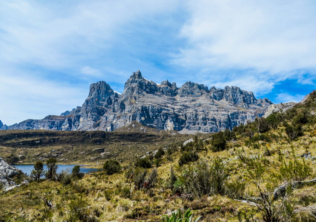
Indonesia, or the Republic of Indonesia (Republik Indonesia), is the largest country in Southeast Asia and the 14th largest country globally, covering an area of around 1,904,569 sq km (735,358 sq mil). It's a remarkable natural destination, home to volatile volcanoes, sublime waterfalls, pristine breaches, and dense rainforests. There are 27886 named mountains in Indonesia. Puncak Jaya (4,884 m / 16,024 ft) is the highest and most prominent mountain.
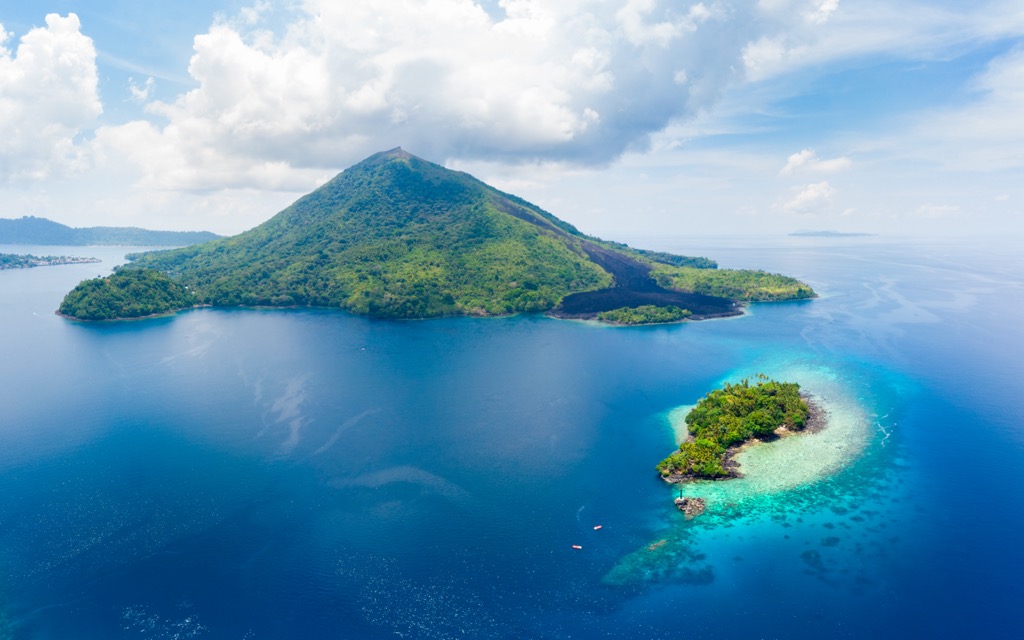
Over 17,500 islands comprise Indonesia, including the world's most populated island, Java, and the western portion of the world's second-largest island, New Guinea. Many of these islands are merely rocky outcroppings; of the total, about 9,000 islands are named, and 900 are permanently inhabited. Indonesia separates the Indian and Pacific Seas and forms part of the world's largest archipelago, the Malay Archipelago.
Despite consisting primarily of islands, Indonesia has land borders with three countries: Malaysia on Borneo and Sebatik, Papua New Guinea on New Guinea, and East Timor on Timor. Additionally, Indonesia shares maritime borders with five other countries: Australia, the Philippines, Vietnam, Singapore, and Palau.
Indonesia is home to 54 national parks and 6 World Heritage Sites. Notable national parks in Indonesia include Bromo Tengger Semeru National Park, West Bali National Park, Komodo National Park, and Ujung Kulon National Park.
The Greater Sunda is a group of Indonesia’s four largest islands: Borneo, Sumatra, Java, and Sulawesi. Most of these islands are Indonesian territory, with only the northern quadrant of Borneo belonging to other countries (Malaysia and Brunei).
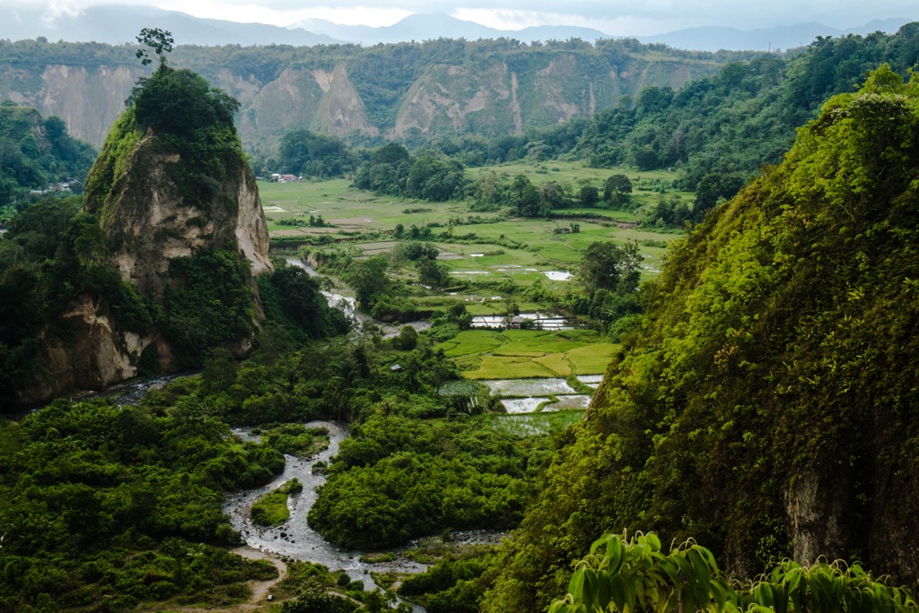
The westernmost of the Greater Sunda Islands is Sumatra, the largest island entirely within Indonesia and the sixth-largest island globally. It encompasses an area of 475,807 sq km (182,812 sq mi) and is carpeted by rainforests. The 1,700 km (1,050 mi) long Barisan Mountains run down the spine of Sumatra.
Sumatra's Gunung Kerinci (3,805 m / 12,484 ft) is the highest volcano in Indonesia. Lake Toba in North Sumatra is Indonesia's largest lake, with a surface area of 1,130 sq km (440 sq mi).
Just to Sumatra's southeast is Java, home to 56% of Indonesia's population and its capital, Jakarta. Java covers an area of roughly 124,413 sq km (48,036 sq mi), and its main geographical features are rainforests, highlands, and volcanos. Gunung Semeru (2,639 m / 8,658 ft) is Java’s highest mountain.
Indonesia's central island, Borneo, covers 748,168 sq km (288,869 sq mi) and is the third-largest island globally. Around 73% of Borneo is part of Indonesia. Samarinda is Borneo's largest city, with over 725,000 people. The island is famed for its extensive rainforests and biodiversity.
Sulawesi, also known as Celebes, is the easternmost of the Greater Sunda Islands. It's the third-largest of the Greater Sunda Islands, with an area of approximately 186,216 sq km (71,898 sq mi). The island consists primarily of four peninsulas separated by three bays. Its interior is rugged and mountainous, with several active volcanoes in Northern Sulawesi, including Gunung Tangkoko (1,113 m / 3,652 ft), Gunung Lokon (1,146 m / 3,760 ft), and Mount Awu (1,331 m / 4,367 ft).
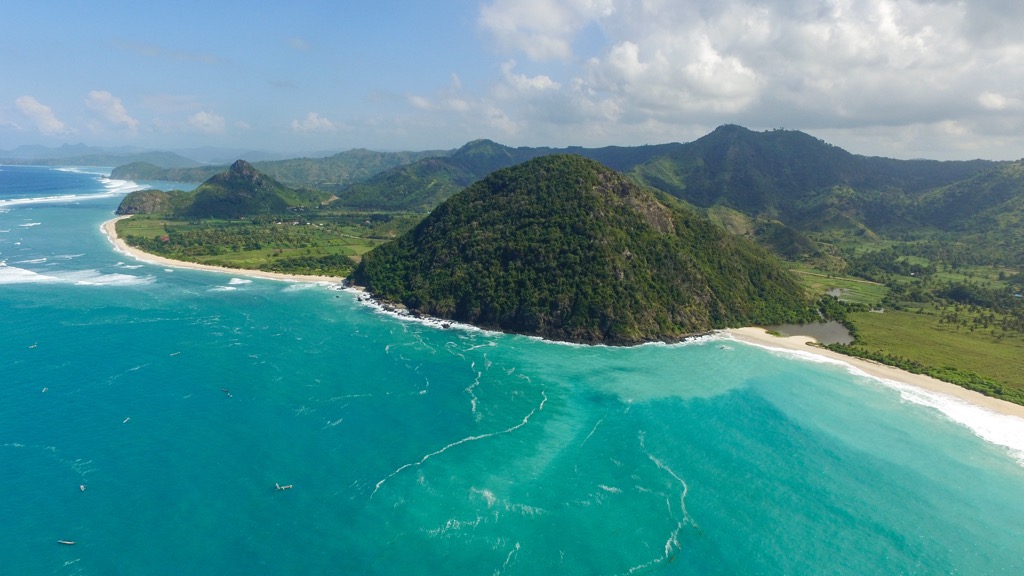
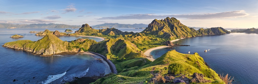
The Lesser Sunda Islands form a linear archipelago east of Java and are part of the Sunda Volcanic Arc. The archipelago consists of 12 main islands and island groups. From east to west, these islands are the Tanimbar Islands, the Barat Daya Islands, the Alor Archipelago, Atauro, Timor, Rote, Savu, Sumba, Flores, Sumbawa, Lombok, and Bali.
Approximately 20 million people inhabit the Lesser Sunda Islands. Bali, which sits less than 2.5 km (1.5 mi) off the west coast of Java, has the highest population, with over 4.4 million people.
The Lesser Sunda Islands are mainly of volcanic origin and are primarily mountainous. Large areas of rainforest and deciduous forest carpet the archipelago. Lombok's Gunung Rinjani (3,725 m / 12,224 ft) is the second-highest volcano in Indonesia.
The second-largest island in the world, New Guinea, is split between the country of Papua New Guinea to the east and Western New Guinea (Western Papua), which is part of Indonesia. Western New Guinea encompasses an area of 412,214 sq km (159,156 sq mi), just over half of New Guinea. Western New Guinea accounts for 22% of Indonesia's total area.
Western New Guinea has a population of around 5.4 million people. The largest city is Jayapura, with a population of over 360,000 people. The region is mountainous, with the 690 km (428 mi) long Maoke Mountains running from west to east. They form a part of the New Guinea Highlands.
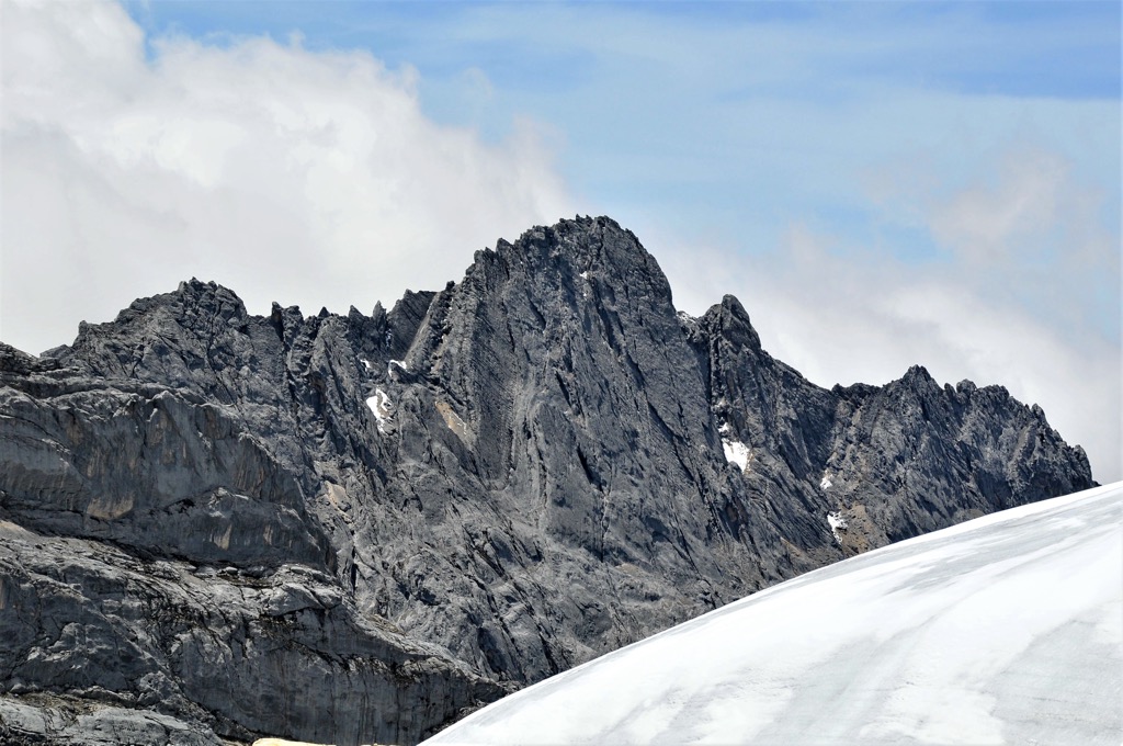
The Maoke Mountains notably include Indonesia's highest summits: Puncak Jaya, Sumantri (4,870 m/15,978 ft), and Ngga Pulu (4862 m/15,951 ft). To the north and west of the New Guinea Highlands are also mountains, with swamps and fertile alluvial plains to the south.
The Maluku Islands, also called the Moluccas, is an archipelago between Sulawesi and New Guinea in eastern Indonesia. The archipelago comprises 1,027 islands with a total area of around 85,000 sq km (32,818 sq mi).
Halmahera is the largest of the Maluku Islands, with an area of 17,780 sq km (6,860 sq mi). Ambon and Ternate are small but heavily populated — Ambon has the highest population, with over 470,000 people.
Most of the Maluku Islands are hilly and forested. Exceptions include the flat and marshy Aru Islands and the arid Tanimbar Islands. The island of Seram's Gunung Binaiya (3,026 m/9,931 ft) is the highest mountain on the Maluku Islands.
Indonesia's location at the meeting point between several tectonic plates makes its geology highly complex. It's between two tectonic plates: the Sahul Shelf of the Australian Plate and the minor Sunda Plate. It's also between two ocean plates: the Philippines Sea Plate and the Pacific Plate.
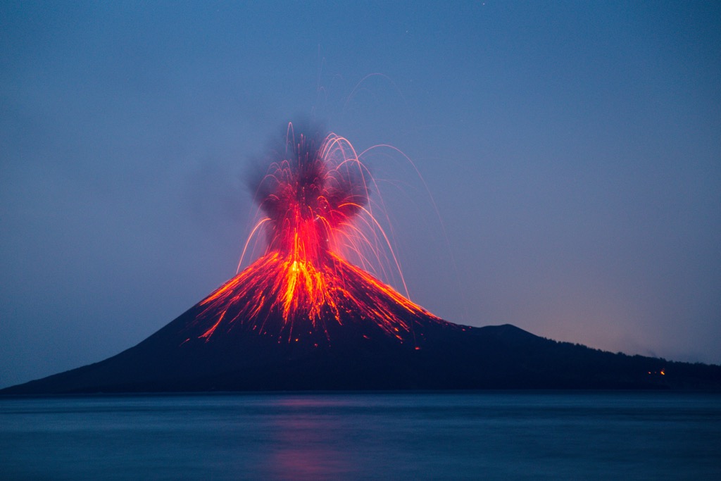
Due to its position, Indonesia is highly geologically unstable. Earthquakes and volcanoes are common across the country. There are roughly 400 volcanoes in Indonesia, 130 of which are active. Its volcanic activity is due to its position in the Ring of Fire, formed by the subduction of the Australian Plate and Pacific Plate under the Eurasian Plate.
In April 1815, the eruption of Mount Tambora released enough atmospheric dust that it cooled the climate by about 1 degree Celsius, triggering crop failures and famine worldwide. The following year, 1816, was known as the ‘year without a summer’ due to the abnormally cold temperatures throughout North America and Europe.
Over the 20 years from 1972 to 1991, 29 volcanoes erupted in Indonesia. Gunung Merapi (2,955 m / 9,695 ft) in Central Java is Indonesia's most active volcano, having erupted regularly since 1548, including five times since 2006.
The Sunda Arc is a volcanic arc in western Indonesia formed by the ongoing subduction of the Indian Plate underneath the Sunda and Burma plates at a rate of up to 70 mm per year.
The Sunda Arc stretches from Sumatra through Java, ending at Flores. It's one of the world's most seismically and volcanically active regions and the site of the devastating 9.15 magnitude earthquake and subsequent tsunami in December 2004.
The 1883 eruption of Krakatoa (Krakatau) (209 m / 686 ft) in the Sunda Strait was one of the most violent and destructive ever recorded. The eruption could be heard on the island of Rodrigues near Mauritius, roughly 4,800 km (2,982 mi) away.
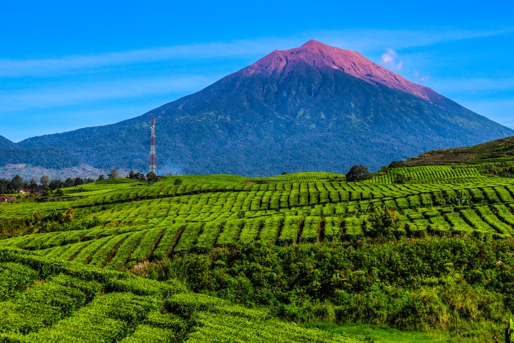
Modern-day Indonesia has been shaped by millions of years of volcanic and seismic activity, with many volcanic mountain ranges spread across the archipelago. Aside from Indonesia's highest summits, notable mountains include Gunung Agung (3,030 m / 9,944 ft), Gunung Bromo (2,329 m / 7,641 ft), and Gunung Ijen (2,346 m / 7,697 ft).
A vast tropical archipelago, Indonesia is the second most biologically diverse country globally after Brazil.
The sheer scale of Indonesia's biodiversity means it is split into several distinct biogeographical regions.
The Sundaland region of Indonesia, which includes Borneo, Sumatra, and Java, is incredibly biodiverse. Sundaland was connected to the Asian mainland during the Ice Age, allowing many large mammals to migrate to the islands.
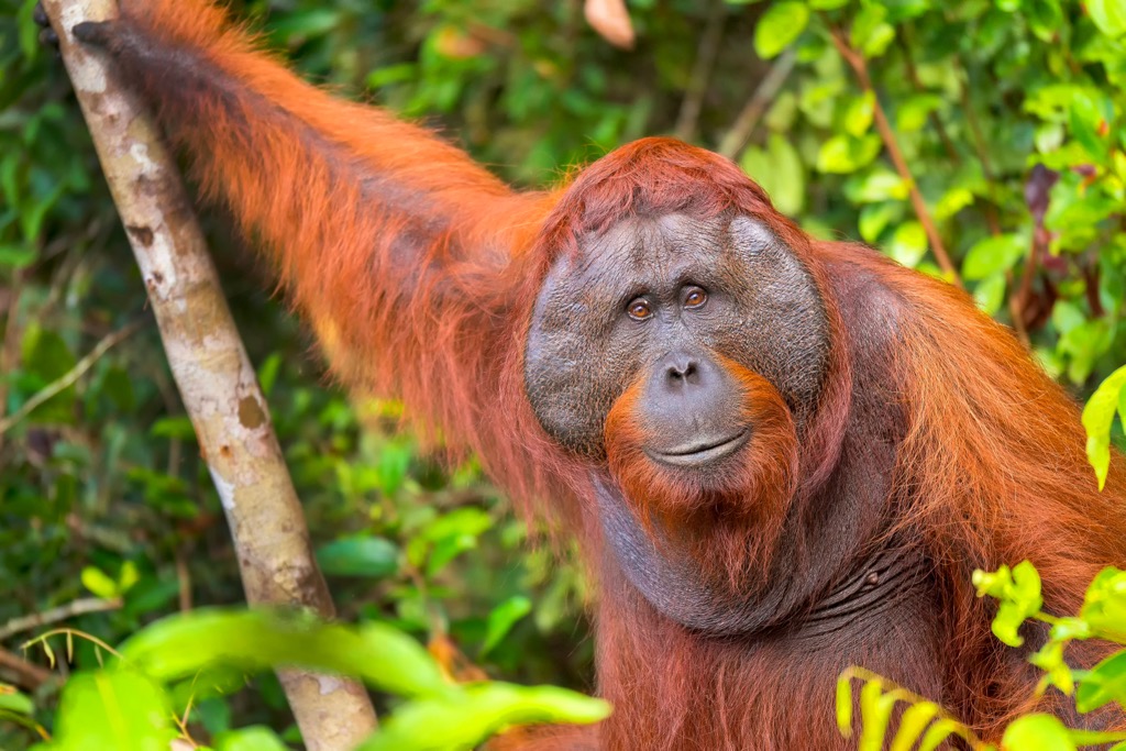
Over 380 mammal species inhabit Sundaland, including Bornean elephants, Sumatran orangutans, Sumatran rhinoceros, and Sumatran tigers.
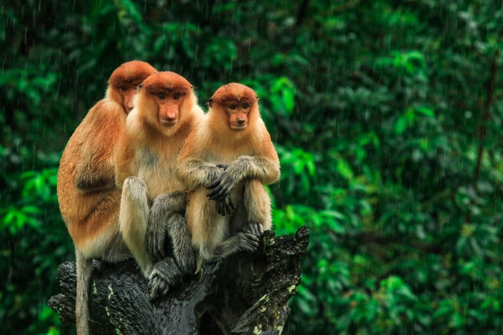
Around 170 of Sundaland's mammals are endemic, with the highest percentage in Borneo. Notable examples include proboscis monkeys, pig-tailed langurs, and Javan rhinos. Javan rhinos are among the most endangered mammals globally, with a population numbering fewer than 75.
Of the 770 bird species in Sundaland, around 150 are endemic. Notable birds include endangered Bali mynas, Javan plovers, Javan hawk-eagles, and Bali starlings.
Sundaland is home to around 450 reptile species and 240 amphibian species. Notable species include false gharials, Bornean earless monitors, painted terrapins, and slender toads.
Around 1,000 freshwater fish inhabit Sundaland's lakes and rivers. The most famous of which is the prized and endangered golden arowana.
Wallecea encompasses the eastern half of Indonesia, including Sulawesi, Lombok, Flores, and Timor. Over 220 mammals inhabit Wallacea, over half of which are endemic. Anoas, a dwarf buffalo species, and babirusas, also known as deer-pigs, are two of Wallacea's most unusual mammal species.
Roughly 650 bird species are found in Wallacea, with 265 endemic species. Most live on Sulawesi, such as maleos, Sulawesi mynas, and Sulawesi ground doves.
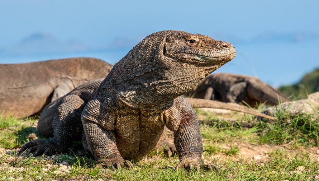
There are 222 lizard species and 58 amphibian species in Wallacea. Wallacea's most famous endemic animal is the Komodo dragon, the largest lizard species on the planet. This apex predator is found only on Komodo, Padar, Rinca, and Flores.
Wallacea has incredibly high insect and invertebrate biodiversity, with 44 endemic birdwing butterfly species and 79 endemic tiger beetle species. The northern Maluku Islands are home to the world's largest bee, Wallace's giant bee, which has a wingspan of 2.5 inches.
New Guinea, on the western edge of the Australian continent, is home to many mammals, especially marsupials and monotremes, such as Goodfellow's tree-kangaroos, Sir David's long-beaked echidnas, and bronze qualls.
Around 730 bird species nest in New Guinea, including vibrant species like greater birds of paradise, Papuan hornbills, and southern cassowaries.
There are roughly 320 amphibian and 300 lizard species in New Guinea. Notable examples include saltwater crocodiles, Parker's snake-necked turtles, and Wokan cannibal frogs.
Part of the Coral Triangle, New Guinea is one of the most biologically rich marine regions globally, home to over 2,200 fish species. Roughly 375 freshwater fish swim in New Guinea's waters, including glassfish, rainbowfish, blue-eyes, and gobies.
Indonesia's plant life biodiversity more than matches its fauna, with notably different flora found across the regions of Sundaland and Wallacea. Melati putih, a small white flower with a sweet fragrance, is the national flower of Indonesia.
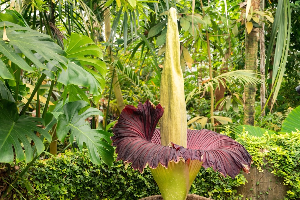
Over 25,000 plant species grow across Sundaland, and around 15,000 are endemic. One of the most famous Indonesian plants is the titan arum. Also known as the corpse plant, it's renowned for its rotting flesh-like odor and large size. Titan arum can grow over 3 m (10 ft) high and weigh over 50 kg (110 lb).
Borneo has the most diverse plant life in Sundaland, with over 150 Dipterocarpus species and 2,000 orchid species. Java also boasts many endemic orchid species, numbering around 270. There are 59 endemic plant genera in Borneo and 17 in Sumatra.
Sundaland also has a diverse tree population, with over 3,000 species. Sixteen Rafflesia species, a flower genus, grow in Sundaland. The critically endangered Rafflesia arnoldii, or giant padma (nicknamed ‘stinking corpse lily’ due to its scent), is one of the largest flowers globally, growing up to 1 m (3.2 ft) in diameter.
Approximately 10,000 plant species are spread across Wallacea, 15% endemic. Additionally, there are 12 endemic genera. Most of these endemic plants are found in Sulawesi, with around 500 species present. Meanwhile, the Maluku Islands have about 300 endemic species.
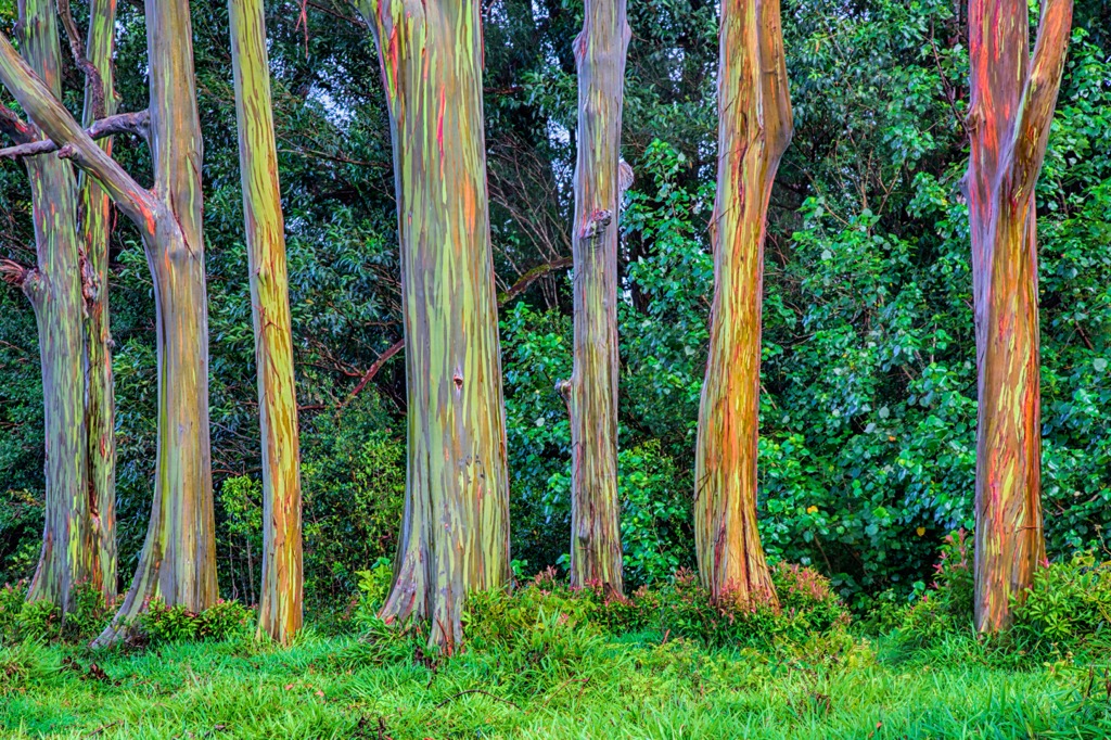
Wallacea flora is diverse but not well studied. Notable examples of vascular plants in Wallacea include rainbow eucalyptuses, kauri trees, and Malay padauks.
New Guinea's varied landscapes and position on the edge of Australia means it has highly diverse flora, with over 7,600 species occurring on the Indonesian side of the island. As many as 90% of New Guinea's flora species are endemic. The island’s wildlife is not yet well documented, so the exact number of endemic species is unclear.
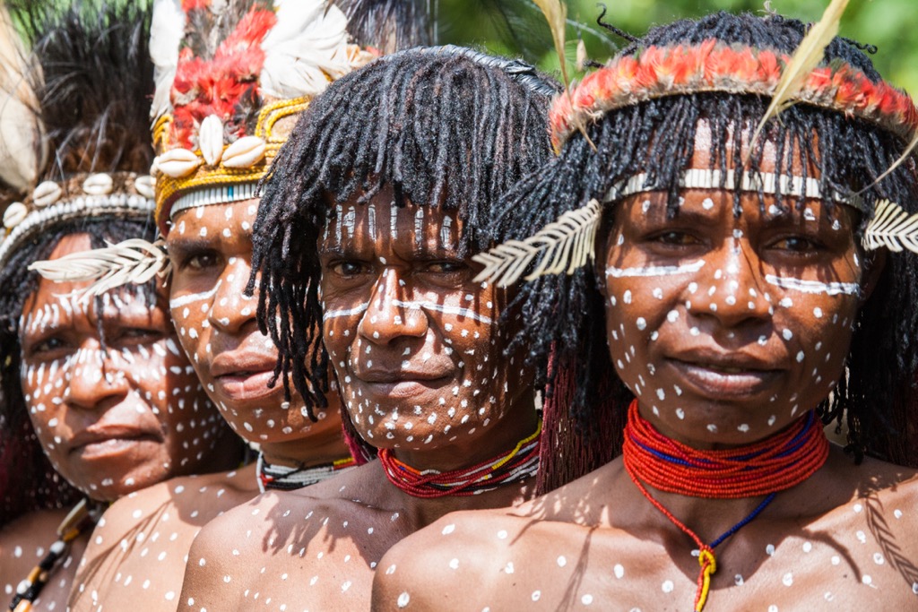
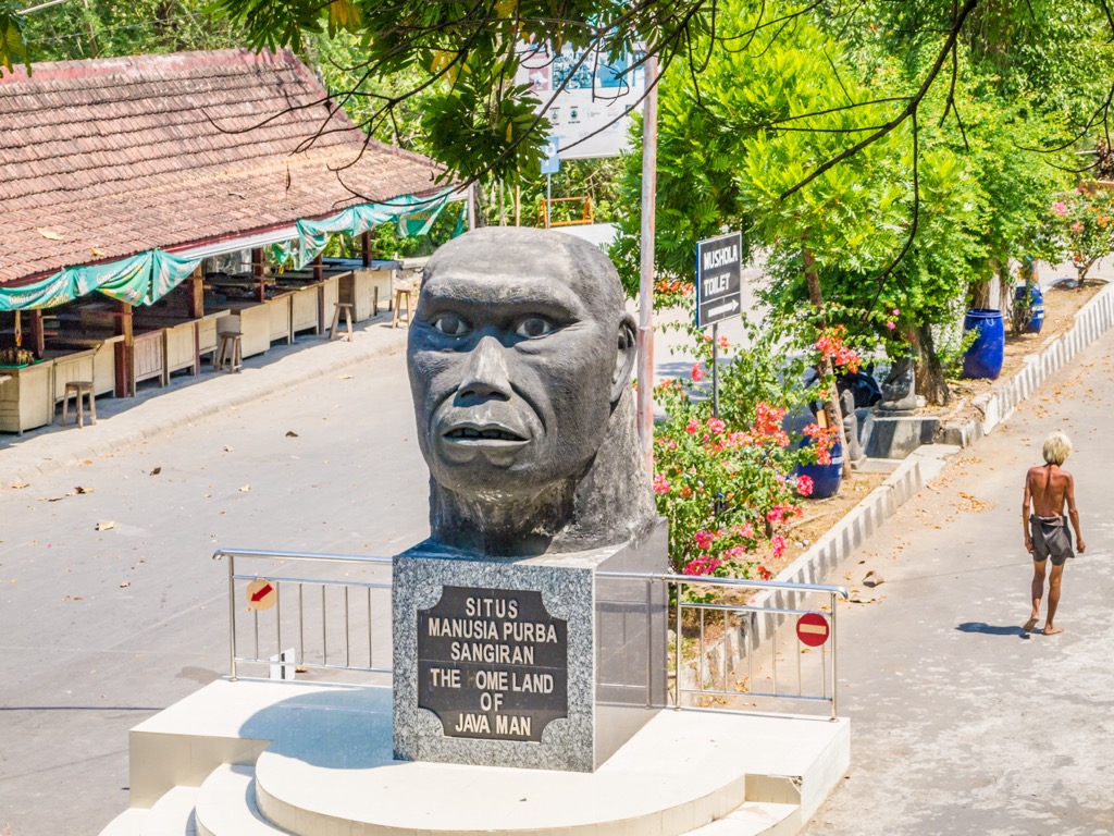
The earliest recorded evidence of humans in Indonesia is the fossilized remains of the "Java Man." Discovered in the 1890s in Sangiran, Java, the "Java Man" is believed to date back at least 700,000 years. The “Java Man” was the oldest Homo erectus remains ever discovered at the time. Archeologists have also found evidence of clamshell tools that date back over 1.4 million years in Indonesia.
Indian culture heavily influenced Indonesia in its early history. As early as 200 BCE, there are references to Yawadvipa, the Hindu kingdom of Java and Sumatra, written in Sanskrit.
Several Hindu and Buddhist states were founded by the seventh century. Early important examples include the Tarumanagara Kingdom, the Mataram Empire, and the Srivijaya.
By the seventh century, Islam had become the dominant religion in Sumatra, subsequently spreading across most of Indonesia. Bali was the only island that remained predominantly Hindu. During this period, Indonesia became very successful at maritime trading due to its strategic position between continents. The original spread of Islam resulted from the arrival of Muslims involved in the spice trade.
Several Islamic kingdoms, known as sultanates, were established in Indonesia until the eighteenth century. Notable examples include the Sultanate of Mataram, the Demak Sultanate, and the Sultanate of Banten.
By the sixteenth century, Europeans had begun arriving in Indonesia, looking for ways to strengthen their positions in the highly profitable spice trade. Around this time, Christian missionaries began arriving in Indonesia. The country still retains a significant Christian population.
Portugal was the first country to colonize Indonesia. They initially turned their attention to the "spice islands" of Maluku, establishing trading posts, forts, and Catholic missions through local alliances and military conquests.
The Portuguese were most active in the late sixteenth century, but their influence waned following defeats to local tribes and the Dutch. Despite aims to dominate Indonesian trade, Portugal's influence was relatively small.
The Dutch had the most significant colonial influence on Indonesia, starting with the Dutch East-India Company (VOC) in the early 1600s. They built the city of Batavia (modern-day Jakarta) and were more successful than the Portuguese at controlling trade.
The VOC was dissolved in 1800 following the fall of the Netherlands to the First French Empire. During this time, the East Indies were a puppet colony of France under the new Kingdom of Holland. In 1811, the British Empire captured Java. At the end of the Napoleonic Wars, Indonesia was returned to the Dutch under the Anglo-Dutch Treaty of 1814.
The return of Dutch rule saw the introduction of forced labor and a rigid caste system. The Netherlands introduced somewhat more liberal laws in 1901.
Dutch rule of Indonesia ended following the Japanese occupation of the islands during the Second World War. In 1945, two days after Japan surrendered, the Indonesian nationalist leader Sukarno declared independence.
The Dutch attempted to return to power in Indonesia, but the Indonesian National Revolution resulted in widespread international condemnation. The Dutch abandoned their attempts to regain control of Indonesia in 1949.
The violent Bersiap period of the revolution resulted in the deaths of 3,500 Europeans, with another 20,000 missing. More Europeans died in Indonesia during the Bersiap period after the Second World War than during it. Indonesia was united on 17 August 1950 as the current Republic of Indonesia with Sukarno as president.
In 1965, an attempted coup by the Indonesian Army targeting high-ranking Communist Party of Indonesia (PKI) officers saw over half a million people killed and the disbandment of the PKI. It ended with the ousting of Sukarno, the transition to the New Order, and the start of Army General Suharto's 32-year dictatorship.
Suharto's dictatorship is considered one of the most cruel and corrupt of the twentieth century. This rule saw the annexation of West New Guinea and East Timor. Pro-democracy movements, riots, and the 1997 Asian financial crisis contributed to Suharto's resignation in 1998.
Suharto's resignation led to independence for East Timor. Since 1999, Indonesia has democratically elected its leaders. Indonesia has a rapidly growing economy based on petroleum and natural gas exports, agriculture, and tourism.
Indonesia's volcanic landscape and diverse wildlife make it one of Southeast Asia's best hiking destinations.
You'll need a permit to enter some of Indonesia's protected areas. This permit is called a Surat Ijin Masuk Kawasan Konservasi (SIMAKSI) and can be obtained online or through the local area manager. Both foreign visitors and Indonesian citizens require this permit. You may also need a health certificate for permission to climb some of Indonesia's most challenging mountains.
Bring hiking equipment appropriate for where you are in Indonesia. A raincoat is a necessity, even during the dry season. Bring good hiking boots, a handheld GPS, and plenty of food and water. Hike in groups when possible and inform others of your intended itinerary.
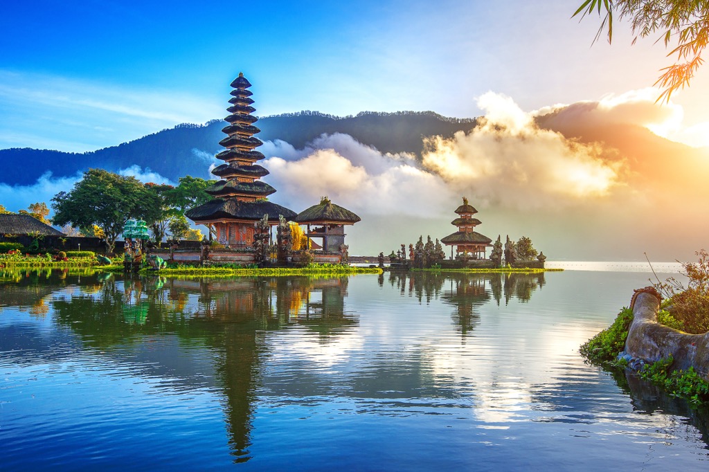
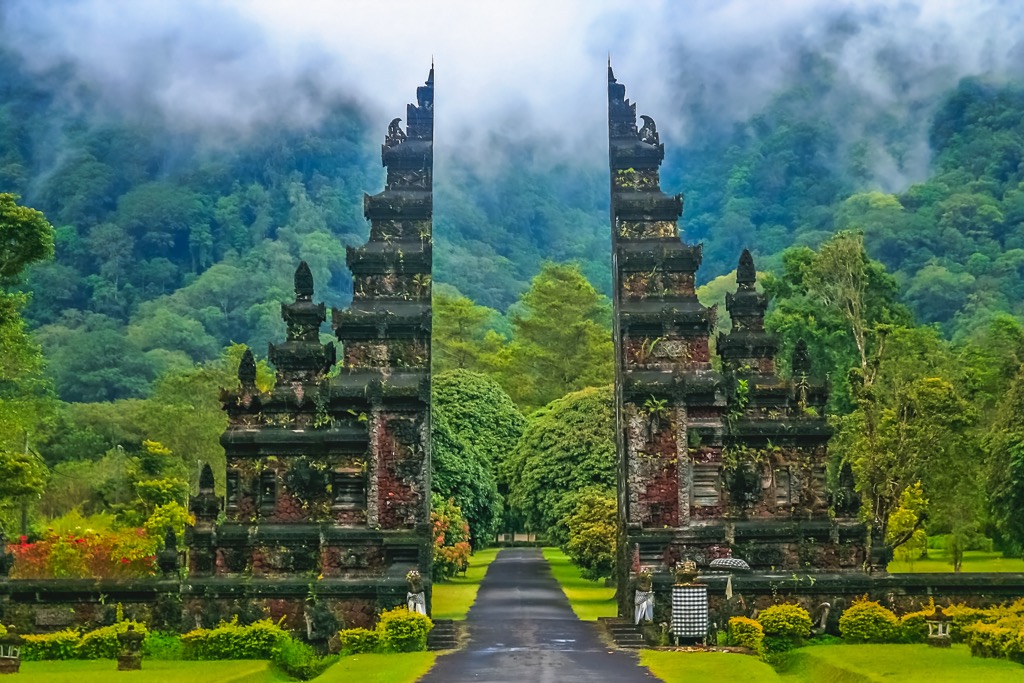
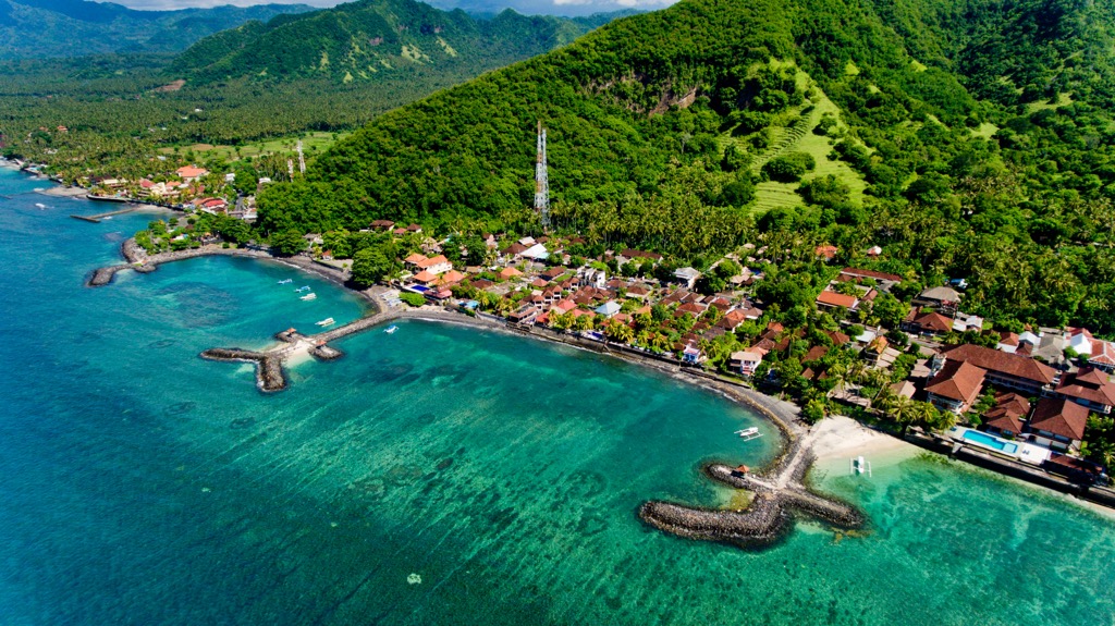
The westernmost of the Lesser Sunda Islands, Bali is Indonesia's most popular tourist destination. It's easy to see what draws millions of tourists to the island, with its pristine beaches and lush rainforests. Bali is also an excellent hiking destination, boasting some of Indonesia's most popular mountains.
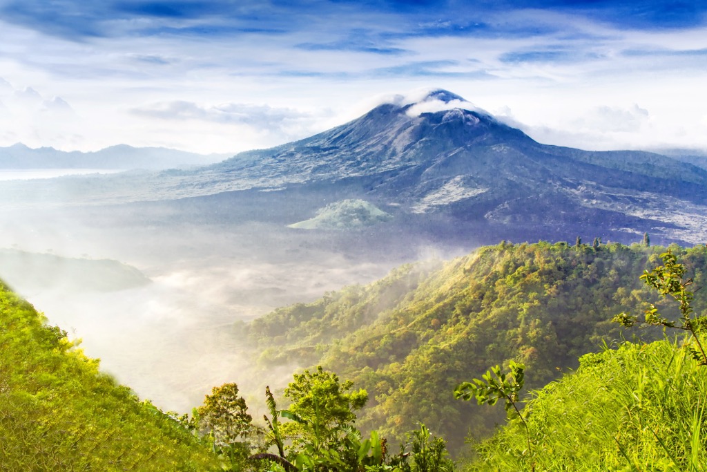
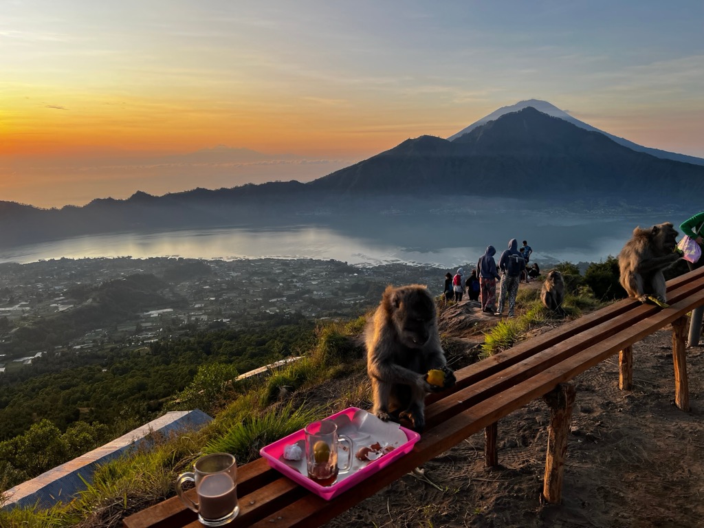
Gunung Batur (1,717 m / 5,633 ft) is an active volcano in northeastern Bali and one of the island's most famous mountains. It's a unique volcano due to its two concentric calderas, with the outer caldera containing Danau Batur Lake. You'll have one of the best views of Gunung Agung (3,031 m / 9,944 ft) to the southeast from the summit.
The best time of day to climb Gunung Batur is in the early morning so you can catch the sunrise from the summit. You can pick up the trail to Gunung Batur from near Toya Devasya to the summit's southeast. This out-and-back trail is approximately 9.5 km (6 mi) in length.
Or, consider scaling Gunung Agung if you're searching for a more challenging trek in Bali. Bali's highest and most sacred mountain, Gunung Agung, is an active stratovolcano with a deep crater. It last erupted between 2017 and 2019. It's a steep mountain with rock climbing needed in some places — hiring a guide is highly recommended.
You can pick up the trail to Gunung Agung from the Pura Pasar Agung Hindu temple. From the summit of Gunung Agung, it's possible to see Gunung Rinjani on the island of Lombok. This out-and-back trail is approximately 7.5 km (4.6 mi).
Bali's other popular mountains and summits include Gunung Abang (2,272 m / 7,454 ft), Gunung Tapak (1,910 m / 6,266 ft), and Munduk Madeg (1,263m / 4,144 ft).
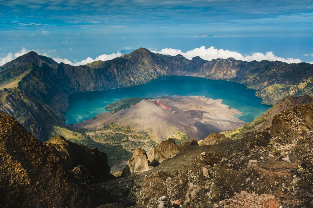
The 410 sq km (158 sq mi) Mount Rinjani National Park (Taman Nasional Gunung Rinjani) is on Lombok in the Lesser Sunda Islands. The park centers around Gunung Rinjani (3,725 m / 12,224 ft), Indonesia's second-highest volcano after Sumatra's Gunung Kerinci (3,805 m / 12,484 ft). Gunung Rinjani's most recent eruption was in 2016.
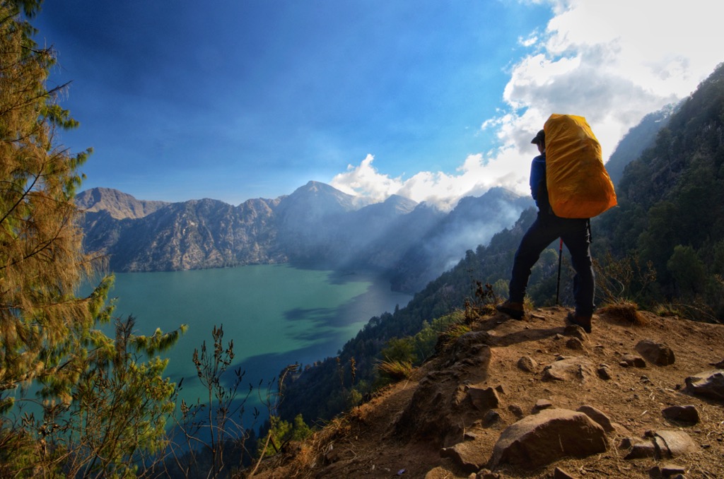
The trek up Gunung Rinjani is lengthy and requires high fitness levels. That said, the effort is well worth it for the stunning views of the nearby Bali and Sumbawa on a clear day. The view of the crater's Lake Segara Anak is also breathtaking.
The most popular route to Gunung Rinjani is a multi-day trek from Sembalun Lawang. The trail leads through rainforests, past waterfalls, and along the edge of Lake Segara Anak. This point-to-point trail is approximately 36.5 km (22.6 mi) in length.
Mount Rinjani National Park is famed for its waterfalls, the best of which is Air Terjun Sindang Gila. Located near Senaru village, Air Terjun Sindang Gila cascades for over 30 m (98 ft) in the middle of an idyllic rainforest. You can reach the waterfall on a leisurely 1 km (0.6 mi) walk from Senaru.
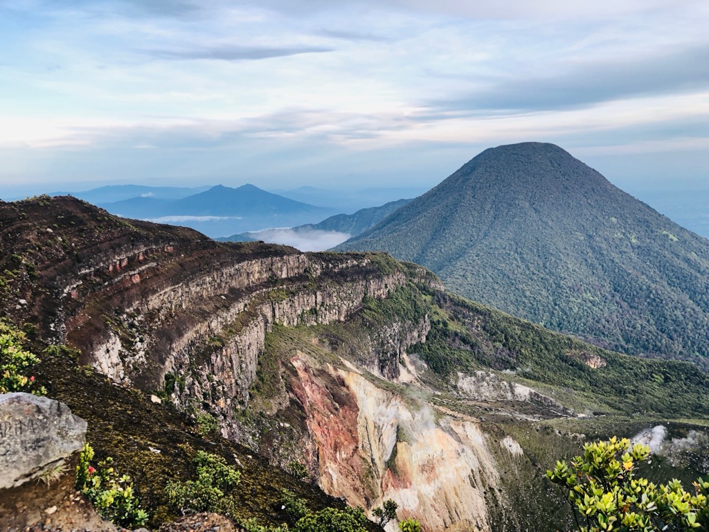
Ijen Merapi Ungup-Ungup Caldera Nature Reserve (Cagar Alam Kaldera Ijen Merapi Ungup-Ungup) centers around the Ijen volcanic complex in East Java. The highest volcano in the complex is Gunung Merapi (2,955 m / 9,695 ft), famed for being the most active volcano in Indonesia.
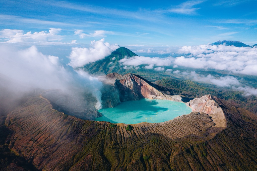
To the west of Gunung Merapi is the park's namesake, Gunung Ijen (2,346 m / 7,697 ft). Gunung Ijen is a unique volcano home to the world's largest acid lake at over 1 km (0.6 mi) in diameter.
High levels of sulfur have created a rare volcanic phenomenon, the api biru, or “blue fire.” Sulfur gas, emerging from the earth at upwards of 600 degrees Celsius, ignites on contact with the air, creating neon-blue flames. Iceland, Ethiopia, and Indonesia are the only places where these blue volcanic flames are visible. Observing this phenomenon has become hugely popular with tourists in recent years.
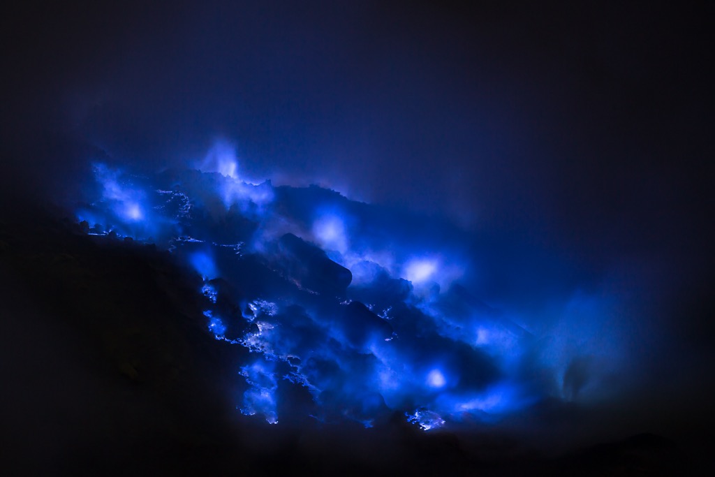
You can hike to the crater of Gunung Ijen from the Tourism Information Center Ijen Bondowoso to the southwest. The walk is rocky and steep in places. This out-and-back trail is approximately 9.5 km (6 mi) in length.
Located in Central Papua, Lorentz National Park (Taman Nasional Lorentz) is the largest national park in Southeast Asia, covering an area of approximately 25,056 sq km (9,674 sq mi).
Declared a UNESCO World Heritage Site in 1999, Lorentz National Park is one of the world's most biologically diverse areas. The park encompasses large parts of the Maoke Mountains, including the Sudirman Range, where Puncak Jaya (4,884 m/16,024 ft) is located.
Puncak Jaya is the highest mountain in Indonesia and the Australian continent. It's the lowest of the Seven Summits but is a highly technical mountain that you should only attempt if you're an experienced rock climber.
You should be prepared for last-minute changes to your itinerary while climbing Puncak Jaya. Tribal wars and the ongoing Papua conflict have destabilized the region around Lorentz National Park.
The Normal Route to Puncak Jaya is called the Harrer's Route. After reaching the Lake Valley Base Camp, it takes roughly 14 hours to reach Puncak Jaya's summit. The route involves a fixed rope climb up a 600 m (1,968 ft) rock face and a rappel off an overhanging wall, graded VI by the International Union of Alpine Associations (UIAA).
Mount Gede Pangrango National Park (Taman Nasional Gunung Gede Pangrango) is located in West Java and covers an area of roughly 150 sq km (58 sq mi). The park takes its name from twin stratovolcanoes: Gunung Gede (3,026 m / 9,928 ft) and Gunung Pangrango (3,019 m / 9,905 ft).
Biodiversity is high in Mount Gede Pangrango National Park — the park is home to over 250 bird species and endangered primates like silvery gibbons.
Gunung Gede is the most popular of the twin volcanoes. The paths to the summit are well-maintained, and it's suitable for casual hikers.
You'll enjoy sweeping views of Gunung Gede's seven craters and neighboring Gunung Pangrango from the summit. You can pick up the trail to Gunung Gede from the Basecamp Putri Gede Pangrango to the mountain’s northwest. This out-and-back trail is approximately 18 km (11 mi).
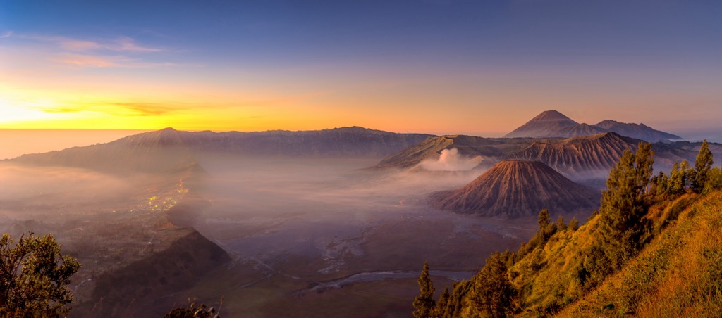
Bromo Tengger Semeru National Park is one of Indonesia's most unusual national parks. It's the country's only protected area to contain a sand sea. Out of the sand sea rises the Tengger massif, a complex of five volcanoes. The park covers an area of roughly 503 sq km (194 sq mi).

Gunung Bromo (2,329 m / 7,641 ft) isn't one of the highest volcanoes in the Tengger massif, but it's the most famous. Gunung Bromo is an active somma volcano with an impressive crater and is one of East Java's most popular tourist attractions.
Gunung Bromo is a straightforward trek and a popular place to watch the sunrise. You can hire a Jeep to take you to the summit if you want to avoid hiking. Check with the Indonesian Center for Volcanology and Disaster Mitigation before climbing, as they sometimes issue warnings due to volcanic activity.
You can pick up the trail to Gunung Bromo from Cemoro Lawang to the volcano's northeast. This trail loop is approximately 9.5 km (6 mi) in length.
Another worthwhile hike in Bromo Tengger Semeru National Park is Gunung Penanjakan (2,782 m / 9,127 ft). Situated just north of Gunung Bromo, Gunung Penanjakan offers some of the finest viewpoints in East Java.
Both King Kong Hill and Seruni Point provide breathtaking views of Gunung Semeru (3,676 m / 12,060 ft), Gunung Bromo, Gunung Batok (2,440 m / 8,005 ft), and Gunung Kursi (2,560 m / 8,399 ft).
Gunung Penanjakan is a relatively simple and popular hike. You can pick up the trail to Gunung Penanjakan from Cemoro Lawang. This out-and-back trail is approximately 10 km (6 mi) in length.
Mount Merbabu National Park (Taman Nasional Gunung Merbabu) encompasses an area of 57 sq km (22 sq m) in Central Java. The park's main feature is the dormant stratovolcano, Gunung Merbabu (3,145 m / 10,318 ft). Three main summits comprise Gunung Merbabu, the highest of which is Puncak Triangulasi.

Gunung Merbabu can be climbed from several directions, including from the west via Sunwatning and the northwest via Wekas. The official route is from Selo, starting from the Basecamp Merbabu Selo.
One of the best reasons to scale Gunung Merbabu is for the finest views of the highly active Gunung Merapi, 5 km (3 mi) to the south. This out-and-back trail is approximately 11 km (7 mi).
Steeped in Southeast Asian history and culture, Indonesia is home to some of Southeast Asia's finest towns and cities.

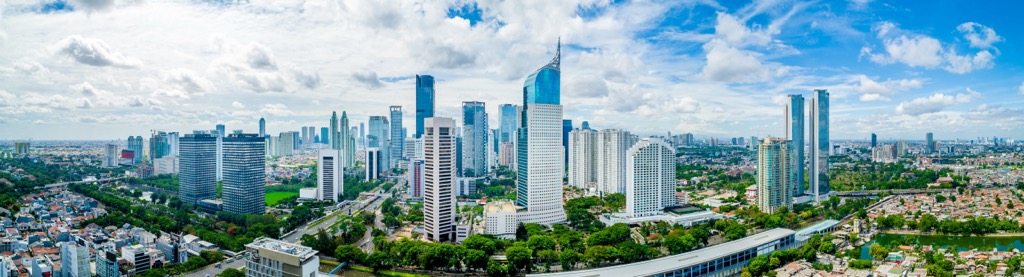
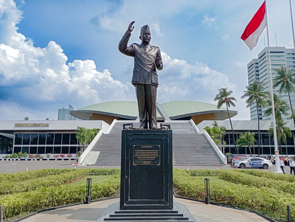
Perched on Java's northwestern coastline is the Indonesian capital, Jakarta. The largest metropolitan area in Southeast Asia, Jakarta is home to over 10 million people.
Jakarta is a bustling, vibrant city with attractions like the National Museum of Indonesia, Taman Impian Jaya Ancol, the National Monument, and the Jakarta Aquarium.
Indonesia's busiest airport, Soekarno–Hatta International Airport, is 31 km (19 mi) west of downtown Jakarta. Mount Gede Pangrango National Park is 110 km (68 mi) south of downtown Jakarta.
Surabaya is Indonesia's second city and the capital of East Java. Located on the northeastern coastline overlooking the Madura Strait, Surabaya is a historic city founded in the tenth century by the Kingdom of Janggala.

The Surabaya metro area has a population of nearly 10 million people. The city’s attractions include the Tunjungan Plaza, the Surabaya Submarine Monument, and the Sunan Ampel Great Mosque.
Bromo Tengger Semeru National Park is less than 120 km (74 mi) south of Surabaya. Juanda International Airport, Indonesia's third-busiest airport, is 20 km (12.5 mi) from downtown Surabaya.
Medan is Sumatra's capital and largest city. Located in North Sumatra, Medan is the largest metro area outside of Java. It's a significant financial hub home to over 2.4 million people.

Heavily influenced by Dutch colonialism and highly multicultural, Medan is known for its unique cuisine and literary heritage. Some of the top attractions in Medan include Tjong A Fie Mansion, Graha Bunda Maria Annai Velangkanni, and Centre Point Mall.
Kualanamu International Airport, Indonesia's fifth-busiest airport, is located 40 km (25 mi) east of downtown Medan.
Denpasar is the capital of Bali and Indonesia's tourism hub. Denpasar offers a mix of modern and traditional Balinese culture, history, and cuisine.
From the Werdhi Budaya Art Centre to Upside Down World Bali to the Turtle Conservation And Education Center, Bali has no shortage of attractions to keep you busy between hikes.

Denpasar is the best base from which to explore Bali's mountains. Gunung Batur is less than 65 km (40 mi) northeast of the city. I Gusti Ngurah Rai International Airport, Indonesia's second-busiest airport, is 15 km (9 mi) south of downtown Denpasar.