Share

Scan the QR code and open PeakVisor on your phone
Scan the QR code and open PeakVisor on your phone
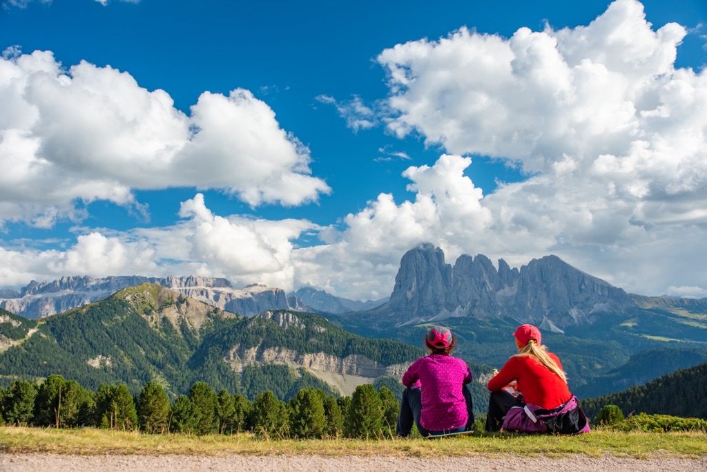
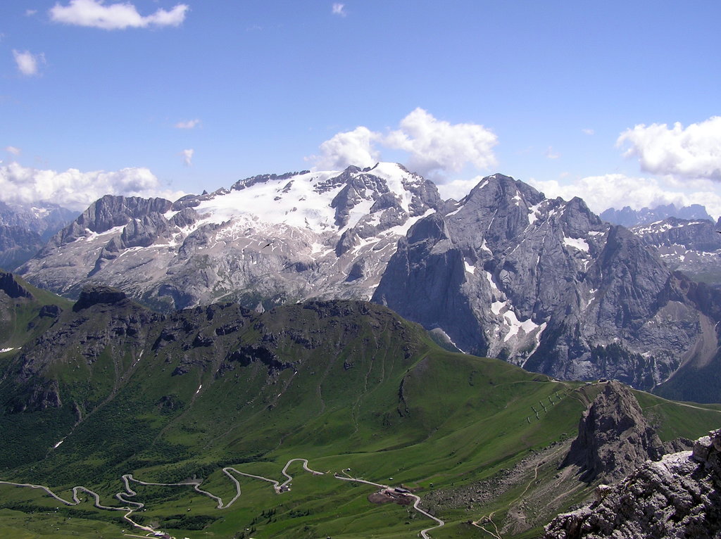
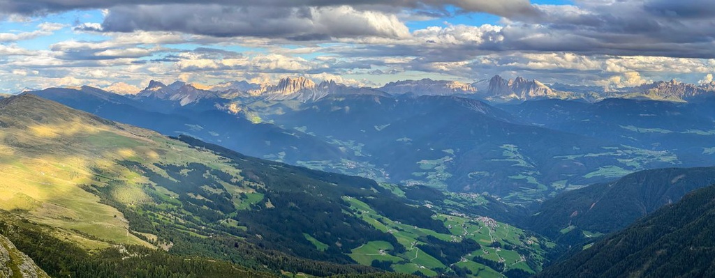
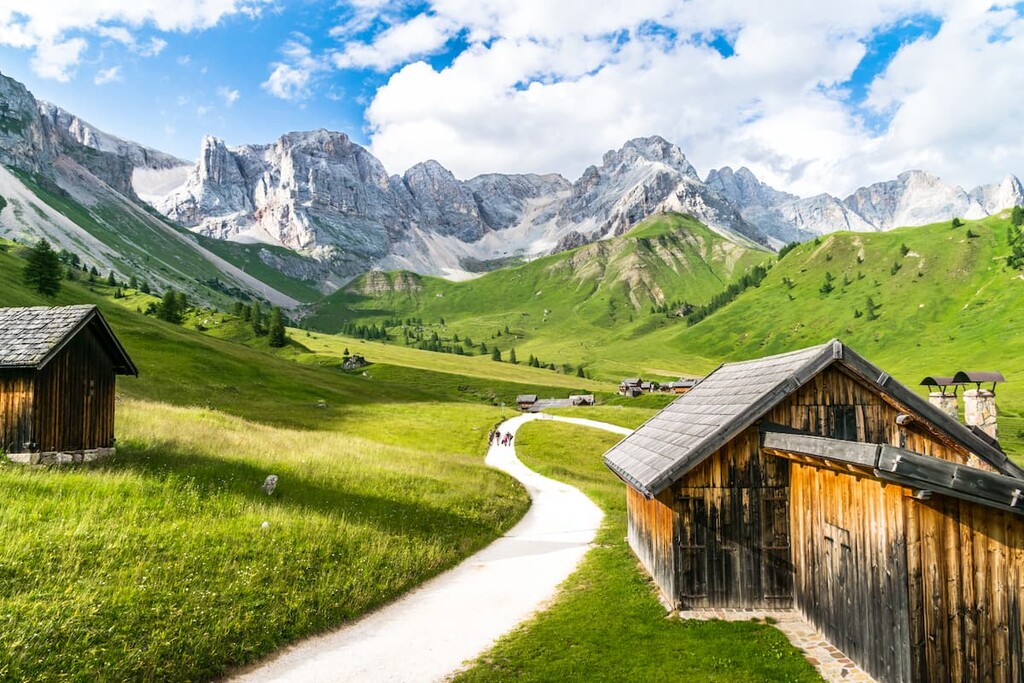
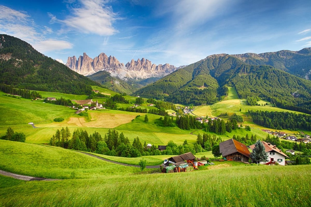
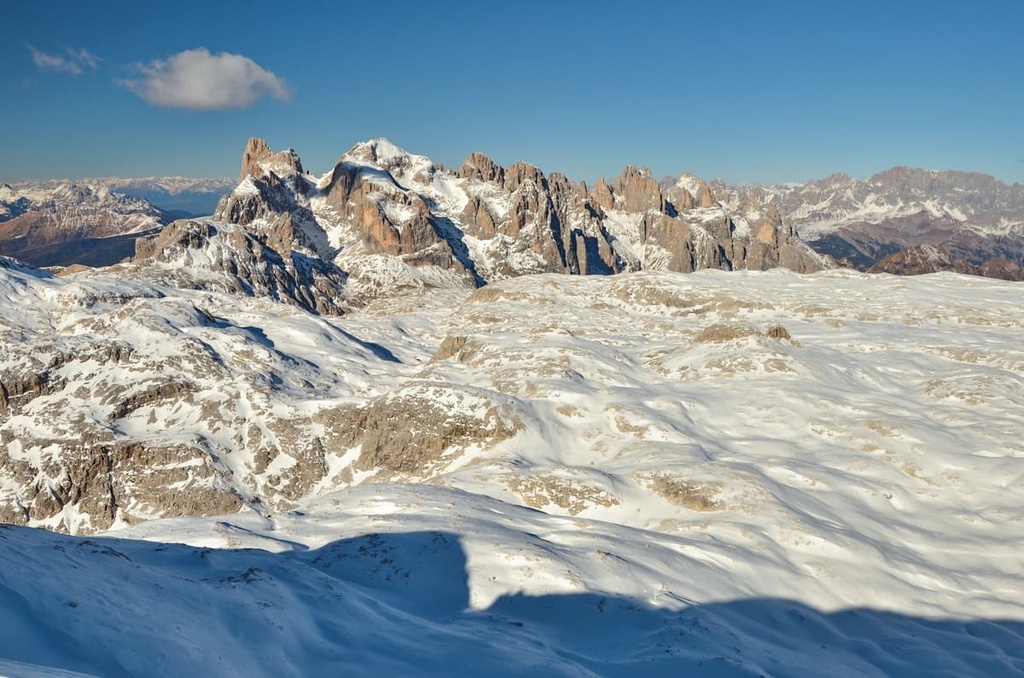
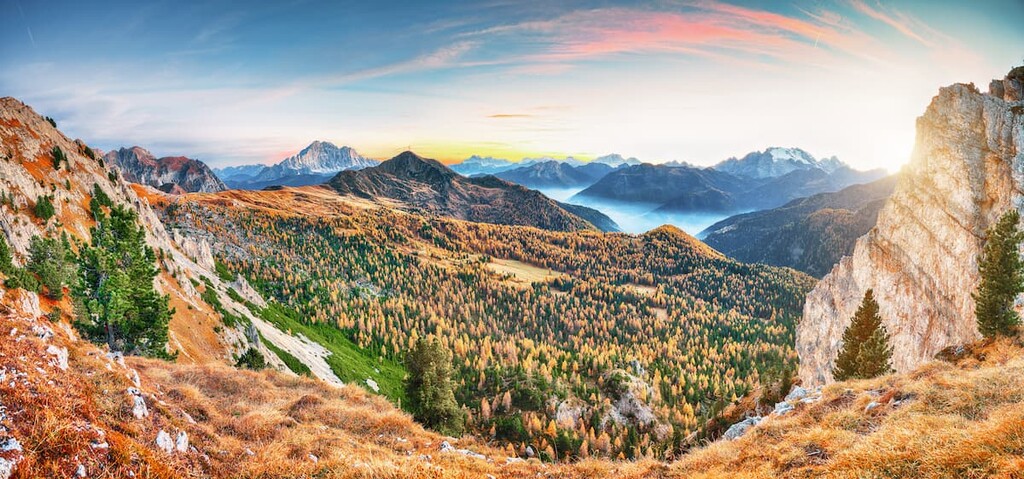
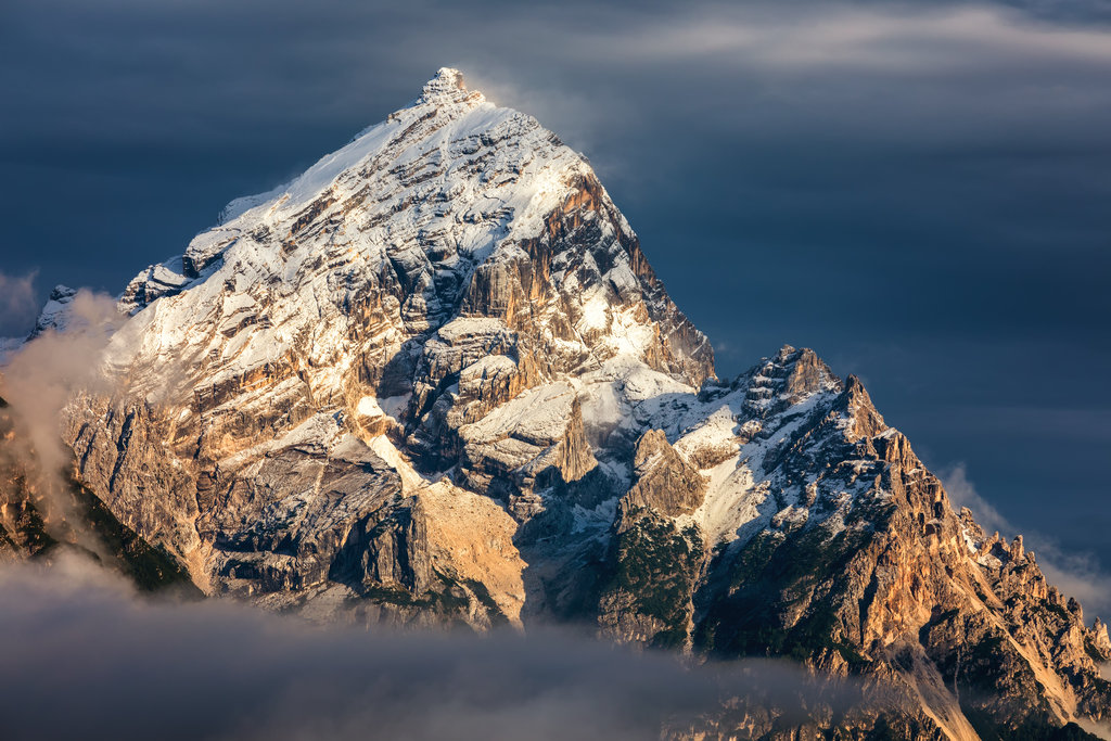
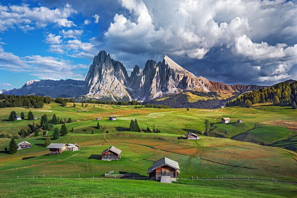
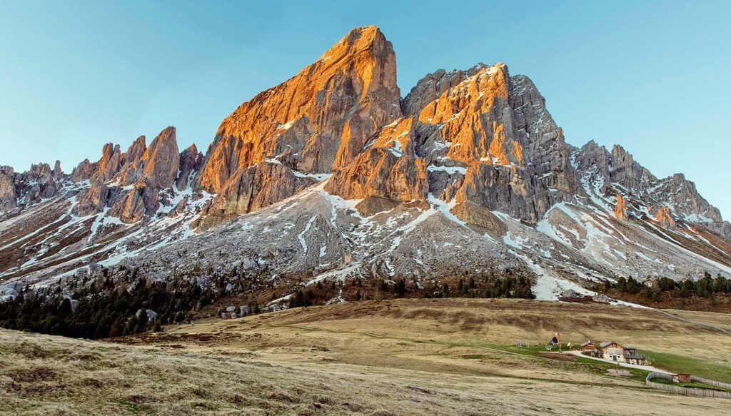
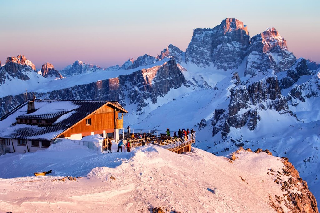
Often called "the most beautiful mountains in the world" because of their unique pinkish and purplish hues at sunset, the Dolomites are a mountain group in northern Italy that is one of the best regions in the world for cycling, hiking, and climbing. There are 2200 named mountains in the Dolomites. The highest and the most prominent mountain is Marmolada (3,343 m / 10,968 ft).
The Dolomites are the home of PeakVisor, so the range is a special place for the app and all who work to develop it. PeakVisor’s founder has also provided his insights for this guide, which we hope will help you make the most of your next visit to this spectacular mountain range. You can find his comments in quotes throughout the guide.
The name ‘Dolomites’ comes from the range’s primary rock type: dolomite. Also called dolostone or dolomite rock, dolomite is effectively a special type of limestone.
The name ‘dolomite’, in turn, comes from the surname of the French geologist and naturalist Déodat Gratet de Dolomieu. He was the first person to describe this mineral in an article for the Journal de Physique magazine in 1791, after having visited before the Dolomites on one of his trips to the Alps.
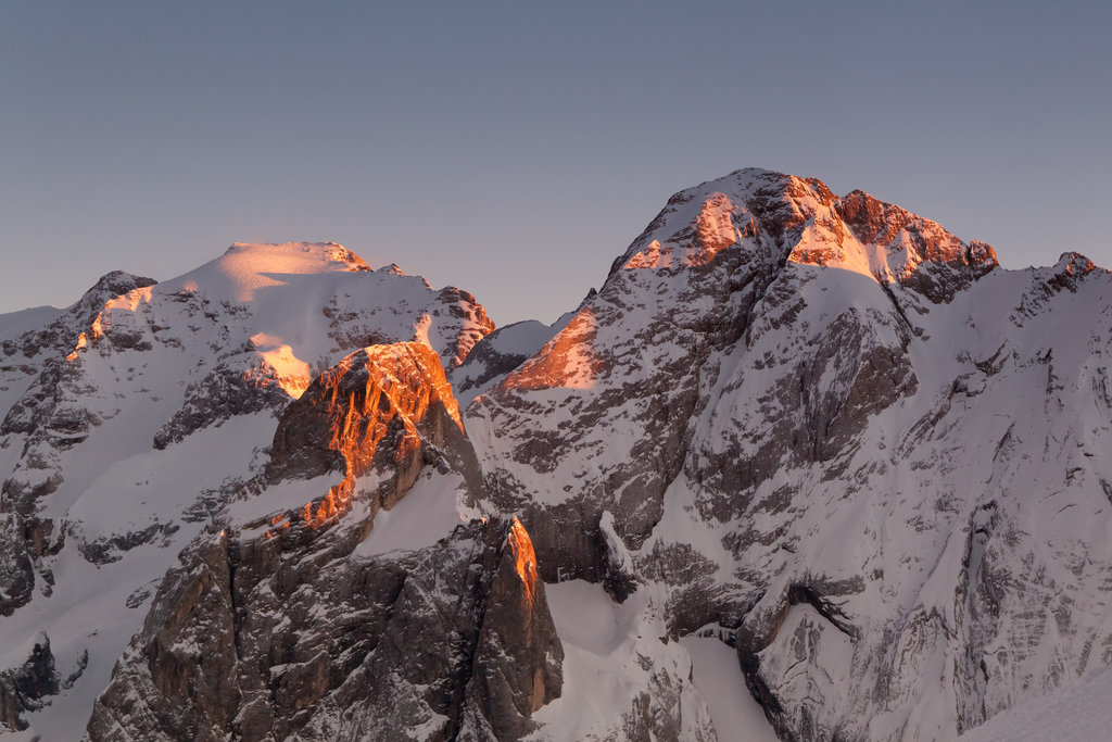
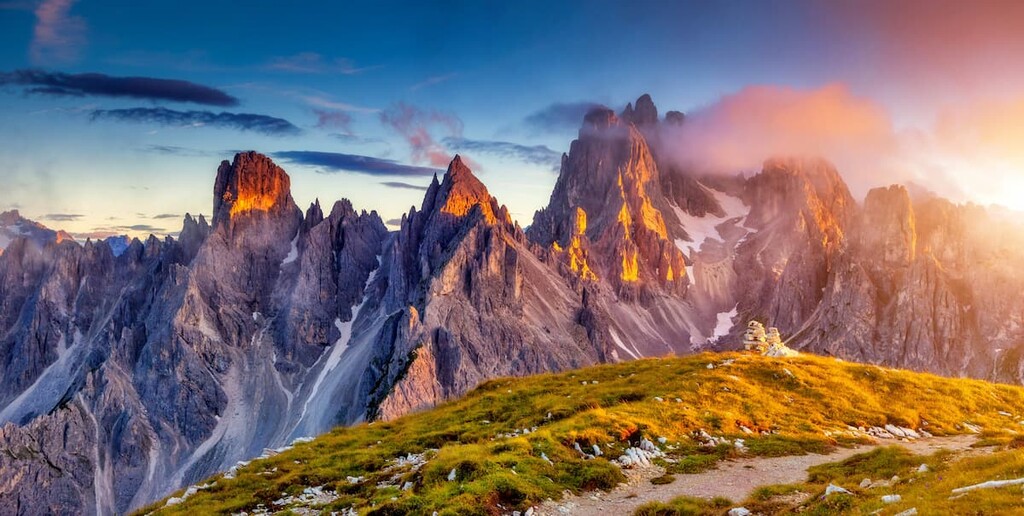
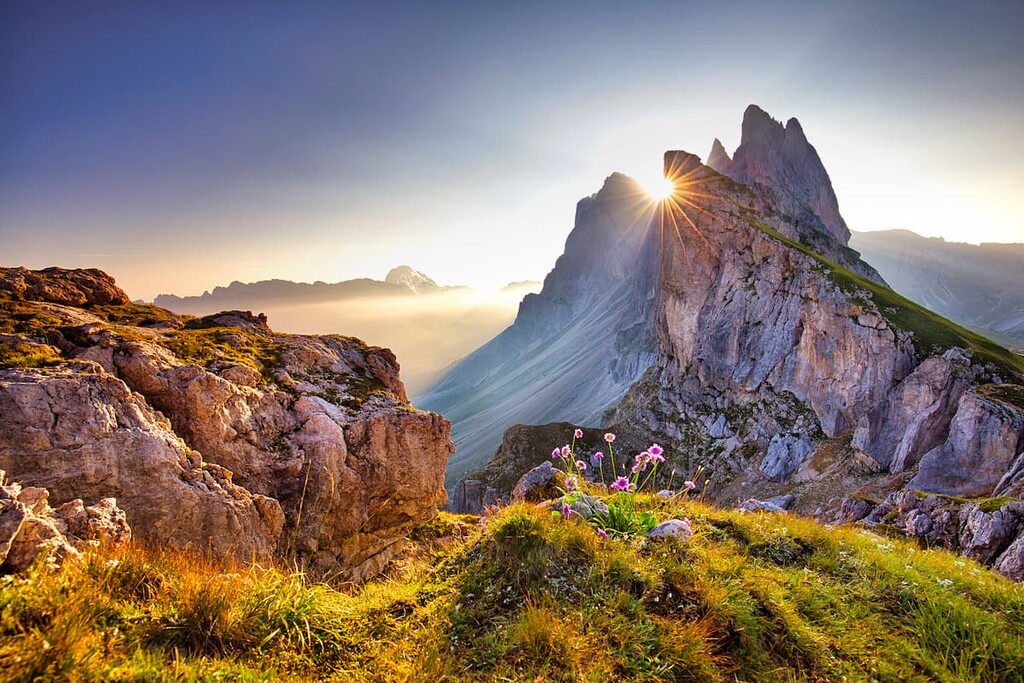
The Dolomites also have many unofficial names that are as common as the official one that we can’t overlook. For example, the Dolomites are also often called “The Pale Mountains” because of the ability of the dolomite to absorb sunlight. As a result, sunrises and sunsets are particularly magical in the Dolomites.
According to PeakVisor’s founder, “the magic is called “enrosadira”—a term that literally means “turning pink” in Ladin, the language of the native people of these mountains (not to be confused with Latin). It is the term given to the phenomenon by which most of the peaks in the Dolomites at dawn and dusk take on a reddish color that gradually turns into violet until the mountains turn gray (or pale) and disappear in the dark of night. Words fail to describe the colorful jagged rocks of the limestone Dolomites. You need to see it at least once in your lifetime.”
Another thing is that, while there are many places with epic scenery, there’s no other place with such a dense concentration of photogenic peaks that contain man-made-like towers, steep rock walls, and impressively deep canyons. That’s why this eastern part of the Alps is often also called “the most beautiful mountains in the world” and “the most beautiful natural architecture.”
The author of the first phase is the most famous mountaineer in the world, Reinhold Messner, who comes from these mountains, the author of the second phrase is the French-Swiss architect Charles-Édouard Jeanneret, known as Le Corbusier.
Finally, the Dolomites have different names in different languages: Dolomiti in Italian, Dolomiten in German, or, for example, Dolomiitit in Finnish. The Ladins traditionally use the international variant—the Dolomites. You can also find the spelling “Dolomite Alps” because these mountains belong to the Alps and are often called “Prealps”, too.
The Dolomites are located in northern Italy and are contained within three regions and six provinces: Veneto (Belluno, Vicenza and Verona), Friuli—Venezia Giulia (Udine and Pordenone) and Trentino—Alto Adige / South Tyrol (Trento, Bolzano / South Tyrol).
In other words, a trip to the Dolomites is a journey into several countries and regions, each with a distinctive culture. This includes northern Italy (which is different from central and southern Italy), former Austria, and Ladinia—as the Dolomites are also called by the Ladins. In addition, the Dolomites are part of the Alps, so they are very similar in lifestyle to other Alpine regions like the French Alps or the Swiss Alps.
The total area of the Dolomites is relatively small compared to other ranges in the Alps—15,942 sq km (6,155 sq mi).
To drive through the range from the south to the north—for example, from Venice to Bolzano, you need only four hours to cover 233 km (144 mi). The same route from Riva del Garda in the famous Garda Lake to Pordenone from the west to the east takes almost the same three hours and 15 minutes (238 km / 147 mi).
You can get to the Dolomites from anywhere in the world by flying first to one of the nearby airports in Venice, Treviso, Verona, Bergamo and Milan in the south, or Bolzano in the north. There is also the airline Air Dolomiti, which flies, for example, from Verona to Munich, Germany.
Then, in Italy, you will need to transfer to Trenitalia trains and take a bus from one of the several local companies: Dolomiti Bus, Trentino Trasporti, Suedtirol Mobil, Trieste Trasporti, Arriva, and others.
The dolomite rock is the main reason behind the amazing process of changing colors of these mountains.
Here’s how the enrosadira process actually works: “The calcium carbonate and magnesium carbonate of the dolomite allows the soft light yellow hues to transmute into a bedazzling bright red or to turn into various loud shades of pink and violet.”
Dolomite began to form in this region about 230–250 million years ago during the Triassic period. Back then, there was a tropical ocean that covered much of the region. Coral, calcareous algae, and other sea creatures accumulated at the bottom of the sea, forming atolls or coral reefs. These atolls and reefs were similar to those found today in the Caribbean Sea off The Bahamas or the Pacific Ocean off the coast of Australia.
Over time, the collision of the European and African tectonic plates, combined with the draining of this ancient sea, left the reefs exposed on the surface. This activity also caused the land to rise to elevations of more than 3,000 m (9,842 ft) high. These newly formed mountains were affected by wind, erosion, volcanic eruptions, among other natural phenomena, which over many tens of millions of years, gave the Dolomites the topography that we see today.
Interestingly, this geologic history has been confirmed by the numerous finds of fossilized shell remains and other marine life in the high-elevation cliffs of the Dolomites.
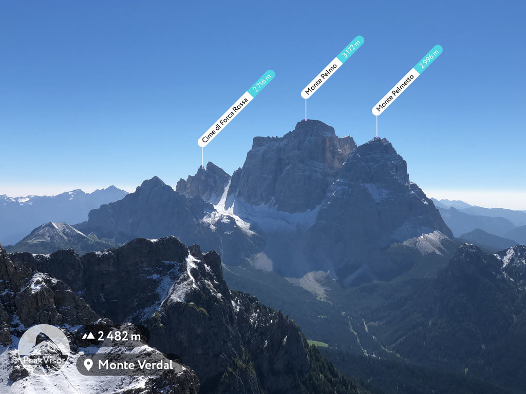
Speaking of fossils, another great geological fact is that the Dolomites were once home to dinosaurs. You can still find their traces right in the rocks, for example, on Mount Pelmo (3,172 m / 10,407 ft), in the Brenta Dolomites, or at the educational trail from the Museum of the Histories of the Rovereto (Museo Civico di Rovereto) near the Trento.
I was very lucky: the Dolomites were the first mountain range that I had ever been in—and I immediately fell in love with their incredible landscape, which at the same time has similarities with other groups in the Alps and other mountains. If you’re on your way to the Dolomites, here’s a quick glimpse of what the landscape is like in the range:
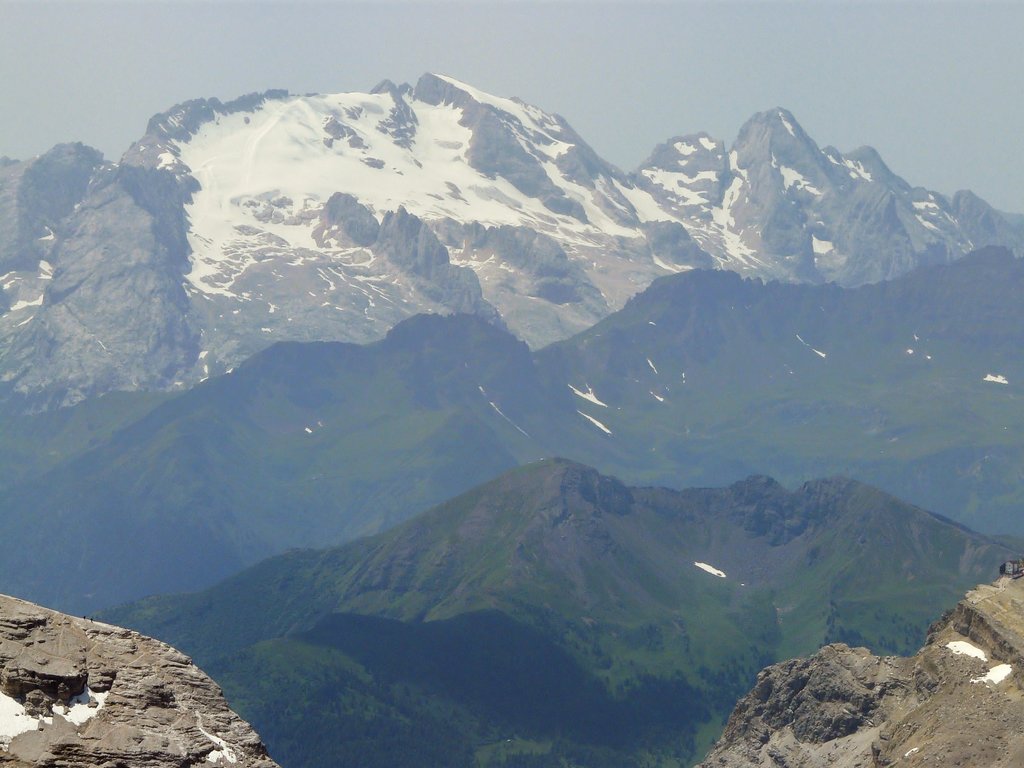
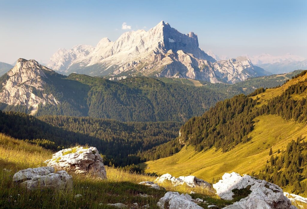
The peaks of the Dolomites rise to almost 3,500 m (11,482 ft) above sea level. Yes, these are “small mountains” compared to the rest of the Alps, which is why the Dolomites are also called Prealpes—but the peaks are impressive nonetheless.
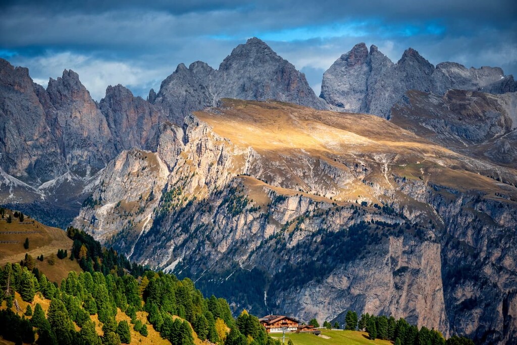
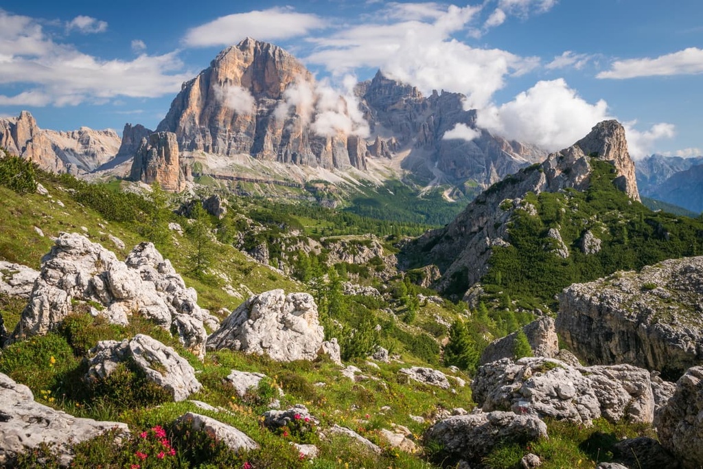
Nowhere else in the world will you find such a concentration of peaks of different unusual shapes and features, including smooth vertical walls, towers, and pyramids, all of which seem to have been built by some giants of the past, and not nature.
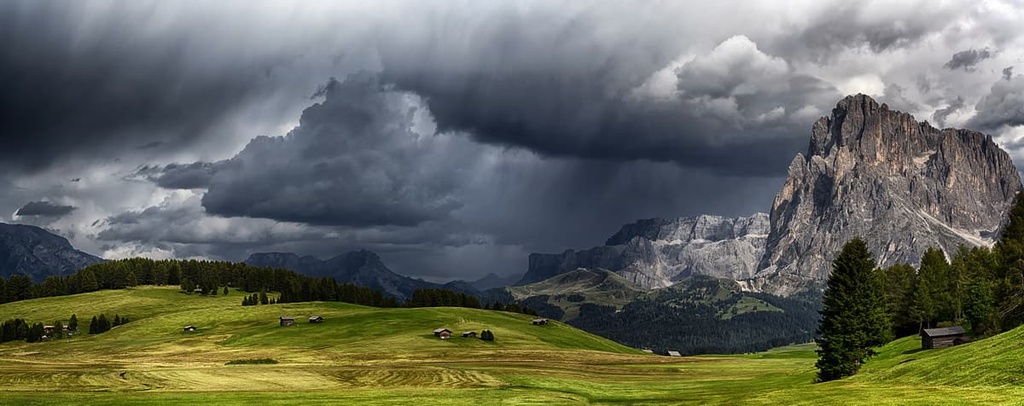
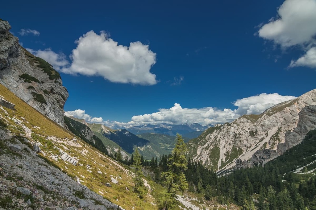
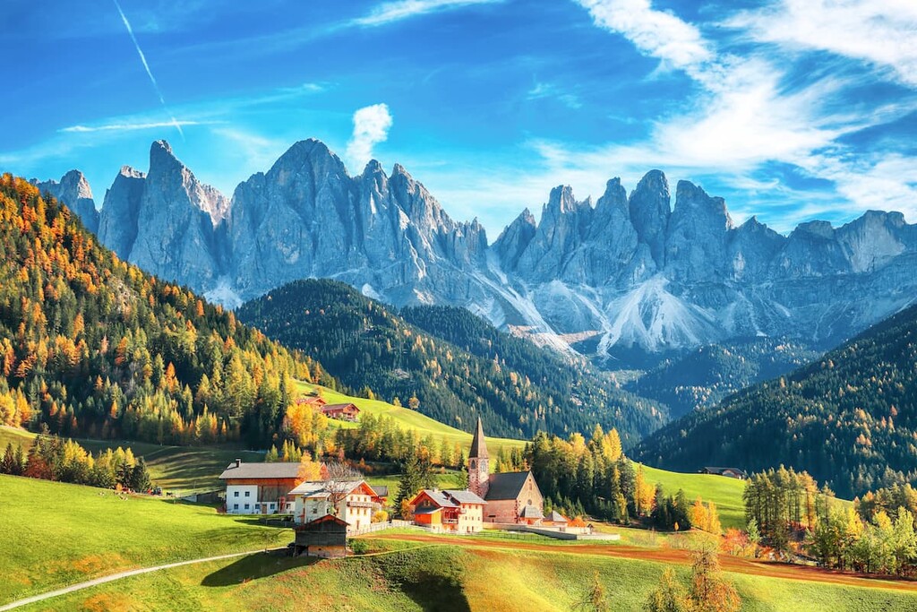
From the mountain peaks and high Alpine plateaus like, for example, Seiser Alm (Alpe di Siusi), which is actually the largest high-altitude Alpine meadow in Europe, we descend into Alpine valleys with postcard vistas through forests growing to about 2,000 m (6,561 ft).
The most famous valleys of the Dolomites belong to and are associated with the Ladins. There are exactly five traditionally Ladin valleys:
However, there are many more non-Ladin valleys, including the Valbelluna, Val di Landro, and Val di Zoldo, among others.
The valleys of the Dolomites were generally formed by wide, raging rivers, such as the Brenta, the Adige, and the Piave, which are the largest in the region.
As in other mountain groups in the Alps, it is possible to get from one valley to another through mountain passes. The top ten highest passes in the Dolomites are as follows:
According to PeakVisor’s founder, "in particular, Passo Giau is one of the most scenic drives in the area, with multiple trails leading off in various directions from the road. Passo Role is one of the best sunset locations, where the best spot for a sunset photo is at the summit of Tognazza just a short uphill walk from the pass’s parking area."
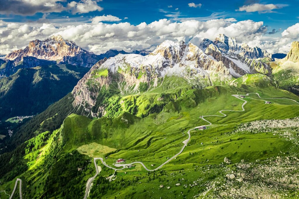
In total, there are 30–50 major passes in the Dolomites. Each pass works like a hub for different sports and outdoor activities: skiing in the winter, hiking, cycling and climbing in the summer, traveling all-year round. Usually on the passes there are mountain huts (rifugio in Italian), where you can have a coffee, dinner or to spend a night there.
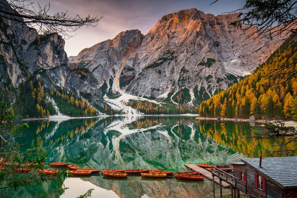
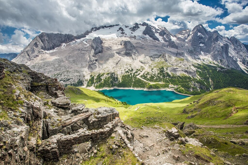
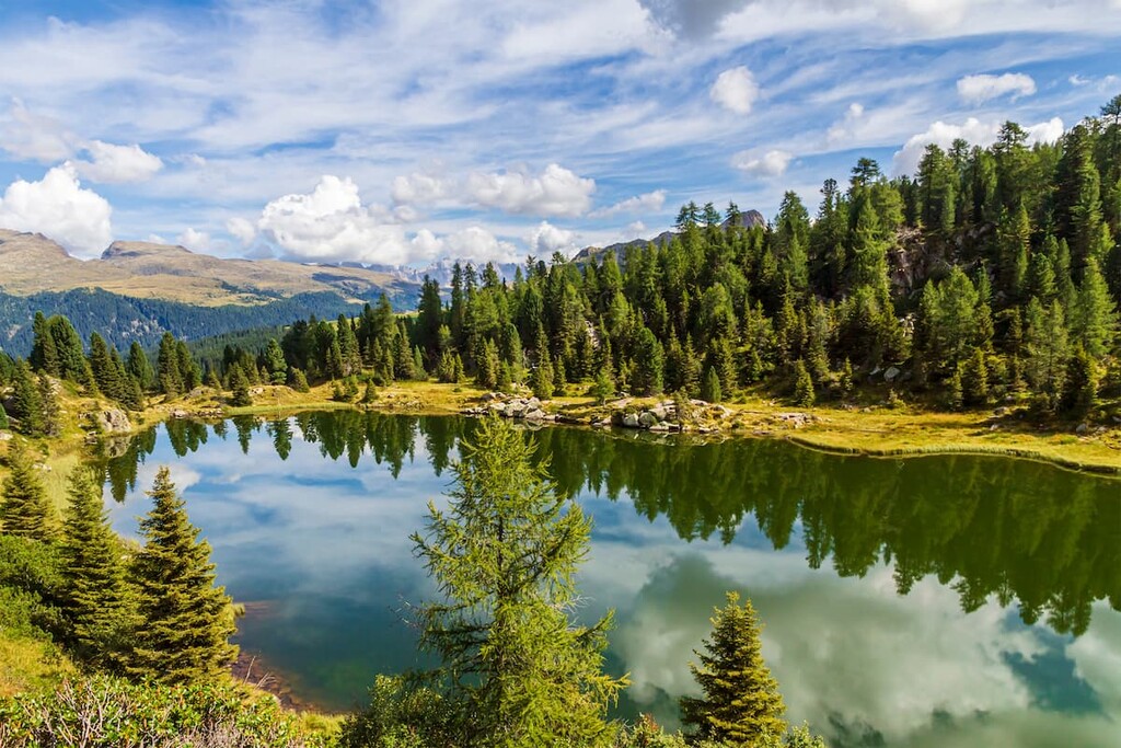
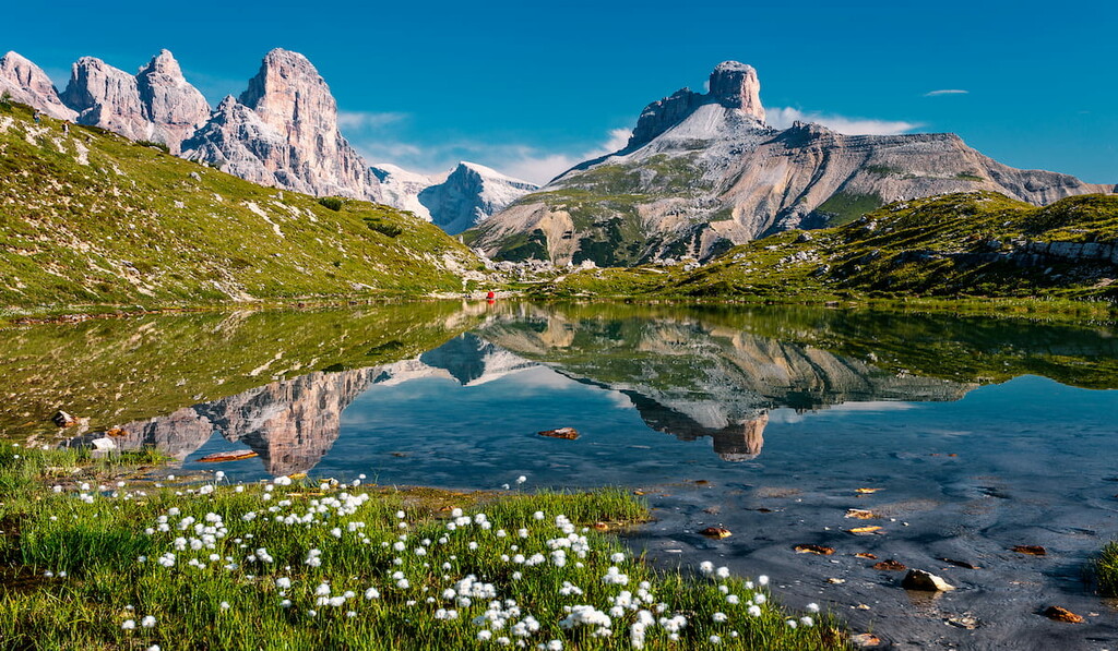
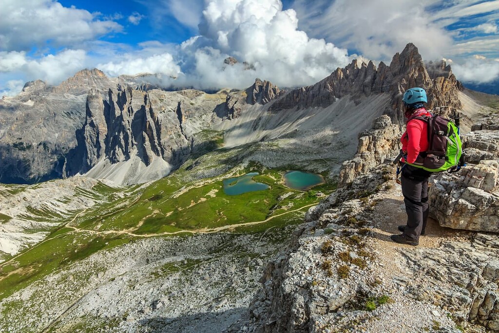
The Dolomites are also famous all over the world for their gorgeous alpine lakes with their milky azure waters. You may have already heard about the most famous lakes in the range, which include:
Again, according to PeakVisor’s founder, “on the Lago di Braies, you could spend a day by the lake or hike to the very top of the Seekofel (2,809 m / 9,219 ft) mountain just above the lake, then return and have a refreshing swim. The Sas dla Crusc (9,928 ft) is another summit in the area with panoramic views reachable after a long hike through the park. It is a great way to appreciate its beauty.”
He continues: “On the Lago Sorapiss at the foot of Punta Sorapiss mountain, it takes slightly less than two hours to reach the summit from the nearby parking area. In the high summer season, there could be traffic jams on the narrow trail. But if you get there there will be no questions why everyone is eager to see it.”
Other famous lakes in the range include Lago di Alleghe, Lago di Tovel, Lago di Landro, Lago di Centro Cadore, and Lago di Senaiga in my home town of Lamon. Many of them are not of natural origin, but are actually man-made. They were formed as a result of the construction of plateaus for the creation of hydroelectric stations.
In some places, from the valleys one can go descend even further down from the summits of the Dolomites into canyons, gorges, grottoes, and caves. In fact, there are many of these features here, too, though they are less well known than the peaks, passes, and valleys.
For example, in Rio Sass Canyon in the Val di Non near the city of Trento, you can go down 145 m (475 ft) through 348 steps of the various staircases. Another famous canyon, Limarò, which is carved by the waters of the Sarca River is located even closer to Trento.
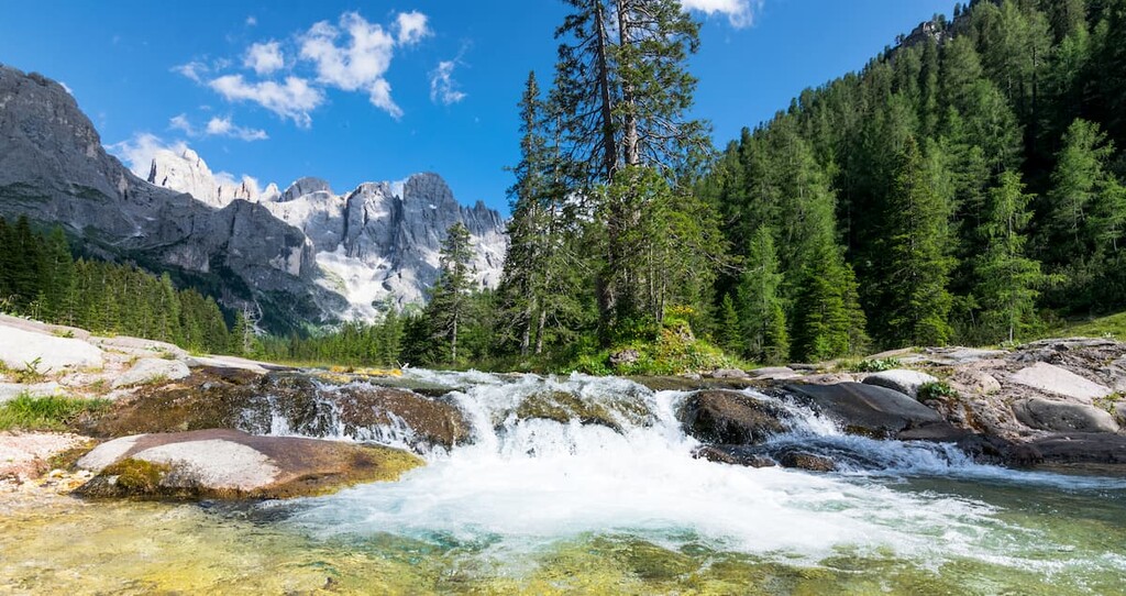
The third, which I would note here, is located near my hometown of Lamon in the valley of the Senaiga torrent, including a 70-meter (229 ft) waterfall called Salton. By the way, there are many fantastic waterfalls in the Dolomites, too.
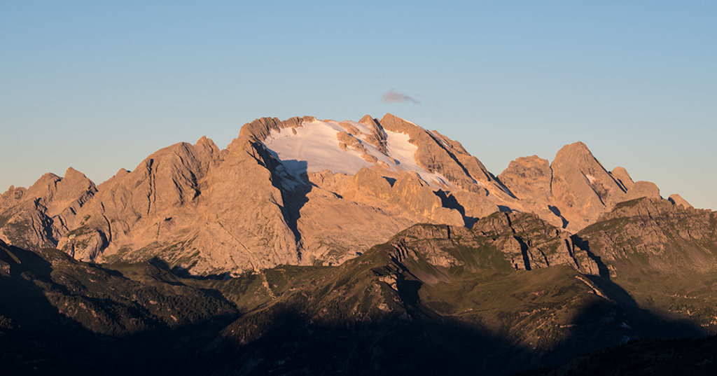
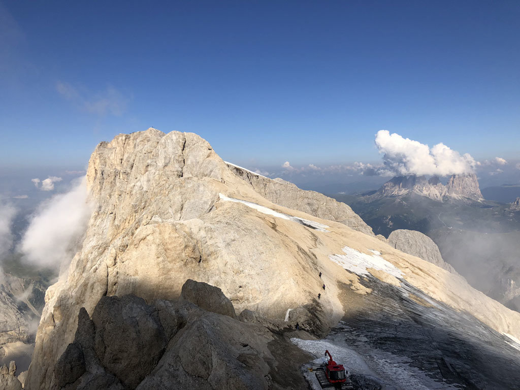
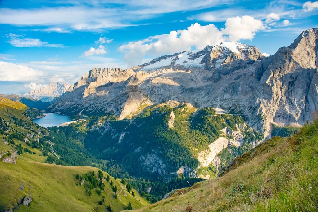
Finally, returning to the highest peaks of these mountains, we find ourselves on glaciers. Predictably, the largest glacier in the Dolomites (1.6 sq km / 0.6 sq mi) and the only one that does not melt even in summer, is located on the highest mountain Marmolada, and is called Marmolada Glacier.
In total there are 31 glaciers in the region with a total area of 2.7 sq. km (10.4 sq mi), which is not very many compared to, for example, the glaciers in the Adamello-Presanella Alps to the west of the Dolomites.
The flora and fauna of the Dolomites are generally typical of the Alps, in which, however, it is possible to identify some unique plants and animal species.
Most of the Dolomites are dominated by alpine meadows. In early summer, the meadows are full of different flowers, including saxifrage, crocus, narcissus, clover, Erika, forget-me-not, aster alpine, and 50 types of orchids. You can also find here edelweiss—the symbol of the Dolomites and the Alps.
At elevations of up to 2,000 m (6,561 ft), there are spruce, pine, and fir forests. There are also mixed forests with many beech, birch, maple, and other trees that are also covered by different types of moss and ivy.
In the forests, you can pick some edible mushrooms like golden chanterelle and penny buns, and some berries like wild strawberries. However, there are fewer edible mushrooms and berries here than in more northerly regions of the world, such as my native Karelia in Russia and in nearby Finland.
Anyway, never pick any mushrooms and berries in the Dolomites if you don't know them. There are many more poisonous types of plants here than edible ones. Walking in the forest here, you can see many warning signs telling about the prohibition of picking berries and mushrooms due to this danger.
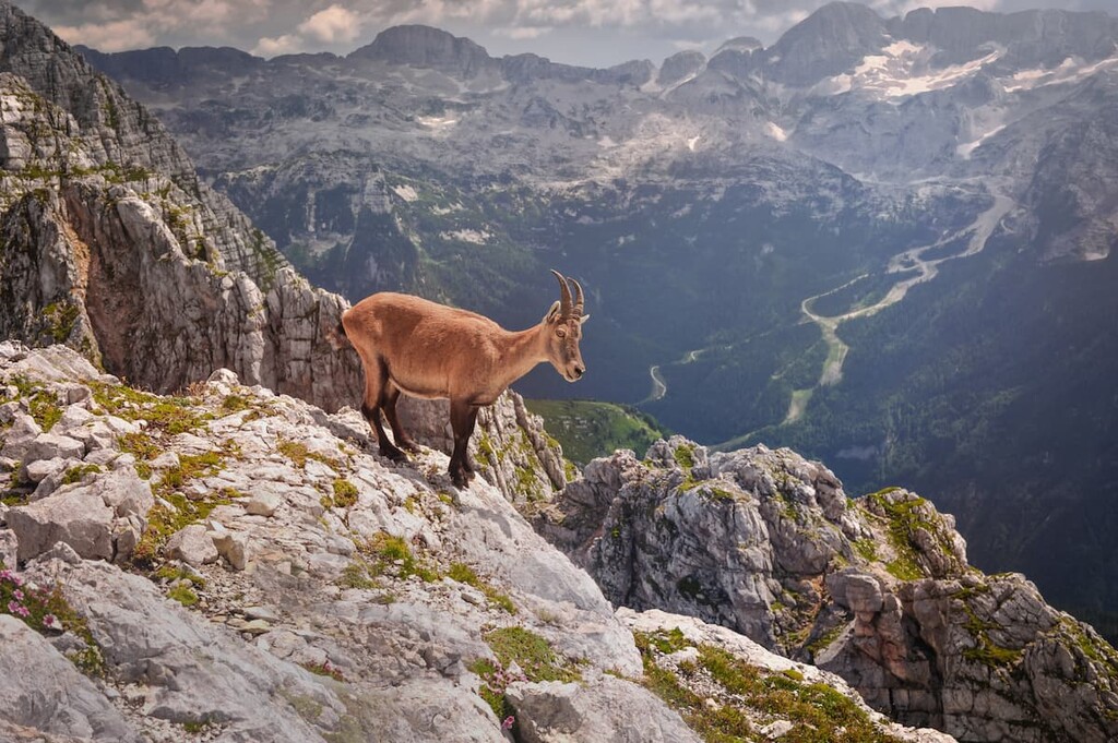
The rocks, forests, and meadows of the Dolomites are home to many animals that are typical for this kind of landscape, like hares and foxes. However, the symbols of these mountains are considered to be the brown bear, chamois, and other mountain goat species, as well as deer, and groundhog.
Except for bears, it is quite easy to meet all of these species just by hiking one of the high paths in the range. But if you want to see, for example, the deer on purpose, you can visit Paneveggio—Pale di San Martino Nature Park where they are known to graze in a field.
In the sky, you can see and listen to many birds like eagles, hawks, owls, partridges, and others. In rivers, there are trout and other fish species. In lakes and streams, there are tritons, salamanders, and other reptiles.
All of these animals are not inherently dangerous, except maybe viper snakes, which in spring and summer fall out to bask in the sun. As you can imagine, it’s best to avoid these snakes whenever possible.
The official tourist organizations say: “In the Dolomites, you can travel and enjoy the outdoors all year round.”
This is (for the most part) true, but that doesn’t mean that there’s always good weather and that you can do any activity you want regardless of the season. It’s better to be prepared and to learn about the climate, seasons, and weather in the Dolomites before your trip.
Italy is a warm southern European country with a subtropical Mediterranean climate. But the higher you climb to the north from the south, the colder it gets. In the Dolomites, the climate is closer to Continental than it is to Mediterranean.
For example, the average minimum temperature in Palermo, the capital of the island of Sicily, during the year is 16°C (60.8°F), in the so-called capital of the Dolomites, Cortina d’Ampezzo, it is 1°C (33.8 °F).
But in the Dolomites, it is still warmer than in my native Republic of Karelia in Russia, or in the Scandinavian Mountains. Spring arrives 1–2 months earlier here than in northern Europe and winter tends to arrive later. The weather here is also more stable both in the summer and in the winter.
What’s interesting is that in Italy, seasons are defined by the astronomical calendar rather than by the civil calendar, as is the case in some other countries.
The spring in the Dolomites starts from the end of March and continues to the middle of June. But in some years, it could be quite hot even in the beginning of spring for a couple of days or a week, sometimes up to 20–25°C (68–77°F).
Spring is my favorite time of the year in the Dolomites: The new leaves on the trees are very bright green, and starting in the second part of May, there are many alpine flowers everywhere.
The summer in the Dolomites officially lasts exactly three months: It begins on June 21, the summer solstice, and lasts until September 21st, the autumn equinox. By the end of June, the last snow melts in the mountains above 2,000 m (6,561 ft).
During these three months, all mountain huts and cable cars in the Dolomites are operating, the maximum number of buses runs between cities and villages, so you can go everywhere by public transport, as well as on foot.
However, you might still be able to enjoy summer-like conditions from early April to late November. Between these months, there’s generally snow above 2,000 m (6,561 ft), so take snowshoes and crampons into the mountains. Below 2,000 m (6,561 ft), the ground is normally snow-free.
In the middle of July, at the foot of mountains, it can be 25–30°C (77–86°F), but at the summits, it can be 15–20°C (59–68°F) during the day and 10–15°C (50–59°F) at night. The closer you get to autumn or spring, the colder it gets.
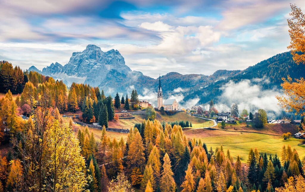
The autumn in the Dolomites lasts from the end of September to November-December. It is very beautiful as all the trees turn gorgeous shades of red, orange, and yellow.
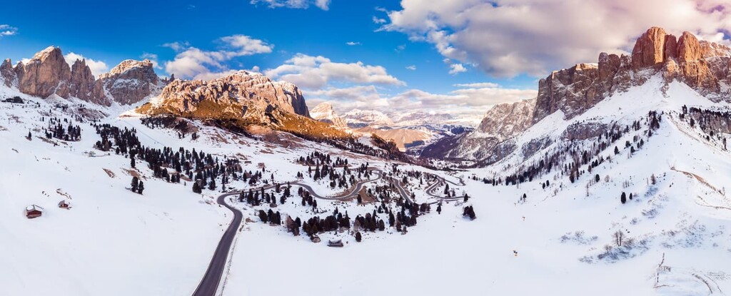
The winter in the Dolomites also usually starts a little bit earlier but usually not later than in the astronomical calendar. In general, the first snow falls between October and November, but, for example, in 2019 the first huge snow falls came on September 10. In winter, it is cold in the mountains above 1,000 m (3,280 ft) and the temperature often drops below zero, sometimes to -20°С (-4°F).
So the winter is the main climatic difference between the Dolomites and the rest of Italy. There is a lot of snow in the mountains in the Dolomites, and the snow can sometimes be up to 10 m (32 ft) high. This is why winter sports are so popular in the Dolomites, however, this means that some roads and mountain passes are closed to traffic in winter.
There are several dozen glaciers in the Dolomites. The largest one is located on the highest mountain Marmolada, 3,342 m (10,964 ft). It does not melt, even in the summer (this is what makes it a glacier).
In my home in the Pale di San Martino mountains, there is the Fradusta glacier at 2,393 m (7,851 ft). But it is relatively small and has been shrinking in size for several decades due to climate change.
The main feature of the weather in the Dolomites is its variability, everything can change within one day several times, especially in the spring. It rains a lot in the spring. My village Lamon, in particular, is considered the rainiest place in the Dolomites and Fiemme Mountains. There’s even a poem on the subject:
Rain in Belluno—no one gets wet,
Rain on Mount Avena—will soak your back,
Rain in the village of Seren—will soak the hay,
Rain in Lamon—will soak everywhere.
But after the rains, it’s beautiful as you often get to see incredible clouds flying through the sky. In the spring, the landscape changes every couple of minutes thanks to all this rain.
In contrast, October and November have the least rain and the least cloudy skies. This makes the fall the best time not only for hiking and cycling but also for photography.
Another common and important weather feature in the Dolomites is the strong sun. It’s very hot here in the summer afternoon. In villages, people go out until 10 to 11 o’clock and then disappear before sunset—only then is it a bit cooler and you can go out again.
In winter, the sun can burn your skin immediately, so you have to use sunscreen. Don’t forget to apply sunscreen to your lips, too, as these tend to burn easily in the Dolomites.
The wind is also strong in the mountains in general. In particular, hurricane-force winds are very common in the Eastern Alps. Gusts of dry and cold local wind Bora can reach up to 200 km/h (124 mph).
The last very strong storm Vaia (Adrian) happened in the Dolomites relatively recently in October 2018. It destroyed not only individual trees but entire forests and a lot of infrastructure with hundreds of millions of euros worth of damage.
Thankfully, the weather forecasts in the mountains are more accurate in general than for the nearby plains: If on Monday morning it is forecasted that there will be a rain or storm on Wednesday afternoon, then, most likely, this will be the case.
Of course, no forecast is always 100% accurate, so always pay attention to the weather when you hike in the Dolomites. Pack everything you need to handle the rain and wind, and be more cautious during the shoulder seasons.
The bottom line: If you want to go hut-to-hut hiking, cycling and mountain biking, trail running, climbing, or climbing on via ferratas, I would go between late June and late August to early September, excluding July when it is sometimes too hot. For skiing and other winter sports, anytime between December and March is excellent.
The Dolomites are a unique region, not only in terms of their natural beauty but also in terms of human history and the environment that humans have created for themselves by settling in these mountains. Here are the brief stages of this long history of human habitation in the Dolomites:
Since ancient times, the Dolomites have been inhabited by different tribes that were mainly engaged in hunting and gathering. These tribes generally led a nomadic, rather than sedentary, life, moving from one valley to another and back again.
Their presence is evidenced by the numerous archaeological sites in the range, such as those at the foot of Mount Colbricon (2,509 m / 8,232 ft) in the Paneveggio—Pale di San Martino Nature Park.
The more modern group of these tribes is known today as the Raeti or Rhaetian people. Some ancient authors identify them with the Etruscans, the predecessors of the Romans. They are also the ancestors of the Ladins, the Indigenous community of the region.
At the time of the Western Roman Empire (27 BC–476 CE), the Rhaetians had already been conquered by the Romans in 15–13 BCE. That’s why historically, eastern Dolomites belonged to the Venetian Republic and Italy, where the Veneto region is today, and the western Dolomites to the Germans.
In 1140, while the eastern part of the Roman Empire, with its capital in Constantinople, still existed, the Kingdom of Tyrol was created in the Alps and in the Dolomites. This kingdom existed during the Middle Ages until 1804.
In 1789, as we already know, the Dolomites were opened to the world when the French scientist and explorer Déodat Gratet de Dolomieu discovered a particular mineral that was previously unknown, examined it in a laboratory, and wrote a now-famous article about it.
Then, at the end of the next century, came the Golden Age of Mountaineering. This is the decade between 1854 and 1864 when many famous peaks in the Dolomites and the rest of the Alps saw their first ascents.
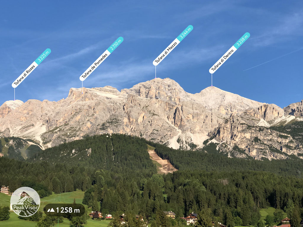
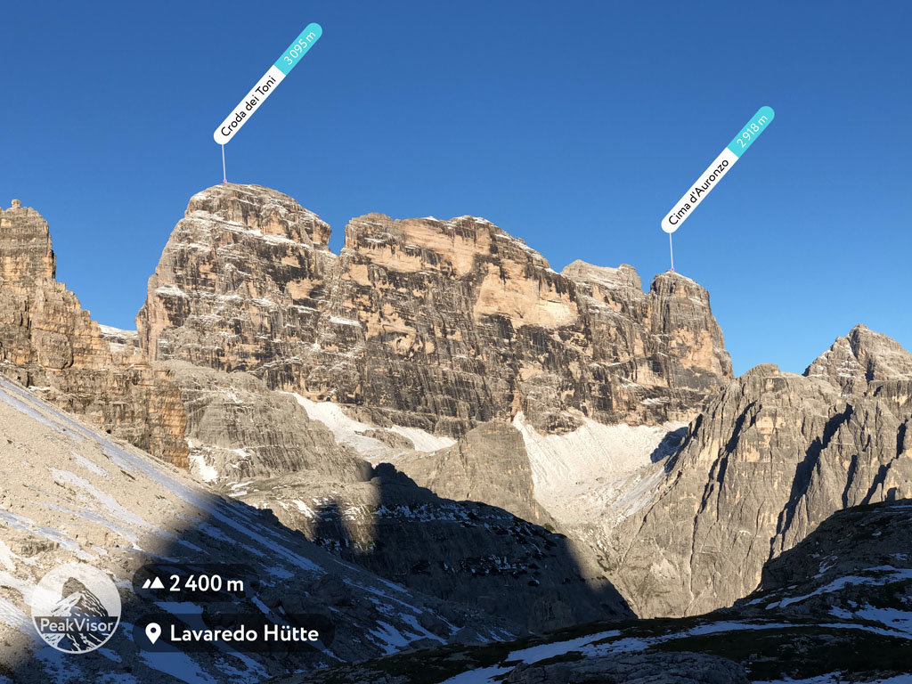
One of the most famous examples is the Austrian climber Paul Grohmann, mastermind of many of the most important first ascents of the Dolomites, including those of Tre Cime di Lavaredo (2,999 m / 9,839 ft), Tofana di Mezzo (3,244 m / 10,643 ft), and Monte Cristallo (3,221 m / 10,568 ft), among others.
By this time, the Dolomites had started to become not only popular climbing but a tourist destination, because many of these climbers also wrote the first travel guides to the region.
In particular, in 1864, the book The Dolomite Mountains by the two Englishmen Josiah Gilbert and J. S. Churchill was published. The book became very popular and cemented the "Dolomites" name for the mountains, which now described not only the mineral itself but the entire mountain region.
World War I (1914–1918) was a difficult phase in the history of the Dolomites because the front line between the Italian and Austro-Hungarian armies passed through here.
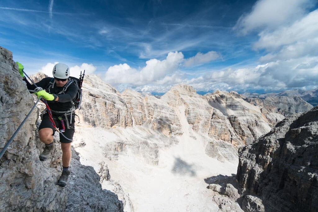
Various open-air military museums are still located here today, for example on, Monte Piana (2,324 m / 7,625 ft), on Mount Lagazuoi (2,804 m / 9,199 ft), and on Marmolada. Also, many via ferratas—metallic trails and stairs right through the rock walls—were created during the war for the defense of certain peaks. After the war, the provinces of Trentino and South Tyrol were ceded to Italy.
In the twentieth century, after the end of World War II, the Dolomites continued to gain in tourist popularity, despite the complex political division of the region. It became even more popular in the twenty-first century after the Dolomites were included in 2009 in the list of World Cultural Heritage of Unesco.
Today the Dolomites is one of the main mountain tourist regions in Italy, Europe, and even the world. This prestige is thanks to the endless possibilities for outdoor activities found in the range and, of course, its unique nature and human history.
The most important event of the near future in the Dolomites is the Winter Olympics. The XXV Olympic Winter Games are to be held in Cortina d'Ampezzo (and Milan) in 2026. They will be the fourth Olympic Games hosted in the country.
Interestingly, Cortina d’Ampezzo also hosted the 1956 Winter Olympics, though the 2026 games will be the first to be held in Milan.
In another interesting twist of fate, the 1944 Winter Olympics were also meant to be held in Cortina d’Ampezzo. However, they were cancelled due to the onset of the Second World War. The Games resumed in 1948 in St. Moritz, Switzerland and Cortina d’Ampezzo was awarded the 1956 Winter Olympics, instead.
The Ladins are the primary ethnic group that historically lived in several valleys located in the heart of the Dolomites for the last few centuries, like the Karelians in the Republic of Karelia in Russia or the Basques in the Basque Country in Spain.
But the Ladins live not only here, but also in other regions of northern Italy and Switzerland. There are 30,000-35,000 ethnic Ladins in total around the world, though they comprise about 4.53% of the population of the South Tyrol region.
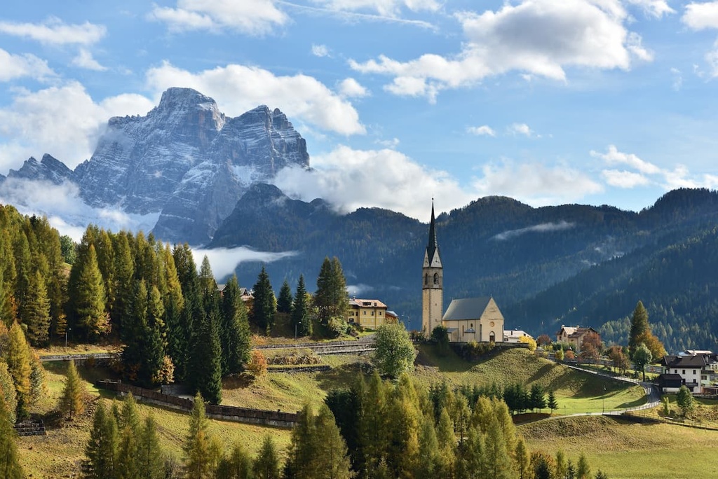
The center of Ladins is the five world-famous valleys of the Dolomites: Val Gardena, Val Badia (also known as Alta Badia), Val di Fassa, Valle di Livinallongo and Val di Ampezzo.
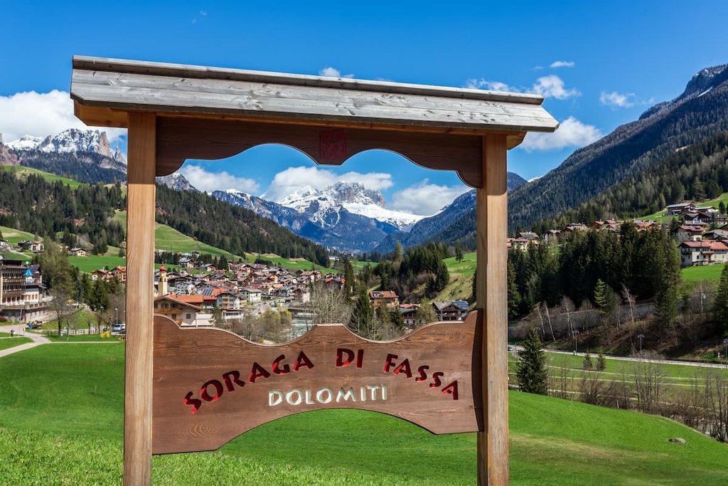
The Ladins live in the following specific communes: Cortina d’Ampezzo, Ortisei, Badia, Marebbe, Moena, Selva di Val Gardena, Pozza di Fassa, Canazei, Santa Cristina Valgardena, San Martino in Badia, Livinallongo del Col di Lana, Corvara, La Valle, Laghetti, Vigo di Fassa, Campitello di Fassa, Soraga, Mazzin, Colle Santa Lucia.
This region is also called Ladinia or the Kingdom of Fanes after a national folk epic of the Ladins. The territory occupies 1,200 sq km (463 sq mi). The main mountains and mountain ranges in Ladinia are Sella, Marmolada, Antelao, Cristallo, and many others.
Ladins speak their own language called the same—Ladin language. The name of the language means “vulgar Latin”—a dialect left by Romans after the Romanization of the Alps. Sometimes it is also called the Tyrolean Romanian language, Dolomite language, or Trentino language.
Ladin is spoken in these five valleys and villages, which I just mentioned, but also in other places in the region of Trentino—Alto Adige/Südtirol, where it is officially recognized, as well as in the north of the province of Belluno, region of Veneto, where it has the status of a protected language. Both oral and written languages are used in official institutions, on road signs, and taught in schools.
The Ladin language also has several common dialects, depending on the valleys. People in Val Gardena, Val di Fassa, Val di Zoldo speak and write in slightly different ways. The written Ladin language is based on the Latin alphabet with the addition of several letters. In general, the letters in Italian and Ladin (as well as French and Spanish) are very similar.
So traveling in the Dolomites don’t be surprised if you hear and see some new language, which is different from Italian or German.
Like almost every ethnic group in the world, the Ladins have their own legends, tales, myths, and beliefs.
Legends of Ladins tells about kings and princesses, mountain shepherds and knights, dragons and other incredible creatures, and all kinds of natural phenomena you can observe hiking these mountains.
“The Kingdom of Fanes” is the main, but not the only work of literature by Ladins. Actually, even this one wasn’t written by any Ladin. Like everywhere in the world, people told tales from month to month before. So this and about 10–20 other legends were collected by Karl Felix Wolff (1879–1966), a German journalist, writer, and number one collector of myths and legends of Ladins.
His main book with Ladins legends is called “The Pale Mountains” or “Sagas of the Dolomites”. It is available in English under a slightly different name—“The Dolomites and Their Legends” (Raetia), and of course, in Italian, and German. I also translated several legends from this book into my native Russian.
The second best source of information about Ladins’ legends I've ever found is drawings of legends by an Italian artist Luisa Rota Sperti. She’s from Somana, a village in the commune of Mandello del Lario in the province of Lombardia. Since 1972, she has painted the Dolomites and other mountains.
You can find these drawings on the author’s website Luisarotasperti.com or in the book “Dentro la Montagna. Le Dolomiti tra leggenda e geologia” (“Inside the Mountains. The Dolomites Between Legends and Geology” by an Italian author Paola Favero.
This book is only in Italian, but it is worth having because it will help you to understand the Dolomites much better. It also contains texts of some legends, information about the geology of the Dolomites, and ready-to-go hiking routes to the places from the legends.
This is the main feast of the Ladins. It is dedicated to the return of the domestic animals — cows, goats, sheep, donkeys, and some others — from high mountain pastures back to mountain valleys for the winter. It is celebrated every year at the end of October. The animals leave for pastures in early spring as soon as the snow melts and the grass appears.
Alpine farming is one of the most important components of the economics of the Dolomites. Cows, sheep, and goats give the world-famous Alpine milk, from which cheese and some other products are also produced. Thanks to animals, people live in the Dolomites—not only because they are visited by millions of tourists from all over the world.
So for the people of these mountains, regardless of their ethnicity, this is one of the main holidays of the year, which will allow them to preserve and celebrate the cultural traditions of the region. During the feast, animals are dressed up with colorful ribbons and hats, the inhabitants themselves are dressed up in traditional Alpine and Ladin cloths.
The feast “La Desmontega” represents the return of animals in a literal sense: they pass through towns and villages in one big parade with huge herds from small to large: first goats and sheep, then cows. After a parade of animals, the village is celebrating with music and dancing.
I participated in the feast two times in my home village of Lamon in 2013 and 2018. The feast is also celebrated in Fiera di Premiero, Cavalese, Canazei, Predazzo, Selva, and Soraga in Val di Fassa from where it is believed that the feast took place. In Soraga you can participate in the largest celebration.
Here’s a quick look at the major subranges and summits in the Dolomites as well as the many ways in which the range can be classified within the greater Alps.
According to the Austrian-German Alpine Club classification of the Eastern Alps (EVE), the Dolomites belong to the Southern Limestone Alps subgroup, which is number 52. It is one of the two largest areas on a par with the Brescia and Garda Prealps.
According to the same classification system, the Dolomites are surrounded by the following mountain groups: Southern Carnic Alps (57b) and Carnic Alps (57a) in the east, Sarntal Alps (32), Zillertal Alps (35), Rieserferner Group (37) and Granatspitze Group (38) in the north, Fiemme Mountains (53) and Vicentine Alps (54) in the west. There are no mountains in the south because the Padan (Po River) plain is there.
The Dolomites themselves are further divided into 9 large mountain systems according to Unesco.
This classification is determined by the subrange’s geological structure, that is, the presence of dolomite in certain mountains. So, for example, within the region there are individual mountains that do not belong to the Dolomites from a geological perspective. These 9 mountain systems include:
Within each of these 9 large groups, it is possible to identify further smaller groups of mountains and individual peaks. For this section, the founder of PeakVisor has also provided some insight into the highest groups and peaks in the range:
"It is hard to find the words of excitement about all the mountains in the Dolomites. Every group has its unique charm and scenic beauty. The trails, even those which do not end up at the top of a rocky spire, always become a memorable journey with fantastic views.
Here are just the most popular locations for you to get started. Climbing those two involves a great deal of exposure to the elements, but the views and the actual terrain covered in the ascent are worth every single step."
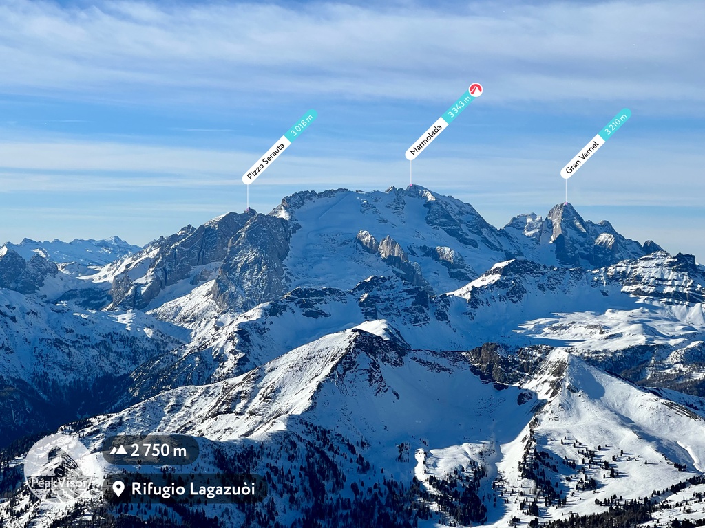
Marmolada (3,342 m / 10,968 ft) “is the highest mountain in the Dolomites and the most prominent at the same time also called "The Queen" of these mountains. With the prominence of 2,130 m (6,995 ft), it is one of the 22 ultra mountains in Italy and the only one with a large glacier on the top, which doesn't melt in the summer.
The two highest peaks of Marmolada are Punta Penia (3,343 m / 10,968 ft) and Punta Rocca (3,310 m / 10,860 ft). The third highest peak in the group, the Gran Vernel (3,210 m / 10,531 ft), is also a number 9 by elevation in the Dolomites.
There are many ways to admire the beauty of this group but I prefer a ridge trail which goes from Passo Pordoi, along the peaks of Col del Cuc (2,559 m / 8,396 ft), Sass Ciapel (2,256 m / 8,389 ft), Sasso di Mezzodì (2,036 m / 6,680 ft), and ends up at Mesolina (2,642 m / 8,668 ft).”
Antelao (3,264 m / 1,733 ft), “which is also called the "King of the Dolomites" reminds you of a chess game: it is the second to the Queen of the Dolomites. There is also a glacier on the northeast side of Antelao. It is divided into two sections called Ghiacciaio Superiore and Ghiacciaio Inferiore, respectively.”
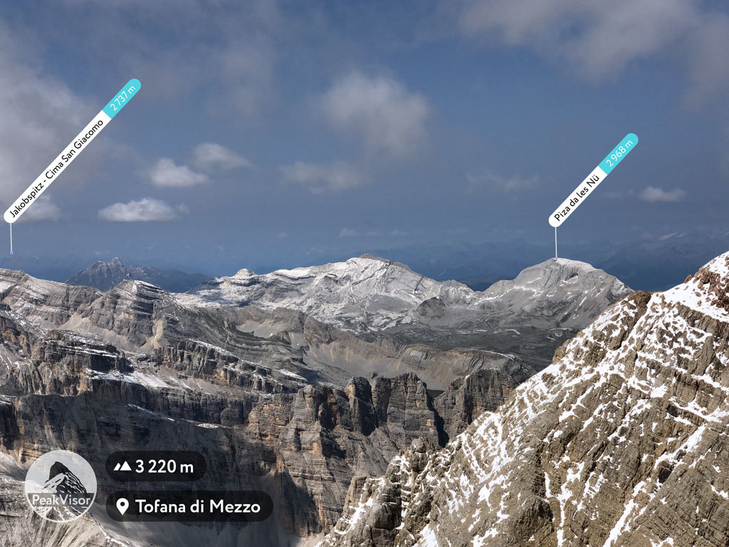
Tofane (3,244 m / 10,643 ft) is a relatively small, but historically and geologically important and very popular among tourist groups, peak located also in the very heart of the region, making it one of the best natural viewpoints in the Dolomites.
In particular, you can enjoy the 360-degree views of the “Pale Mountains” from the highest and the most prominent peak of the group, Tofana di Mezzo (3,244 m / 10,643 ft). Two other famous peaks are Tofana di Dentro (3,238 m / 10,623 ft), Tofana di Rozes (3,225 m / 10,580 ft).
Cristallo (3,221 m / 10,567 ft) is an incredibly beautiful group located to the northeast of Cortina d’Ampezzo that’s home to Monte Cristallo. Another great summit of the group in the list of the mountains higher than 3000 m (9,842 ft) in the Dolomites is Piz Popena (3,153 m / 10,344 ft).
Civetta (3,220 m / 10,564 ft) is also one of the best-known groups in the Dolomites thanks to its north-western face, with its 1,000 m (3,280 ft) cliffs and its large size compared to some other groups. The mountain also attracts tourists thanks to the large skiing area and two lakes: Alleghe Lake at the foot of the group and the Coldai Lake right in the mountains.
Sorapiss (3,205 m / 10,515 ft) is a group in the Veneto region between Cortina d'Ampezzo and the Cadore that attracts thousands of tourists a year, not so much for its highest point Punta Sorapiss (3,205 m) but for Lake Sorapiss. Together the lake and the mountain group form a landscape of incredible beauty in which everyone dreams to be.
The Pala Group (3,192 m / 10,472 ft), or the Pale of San Martino, is the largest mountain group in the Dolomites. It has a total area of 240 km² / 92 mi² or about 34,285 soccer (football) fields.
The highest and the most important summits are Cima della Vezzana (3,192 m / 10,472 ft) and Cimon della Pala (3,183 m / 10,446 ft), which is sometimes called the Matterhorn of the Dolomites dominates the landscape.
The main feature of the Langkofel / Sassolungo (3,180 m / 10,436 ft) group is the largest high altitude plateau in EuropeL Seiser Alm / Alpe di Siusi.
There is also a loop hiking trail that passes through the region with views of other neighboring mountains, as well as the extensive skiing area in the Fassa Valley, part of the Dolomiti Superski system. It has trails for all skill levels.
Pelmo (3,172 m / 10,407 ft) is a giant lone-standing mountain close to Civetta, which is also called "The Throne of God" or "The God's Armchair" by the locals because of its tower-like form.
It was one of the first Dolomite peaks to be climbed by English climber John Ball, who also wrote the first cartographic guide to the whole region. The Pelmo is also famous because of the traces (prints in the rocks) of at least three dinosaurs that are around 220 million years old.
Sella (3,152 m / 10,338 ft) is one of the most important groups in the Dolomites. It is a huge hand-built rock fortress in the middle of the Alpine meadows.
At the same time, it is one of the major centers of outdoor activities in the Alps, as it is home to one of the longest ski circuits in the world, Sellaronda. Piz Boè (3,152 m / 10,338 ft) is the highest mountain. The best way to admire the beauty of Sella Towers and Piz Boe itself is to take a cable car from Pass Pordoi.
Sexten (3,151 m / 10,338 ft) is a vast group in the very north of the Dolomite Alps on the border with Austria, whose highest peak is Punta Tre Scarperi (3,151 m / 10,338 ft). There are 141 named mountains in the group located all over Tre Cime Nature Park.
In addition to the aforementioned highest mountain groups and individual peaks above 3,000 meters (9,842 ft), several other places in the Dolomites are just as or even more famous for their unusual shapes, rather than their height compared to other mountains. Here are some of the most notable:
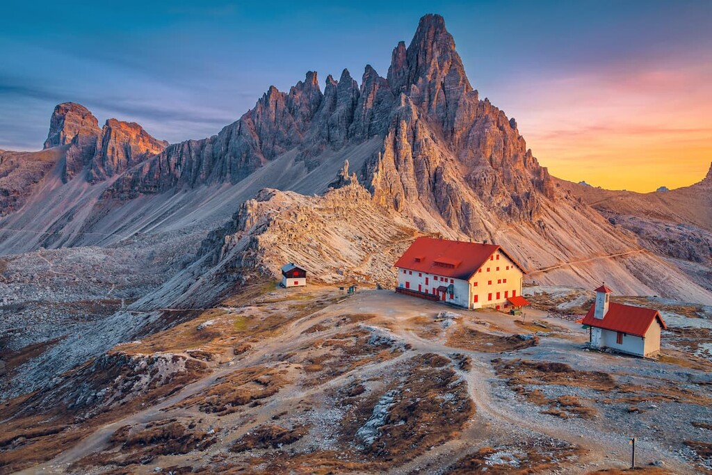
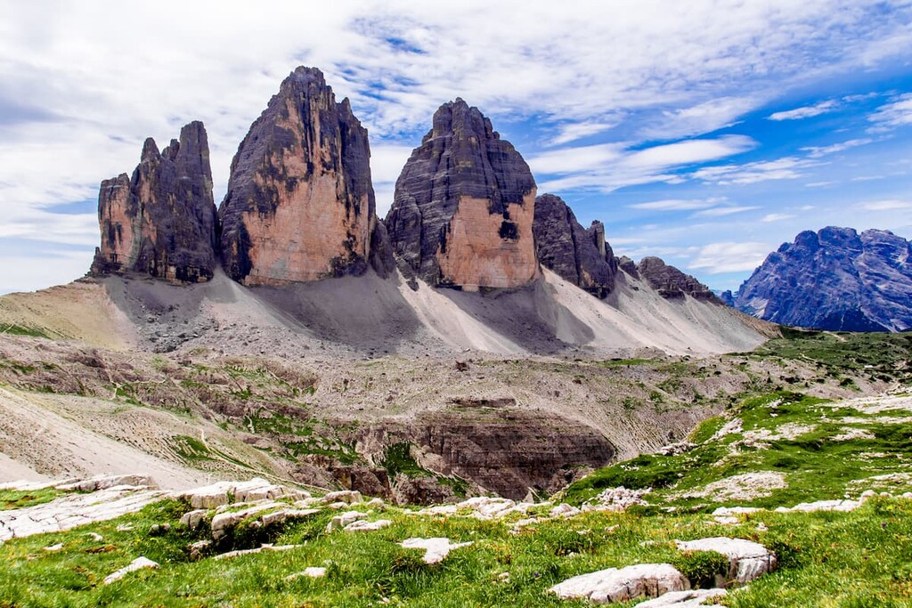
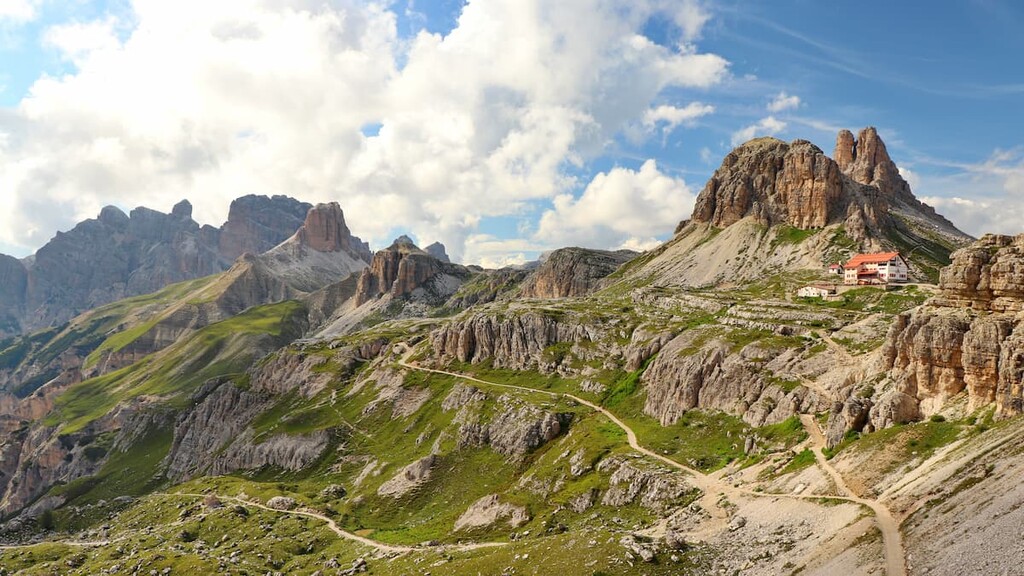
Tre Cime di Lavaredo (2,999 m / 9,839 ft) is the most unusual-looking mountain in the Dolomites with three sharp teeth-like summits. Therefore, it is the most popular and recognizable.
It is also the symbol of the Italian Alps as Tre Cime is the image that’s printed on most of the postcards, calendars, posters, book covers, and souvenirs. The highest and the most prominent mountain is Cima Grande (2,999 m / 9,839 ft), which is one of the Six Great North Faces of the Alps (a vertical or sloping side of a mountain).
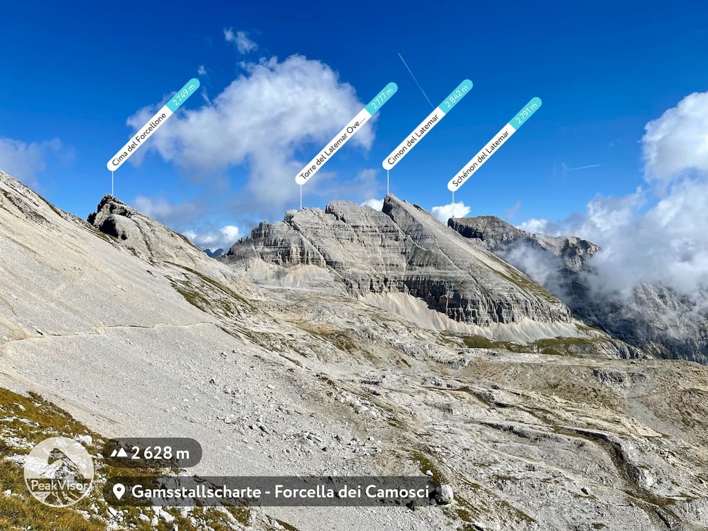
Latemar (2,842 m / 9,324 ft) is another relatively small but well-known mountain group. The main feature of the group is the view of its peaks from the shores of the beautiful Carezza Lake, which is surrounded by dense spruce forests. The highest and most prominent peak is Cimon del Latemar (2,842 m / 9,324 ft) with 1,090 m (3,576 ft) of prominence.
Rosengarten / Catinaccio (3,004 m / 9,855 ft) is located just east of Bolzano. According to PeakVisor’s founder, “the highest rock in this group is Kesselkogel (3,004 m / 9,855 ft) or Catinaccio d'Antermoia in Italian. It requires solid climbing skills to conquer. Rifugio Vajolet, which is surrounded by Vajolet Towers, is a popular hiking destination with epic scenery.”
Puez (2,918m / 9,573 ft) is one of the most famous groups in the Dolomites. It is bounded by the two Ladin valleys—Gardena Valley in the south and by the Badia Valley in the east. The most important mountains of the group are Piz de Puez (2,918 m / 9,573 ft), Col de Puez (2,723 m 8,933/ ft ), Sassongher (2,665 m / 8,743 ft).
Peitlerkofel (2,875 m / 9,432 ft) “is a hidden gem of Puez-Odle Nature Park which is often overlooked by visitors yet its views from Passo delle Erbe are stunning, it is one of the best sunrise spotting locations."
Geisler / Odle (3,025 m / 9,925 ft), or the Gieslergruppe, is situated to the northeast of Bolzano. “One of the most popular spots among the photographers in the group is the summit of Seceda (2,519 m (8,264 ft), which is easily reachable with a cable car from the city of Ortisei.
The dramatic transition from the tilted green plateau to the numerous rocky towers that look like dragon teeth is a must-visit spot. You could explore these towers from an overlook in the village of Funes.
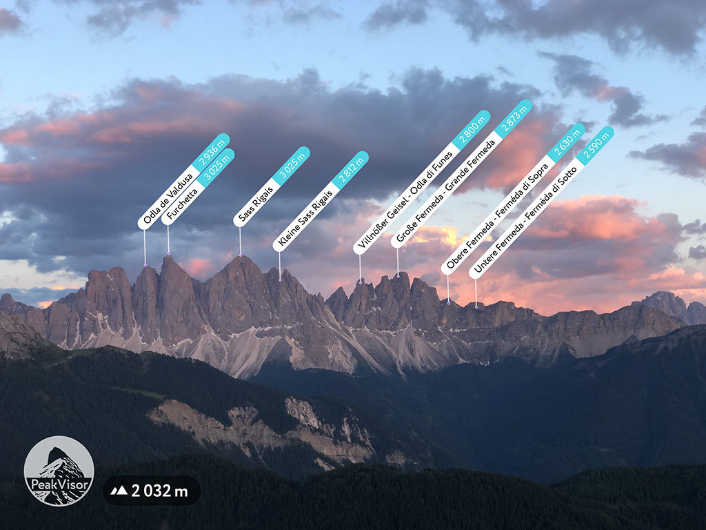
Seceda is a convenient starting point for many trails leading into Puez-Odle Nature Park. The other most known peaks in the park are Furchetta (3,025 m (9,925 ft), Sass Rigais (3,025 m / 9,924 ft), Grande Fermeda (2,873 m / 9,426 ft).”
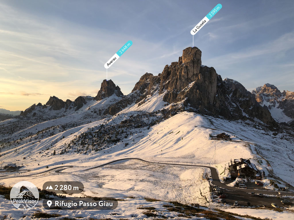
Nuvolau (2,648 m / 8,687 ft) is located to the southwest of Cortina d’Ampezzo. It “is known for its highest peak Averau (2,648 m / 8,687 ft), which is accessible by via ferrata only, which allows visitors to see all major peaks in the Dolomites at one place.
The first rifugio Nuvolau (1884) in the Dolomites located just nearby Nuvolau (2,574m / 8,445 ft) peak. In 2021, it was sold by its owners after decades of management.
There is also a very famous small group of mountains called Cinque Torri (Five Towers), which stands in the middle of an alpine meadow. The name speaks for itself, but do not confuse it with the Cinque Terre National Park in Liguria (Terre are “lands” in Italian).
Fanes (3,064 m / 10,052 ft) is another famous group without which it is impossible to imagine the Dolomites. The highest and the most prominent mountain in the group is Piz dles Cunturines (3,064 m / 10,052 ft).
But the most famous peak is Lagazuoi with the unique historical rifugio Lagazuòi at the top and a cable car leading to it from the fantastic Falzarego Pass attracting hundreds of people each day.
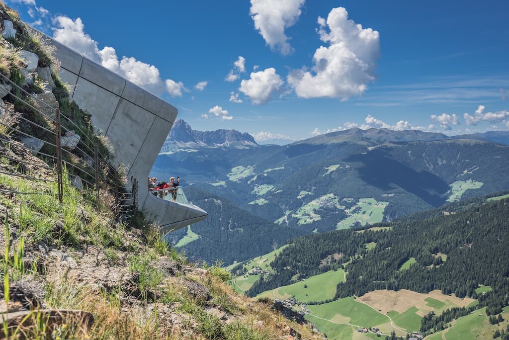
Kronplatz (2,275 m / 7,464 ft) “is a popular destination for families. It is reachable by cable cars from several directions. It offers panoramic views, relaxed hiking, and a gem of Alpine architecture—the Messner Mountain Museum.”
The Dolomites are covered with an incredible network of paths that connect valleys, passes, and mountain peaks. But the most interesting is that many of them are united in a single system, where each significant trail is numbered and there are signposts on the trails, so you don't get lost on the way.
My advice: In addition to the many features of PeakVisor, always use paper maps from Tabacco or Compass, which are two of the main publishers of such maps in Italy. With that in mind, here are some of the best places to visit in the Dolomites:
The main hiking areas in the Dolomites are represented by one national park, 8 regional nature parks and two geoparks.
National Park of Belluno Dolomites
National Park of Belluno Dolomites is one of the 25 national parks of Italy and is the only one located in the Dolomites between the towns of Feltre, Belluno, Fiera di Primiero and Agordo.
The area of the park is 32 sq km (12.3 sq mi), which covers the Cimonega Group and groups in the Belluno Dolomites. The park also includes unique flora and fauna that is protected by the state.

Nature Parks
In addition to a national park, the Dolomites have regional nature parks of smaller size, but equal importance. They are usually located within one or more mountain groups. These include:
Bletterbach Geopark
Bletterbach Geopark is one of the two geoparks in the Dolomites, together with Adamello Brenta Nature Park, which is also a geopark in the worldwide Unesco Global Geoparks Network. The system was created to preserve the planet’s geological heritage. In total, there are just 75 such parks in Europe in 26 countries, and 161 parks in 44 countries worldwide.
There are more than 20 long hiking trails in the region of various distances and times from 2–3 days to 14 days of hiking.
Alta Via
The Dolomites are famous primarily for their long hiking trails called Alta Via (“The High Route” or “The High Way”, via is also a “street” in Italian). The name of the route references the fact that you can stay many days at high elevations of up to 2,500 m (8,202 ft) but the elevation difference could be from 1,000 m (3,280 ft) to 3,342 m (10,964 ft) on the Marmolada—the highest peak of the Dolomites.

These types of routes in English are also often called "hut-to-hut hiking." However, in Europe, the word "trekking" is used to describe such activity.
A typical day on Alta Via looks like this:
In other words, it is an extraordinary outdoor and life experience you would never have on normal day hikes here in the Dolomites, or an area of your living.
Then, another undoubted advantage of Alta Via is that they allow you to see all the main mountains of the Dolomites on one hike on a normal vacation time of two weeks. That is why these routes are popular also among travelers from other countries. On the trails, you will meet not only Italians and Germans, but also many Americans, Englishmen, Australians, or, for example, Russian travelers.
Speaking about the exact routes, the Alta Via 1 and Alta Via 2 are undoubtedly the most popular ones. Both are located in the very central part of the Dolomites: The first is the western one, and the second is the eastern one compared to each other. They both go through all the most beautiful mountains: Braies Dolomites, Sella, Marmolada, Lagazuoi, Pelmo, Civetta, Cimonega, and many others.
The Alta Via 2 is also a special route called “The Way of the Legends” because it goes through many places mentioned in local fairytales of the Ladin people—for example, the remote high glacial valleys of the Vette Feltrine area.
The level of difficulty of these routes is from moderate to difficult. But you can hike Alta Via even if you are a beginner hiker, it will just take a lot of effort.
Here are the exact routes of both trails and the basic technical information that will allow you to decide whether to hike one of the Alta Via:
Alta Via 1
Alta Via 2
Now the most interesting part about Alta Via: There are not only two routes—it is a whole series of trails that also includes Alta Via 3, Alta Via 4, Alta Via 5, Alta Via 6. These Alta Via pass through the more eastern part of Dolomites compared to routes 1 and 2, and there are definitely fewer tourists on them, but the trails are also great.
There are also two additional and even less known and popular trails—Alta Via 7 and Alta Via 8. The latter is also called "The Alta Via of the Heroes" because it runs through areas of the World War I battlefields and summits in the provinces of Feltre, Treviso, and Vicenza like the Monte Grappa (1,776 m / 5,826 ft), for example.
Here are the routes and lengths of the remaining six trails:
There is an exact season for hiking all of these tralis: It is from June 20–21 until September 20–21. This is the time when most mountain huts (and cable cars—you may need to use them to save energy) are open. It means you can’t hike Alta Via before or after this period on a hut-to-hut basis.
The season is the three summer months in the Alps when there is no snow on the trails, passes, and summits (except Marmolada). But there still could be some snow or snowing at the beginning of June or at the end of August or the very first days of September. For example, there was a huge snowfall on September 8–10, 2019.
The mid-summer is the opposite thing: It could be +30 degrees Celsius (+86 Fahrenheit) in the valleys, and around +12...+15 Celsius (+54...+186 Fahrenheit) at night, which is quite high—usually it is 0 to +10 Celsius (+32 to +50 Fahrenheit) like it was when I hiked Tre Cime di Lavaredo Loop in the middle of July 2017. From my experience, the best time for hiking is the beginning and the end of the season.
Speaking of the cost, the whole Alta Via 1 and Alta Via 2 trails will cost you from €500 to €1000 for rifugios with food, plus additional expenses on lunch food and water during the hiking, transportation to Italy and the Dolomites. In my opinion, this is a very modest price for exactly one of the best hikes (and travels in general) of your life—to the most beautiful mountains in the world.
Loop Trails
The second most popular group of trails in the Dolomites are the loop trails, which go around specific mountain groups. The most famous trail is the Tre Cime di Lavaredo Loop around the mountain group of the same name. It takes about 4 hours if you can resist the temptation to admire the nearest mountains and side trails.
Other popular trails go around the mountains Civetta, Pelmo, Sassolungo, Pale di San Martino (Palaronda Trek), and Brenta Group (Dolomiti di Brenta Trek).
Thru-hiking Trails
The third group of trails is very long trails that pass through the entire Alps, through all of Italy, or between individual countries, passing also the Dolomites, where you can walk individual sections of the trail.
Some of the best-known trails are the Italy Trail (Sentiero Italia), Parks Trail (Sentiero dei Parchi), The Road of Claudius Augustus (Via Claudia Augusta), The Way of Peace (Sentiero della Pace), The Alpine Way (Via Alpina), and some others.
In other words, if one day you want one of these trails, you will find yourself in the Dolomites, too.
Last but not least, a good idea for a trip to the Dolomites that doesn’t involve very difficult and/or long hiking is to visit some interesting and beautiful places. These include, for example, museums, cable cars, and panoramic viewpoints.
Museums
In the Dolomites, there are a lot of thematic museums for those who are interested in certain issues. Here are three of the most important and popular museums:
Discover more interesting museums at VisitDolomites.com.
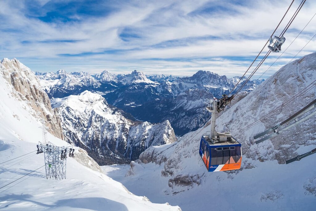
Cable Cars and Cog Railways
According to PeakVisor’s founder, “the Dolomites have arguably the most advanced and densest network of cable cars in the region. Going to the Dolomites, you will find a cable car almost everywhere, but here are the most important ones:
Viewing Platforms
Finally, in the Dolomites, there are several special observation decks with 360-degree panoramic views, although, of course, if you climb almost any of the peaks you will find such views. These places are different because they are located in spots where you can see as many mountains as possible, including the most popular ones. Here’s their list of the most important viewpoints:
The platforms, or “balconies” or "terraces," as they are called here, are also equipped with information boards on which all the surrounding peaks are signed. By the way, it was from this one of these stands from where the story of the PeakVisor began, when the founder decided to recreate this feature in a digital environment using augmented reality, so you can have this kind of information with you wherever you go in the mountains.
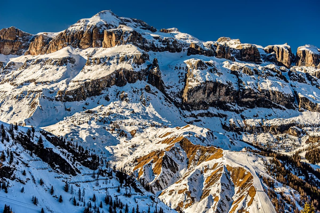
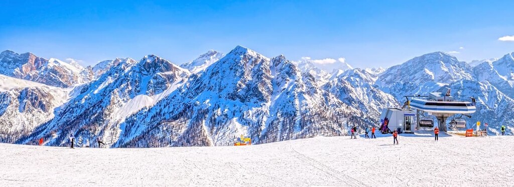
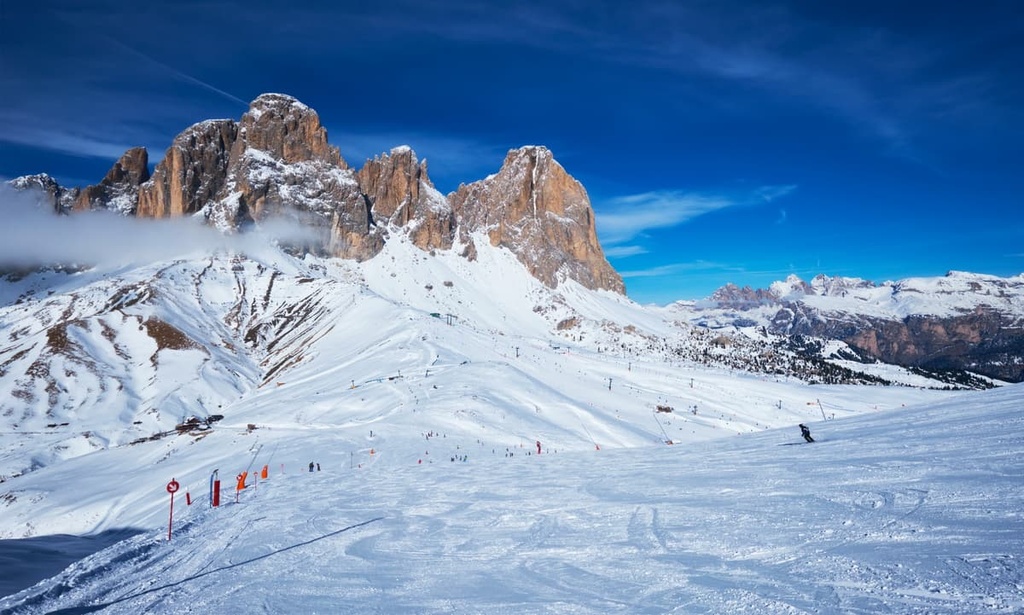
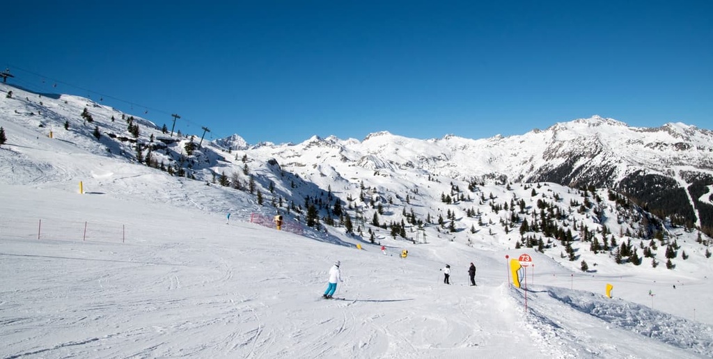
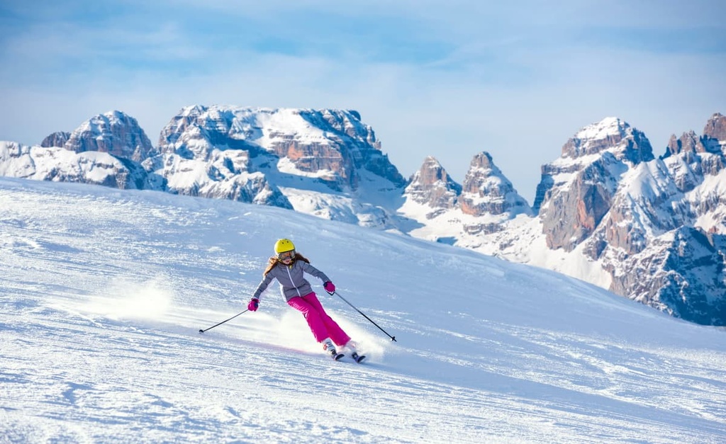
There are two tourist seasons in the Dolomites: summer and winter. While summer belongs to hikers, mountaineers, and cyclists, in winter, the area is dominated by skiers and snowboarders.
The Dolomites are considered one of the best places in the world for skiing and snowboarding and other winter activities because of the incredibly beautiful mountains and developed modern ski and tourist infrastructure with centuries-old traditions and always high quality of service.
There are several dozen ski resorts and ski areas in the region, which can be divided into three large groups:
The ski season for all areas is the same due to their location in the Alps: It is from late November or early December until late March or early April depending on the snow and weather conditions. The general opening times of slopes: 8:30 am to 4:30 pm.
Update for 2021–22 ski season in the Dolomites: Most of the ski resorts are open again after the shortened last two seasons.
However, in order to ski the slopes, use the ski lifts, eat at the restaurants and bars, and check into hotels, and so on, you will need a Green Pass—a local health certificate.
Ski resorts also may have various restrictions. For example, in Skirama Dolomiti, according to information available on November 27th and 28th 2021, "lifts pass sales for Saturday and Sunday will be limited to a maximum number of 1,000 skiers per day. Skirama seasonal pass holders will also need to make a ski reservation to access the slopes." Check the resorts’ official websites before heading to the slopes.
In the following I will briefly describe all three groups of resorts:
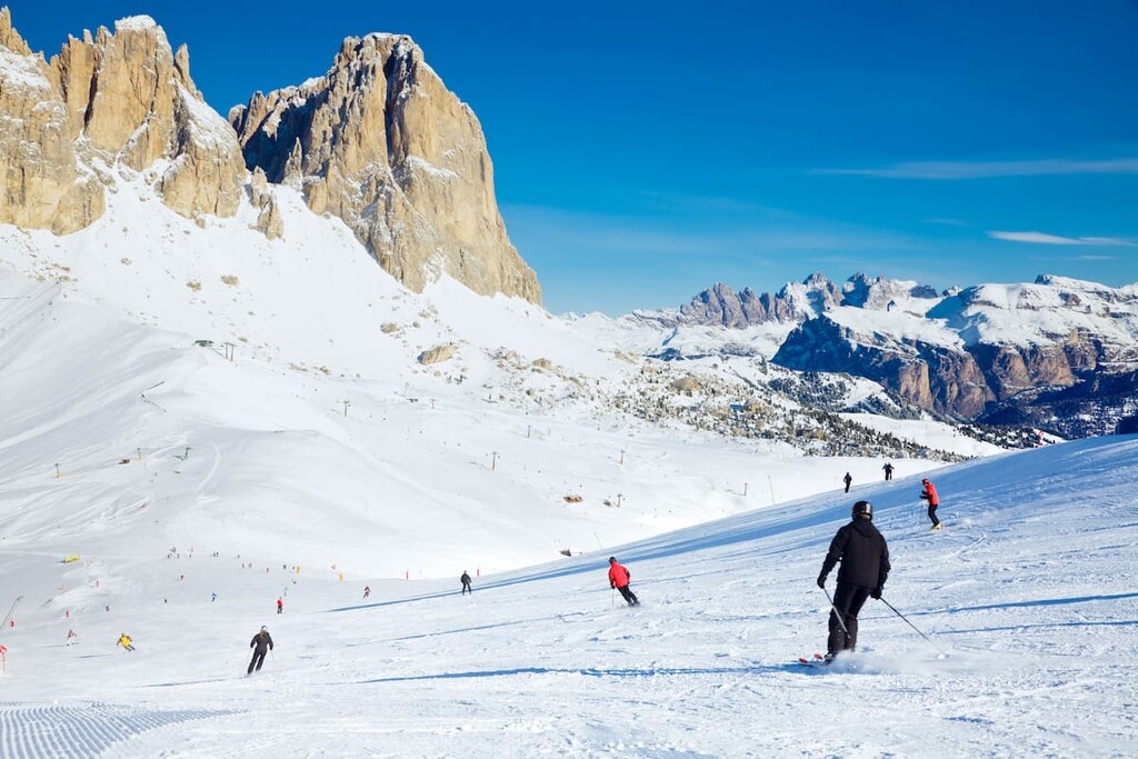
Dolomiti Superski is the main and the largest system of ski resorts in the region, which means you can move from one to another, using ski lifts or ski buses that take skiers from hotels directly to the slopes. At the same time this is the second-largest ski area in the world after the Three Valleys in France (Les 3 Vallées: Val Thorens, Les Menuires, Méribel, Courchevel, Brides-les-Bains, Saint-Martin-de-Belleville, and Orelle) which aims to become the first. So far it lacks only about 100 km (mi) of continuous pistes to surpass the Three Valleys (600 km / 372 mi).
In all, the system has 12–16 major ski areas, 1.200 km (745 mi) of slopes (500 km / 310 mi of which are connected to each other), and 450 lifts. The exact number of resorts varies, even according to the official site because usually several smaller ski areas are combined in pairs. They are also constantly evolving: new slopes, ski lifts, and so on are added.
Here is an accurate list of resorts:
The Dolomites are superbly rich in interesting ski routes. The most famous is called Sellaronda. It runs around the whole Sella Group. Its length is about 40 km (24.8 mi). This is also one of the longest non-stop ski trails in the world.
In order to ski at Dolomiti Superski, you need only one skipass, which is valid for all resorts. Ski passes come in three basic types: for one day of skiing, for several days, and for the entire winter ski season. At the time this section of the guide was updated, for the 2021–22 season, the cost of Dolomiti Superski ski passes for adults is as follows:
The cost depends on the beginning of the season or its peak. The cost for teenagers, children, seniors, and families is lower.
The official website of Dolomiti Superski: Dolomitisuperski.com.
Skirama Dolomiti Adamello Brenta or simply Skirama Dolomiti is a ski system similar to Dolomiti Superski, located southwest of the latter in the isolated Dolomiti di Brenta mountain group as well as its neighboring groups, in particular the Adamello-Presanella Alps.
For the length of trails and the number of lifts, this system is exactly three times smaller (380 km / 236 mi of slopes and 150 ski lifts) than the Dolomiti Superski. At the same time, it is slightly less known among skiers and travelers from abroad, like the Brenta Group itself. However, its main village and main resort, Madonna di Campiglio, is just as famous as Cortina d’Ampezzo, the main resort of Dolomiti Superski, among locals, especially from Milan and other cities in northwestern Italy, because they are closer to going here, and the mountains are no less impressive.
You can also ski in this system, or ski carousel as they are also called, by going from one resort to another directly on skis, on ski lifts, or in a special bus.
Skirama Dolomiti Adamello Brenta includes eight ski resorts and ski areas. Here is their exact list:
As in Dolomiti Superski, there are a lot of interesting pistes, as well as ski lifts, and every few years new ones appear.
For example, for the 2021–22 season in Madonna di Campiglio, there is a new lift Fortini-Pradalago, which was built in place of an old one for the red ski trail of the same name, Fortini, with the starting station at 1,644 m (5,393 ft) and arrival station at 2,100 m (6,889 ft). The height difference is 456 m (1,496 ft), the length is 2.4 km (1.4 mi).
In order to ski in Skirama Dolomiti, you also need only one skipass, called Superskirama Skipass, which is valid for all the resorts. But, unlike the Dolomiti Superski, here you can buy a skipass from two days to two weeks, and for the entire season. At the time this section of the guide was updated, for the 2021–22 season, the Skirama Dolomiti adult skipass price is as follows:
In general, the longer you ride, the cheaper the day. There are also discounts for teens, children, seniors, and families.
Official website Skirama Dolomiti Adamello Brenta: Skirama.it.
In addition to the two large ski systems in the Dolomites, there are about a dozen smaller individual ski resorts. It is usually located on the borders of the region or in neighboring mountains, from where you can also see the Dolomites while skiing, but can pay less for a skipass and save on accommodation and travel to these places. In my opinion, brilliant!
The "minuses" of these resorts should include a smaller number of slopes (sometimes only two–three slopes), lower altitude difference, and the like.
For example, in my home Feltrino region in the Dolomites, there are two small ski resorts:
In comparison, a day ticket to the Monte Avena Ski Resort costs €23 for adults—half the price of a skipass to Dolomiti Superski. In Lagorai, skipass for adults costs €229—almost four times less than in the Skirama Dolomiti.
Check the Dolomites ski resorts map on the larger Trentino-Alto Adige/Südtirol and Veneto ski maps of Italy in the World Mountain Lifts section of the site. It includes information about open ski lifts / slopes in the Dolomites in real-time with opening dates and hours. There are also year-round cable cars, funiculars, cog railways, aerial tramways, and all other types of mountain lifts.
As the Dolomites is not a single region in terms of administrative division, you will not find one official site or portal where all the information is collected about these mountains. There are a lot of sites, in which it is very easy to get confused in search of an answer to your question.
I will note here a few of the most important official resources you can trust:
You will also find websites of individual regions, other valleys, some attractions, cities and villages, which usually also have information points, where you can get a detailed paper map, additional services, rent equipment, and complete other similar tasks.
There are three main types of temporary accommodations you can stay in while hiking and climbing in the Dolomites:
Mountain huts are half-hotels-half-hostels, as I usually call them, at elevations of 1,000 to 2,700 m (3,280 to 8,858 ft). Here you can rent a bed in a shared room for 4 to 12 people, as well as to have shower and order hot lunch and an Italian breakfast.
Accommodations cost €50 to €100, depending on the popularity of the place, but usually no more than €60 to €65 with food, and €20 to €25 without food. In Italian these huts are called "rifugios."
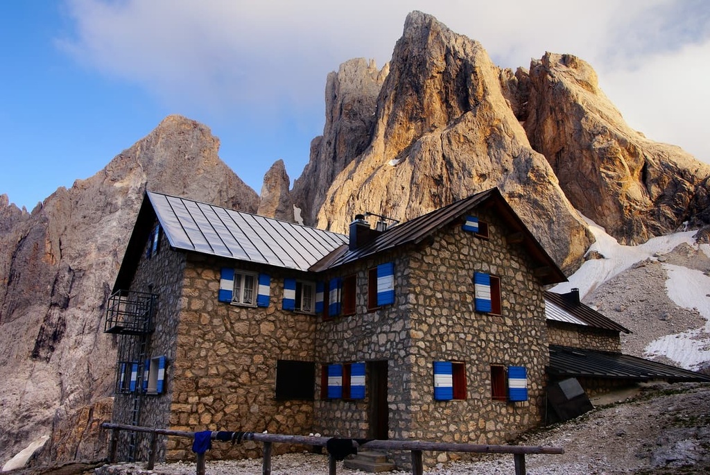
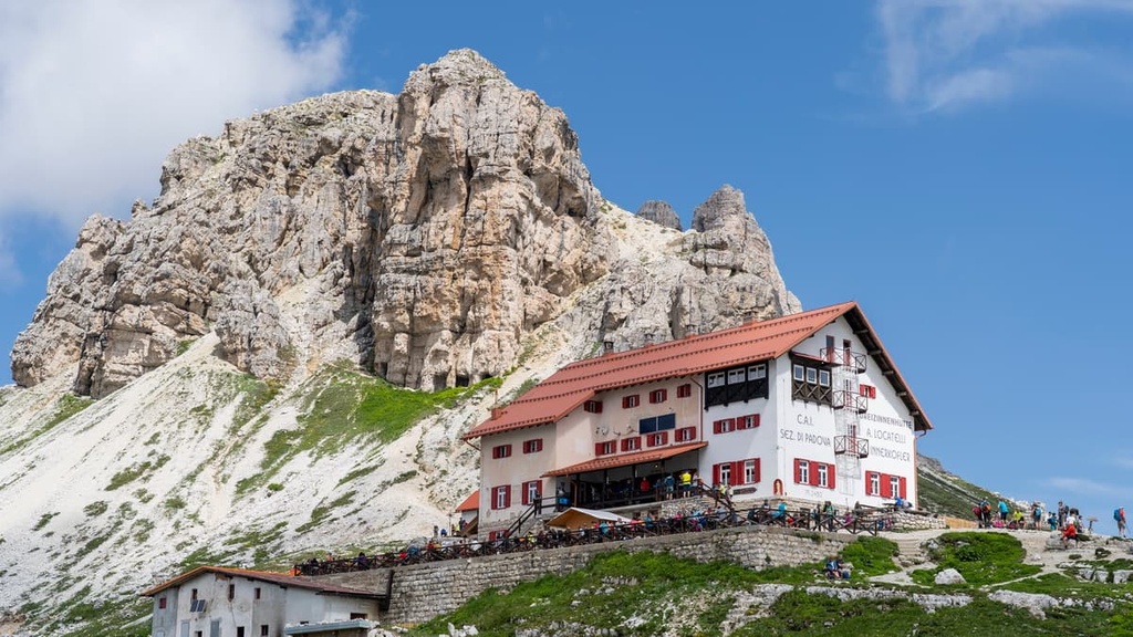
There are between 300 and 400 such huts in total in the Dolomites (of more than 1000 in the Italian Alps), the most famous of which are located at the most famous and popular mountains, passes and valleys. These include, for example:
You can choose any of these huts, they have about the same very high level of service. At the same time, these rifugios are not some hotel chain—each hut has a unique history and its own characteristics.
Bivouacs are free small shelters ("bivacco" in Italian) made of metal, wood, or stone (or a combination of materials), that are scattered around the Dolomites here and there by the Italian Alpine Club (Club Alpino Italiano, CAI) and other similar organizations.
Some bivouacs are located right on the peaks at an elevation of more than 3,000 m (9,842 ft). The shelters have from 2 to 10 beds, but often in one room. They are always open regardless of the season but may be inaccessible because of snow. They are usually occupied by climbers or adventurers.
I have stayed in two such bivouacs, both of which I highly recommend: bivacco Marco dal Bianco on the Ombretta Pass (2,700 m / 8,858 ft) and bivacco Renato Reali at the foot of Croda Granda (2,848 m / 9347 ft) in Pale di San Martino.
By the way, bivouacs and mountain shelters, as well as some other types of accommodation, are marked on the PeakVisor maps as the nearest places to stay next to your favorite mountains.

These are the campsites you can find in other parts of the world, there are many of them in the Dolomites, too, but not as many as in other places. Campsites are usually located near nature parks. They are simply a place for setting up a tent at night and they usually cost no more than €15.
The campsites are suitable for bascamping, too. An example of a good camping destination is camping “La Marmolada” at the locality Malga Ciapela at the foot of the Marmolada Group.
Officially it is forbidden to pitch a tent just anywhere you want in the Dolomites by laws in both the regions of Veneto and Trentino / South Tyrol, as well as in Italy in general.
However, there is a loophole in the law that allows you to camp temporarily before sunset if the night catches you on the road (and you somehow took a tent with you). You should also leave the place at sunrise. In any case, do not camp in one place for more than 48 hours.
The Dolomites have all the other types of accommodations you can easily find in towns and villages, including hotels, guest houses, rooms, and apartments on Airbnb.
The cheapest option is the regular B&B, where a room costs about €25–30 per person, per night with breakfast. Usually they are owned just by local families, which are in general very nice to meet. Many of these hosts are also great people to ask for advice about your adventure. An example of such a typical B&B is Bunaceve in my home town of Lamon.
According to the founder of PeakVisor, "exploring the Dolomites while staying in small Alpine villages and even smaller remote hamlets might be the most convenient way. Nevertheless there are several thriving cities which must be on every traveller’s itinerary:”
Belluno is the capital of the province of the same name in the Veneto region, located 100 km (82 mi) from Venice in the huge Valbelluna Valley. From here it is convenient to hike in the mountains of the Dolomiti Bellunesi National Park, to the Agordo region and other neighboring areas. The town has a population of 36,000 people (2017).
Near Belluno, there is also the slightly smaller town of Feltre, which is also considered the second main town of the Republic of Venice (now region) in the Dolomites and the gateway to these mountains from the south. The municipality of Feltre also includes about 12 smaller settlements, of which I will note my native Lamon once again.
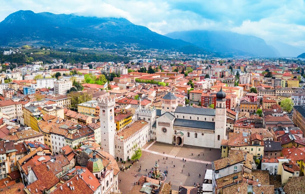
Trento is the capital of the province of Trentino in the Trentino—Alto Adige / South Tyrol region. It is located 100 km (82 mi) from Verona in the Adige River Valley.
It is a convenient starting point for hiking in the Dolomiti di Brenta mountains, the Garda Mountains, and the neighboring Valsugana Valley of Lagorai chain. The population of the town is 117,000 (2017). Other important towns nearby include Rovereto, Molveno, Borgo Valsugana, Asiago, and others.
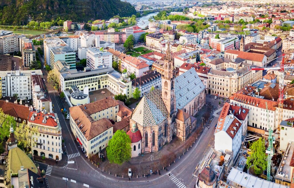
Bolzano is the capital of the province of Bolzano / South Tyrol, which is in the same region as Trento, some 123 km (76.4 mi) from Innsbruck, Austria. The nearest major attractions are the Seiser Alm Valley (Alpe di Siusi), which is the largest high-altitude Alpine meadow in Europe, Kronplatz mountain, Schlern-Rosengarten Nature Park, and others.
The city has 106,000 inhabitants (2017). As alternatives to Bolzano, I would recommend the smaller Merano, Bruneco and Brixen.
Cortina is the most important and popular village in the Dolomites, and it is also considered the capital of the region, despite its more modest size compared to other cities. The fact is that the local and foreign notables have taken a fancy to the city as a place to relax and engage in winter sports. Major winter sports competitions are taking place here, including the future Winter Olympics in 2026.
At the same time, Cortina is one of the primary Ladin villages. In addition to it, there are also the Ladin villages of Corvara di Badia, Livignolo Col di Lana, Arabba, Canazei, Predazzo, and Merano, among others.
All these settlements are clearly associated with the Dolomites, so you can choose one or several of them to start your trip in the most beautiful mountains in the world.
Explore The Dolomites with the PeakVisor 3D Map and identify its summits.