
Scan the QR code and open PeakVisor on your phone
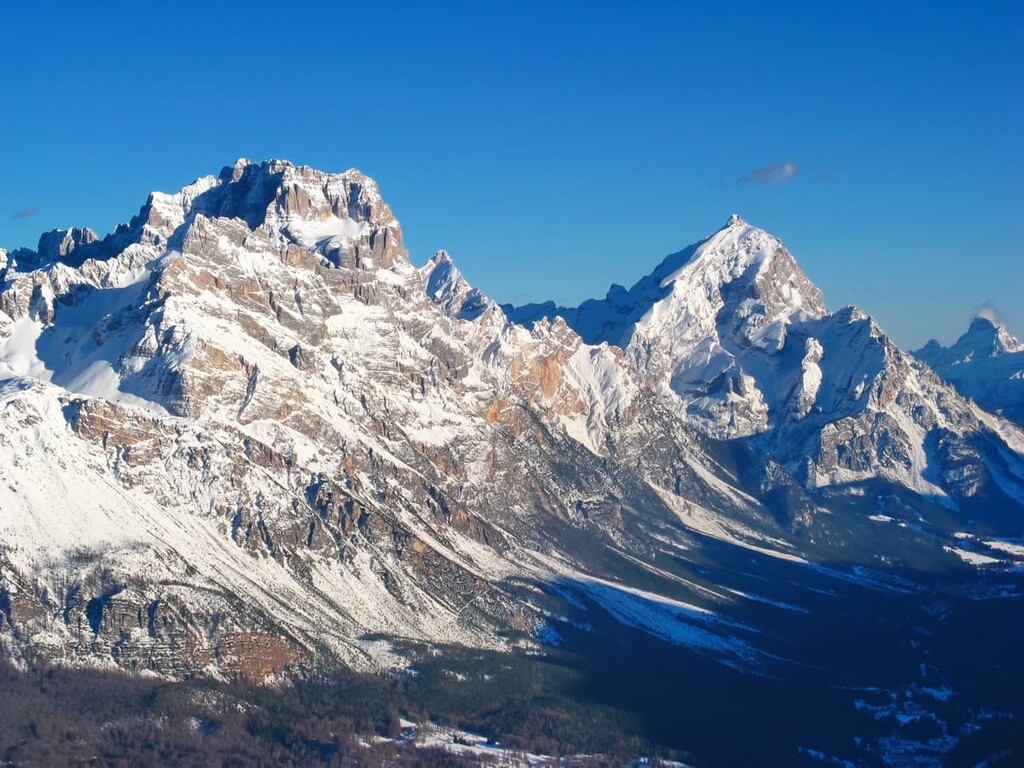
The Gruppo del Sorapiss include 8 named peaks. The highest is Punta Sorapiss at 3,205 m. Other notable peaks include Zurlon, Croda Marcora and Punte Tre Sorelle.
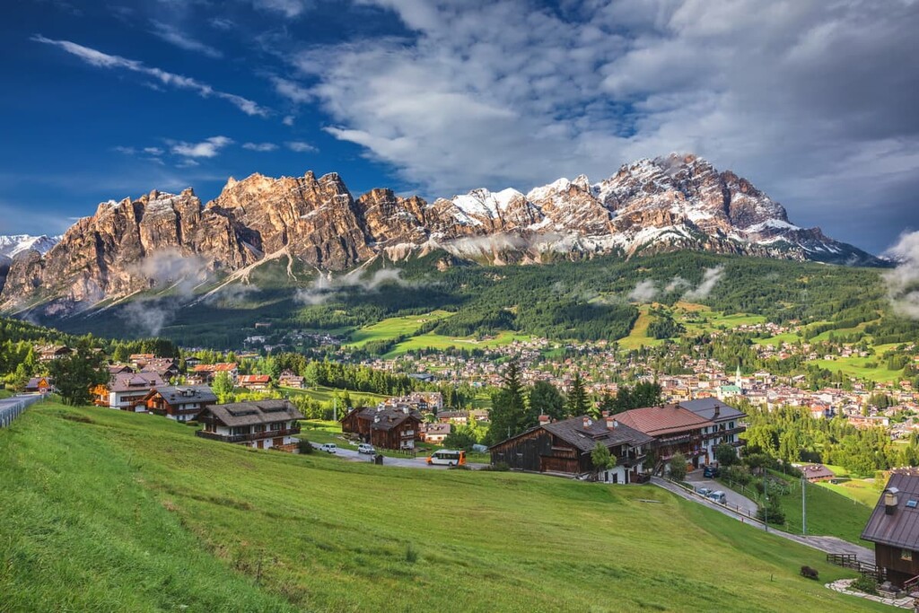
The Sorapiss Group (Gruppo del Sorapiss) is a relatively small collection of peaks located in the East Dolomites of northern Italy, but no less famous and attractive for outdoor enthusiasts than its larger counterpart. Even if you haven't been here yet, you may already have seen these mountains on two classic postcards of the Sorapiss Lake and Misurina Lake. In total, there are 8 named mountains in Gruppo del Sorapiss, the highest and the most prominent of which is Punta Sorapiss (3,205 m / 10,515 ft).
The name of the impressive mountains of the Sorapiss group comes from the Ladin word sopišs, which means a place, such as a hollow or a small lake (cioè sotto la cascata in Italian), that forms below a huge waterfall. So the name of the group roughly translates to “under the waterfall."
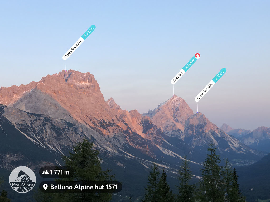
Indeed, there are plenty of waterfalls in the area. The largest one, the 50 m (164 ft) high Cascata delle Pile, is located in the Oten Valley (Val d’Oten) to the south of the Sorapiss Group between it and Mount Antelao (3,264 m / 10,708 ft).
Therefore, to this day, the name of the group is sometimes spelled in the Ladin manner not with two “s” but with one (Soràpiš), just as in the Ladin language. The Ladins are the native people of the Dolomites, who in addition to their language, also have their own traditions, culture, legends, and cuisine. They live mainly in five valleys in the Dolomites, one of which is the Ampezzo Valley, which is home to the city of Corina d’Ampezzo.
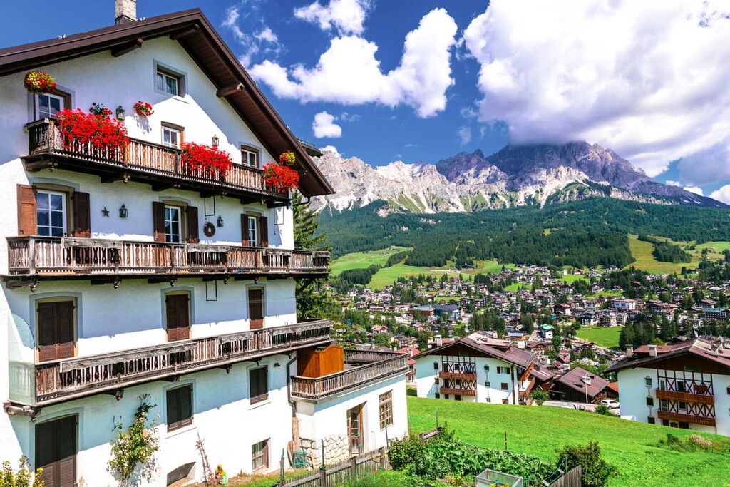
The Sorapiss Group is located in the municipalities of Cortina d’Ampezzo, San Vito di Cadore, and Auronzo di Cadore in the province of Belluno in the Veneto region in northern Italy.
To the southeast, the group borders the Marmorole Group. Together these two ranges could form one large group if they were not separated by the Forcella Grande Pass, which you can traverse only by foot.
Second, to the south of Sorapiss—through the Forcella Piccola Pass—there is the “King of Dolomites,” Antelao, the second-highest and most prominent peak after the “Queen,” Marmolada. In other words, in its western part, the Marmolada Group intrudes between Sorapiss and Antelao.
The northwestern border of the group also includes Mount Faloria (2,352 m / 7,716 ft), which boasts ski slopes that extend down as far as Cortina d'Ampezzo.
Sorapiss is also surrounded by four large valleys that separate it from several other neighboring mountain groups. These include:
Finally, this Sorapiss Group is also almost a part of the Nature Park of the Ampezzo Dolomites (Parco Naturale delle Dolomiti d'Ampezzo). The park is one of the 10 nature parks in the region, and it is located just to the north of Cortina d’Ampezzo and the Sorapiss.
The nearest village, Cortina d'Ampezzo, to the Sorapiss is located only 6.6 km (4.1 mi) from Tre Croci Pass (1,809 m / 5,935 ft), where a hiking trail leading to Lake Sorapis starts. I will tell you more about this trail later in the guide.
The fastest way to get to the pass from the south of Italy is from Venice via the towns of Treviso, Conegliano, and Belluno. It takes 2 hours and 30 minutes (166 km / 102 mi) by car. Both in winter and summer, there are also regular bus services to Cortina by the main local company Dolomiti Bus. There are even shuttle-buses from Milan and Verona.
From the north of Italy, the fastest way to get here is from Munich, Germany, via Innsbruck, Vipiteno / Sterzing, Austria, and Bressanone / Brixen. The route takes 4 hours and 30 minutes (314 km / 195 mi).
If you are already in Bolzano, the capital of the province of South Tyrol, and want to visit Sorapiss, you can get here by car in about 2.5–3 hours (109–126 km / 68–78 mi, depending on the route.
Without a car, you can travel to Tyrol from Germany and Austria by FlixBus and then by Suedtirol Mobil.

The rocks of the Sorapiss Group, like most others in the Dolomites, are composed of the mineral of the same name—dolomite. It has several varieties, the most important of which is Principle Dolomite. It is the hardest of the varieties of this mineral.
Dolomite began to form on the bottom of the tropical Tethys Ocean as deposits on the seafloor from corals and other sea creatures. Over many millions of years, these sediments became rock strata, thanks to the effects of continuous compaction and consolidation.
It took many more millions of years before the Dolomites became what we know them today as the landscape through erosion, weathering, and other processes.
The total time of formation of the Dolomites as a mountain group is an incomprehensible 230–250 million years. In that time, the Earth has changed a lot, but we now see perhaps one of its most beautiful versions in one of its most beautiful places—northern Italy.
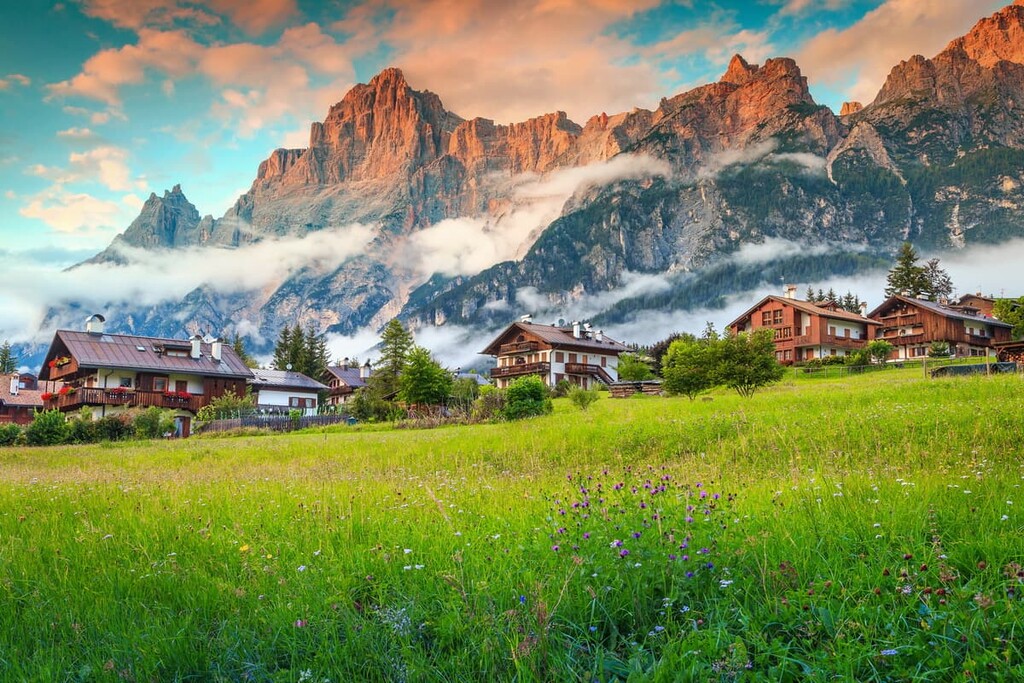
That is why the Dolomites are often called the “most beautiful mountains in the world” because of their unusual landscapes and the ability of the mineral dolomite to change color at sunset and sunrise in all the warm shades of the rainbow.

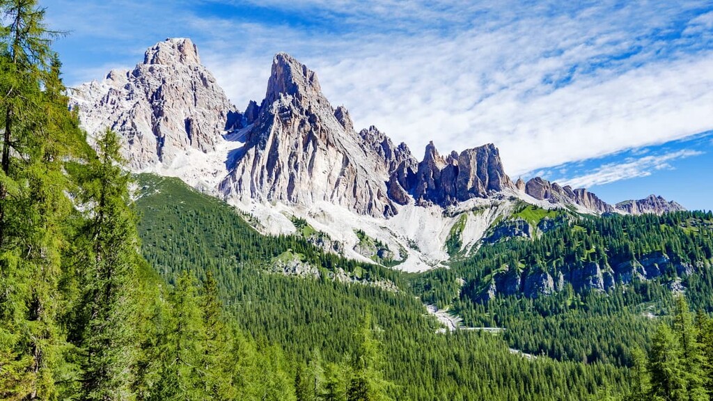
Because of its geological nature, the landscape of the Sorapiss group is similar to some other groups in the Dolomites. The Sorapiss is shaped in the same way as, for example, the Latemar Group—like the letter U or a horseshoe. Its open part facing the large Ansiei Valley to the northeast and its closed part facing Cortina d'Ampezzo in the valley of the same name.
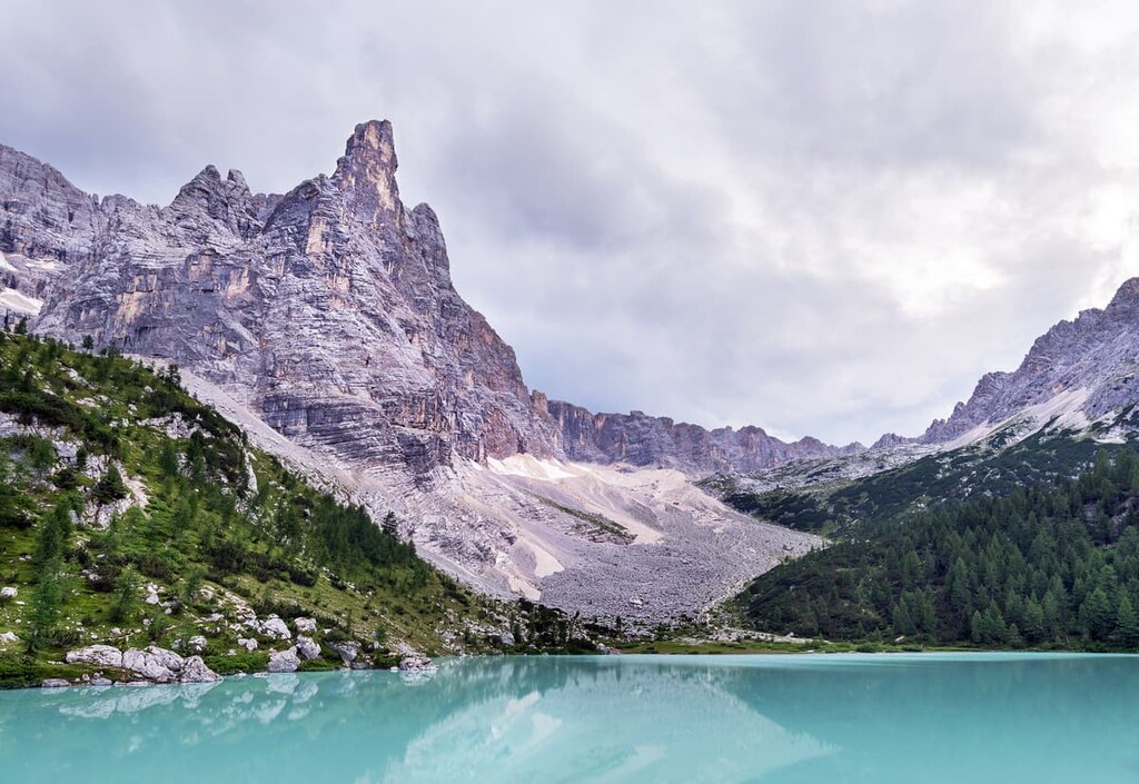
It is a monolithic group with the highest peak resembling a needle pointing into the sky—especially from the shores of Lake Sorapiss, set in a natural hollow surrounded by high hills and cliffs overgrown with sparse spruce forests.
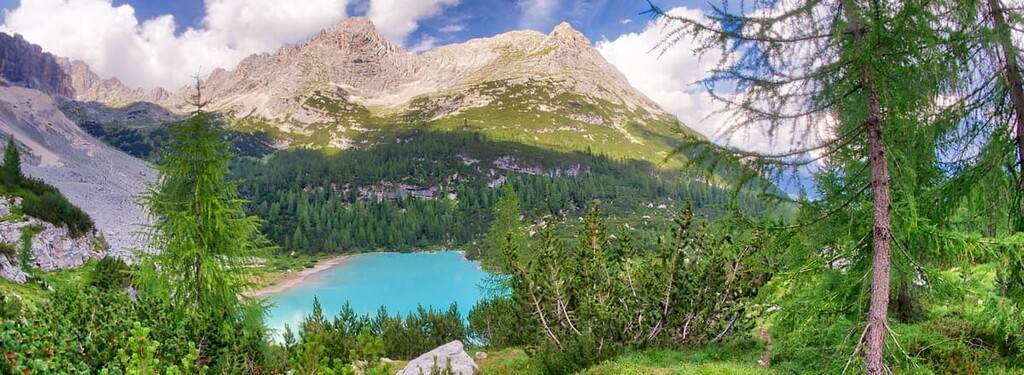
In fact, Sorapiss Lake and Misurina Lake are the two main features of the Sorapiss group’s landscape, so we’ll take a minute to focus on the two of them here:
Sorapiss Lake is a small glacial lake of 2.5 ha (6.2 acres) in area that’s located at an elevation of 1,923 m (6,309 ft). The peculiar color of its water is due to minerals and special natural chemical and bacteriological characteristics.
Thanks to the color and the magnificent scenery of the lake in general, it is one of the most famous lakes in the Dolomites on par with Carezza Lake and neighboring Misurina Lake, which are inferior in popularity only to Braies Lake, which is the most photographed on Instagram.

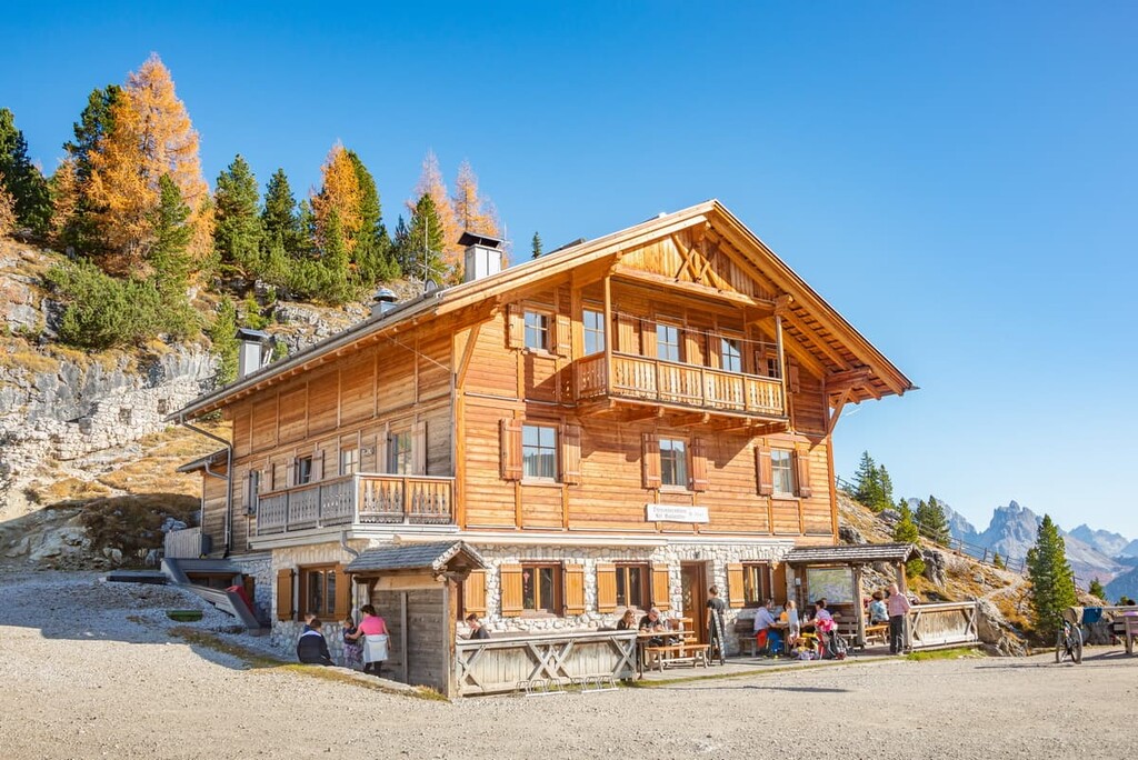
But, an important feature of Lake Sorapiss is that, unlike all the above-mentioned lakes, it cannot be reached by car, but only on foot. You can also spend a night on its shores in rifugio Alfonso Vandelli / Sorapisshütte to see how the top of Punta Sorapiss is painted in all the warm hues of light at sunset and sunrise.
It is not allowed to swim in the lake so as not to disturb its fragile ecosystem. It can also be dangerous: with a maximum depth of only about 2.6 m (8.5 ft), the bottom is not viewable. For both of these reasons, on August 1, 2019, the mayor of Cortina d'Ampezzo, Gianpietro Ghedina, issued a decree banning swimming in the Sorapiss Lake (with fines of up to €500).
In general, Lake Sorapiss is in danger even without the presence of people because of the retreating glacier that feeds the lake. In total, there are three small glaciers in the group, which have been melting a lot in recent years. Read and see more about this on the website of the Science Museum of Trento (in Italian).
The landscape of the Sorapiss Group is hard to imagine also without Misurina Lake, which lies to the southeast. I'm talking about another most postcard-like view in the Dolomites with a yellow "hotel" set against a background of mountains that are reflected in the waters of the lake, which you have probably already seen online.
The Sorapiss is located at a distance from the lake, so it is more visible than Cristallo, which starts right at the shores of the lake.
There is another common misconception on this view—the yellow building with green shutters is not a hotel but the Istituto Pio XII, a center for the treatment of childhood respiratory diseases such as asthma, the only one of its kind in Italy. It was built here because of a special mild microclimate which has formed, among other things, thanks to the lake.
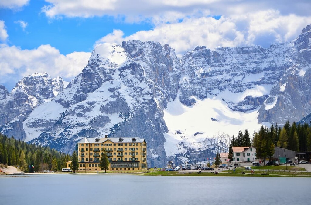
Those who have not been in the Dolomites often confuse this medical center with the Gran Hotel Misurina, which is built in a very similar architectural style. In fact, you can barely tell them apart, but it stands on the opposite side of the lake against the background of Tre Cime di Lavaredo, which, however, from this non-picture side is also difficult to recognize.
Actually, you can hike between two lakes and two mountain groups. Read about this route in the "Trails" section of this guide.
According to SOIUSA, the standard Italian classification system of the Eastern Alps, the Sorapiss Group belongs to the Dolomiti Ampezzane, which is part of the Dolomites.
According to the same classification system, the group consists of three parts: the central massif (Bastione del Sorapiss), which includes the peaks of Punta Sorapiss (3,205 m / 10,515 ft), Dito di Dio (2,603 m / 8,540 ft), Croda Marcora (3,154 m / 10,347 ft), and others, and the two long mountain ranges that depart from it: Contrafforte del Banco in the north and Diramazione della Punta Nera in the south.
Here are a few interesting facts about the three most important peaks in the group:
The first ascent of Punta Sorapiss, the highest peak of the group, was made by the world-famous Austrian alpinist Paul Grohmann in 1864.
From what we know from the historical climbing records, it took him around 8.5 hours to complete the climb. It was his fourth major peak in the Dolomites after Tofana di Mezzo, Antelao, and Punta Penia in Marmolada. Then, he continued to Tofana di Rozes, Piz Boè, Gran Pilastro, and Cristallo, among many other mountains.
Today there are still two major climbing routes to the Punta Sorapiss that were established by famous climbers of the previous centuries: Grohmann-Weg, which crosses the mountain’s west flank, and the Muller-Weg, which traverses the east glacier.
Another important fact from the history of mountaineering discoveries at the Sorapiss, is the VI-grade climb of Italians Emilio Comici and G. Fabian on the summit of the Punte Tre Sorelle (“The Point of Three Sisters”) on August 27, 1929.
The specified difficulty of climbing (grade) is determined by the International Union of Alpine Associations (UIAA) Grades for Rock Climbing.
If you are a true mountaineer and you love the Dolomites, you should also know that some of the mountaineering routes can disappear over time because of the collapse of the mountains that otherwise seem motionless and eternal—but they are not.

We have an example from Sorapiss: Just not far ago, on October 1, 2013, a landslide of about 300 m (984 ft) wide and 400 m (1,312 ft) high broke off from the Marcora peak, located about 500 m (1,640 ft) southwest of Punta Sorapiss.
So those going on another expedition to these and other mountains should not overlook the importance of checking the latest news from the region in the local groups and forums before heading outside.
The mountains of the Sorapiss group are known not only for their beautiful scenery but also for the hiking trails. Here you can hike from one to several days from a hike to the main attraction, Sorapiss Lake, to several via ferratas to the main peaks of the group. I'll briefly tell you about the main routes in the group:
The hike to Sorapiss Lake from Tre Croci Pass is the main trail in the group to the lake of the same name, about which you already know a lot.
Trail #215 begins at the nearby Tre Croci Pass and leads to the lake through alpine meadows, spruce forests, and cliffs. In particular, in the woods, you will pass through old Italian military fortifications, which helped defend the Tre Croci Pass from Austrians during World War I.

The lake can be accessed only on foot, which makes it less of a tourist attraction compared to Carezza and Misurina. Still, it is one of the most popular trails in this part of Dolomites, so you are unlikely to be alone—at least in the middle of the summer season.
The lake is home to the rifugio Vandelli, where you can spend the night and walk around the lake itself in the evening before going to bed or at dawn. It is possible to return by the same path or to take a parallel route, which I think is more interesting.
This is a hiking route between two famous lakes, without which it is difficult to imagine the landscape of the Sorapiss Group. It is not the most popular route, which may not be found in other sources, so here is an accurate description of it. You can orient yourself with the PeakVisor 3D Map, where all the main trails are marked.
From the Instituto Pio XII building at the Misurina Lake, follow the SP49 road directly to its junction with the larger SR48 road. Before it, turn off the road onto the hiking and biking road, which is marked by signs. Follow this side road in the further south direction until you come to a real trail that runs parallel to the car road for some time.

The trail then arrives at the location Valbona (there is also albergo Cristallo on the left side of the car road) and then turns and crosses the Rudavoi stream (at this point you are about halfway there) and then turns into Trail #217, which will lead you to Sorapiss Lake.
Somadida Forest is the largest spruce, fir and beech forest in the region and it grows at elevations of up to 1,400 m (4,593 ft). It is partially contained within the Somadida Nature Reserve (Riserva naturale Somadida) of the Cadoré region, which is located between the Sorapiss Group in the main summit area in its eastern ridge Croda del Banco and the Marmorole Group.
This is one of the 130 places under state protection and it is a completely non-touristy place, known mostly only to locals. It is worth stopping here before or after a trip to Lake Sorapiss to be alone with nature, including not only the flora but also the numerous wild animals.

On a walk in the woods, you may well see chamois, roe deer, deer, squirrels, dormice, foxes, stoats. The forests are also home to birds, including golden eagles, peregrine falcons, goshawks, buzzards, owls, capercaillie, and grouse.
Alta Via 3 is one of the eight longest alpine hiking trails in the Dolomites on par with Alta Via 1 and Alta Via 2, the latter of which is 100 km (62.1 mi) long and takes 8 days to complete.
If you start in the very beginning in Villabassa / Niederdorf in Pusterìa Valley in South Tyrol, you will arrive at the rifugio Alfonso Vandelli at the Sorapiss Lake from the rifugio Vallandro near the Monte Piano and Cristallo Group by day 2.
It also will take you the next day to cross the Sorapiss group via Forcella Ciadìn del Lòudo, (2,378 m / 7,801 ft)—the highest point of the whole Alta Via 3, Ra Zésta (La Cesta), Forcella Falòria (2,309 m / 7,575 ft), Monte Ciasadiò and rifugio Capanna Tondi until you reach the town of San Vito di Cadore in the Ampezzo Valley.
Another option is to hike the next route—Alta Via 4. It is 85 km (52.8 mi) long and takes 6 days to complete.
Similarly, if you start from the very beginning in San Candido in Val Pusteria in South Tyrol, you will arrive at the same rifugio Alfonso Vandelli at the Sorapiss Lake from the rifugio Città di Carpi in the Sexten / Sesto Dolomites by day 3.
It also will take you the next two days to cross the Sorapiss Group until you reach rifugio San Marco in the Marmolada group on the second day with one night in bivacco Emilio Comici just 317 m (1,040 ft) from the Croda del Banco summit on the way. However, for this route, you need via ferrata equipment.
Via ferrata Alfonso Vandelli is the main of the three via ferratas in the Sorapiss Group—a loop route through Lake Sorapiss and the same peak Croda del Banco on the east ridge along the impressive wall of Col del Fuoco.
The via ferrata is medium difficult, which in my opinion will suit the novice climbers to test themselves for the first time, and of course to admire the surrounding views of the lake from above, which we will not do from the shores of the lake.
The ferrata Alfonso Vandelli does not lead to the summit itself but runs through the bivacco Emilio Comici just 317 m (ft) from the summit. If you want, you can spend the night also.
Two other similar climbing routes in the Sorapiss are Via ferrata Francesco Berti, a circular route through the entire mountain group, and Via ferrata Carlo Minazio to the same peak Croda del Banco, but from the Samadida forest.
There is a ski resort called Faloria-Cristallo on the neighboring Mount Faloria and Cristallo Group—a part of the larger ski areas named Cortina d'Ampezzo Ski Resort, which is one of the 16 resorts of the Dolomiti Superski system.
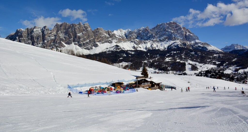
Here you can take one of the seven cable cards and different ski lifts leading to the slopes: five to Faloria and two to Cristallo Group. The ski runs start directly from Cortina d’Ampezzo, including the black (difficult) 1956 Winter Olympics giant slalom route called "Vitelli.”
On Faloria itself there are 6 red ski slopes (Faloria Normale, Tondi Normale, Vitelli Bassa, Slittone, Monti, and Freestyle Station), five black runs (Vitelli, Canalone Franchetti, Stratondi, Bigontina, and Scoiattolo), and one blue slope—Rio Gere—Pian de Ra Bigontina.
You can also ski in the area of Misurina Lake, where there are 2 red slopes (Col de Varda and Mazzorana), one black (La Pala), and one blue ski trail (Loita).
Check out the map of runs on the Dolomiti Superski website.
Check the Sorapiss ski resorts map on the larger Veneto and Italy ski maps in the World Mountain Lifts section of the site. It includes information about open ski lifts / slopes in the Sorapiss Group in real-time with opening dates and hours. There are also year-round cable cars, funiculars, cog railways, aerial tramways, and all other types of mountain lifts.
Before, and certainly, during your trip to the Dolomites, you can get more practical and inspiring information about Sorapiss Group and its famous lake, the Ampezzo Valley, and the Dolomites in general at the official information point located in the center of Cortina d'Ampezzo.
Info Point Cortina (Ufficio Informazioni Turistiche)
Corso Italia, 81, 32043 Cortina d'Ampezzo BL, Italy
General opening time: Monday—Sunday from 9:15 am to 12:45 pm and from 3 pm to 7 pm
+390436869086
There are four major mountain huts (rifugios) in Sorapiss, which are good for hut-to-hut hiking in the group.
When enjoying this type of hiking, one doesn’t need to carry a heavy backpack (30–40 liters is generally enough), a tent, or other equipment and supplies, such as food and fuel.
In fact, thanks to these huts, the Sorapiss (and the Dolomites in general) is a great place for practicing ultralight backpacking. That’s because the rifugios have most of what you need for the night, including provisions. You simply need to bring equipment for day hiking and enough snacks to tide you over during the day.
Rifugio Alfonso Vandelli (1,926 m / 6,318 ft)
43 beds in 6 rooms
Localita Sorapiss, 32043, Cortina d’Ampezzo, BL, Italy
+39043539015
Rifugio Capanna Tondi Famiglia Verzi (2,327 m / 7,634 ft)
8 beds in 4 rooms
Localita Alpe, Via Faloria, 1, 32043, Cortina d’Ampezzo, BL, Italy
+3904365775
Rifugio San Marco (1,823 m / 5,980 ft)
37 beds
Localita Col de chi da Os, 32046, San Vito di Cadore, BL, Italy
+3904369444
Rifugio Scotter-Palatini (1,580 m / 5,183 ft)
8 rooms with two, three, or four beds
Localita Ghiaioni Scotter 1, 32046, San Vito di Cadore, BL, Italy
+393290255704
There are also two bivouacs in Sorapiss for those who look for adventure: the bivacco Slataper (2,650 m / 8,694 ft), located on the western side of the Fond de Ruseco rock at the foot of Sorapiss peak, and the bivacco Emilio Comici (2,050 m / 6,725 ft), located on the Busa del Banco rock, surrounded by peaks that form the northeast extension of the Sorapiss Group.
In this case, you need to bring your own food and water, and cooking equipment, and better a sleeping bag with you. Usually there are blankets and pillows in the bivouacs managed by the Italian Alpine Club (Club Alpino Italiano, CAI), but they can be old and not very nice to use.
Cortina d’Ampezzo is the main settlement and year-round resort in this part of the Dolomites, which is the starting point for travels not only to the Sorapiss Group but also to Cristallo, Tofane, Nuvolau, and others.
Of course, thanks to its location, beautiful scenery and well-developed infrastructure, it is a very popular and therefore expensive resort, which became popular, thanks, among other things, to various celebrities who began to come here for holidays and skiing back in the eighteenth and nineteenth centuries. Here’s just one fact: only around 6,000 people live in Cortina, but in winter with the increase of tourists, the population also increases five times to 30,000 people.
If you don’t like the hustle and bustle and want to save some money, look to San Vito di Cadore, a less popular, yet still fantastic, place about 12 km (7.4 mi) to the south of Cortina in the Valle de Boite, next to the mountain Antelao at 1,011 m (3,316 ft) above sea level.
San Vito di Cadore is the westernmost of a series of towns in the neighboring region of Cadore. The first document tells about the town in 1203, however, the presence of a permanent settlement in the area is believed to date back to the year 1000.
Today it is still a small town with a population of 1,963 people (2021), many of whom speak Ladin. By the way, as elsewhere in the Dolomites, the name of the town in Ladin is different from its Italian, but very similar to it—San Viđo.
The main architectural and cultural attraction of the town is the Parish Church of San Vito (Chiesa dei Santi Vito, Modesto e Crescenzia), built in a typical Alpine style around the year 1200. The altarpiece inside the church is made by Francesco Vecellio, brother of the famous Italian painter Titian. You will surely not want to miss it.
The official tourist site: Dolomiti.org/en/cadore.


The highest peak in the Gruppo del Sorapiss is Punta Sorapiss, at 3,205 m.
The Gruppo del Sorapiss have 8 named peaks.


