
Explore worldwide mountains in real 3D
Outdoors maps should be in 3D. That’s the most intuitive way to embrace the mountains.
For centuries, people have been using maps to describe vast terrain. This is a convenient way to show geographical features in relation to each other: There’s a cafe on the opposite side of the road, there’s a house at the end of the street, there’s a sea in a distance. This approach, however, isn't ideal for navigating mountainous terrain.


Satellite 3D Maps available offline
Satellite 3D maps are available offline. We’ve spent months polishing and optimizing satellite imagery to make the maps nice and compact so that you can use them without Internet access, just like all other PeakVisor features. Don't worry, 3D maps don't take up too much space on your device. A lifetime hiking area as large as the Alps requires just 1GB on your phone. Smaller regions would require even less space.
Hiking Trails Navigation in 3D
Navigate worldwide hiking trails with PeakVisor 3D maps. Evaluate walking routes to map your next hike, plan adventures, and follow the path. Take your route-finding skills to the next level! Easily evaluate distance, elevation gain, complexity, and time required for any hike.
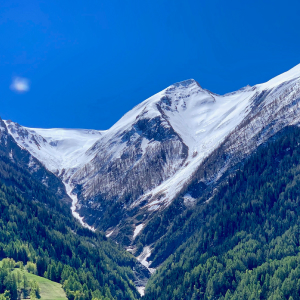
Topographic 3D Maps
Instantly grasp any mountainous terrain with all of the capabilities of PeakVisor 3D maps. Deep gorges and towering peaks appear tangible and realistic. A set of useful geographic features allow you easily orient yourself in an unknown space. Parking lots, viewpoints, mountain huts, lakes, rivers, and villages are the most important navigation orienteers and are mapped worldwide. If existing features aren’t enough, just add any points of interest on the map and keep track of them in real 3D.