
Scan the QR code and open PeakVisor on your phone
Alberni-Clayoquot Regional District is home to 131 named mountains. The highest is Mount Celeste at 2,045 m.
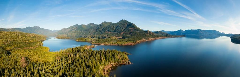
The Alberni-Clayoquot Regional District is an administrative region that’s located on the western coast of Vancouver Island in the province of British Columbia in Canada. The district stretches from its north boundary near Nitinat Lake to its southern border near Nootka Sound and has 131 named mountains. The tallest mountain in the region is Mount Celeste, with an elevation of 2,045 m (6,709 ft).
Located on the west coast of Vancouver Island, British Columbia, the Alberni-Clayoquot Regional District is an administrative region that has 124 named mountains and a particularly rugged coastline.
The tallest mountain in the region is Mount Celeste, which stands 2,045 m (6,709 ft) tall and has 586 m (1,923 ft) of prominence. Meanwhile, Klitsa Mountain is the most prominent peak in the regional district, with an elevation of 1,639 m (5,377 ft) and a prominence of 1,395 m (3,100 ft).
Alberni-Clayoquot Regional District extends as far south as the famous Nootka Sound, where Captain James Cook first made landfall on Vancouver Island. Nitinat Lake defines the southern end of the region, where it borders the Capital Regional District.
The Comox Valley Regional District, Cowichan Valley Regional District, and the Regional District of Nanaimo are all adjacent to the Alberni-Clayoquot Regional District, bordering it on the eastern side of Vancouver Island. Additionally, Strathcona Regional District is located to the north of Alberni-Clayoquot and covers the north end of Vancouver Island.
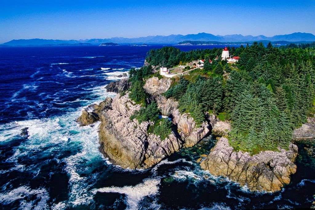
Port Alberni, Tofino, and Ucluelet are the major communities in the region. All three of these communities are located on tidal waters; however, Port Alberni is in the middle of the island, at the end of the Alberni Inlet. Tofino and Ucluelet are located along the rugged western coast of Vancouver Island and are subjected to intense winter storms.
There are many provincial and national parks in the Alberni-Clayoquot Regional District. The following are some of the major parks found in the region:

The main access to the Alberni-Clayoquot Regional District is the trans-island Highway 4 from Parksville, near the city of Nanaimo. The region spans a wide area from Nitinat Lake to Nootka Sound and has a population that is just over 30,000 people, with over half of the region’s residents living in Port Alberni.
The major geologic formation of the Alberni-Clayoquot Regional District is the Vancouver Island Ranges; however, the Pacific Rim Terrane is also found in the district. The Pelham Range, Somerset Range, and the Pierce Range are the main subranges of the Vancouver Island Ranges found in the district.
The Vancouver Island Ranges are a main component of the insular belt, which is the westernmost major tectonic subdivision of the Canadian Cordillera. The Canadian Cordillera includes the Rocky Mountains in Alberta and the east of British Columbia, the Columbia Mountains, and the Coast Mountains.
The insular belt of terranes and its mountains make up Vancouver Island, the Queen Charlotte Islands, part of southeastern Alaska, and a strip of the mainland coast. The rocks found in the region are mainly igneous in origin from the middle Paleozoic and Jurassic.
These rocks are underlain by a gneiss-migmatite terrane, and they are overlain with Permian-Pennsylvanian and Cretaceous clastic sediments. There is a thick shield of Triassic basalt overlain with clastic sediments that separate the above terranes.
The Pacific Rim Terrane collided with and accreted to the west coast of Vancouver Island between 42 and 55 million years ago. It now makes up the bulk of the island’s coastline, which includes the Pacific Rim National Park Reserve. This land was made from deformed Jurassic and Cretaceous trench deposits with an outer layer of oceanic basalt and crystalline rocks.
During the Pleistocene, glaciers and ice sheets covered the island in at least four separate events over 2 million years. The Fraser Glaciation, which occurred between 29,000 to 15,000 years ago, covered Vancouver Island with over a kilometer of ice and depressed the island 300 m (984 ft) due to the weight of the ice.
Many glaciers formed in the mountains in the middle of the island, in what is now Strathcona Provincial Park, and stretched out to the west coast. As the glaciers flowed down the mountains, they created long U-shaped valleys that stretched from the mountains to the west coast of the island. As the glaciers melted and the sea level rose, the long valleys were filled with water and created the steep sided fjords of the west coast of Vancouver Island.
The primary ecologies in the Alberni-Clayoquot Regional District are the Coastal Western Hemlock zone, which covers the majority of the region, and the Mountain Hemlock zone, which is found in place of an alpine zone at the highest elevations in the region. There is a small amount of alpine ecology in the region, most of which is located in Strathcona Provincial Park.

The alpine ecology in the region is located at the peaks of Mariner Mountain, Moyeha Mountain, Mount Tom Taylor, Nine Peaks, Big Interior Mountain, and Mount Rosseau. The aforementioned mountains are part of Strathcona Provincial Park, and the peaks are rocky with extensive communities of mountain heather.
The upper slopes in the range (below the alpine region and at the peaks of the rest of the mountains in the district) are covered with a parkland-like ecosystem of sedge and heather meadows dotted with stands of interspersed trees. The trees are primarily mountain hemlock and amabilis fir with varying amounts of yellow cedar.
Here, forests of mountain hemlock transition into the primary forests of the region, which are filled with western hemlock, red cedar, and Douglas fir. The forests along the coast are dominated by Sitka spruce, which have adapted to live in an area that’s sprayed regularly with sea water. Other trees that are found in the Coastal Western Hemlock forests include alder and bigleaf maple.
The Coastal Western Hemlock zone of Alberni-Clayoquot Regional District has among the greatest diversity and abundance of wildlife habitat in British Columbia. The coastal margins of the region provide habitat for colony-nesting birds, such as tufted puffins, ancient murrelets, Cassin’s auklets, and rhinoceros auklets.
Old-growth forests in the region provide important winter shelter for black-tailed deer while the steep, cold mountain streams are used by the Pacific giant salamander and the tailed frog. Marbled murrelets and snowy owls also inhabit the region’s old growth forests.
There is evidence that the Alberni-Clayoquot Regional District has been inhabited for at least 4,000 years. First Nations traditionally hunted grey and humpback whales in the waters around the region because they were easier to catch; however, hunting the orca was frequently viewed as a sign of bravery and a way to move up in social standing in many cultures.
Social standing and class became very important to the First Nations of the region and the abundance of resources allowed time and energy to be spent developing distinct social classes. Rights to property and opportunity were given in the region based on one’s social status. This includes the right to attend the whale hunt as well as preferential access to the distribution of resources.

While lower-class citizens required consent of the chief to hunt and collect resources from their territory, the chief held status and authority only by ensuring their nation was provided for. The potlatch is a traditional ceremony practiced among many First Nations in the region where the host gives generous gifts to the guests to raise their own status. The more a person could give, the more important that person was.
Potlatches were a way of redistributing wealth, and of maintaining and achieving social status. The ceremonies were also used to cement alliances and marriages, as well as to commemorate other important events.
The oral history of the Nuu-chah-nulth refers to a great flood that occurred in the region. Indeed, the Nuu-chah-nulth consider themselves to be descendants of a group of people that were able to save themselves by tying their canoes to the top of a mountain as the waters rose.
After the flood, the Ditidaht were among the most dominant groups in the region. The Nuu-chah-nulth separated from the Ditidaht at some point after the flood and named themselves for the sea foam that they encountered in a river.
Nuu-chah-nulth includes members of 14 different groups, 9 of which currently reside in the Alberni-Clayoquot Regional District. The Nuu-chah-nulth were previously called the Nootka, after their first encounters with Europeans in 1778.
In 1778, Captain James Cook encountered residents at the village of Yuquot on the west coast of Vancouver Island. Villagers directed the captain to “come around” (In Nuu-chah-nulth, nuutka means to “circle around”) and the name was applied to the people and the sound, Nootka Sound, which Captain Cook had entered. The Nuu-chah-nulth were among the first Pacific people north of what is now California to encounter Europeans.
At the end of the eighteenth century, the British and the Spanish disagreed with each other over who had rights to the island and its marine resources. At the time, marine furs were very popular and there was great profit to be made for the countries that had access to these furs. Spain claimed sovereignty over the Pacific Northwest from a papal declaration during the fifteenth century.
The Nootka Crisis, which started in 1790 and nearly brought Britain and Spain to war, was settled during the Nootka Convention where Spain agreed to abandon their exclusive claim to the Pacific Northwest. Maquinna, Chief of the Mowachaht, helped settle the dispute which was attended by George Vancouver for the British and Juan Francisco de la Bodega y Quadra for the Spanish.
An interesting historical note of the time describes how in 1803, Maquinna led an attack on the American trading ship Boston, killing the captain and all but two of the crew. The two crew members were kept as slaves for several years before a rival group helped to free them.
By 1830, barely 50 years since the first European contact, more that 90 percent of the Nuu-chah-nulth had died from malaria and smallpox. An estimate of the nation’s population in the early twentieth century was only 3,500 people.
Trading posts were built in the area to facilitate the harvesting and trading of furs for the Hudson’s Bay Company. To facilitate settlement and the fur trade, Adam Horne was tasked with finding an overland route to the west coast, and in 1856 he “discovered” a trail that First Nations had been using for generations that connected Qualicum and the Alberni Valley.
The massive trees drew investors who built sawmills in the late nineteenth century and there were several gold discoveries between 1862 and the 1960s. By 1912, the E&N Railway had finally arrived in Port Alberni, allowing for the community to grow, and be incorporated. The major industries of the region are mining, fishing, and forestry. Today, there are some incredible tourist areas as well as marine research areas in the region.
While the Alberni-Clayoquot Regional District is remote, one of the most famous Canadian hiking trails, as well as other amazing areas, are found in the region. The following are some of the spectacular trails and attractions in the Alberni-Clayoquot Regional District:
The West Coast Trail of Pacific Rim National Park Reserve is one of the most famous and iconic trails in Canada. In the 1800s, over 250 sailing vessels were sunk due to the severe storms on the western coast and the area became known as the “Graveyard of the Pacific.” Lighthouses and a telegraph line were installed to help prevent future tragedies from occurring.
In 1906, the passenger steamer Valencia sank, taking with her 164 passengers and crew. This incident was the catalyst to upgrade the original West Coast Telegraph trail to become the “Lifesaving Trail” that shipwrecked crew and passengers could follow to safety if wrecked on the west coast. Many lives were saved because of this trail.
With the development of more sophisticated navigation equipment, trail maintenance was discontinued in the 1940s. However, in the 1970s, Parks Canada undertook a major redevelopment of the “Lifesaving Trail” to create one of the most challenging and best-known hikes of Canada and North America,
The 75 km (45 mi) trek along the rugged west coast of Vancouver Island has around 70 ladders, 4 cable cars, and 130 bridges to cross. The trail starts at Bamfield and ends in Port Renfrew and is usually hiked over 5 to 7 days. Reservations and permits are required, and the trail is open from May 1 until September 30.
Located between Tofino and Ucluelet, Long Beach is the largest and longest beach in Pacific Rim National Park Reserve. The beach features rocky islands that are accessible during low tide, incredible storm watching, a vast sandy beach, and consistent waves.

The beach was established as one of the earliest and most popular surfing destinations in British Columbia. The consistent surf which is exposed to the open Pacific Ocean makes for great waves. However, storm surges and rip tides are also present along the beach and pose threats to visitors.
Visiting Maquinna Marine Provincial Park on the west coast of Vancouver Island is an opportunity to get off the beaten path and explore one of the finest hot springs in Canada. The park is only accessible by boat and float plane and there is a dock to receive visitors. From the dock, there is a short 2 km (1.2 mi) hike along a boardwalk to Hot Springs Cove.
The hot springs are situated in some of the most scenic and natural areas of British Columbia, and they will not disappoint. The geothermal hot springs cascade down a waterfall and pass through half a dozen rocky pools. With an average temperature of 50 degrees C (122 degrees F), the water gradually cools as it runs from pool to pool as it is exposed to the ocean swells.
The west coast of Vancouver Island is remote and has a rugged natural beauty that is fantastic to see and experience. There are massive old growth forests, incredible hiking trails, and amazing scenery and landscapes. The following are some of the main destinations in the Alberni-Clayoquot Regional District.
Port Alberni is located at the head of the Alberni Inlet, on the west coast of Vancouver Island, British Columbia. The town is named after Don Pedro de Alberni, who commanded Fort San Miguel at Nootka Sound from 1790 to 1792. The area is in the territory of the Nuu-chah-nulth Tribal Council and many of the area names are Nuu-chah-nulth in origin.

The first sawmill was built in 1860 and milling and forestry became the major employers of the region. While milling and logging are still integral to the local and regional economy, Port Alberni is shifting their environmental focus to draw in and capitalize on tourism to the area.
Port Alberni is a good jumping off point for many outdoor activities. Marine and freshwater fishing, hiking, kayaking, and mountain biking are all activities that can be easily enjoyed from the community. There are several hiking trails in Port Alberni and over a hundred in the surrounding valley and mountains.
Some of the popular hikes in the area are the Horne Lake Trail, Log Train Trail, and the Inlet Trail. Mount Arrowsmith is nearby if you want to hike the Saddle Trail, or you can climb to the summit. Port Alberni is the gateway to the rugged and wild west coast of Vancouver Island and there are many activities to enjoy.
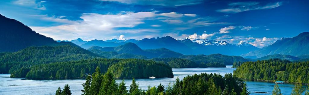
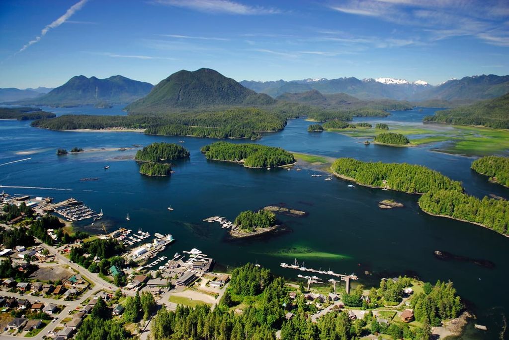
Located on the west coast of Vancouver Island at the end of Highway 4, at the edge of Clayoquot Sound, Tofino is a year-round tourist destination; however, the population swells significantly in the summer. The area attracts surfers, campers, backpackers, hikers, mountain bikers, whale watchers, bird watchers, and anybody that wants to enjoy nature.
Long Beach, in Pacific Rim National Park Reserve, is near Tofino and is especially popular with surfers. While the summer is popular because the weather is warm, the winter season gives an incredible display of the ocean’s power during the winter storms. Massive waves can be seen rising above and smashing into the west coast near Tofino.
Located on the Ucluelet Peninsula on the west coast of Vancouver Island, Ucluelet, like Tofino, has become a year-round tourist destination. Long Beach and the Broken Group Islands of the Pacific Rim National Park Reserve are located on either side of the community, in addition to other trails and attractions.
Some of the activities to do while in Ucluelet are surfing, fishing, camping, hiking, kayaking, swimming, and beach combing. The winter storms from November to March are a sight to behold and it’s worth making a visit to the area in the winter.
Long Beach is popular for surfing and other beach activities. Other places to surf include along Florencia Bay and Wickaninnish Beach. If you’d prefer hiking, the Wild Pacific Trail is a regional trail that begins near the mouth of the Ucluelet Inlet and travels along the Pacific coastline through Big Beach Park and ends just outside Ucluelet. The path is well maintained and there are stunning coastal views along the way.


Yes. Alberni-Clayoquot Regional District has 131 named mountains. The highest is Mount Celeste at 2,045 m.
The highest mountain in Alberni-Clayoquot Regional District is Mount Celeste, at 2,045 m.
Alberni-Clayoquot Regional District has 131 named mountains.


