
Scan the QR code and open PeakVisor on your phone
The west coast of Vancouver Island in British Columbia, Canada has long been known for its beautiful scenery, rugged coastline, and dense forests. The West Coast Trail Unit of Pacific Rim National Park Reserve encompasses the region’s legendary 75 km (45 mi) trail that has been used as an Indigenous trade route and a lifesaving trail for sailors for hundreds of years. There are 5 named peaks in the unit, the highest and most prominent of which is Hobbiton Ridge (799 m/2,621 ft).
The West Coast Trail Unit of the Pacific Rim National Park Reserve is one of three distinct units of the reserve.
Alongside the other units in the park reserve, the aptly named West Coast Trail Unit is located on the west coast of Vancouver Island in British Columbia, Canada. The units of the National Park Reserve are Long Beach, Broken Group Islands, and West Coast Trail.
The Long Beach Unit is located near the town of Tofino and is the northernmost of the three units. It features the famous Long Beach, which is known for fierce winter storms and incredible waves that provide for excellent year-round surfing conditions.
Meanwhile, the Broken Group Islands are located in the Barkley Sound between Ucluelet and Bamfield. Kayaking is the best way to explore the islands and to enjoy their incredible beauty.
Finally, the West Coast Trail Unit is the southernmost of the units and it is located along the west coast of Vancouver Island. The northern access point for the unit is at Pachena Bay, which is located near Bamfield. Additionally, the southern terminus of the unit is situated at Gordon River near Port Renfrew. Nitinat Narrows is an accessible location in the middle of the park and trail.
The West Coast Trail Unit of the national park reserve contains five peaks that you may glimpse from the trail. The tallest point in the unit is Hobiton Ridge, which stands at 799 m (2651 ft) above sea level. The other highpoints in the park reserve are Pandora Peak, Nitinat Hill, Nitinat Cone, and the Limestone Bluffs. Nitinat Cone is a remnant of the region’s volcanic past.

More than 200 million years ago, the ancient continental margin of North America was roughly located along the current border between Alberta and British Columbia. Most of British Columbia was created or added in the past 200 million years through volcanic activity in-situ or as exotic volcanic island chains in the Pacific.
About 195 million years ago, the Farallon Plate broke, creating the Intermontane and the Insular plates. It then began to subduct beneath the continent for the first time. The Intermontane Plate subducted beneath the continent and created the Omineca Volcanic Belt along the coast as well as the beginning of the Columbia Mountains.
Around the same time, the Insular Plate subducted beneath the western edge of the Intermontane Plate, which created an island arc called the Intermontane Islands. In time, the Intermontane Islands would accrete to the western edge of the continent to become the foundation of the Thompson, Fraser, and Nechako Plateaus.
The accretion of the Alexander and Wrangellia Terrane followed the accretion of the Intermontane Terrane. The collision of these terranes closed the Omineca volcanic belt and opened another zone of volcanic activity along the coast. The Alexander Terrane composes areas along the central coast of British Columbia and the panhandle of Alaska.
The Wrangellia Terrane consists of the southern Canadian Coast Mountains and the Vancouver Island Ranges. The collision of Wrangellia with the west coast coincided with the Laramide orogeny, which was the mountain building event that was primarily responsible for the formation of the Rocky Mountains.
While most of Vancouver Island is composed of the Wrangellia Terrane, the Pacific Rim National Park Reserve is situated upon the unique Pacific Rim Terrane. About 55 million years ago, the Pacific Rim Terrane was accreted to the edge of the island, compressing the continental margin.
The compression caused by the Pacific Rim Terrane Accretion caused the uplift of the Vancouver Island Ranges and many of the islands in the Georgia Strait, such as the Discovery Islands.
About 42 million years ago, the Crescent Terrane accreted to the southern end of Vancouver Island. The accretion of the Crescent Terrane lifted the Saanich Peninsula above sea level, while also folding sediments in the Georgia Strait to create the Gulf Islands.
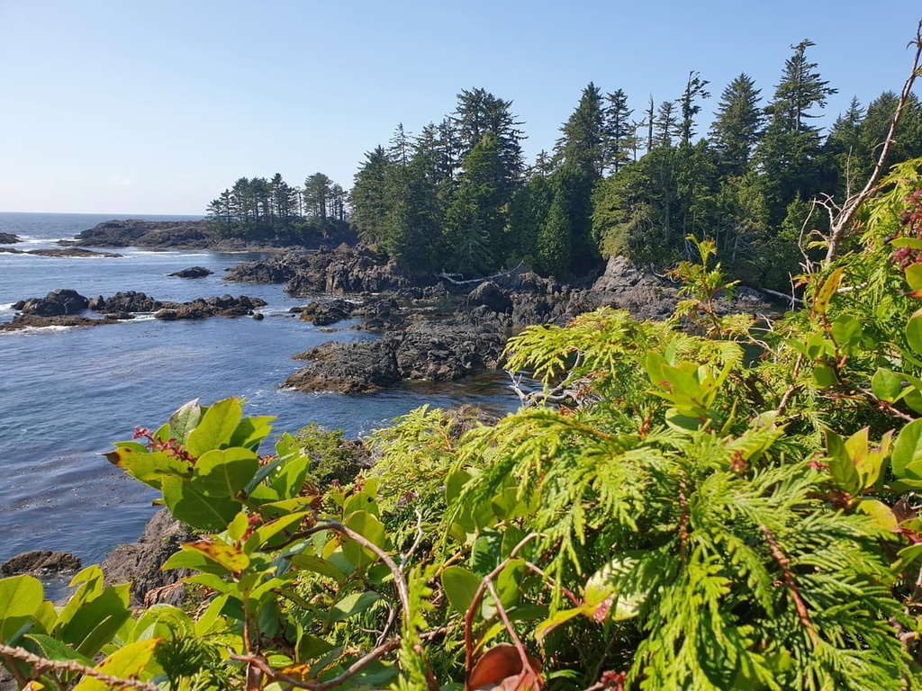
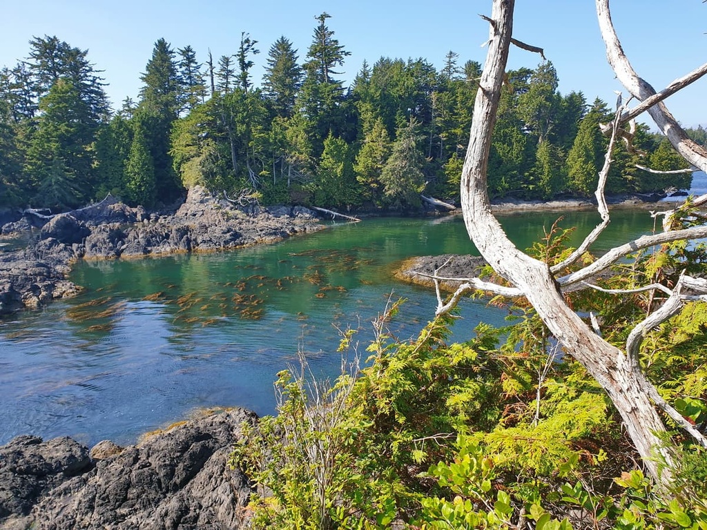
The West Coast Trail follows the narrow band of the Pacific Rim Terrane along the west coast of Vancouver Island. The terrane is composed of metamorphosed sedimentary and volcanic rocks from the Triassic and Jurassic.
The terrane subducted beneath the Wrangellia terrane, leaving only small remnants visible on the surface. This terrane is found only across Pacific Rim National Park Reserve, from Long Beach, through the Broken Group Islands, and along the coastline that’s traversed by the West Coast Trail.

The Coastal Western Hemlock ecosystem is the dominant ecosystem found along the West Coast Trail; however, the small size of the park allows for a more in-depth look at the different ecosystems along the trail.
In fact, there are at least six distinct ecologies that are found along the coastal trail. These are the Near Shore Ocean, Intertidal, Sand Dunes, Shorepine Bog, Spruce Fringe, and Cedar Hemlock ecosystems.
As a large part of the trail is located along the beach, visitors can enjoy many opportunities to admire the ocean. Visitors to the trail may be fortunate to see some of the region’s abundant sea life, which includes salmon, dolphins, seals, sea lions, and whales. Having been hunted to near extinction, sea otters are still rare along the West Coast Trail; however, they are making a comeback.
The intertidal area along the trail is in constant transition between high and low tides. It’s where you may discover sea urchins or other incredible animals in the tidal pools. Hungry birds visit the low tide beaches, such as the western sandpiper on its Arctic migration, and perhaps you’ll even see a Vancouver Island wolf in the distance.
The trail’s sand dunes are a particularly fascinating place that’s situated between the ocean and the forest. The shore grasses on the dunes are important for keeping the sand in place and preventing it from blowing away. If you are fortunate during your trip, you may find one of the pink sand-verbena plants. There were only two known individuals left when Parks Canada intervened and has since brought the species back from the point of extinction.
Beyond the sand dunes, you may also see the shorepine bog or a spruce fringe forest. Poor drainage creates the bogs, where sphagnum moss releases acids that prevent bacteria growth. Without bacteria, nutrients from dead plants are not recycled back into the ecosystem, thereby minimizing plant growth. The stunted shorepine trees are one of the many stunted plants found in the bogs.

As the trail is located along the coast, the winds blow salt spray toward the forests, making an inhospitable environment for many species. Salal and Sitka spruce are two of the few species that have adapted to survive in these salty conditions. These trees form a krummholz wall, often looking like sculpted bonsai trees, protecting the trees of the inner forest.
The interior forest is the temperate rainforest that the west coast of Vancouver Island is famous for. There are massive western red cedar and western hemlock trees found in the forest. Here, thick moss covers most of the tree trunks and ferns grow in abundance. Some areas may also have giant Douglas firs, big leaf maples, and alders.
There are bears and cougars in the park; however, you’re not likely to see them. That said, visitors are likely to see eagles and many other birds, and perhaps some of the black-tailed deer that inhabit Vancouver Island.
Before the arrival of foreign sailing ships, the west coast was and continues to be the home of the Huu-ay-aht, Ditidaht, and Pacheedaht First Nations. Their villages and camps dotted the shores for thousands of years and they traveled along the west coast by foot and canoe for hunting and trading purposes.
By the eighteenth century, the region’s abundance of fur-bearing marine animals drew in ships from across the world. British, Spanish, and even Russian ships were common along the west coast of Vancouver Island during this time, as they came to harvest the animals from the sea.

However, the west coast was and is a rugged and dangerous coastline. As a result, when the number of ships sailing the Juan de Fuca Strait increased, so did the number of shipwrecks. In a short time, the coast became the “graveyard of the Pacific.”
To aid sailors as they navigated these dangerous waters, the government of Canada built the Beale Lighthouse in 1873 and the original Carmanah Lighthouse in 1891. By the time the Carmanah Lighthouse was constructed, a telegraph line had been run along the coast, through the territory of the Huu-ay-aht, Ditidaht, and Pacheedaht to connect the two lighthouses and Victoria.
While the lighthouses helped, after more than 125 lives were lost in 1906 when the steamship SS Valencia went down, the public demanded that more be done to help seafarers and their rescuers. The government responded by constructing the Pachena Lighthouse in 1908, while also establishing life saving stations at Bamfield and Clo-oose.
Additionally, the telegraph route was upgraded with six shelters that were stocked with provisions on what became known as the Dominion Life Saving Trail. As technology improved, the lifesaving measures grew into obsolescence and were abandoned.
When Pacific Rim National Park Reserve was established in 1973, the old Dominion Life Saving Trail was rebuilt as the recreational West Coast Trail.
The major attraction and trail of the West Coast Trail Unit of the Pacific Rim National Park Reserve is the opportunity to hike the world-famous West Coast Trail. While officially listed as 75 km (45 mi) long, due to trail options and reconstruction, the actual trail is an estimated 80 km (50 mi) to 92 km (57 mi) long.
The trail runs roughly between Bamfield in the north and Port Renfrew in the south. It can be traveled in either direction, and most backpackers take about 7 days to complete the trail. Day hiking is permitted on the trails and there is the option of starting or ending at the midpoint of Nitinaht Narrows.
Nowadays, the West Coast Trail features a path that takes you along sandy beaches and rocky shores and through dense cedar and hemlock forests. There are many river crossings where hikes must wade, cross a log, or use a cable car. Additionally, the trail has many boardwalks and ladders that are over 10 m (30 ft) tall.
However, the West Coast Trail hike is not for new hikers, and there are many other options if you aren’t ready for such a strenuous and remote trek.
Some of the other hiking options to prepare yourself for the West Coast Trail are the Juan de Fuca Provincial Park and Marine Trail, the hikes in Strathcona Provincial Park, the Wild Pacific Trail in Ucluelet, or the Wild Side Trail on Flores Island. Additional training hikes and excursions can happen in Banff or Jasper National Park.
While on the trail, some of the sights to see are the Pachena and Carmanah lighthouses. There are many cultural sites along the trail pertaining to the First Nations who have lived along the coast for thousands of years. There are also over 20 shipwrecks that can be seen from the beach and the trail, including that of the Valencia, which spurred the construction of the Dominion Life Saving Trail in the early 1900s.

The West Coast Trail runs between Bamfield and Port Renfrew on Vancouver Island. The following are some of the few communities where you may want to start your adventures in the national park reserve.
Located along the south side of Barkley Sound on the west coast of Vancouver Island, Bamfield is the northern terminus for the famous West Coast Trail. The small community is home to the Bamfield Marine Sciences Centre, which offers educational tours and university credit courses.

Additionally, Bamfield is the starting point for adventures in the Broken Group Islands thanks to its many ferry and water taxi services. It can also serve as a launching point for a sea-kayak adventure. Their community boasts spectacular scenery, fresh seafood, and lots of opportunity for adventure.
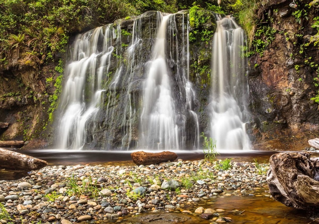
Located on the southern shore of Port San Juan, the community of Port Renfrew is the closest community to the southern terminus of the West Coast Trail. The community is also popular for the beaches that surround it, such as Botanical Beach, with its incredible tidal pools and interesting rock formations, and Sombrio Beach, with its sandy beaches, great surf, and hidden waterfall.
From Port Renfrew, there are marine and wilderness excursions that you can head out on that feature fishing, hunting, whale watching, and hiking. Also accessible from Port Renfrew are several hikes on the south side of Carmanah Walbran Provincial Park. From the logging roads you can access the Harriet Nahanee Memorial Trail, Anderson Lake Trail, and the Castle Grove and Castle Giant Trail, and see the ancient forest of the Walbran Valley.

Port Alberni is located at the head of the Alberni Inlet on the west coast of Vancouver Island. The town is named after Don Pedro de Alberni, who commanded Fort San Miguel at Nootka Sound from 1790 to 1792.
Port Alberni is a good jumping off point for many outdoor activities. Marine and freshwater fishing, hiking, kayaking, and mountain biking are all activities that can be easily enjoyed from the community. There are several hiking trails in Port Alberni and over a hundred trails in the surrounding valley and mountains.
Some of the most popular hikes in the area are the Horne Lake Trail, Log Train Trail, and the Inlet Trail. Mount Arrowsmith is also located nearby if you want to hike the Saddle Trail or climb to the summit. Port Alberni is the gateway to the rugged and wild west coast of Vancouver Island and there are many activities to enjoy.

Victoria is the capital of British Columbia and is located at the south end of Vancouver Island on the Saanich Peninsula. If arriving by plane to hike the West Coast Trail, you’ll likely travel through the Victoria International Airport.
The area boasts a long and storied history of the Coast Salish, who have traditionally inhabited this land since time immemorial, as well as a long history of British colonization. Victoria is known as the “Garden City” and the historic downtown is maintained in a way that complements the many historic buildings that are still present in the city today.
In Victoria, some great hikes to prepare yourself for the West Coast Trail are found in Mount Work Regional Park, Gowlland Tod Provincial Park, and Goldstream Provincial Park, all of which surround the Saanich Inlet and have beautiful trails with excellent viewpoints that are worth checking out.


