
Scan the QR code and open PeakVisor on your phone
Gowlland Tod Provincial Park is located on the east side of the Saanich Inlet in the Capital Regional District of Vancouver Island in British Columbia, Canada. The park encompasses 1,219 ha (3,012 acres) of land and has four peaks, the tallest of which is Jocelyn Hill at 434 m (1,424 ft) of elevation and 216 m (709 ft) of prominence. The other peaks in the park are Holmes Peak, Partridge Hills, and Cole Hill.
Located on the south end of Vancouver Island, British Columbia, Gowlland Tod Provincial Park covers 1,219 ha (3,012 acres) of land in the Gowlland Range along the eastern shore of the Saanich Inlet. The park overlooks the Finlayson Arm of the Saanich Inlet and extends from Goldstream Bay to Brentwood Bay.
There are four peaks in Gowlland Tod Provincial Park, of which Jocelyn Hill is the tallest and the most prominent with 434 m (1,424 ft) of elevation and 216 m (709 ft) of prominence. Partridge Hills and Cole Hill are located on the north end of the park overlooking Willis Point and Brentwood Bay, while Jocelyn Hill and Holmes Peak overlook the Finlayson arm of the Saanich Peninsula.
The trails of Gowlland Tod Provincial Park are part of a regional trail system that connects to several other provincial and regional parks. Trails connect to One Tree Hill Regional Park and Mount Work Regional Park. Goldstream Provincial Park and Thetis Lake Regional Park are also located just south of Gowlland Tod Provincial Park.
The oldest rocks on Vancouver Island started out as lava flowing from undersea volcanoes 380 million years ago. For the next 100 million years, marine sediment slowly accumulated on top of the lava.
Then, approximately 230 million years ago, the Earth’s crust opened and massive amounts of lava poured out creating a 6 km (3.6 mi) thick layer of basalt. This basalt now forms most of the rocks of Vancouver Island. About 100 million years ago, this land mass, called Wrangellia, collided with North America. This caused some of the land to buckle and form mountains while other parts crumbled and eroded.
The Gowlland Range, which is partly contained within Gowlland Tod Provincial Park, formed as part of the mountains of the Vancouver Island Ranges. The Vancouver Island Ranges, Haida Gwaii, and the Alaskan panhandle are all made up of rock from the Wrangellia terrane.

By about 38 million years ago, the basic geologic features of Vancouver Island had formed, and were now fully subjected to the sculpting powers of erosion. Massive topographical changes occurred during the Pleistocene where at least four glacial maximums, and possibly as many as 20, scoured the island mountains and the area around Gowlland Provincial Park.
The Findlayson Arm and the Saanich Inlet were the result of glaciers forming in the mountains and eroding large U-shaped valleys as they moved towards the coast. The last glaciers melted from southern Vancouver Island about 9,000 years ago.
As the ice sheet and glaciers melted away 9,000 years ago, Vancouver Island gained elevation for the next 1,500 years as it rebounded from the depressing weight of the ice sheet. As worldwide temperatures increased, melting glaciers worldwide, the sea level rose and submerged some of the coastline again, filling areas such as the Saanich Inlet.
The collision of tectonic plates and the subsequent formation of mountains is still actively occurring near and across Vancouver Island. To the west of Vancouver Island, the Juan de Fuca plate is still actively subducting beneath the North American Plate. The subduction process is rarely smooth and it normally happens in bursts, causing earthquakes and tremors of varying magnitude across the island and mainland Canada.
Furthermore, multiple fault lines cross Vancouver Island. In particular, the Malahat Fault runs alongside Gowlland Tod Provincial Park. The Malahat Fault runs from Goldstream along the Findlayson Arm through to Sidney. When the fault slips, it may cause cracking of the surface, landslides, and tsunamis.
The preservation of wilderness and natural habitat of the Gowlland Range was one of the main reasons for creating Gowlland Tod Provincial Park in 1995. Historically, most of the southern half of Vancouver Island's old growth forests had been cleared by industry and for settlements. Therefore, the park was created to preserve nature for future generations.
Gowlland Tod Provincial Park lies in the rain shadow of the Vancouver Island Ranges and Olympic Mountains and the climate is also affected by the deep and steep gorge of the Findlayson Arm of the Saanich inlet. The park is part of the dry Coastal Douglas Fir ecology, which is predominant across the Saanich Peninsula and along the southern interior coast of Vancouver Island.
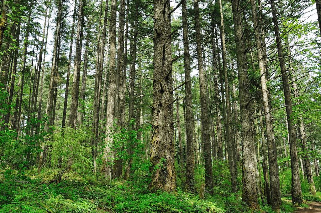
The Coastal Douglas Fir ecology that is predominant across the Saanich Peninsula is home to a rich variety of unique and endangered plants. The Douglas fir reigns supreme in the forests of Gowlland Tod Provincial Park with different companion trees depending on the localized conditions.
Among the rocky and dry uplands of Gowlland Tod Provincial Park, the Douglas fir is accompanied by arbutus and Garry oak, which are found nowhere else in Canada.
Garry oak forms an unusual ecosystem in which the oaks themselves form an open canopy above meadows of grass and wildflowers. Some of the beautiful flowers that form as a result of this canopy include camas, shooting star, easter lily, satin flower, as well as the endangered golden Indian paintbrush and the deltoid balsamroot.
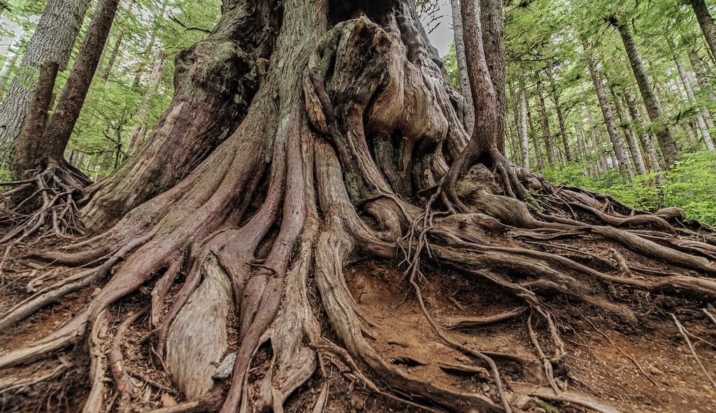
The steep valleys of Gowlland Tod Provincial Park retain their moisture better than the upland, allowing Douglas firs to grow alongside massive western red cedars, alder, bigleaf maple, and western flowering dogwood. The rich understory includes sword fern, salmonberry, and trillium. The rare and fascinating phantom orchid has also found a place among the damp and shaded areas of Gowlland Tod Provincial Park.
Among the dry uplands and moist valleys a wide variety of animal species make their home in the park, including over 100 different bird species. Some of the birds that inhabit the park are great blue herons, bald eagles, and the rare turkey vulture, Peale’s peregrine falcon, and Hutton’s vireo.
Black-tailed deer, red squirrels, black bears, cougars, mink, and raccoon make their homes in Gowlland Tod Provincial Park. Salmon pass through the Saanich inlet on their way to Goldstream River each fall. You may also spot sea lions, otters, harbour seals, orcas, and the occasional grey whale in the inlet.
Evidence of human habitation on Vancouver Island dates back over 4,000 years. Among many First Nations on the island, there is a common origin story that tells of a great flood. Many contemporary First Nations on the island tell that their ancestors were saved from the flood by getting into canoes that were tied up to prevent them from washing away.
Gowlland Tod Provincial Park is part of the traditional territory of the Saanich and Malahat First Nations which are both Coast Salish First Nations. The relatively small park contains many significant archaeological sites, particularly along its shorelines, including midden heaps and two village sites that are an estimated 1,500 years old.
The park contains a number of important cultural sites for the Saanich and Malahat First Nations. This includes the traditional medicinal plant harvesting grounds in the region, as well as locations with ceremonial and spiritual importance.
The history of the colonial settlement of Vancouver Island can be seen through the pioneer copper mine in Gowlland Tod Provincial Park. Additionally, there is the Caleb Pike homestead, which was built by Caleb Pike and his two sons in 1883. The Pike family were among the first settlers of European descent in the Highlands community.

Adjacent to Gowlland Tod Provincial Park is the historic Butchart Gardens on Brentwood Bay. These were created by Jenni Butchart, the visionary wife of Robert Butchart, who started the Vancouver Portland Cement Company at Tod Inlet.
As the limestone was quarried from their property, Jennie imagined filling the exhausted quarry with a garden. Bringing in topsoil by horse, Jennie slowly created the Sunken Garden, planting a variety of lovely flowers and other plants. The gardens have expanded and grown and are now a beautiful National Historic Site of Canada.
After Victoria hosted the Commonwealth Games in 1994, a heritage fund was created to commemorate the games. These funds were used to develop Gowlland Tod Provincial Park in 1995. The park was designated to “preserve a heritage of green space for future generations,” and as such, the park is used regularly by locals who want to enjoy the region’s stunning natural landscapes.
While Gowlland Tod Provincial Park is relatively small, it packs a lot of value into the many short trails, all of which offer incredible wilderness and viewpoints. The following are some of the major trails and attractions of Gowlland Tod Provincial Park:
The Jocelyn Hill Trail Loop is a popular 8.9 km (5.3 mi) trail that summits both Holmes Peak and Jocelyn Hill with only 438 m (1,436 m) of elevation gain throughout the hike. The trail first winds through the valleys of giant Douglas fir, western red cedars, alders, and bigleaf maples until you climb to the top of the ridge.
The ridge is a unique environment of dry meadows and rocky outcrops where the arbutus and manzanita trees flourish in the shallow soil. There are incredible views along the ridge that overlook the Findlayson Arm of the Saanich Inlet. These views also extend across the inlet to the Cowichan Valley Regional District.

The Squally Reach viewpoint is a value-packed hike through Gowlland Tod Provincial Park. Starting from a trailhead off the road, this nearly 2 km (1.2 mi) trail passes through an incredible coastal Douglas Fir forest where you may trip while walking as you find yourself staring up at the giant trees surrounding you.
The trail continues up to the ridge of the Gowlland Range where it opens to rocky outcrops and grassy meadows. Arbutus trees stand as solitary sentinels at the top of the hill, which overlooks the Saanich Inlet, the Gulf Islands, and the Malahat Boardwalk.
Starting from the Timberman Trail Trailhead in Mount Work Regional Park, this 3.4 km (2 mi) out-and-back trail takes you down some stairs, past Cascade Falls and out the shore along Mckenzie Bight. While the trail is steep, if you take your time and have a rest to enjoy the view, you’ll get to see some incredible sights on this short trail.

There are 25 km (15 mi) of maintained trails across the park that meander around, loop, and otherwise make a labyrinth through the Gowlland Range. It is easy to get lost amongst the multitude of trails; however, while wandering you’re likely to come upon some amazing viewpoints.
Some of the worthwhile viewpoints to hike to in Gowlland Tod Provincial Park are Elbow Point, Mckenzie Bight, and Tod Inlet. The summits of Jocelyn Hill, Cole Hill, Holmes Peak, and the Partridge Hills offer incredible views of the region. Additionally, the Malahat and Squally Reach viewpoints look out over the Saanich Inlet and towards the Gulf Islands and the Cowichan Valley Regional District.

Gowlland Tod Provincial Park is in the Capital Regional District on Vancouver Island, British Columbia and is adjacent to the most populated area of the island. The following are some of the nearby cities and communities to stay at or visit while at Gowlland Tod Provincial Park.
If you’re lucky, you’ll have friends or family that live in the Highlands, because Gowlland Tod Provincial Park, as well as several other provincial and regional parks, are only minutes away. The Highlands is home to the Caleb Pike homestead, which was built in 1883. It is now a national historic place and there are easily over 100 unique hikes within 10 km (6 mi) of the Highlands.
Down the road from the Highlands is the city of Langford where you can find all the services and accommodation a tourist may need. Near the city are Goldstream and Gowlland Tod Provincial Park, Thetis Lake and Mount Work Regional Park, and the world famous Butchart Gardens.
Victoria, the capital city of British Columbia, started as a Hudson’s Bay Company fort in 1843 and grew into a stunning colonial city that still maintains many of its beautiful historic buildings. Along the edges of the Victoria Harbour are the Provincial Legislature Building, which was built in 1897, and the iconic Empress Hotel, which opened in 1908.
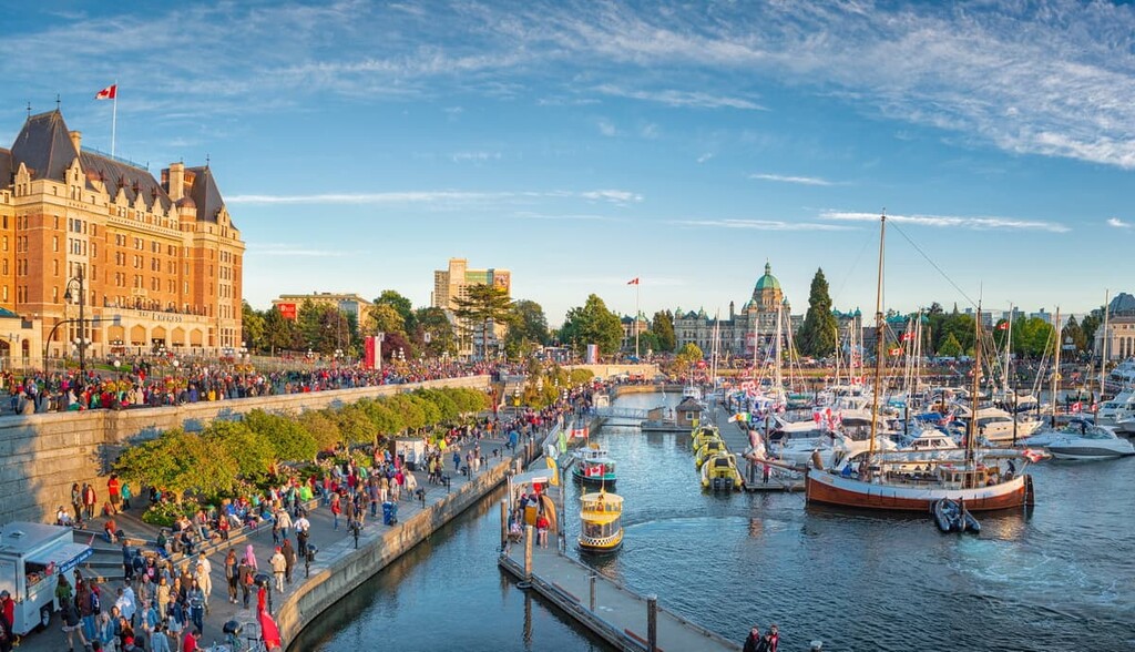
Furthermore, the downtown area has some lovely walks along the seaside. You can also check out some of the nearby attractions, which include Miniature World, the Victoria Bug Zoo, the Royal BC Museum, or the totem poles at Thunderbird Park.
Gowlland Tod Provincial Park is only 20 km (12 mi) away from downtown Victoria and there are numerous other parks and natural areas nearby that are worth visiting. This includes East Sooke Regional Park, Sea to Sea Regional Park, Goldstream Provincial Park, and Sooke Potholes Provincial Park.
Located on the north end of the Saanich Peninsula, Sidney is only 22 km (13.2 mi) from Gowlland Tod Provincial Park. While considered part of Greater Victoria, Sidney has a charming small town feel and it’s a great place to stroll downtown or to walk along the shoreline.
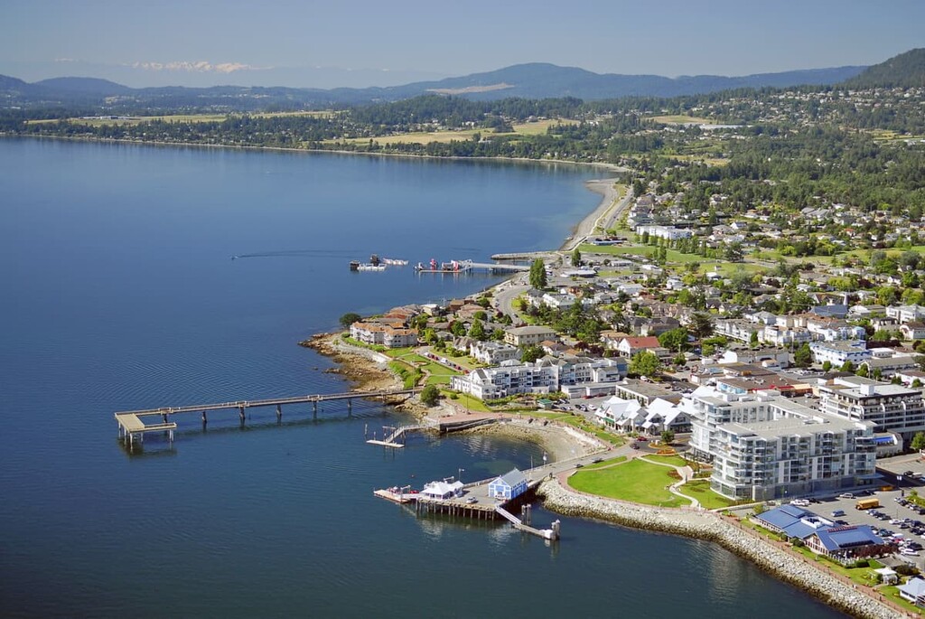
Part of the Sidney charm is all the town’s bookstores, as well as its many coffee shops where, after purchasing your new book, you can unwind. Or, if you’d prefer, there are benches along the pier where you can watch people crabbing and fishing..
Just north of Sidney is the ferry terminal at Swartz Bay, where you can board a ferry to one of the many destinations in the Gulf Islands. You can Island hop and see the various parts of the Gulf Islands National Park Reserve. Or, you can find your way to Salt Spring Island to discover the beautiful beaches and Mount Maxwell Provincial Park.


