
Scan the QR code and open PeakVisor on your phone
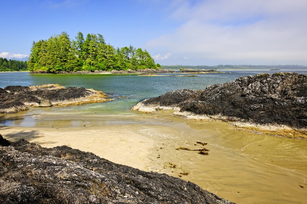
Home to the longest beach on Vancouver Island, the Long Beach Unit of the Pacific Rim National Park Reserve is a 16 km (10 mi) long sand beach that’s located on the west coast of British Columbia, Canada’s largest Island. The Long Beach Unit of the reserve has only two notable hills, Radar Hill and Vargas Cone, the latter of which is a remnant of the region’s volcanic past.
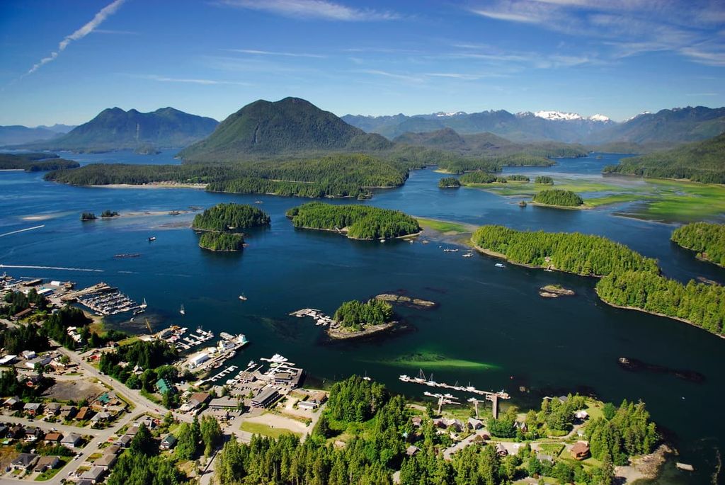
Located on the west coast of Vancouver Island, in British Columbia, Canada, Long Beach is one of three units in the Pacific Rim National Park Reserve. The other units of the reserve are the West Coast Trail and the Broken Group Islands.
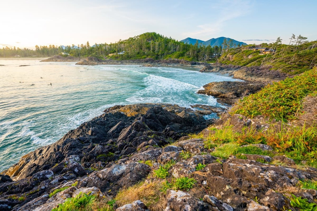
With 16 km (10 mi) of sandy beaches stretching through Florencia Bay, Wickaninnish Cove, Combers Cove, and Schooner Cove, Long Beach is the longest beach on Vancouver Island. Open to the ferocity of the Pacific Ocean, the beach was established as one of the earliest and most popular surfing locations in British Columbia.
Within the Long Beach Unit, there are two notable hills. Radar Hill is the tallest point in the unit with 123 m (404 ft) of elevation and Vargas Cone is the other high point in the area. Most of the visitors come to the park to surf, walk the beach, or hike the West Coast Trail. Other parks and hiking areas situated near Long Beach include:
Pacific Rim National Park Reserve is situated upon the unique Pacific Rim Terrane. The Pacific Rim Terrane is one of several trranes that make up Vancouver Island.
Most of Vancouver Island consists of the Wrangellia Terrane, which arrived on the west coast of Canada about 100 million years ago. Some time later, the Crescent Terrane and the Pacific Rim Terrane were accreted to the west coast of the island.
The Pacific Rim Terrane was accreted to the west coast of Vancouver Island about 55 million years ago and the Crescent Terrane arrived about 42 million years ago.
The collision of these terranes pushed Vancouver Island closer to the mainland, which resulted in the uplift of sediments to create islands in the Strait of Georgia and the uplift of the Vancouver Island Ranges.
Having formed as a volcanic island arc during the Triassic and Jurassic, the Pacific Rim Terrane is composed of metamorphosed sedimentary and volcanic rocks. The terrane subducted beneath the Wrangellia terrane, leaving only small remnants visible on the surface. This terrane is found across Pacific Rim National Park Reserve in Long Beach, the Broken Group Islands, and along the coastline that’s traversed by the West Coast Trail.
The ecology of the Pacific Rim National Park Reserve is representative of the Coastal Western Hemlock ecosystem. This ecosystem is prevalent along the lower elevations of the Canadian west coast and features the western hemlock and amabilis fir as the dominant climax trees.
The abundant rainfall and warm climate in the region make the west coast forests the most productive in Canada. The northern latitude rainforests are famous for the Douglas fir, which can approach heights of 100 m (330 ft). They are also famous for their massive western red cedars and Sitka spruce, which reach up to 4 m (15 ft) in diameter.

While hiking the rainforest trails, black-tail deer are the most likely animal that you will see while in the park. Black bears, the Vancouver Island wolf, raccoon, cougar, marten, mink, short-tailed weasel, and river otter are other terrestrial mammals that visit and inhabit the park.
Sea otters historically inhabited the waters of the park and the entire north Pacific coast from Japan to Alaska, and down the coast of British Columbia to California. Due to the high demand for otter pelts through the eighteenth and nineteenth centuries, the animal was virtually extinct by 1830.

The last recorded sighting of original sea otters in British Columbia occurred in 1929; however, reintroduction of the species to British Columbia has been successful. A colony was reintroduced at the north end of the island and is growing and splitting. As a result, it’s expected that sea otters will once again recolonize the waters of the Pacific Rim National Park Reserve.
Whales, sea lions, and seals inhabit the waters of the park and are the most spotted mammals. California sea lions, Steller’s sea lions, and harbor seals are common and northern fur seals and northern elephant seals are occasionally spotted.
Orcas are spotted throughout the park, as are humpbacks, sperm whales, dolphins, and porpoises; however, gray whales are the more common cetacean species in the region. Gray whales are most predictably spotted during the spring, as they migrate north through the park.
Commercial whalers nearly destroyed this west coast population of gray whales in the early 1900s. Having been reduced to only a few hundred individuals, the Pacific herd is now an estimated 20,000 strong. This herd represents the only significant known population of gray whales in the world.

Vancouver Island was likely ice-free and inhabitable between 12,000 and 13,000 years ago, and trees were recorded growing in the region as early as 13,500 years ago. However, the changing sea levels, dense vegetation, and the wet climate of the region have made it difficult to uncover the archeological remains of the island’s prehistory.
Archeological evidence suggests that Vancouver Island has been continuously inhabited for the past 10,000 years; however, the west coast of the island has less archeological data to base estimates on. Cultural materials that have been discovered along the west coast span the past 4,500 years.
The west coast of Vancouver Island is the traditional territory of the Nuu-chah-nulth First Nation. It was the Nuu-chah-nulth who inhabited Nootka Sound when Captain James Cook made the first recorded landfall by a European on the island in 1778.

As the first Indigenous people that the Europeans met on the island, the Nuu-chah-nulth were especially affected by the smallpox epidemics that killed an estimated 90 percent of the island’s indigenous population. British, Spanish, and Russian ships soon started sailing the waters of the Pacific Northwest in search of sea otters and other animals for their furs.
While Nootka Sound was the place where Europeans first made landfall on Vancouver Island, the general rugged nature of the west coast was less than ideal for settlement. Therefore, most major settlements were developed on the interior coast of the island. The west coast has remained largely unpopulated except by small communities who make their living in the fishing or forestry industries.
One of the major modern attractions of the west coast of the island is the West Coast Trail, which was originally created as a life saving trail for sailors who were shipwrecked along the coast during the eighteenth, nineteenth, and twentieth centuries.
The first road access to the west coast was only built in 1959 with the opening of a forestry road. The road was initially only usable on the weekends, after the logging trucks were parked for their drivers’ days off. However, as word of the incredible beaches and the massive waves spread, the area was soon filled with people looking to catch the next wave.
With the establishment of Pacific Rim National Park Reserve in 1970, tourism began to increase. The surf spots and the incredible beauty of the region was irresistible for many; however, Long Beach wasn’t put on display for the world to see until 2009.
In 2009, Pete Devries, a Tofino local, crushed the competition at the international event at his home beach. After the competition, surfers from around the world began to regularly arrive on the west coast, helping to build a local surfing tradition.

The sea and the shore are the major attractions at the Long Beach Unit of the Pacific Rim National Park Reserve. The following are some of the popular activities to check out during your next visit to the park.
Tourists have been coming in droves to Long Beach since a forestry road was first built to the coast in 1959. While wetsuits are required here for survival rather than just comfort, the massive swells that crash on the beach have been a surfer’s paradise for more than 60 years.
The beach draws surfers from across the island, country, and the world. Tofino is the self-proclaimed surf capital of Canada, and the title is well deserved. The frigid temperature, wind, and intimidating swell of the west coast has created many championship-level surfers over the years.

Whether it’s the winter or the summer, Long Beach is an incredible destination. While it is certainly more comfortable during the summer, with opportunities to walk, ride, bike, build a sandcastle, swim, view wildlife, beachcomb, sunbathe, or picnic, my favorite time to visit the beach is during winter.
As the coast is exposed to the ferocity of Pacific storms, massive waves break upon Long Beach during the winter. Care must be taken when visiting the beach during a storm; however, to be able to see such immense power and natural majesty is an amazing experience.

As it is located on the rugged coast of Vancouver Island, the Pacific Rim National Park Reserve draws visitors from across the world. The following are the major towns and cities near the park where you can look for accommodation, supplies, or professional guides for your next adventure.
Port Alberni is located at the head of the Alberni Inlet, about 100 km (60 mi) inland from Long Beach and the Pacific Rim National Park Reserve. The city is a good jumping-off point for many outdoor activities, such as marine and freshwater fishing, hiking, kayaking, and mountain biking.
There are several hiking trails in Port Alberni and over a hundred in the surrounding valley and mountains. Some of the popular hikes in the area are the Horne Lake Trail, Log Train Trail, and the Inlet Trail. Mount Arrowsmith is located nearby if you want to hike the Saddle Trail or climb to the summit.

It can often be difficult to find accommodations in the coast-side communities of Tofino and Ucluelet, but Port Alberni is only 100 km (60 mi) away. With many of its own trails and outdoor activities, Port Alberni is the gateway to the rugged and wild west coast of Vancouver Island and is worth visiting in its own right.
Located on the west coast of Vancouver Island at the end of Highway 4 and at the edge of Clayoquot Sound, Tofino is a year-round tourist destination; however, the population swells significantly in the summer. The area attracts surfers, campers, backpackers, hikers, mountain bikers, whale watchers, bird watchers, and anybody that wants to enjoy nature.
Long Beach in the Pacific Rim National Park Reserve, is situated near Tofino and is especially popular with surfers. While the summer is popular because the weather is warm, the winter season gives an incredible display of the ocean’s power during the winter storms. Massive waves can be seen rising above and smashing into the west coast of the island near Tofino.
Located on the Ucluelet Peninsula on the west coast of Vancouver Island, Ucluelet, like Tofino, has become a year-round tourist destination. Long Beach and the Broken Group Islands of the Pacific Rim National Park Reserve are located on either side of the community, in addition to other trails and attractions.
Some of the activities to do while in Ucluelet are surfing, fishing, camping, hiking, kayaking, swimming, and beach combing. The winter storms from November to March are a sight to behold and it’s worth making a visit to the area in the winter.
Long Beach is popular for surfing and other beach activities. Other places to surf include along Florencia Bay and Wickaninnish Beach. If you’d prefer hiking, the Wild Pacific Trail is a regional trail that begins near the mouth of the Ucluelet Inlet. It travels along the Pacific coastline through Big Beach Park and ends just outside Ucluelet. The path is well maintained and there are stunning coastal views to enjoy along the way.


