Scan the QR code and open PeakVisor on your phone
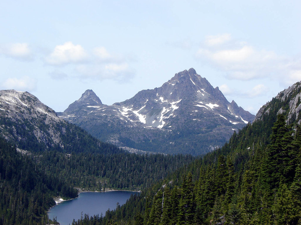
The west coast of Vancouver Island in British Columbia, Canada is home to many unique wilderness parks and geological features, including Sydney Inlet Provincial Park. Sydney Inlet is one of the best examples of a coastal fjord on Vancouver Island. At the head of the inlet sits Sydney Cone (986 m/3,235 ft), the only peak in the park.
Located on the west coast of Vancouver Island, Sydney Inlet Provincial Park protects one of the best examples of a coastal fjord on Vancouver Island. The park is situated in the Alberni-Clayoquot Regional District of British Columbia.
Sydney Inlet Provincial Park protects a diversity of habitats, including steep cliffs, deep coastal waters, portions of a neighboring river and estuary, and old-growth forests. The only mountain in the park is Sydney Cone, which is 986 m (3,235 ft) tall and has 629 m (2,064 ft) of prominence.
Port Alberni, Tofino, and Ucluelet are the major communities that are located near the park. Sydney Inlet Provincial Park, like many of the parks in the region, is only accessible by boat or seaplane. The following are some of the parks found near Sydney Inlet that are also worth checking out if you’re in the area:
The major geologic formation on Vancouver Island is the Vancouver Island Ranges, which formed from rocks that are part of an ancient terrane called Wrangellia. Wrangellia is an exotic terrane that collided with and accreted to North America about 160 million years ago.
This terrane primarily consists of volcanic flood basalts that formed after volcanoes erupted about 250 million years ago; however, there are volcanic and sedimentary layers in the terrain that date back around 350 million years. At some point in the history of the island, possibly when the Pacific Rim terrane was subducting beneath Vancouver Island, volcanic events created the Sydney Cone, which is currently located at the head of its namesake inlet.
During the Pleistocene, glaciers and ice sheets covered the island to an elevation between 1,000 m (3,280 ft) and 1,500 m (4,920 ft). In other areas of the island, some of the peaks are monadnocks that stood above the ice sheets. Glaciers eventually flowed down the inlet, carving out the steep cliffs that we see today.
At the end of the Pleistocene, the glaciers in the region started to melt, which caused the sea level to rise. The rising ocean filled many of the valleys on the west coast of mainland British Columbia and Vancouver Island, creating the fjords that we have today, such as the Sydney Inlet.
Sydney Inlet Provincial Park is home to old-growth Sitka spruce and Douglas fir forests, beaches, riparian habitats, steep cliffs, a volcanic cone, and the river estuary that’s located at the head of the inlet. The park has many habitats that provide homes for a variety of wildlife, including dozens of mammal, fish, bird, reptile, and amphibian species.
Much of the landscape within the park is part of the Coastal Western Hemlock zone, which covers the majority of Vancouver Island. This zone is filled with forests of western hemlock, red cedar, and Douglas fir. In particular, the park has a high concentration of ancient forests that include massive Sitka spruce and Douglas fir trees.
The river and estuary in the park both support considerable salmon runs, which includes a sizable chinook salmon population. Other fish species in the park include cutthroat trout, steelhead, rainbow trout, and sculpin.
The mudflats in the park also contain clam and oyster beds as well as food for the many birds of the area. Some of the many bird species found in the area include geese, swans, ducks, bald eagles, great blue herons, black oystercatchers, alcids, and other shorebirds.
Bats, black bears, cougars, wolves, and elk are all found in the park as are many communities of rare plants. Dwarf trillium is endemic to the west coast of Vancouver Island and is found in Sydney Inlet Provincial Park.
There is archeological and cultural evidence that the territory in and around Sydney Inlet has been inhabited for at least 4,000 years. In particular, the Nuu-chah-nulth First Nations consider the area to be part of their traditional territory.
Nuu-chah-nulth First Nations traditionally hunted grey and humpback whales in the waters around what is now the park. While other whale species were easier to hunt, many members of the Nuu-chah-nulth First Nations would show their bravery by hunting orcas.
Sydney Inlet Provincial Park is rich in cultural sites that represent both the First Nations heritage and that of the European settlers who arrived in the region much later. Along with village sites, campsites, and other First Nations cultural sites, the park is home to the Lord Western and the Sydney Inlet mystery wreck.
The Nuu-chah-nulth First Nations includes members of 14 different band governments, 9 of which have headquarters or large settlements in the Alberni-Clayoquot Regional District. The Nuu-chah-nulth have also been called the Nootka, which was a name given to them after their first encounters with Europeans in 1778.
In 1778, Captain James Cook was the first European to make and record landfall on Vancouver Island. This made the Nuu-chah-nulth among the first Indigenous people who lived to the north of what is now California to encounter Europeans.
By 1830, barely 50 years since the first European contact, more than 90 percent of the Nuu-chah-nulth had died from malaria and smallpox, which were introduced by European sailors. By the early twentieth century, it’s believed that the population of the Nuu-chah-nulth First Nations was only 3,500 people.
While trading posts were built in the area to facilitate the harvesting and trading of furs for the Hudson’s Bay Company, anchoring was difficult in the Sydney Inlet. This likely aided in its preservation from logging and settlement by European traders.
While other massive trees in the region drew logging companies to harvest them, the forests surrounding Sydney Inlet would remain relatively untouched over the past several centuries of settlement and colonization. The area is now protected, and, as such, it is a region that is popular among scientists working on a number of environmental and climate-related projects.
Sydney Inlet Provincial Park is home to several natural features that make the park a worthwhile destination for outdoor recreation. While it is only accessible by boat or floatplane, the inlet provides a nice area for kayakers to camp and rest after a long day of adventure.
Wilderness backcountry camping is permitted year-round in the park and visitors are encouraged to practice Leave No Trace camping principles to protect the natural environment. While visiting the park, there are opportunities for ocean swimming, wildlife viewing, fishing, and hunting, though there aren’t many maintained trails in Sydney Inlet.
Some visitors may attempt the trek to view the Sydney Cone at the head of the inlet while others may just want to rest along the scenic shoreline. Keen naturalists will likely appreciate the opportunity to view some of the rare and unusual flora and fauna that inhabits the park.
The rugged west coast of Vancouver Island is incredibly scenic and it features many incredible destinations. Here, ancient forests, volcanic cones, incredible beaches and hiking trails, and amazing scenery await adventurous visitors.
The following are some of the towns and cities located closest to Sydney Inlet Provincial Park that are worth checking out during your trip to the region.
Named after Don Pedro de Alberni, commander of Fort San Miguel at Nootka Sound from 1790 to 1792, Port Alberni is the largest city located near Sydney Inlet Provincial Park. The city is situated about 100 km (60 mi) to the south of the park and is in the territory of the Tseshaht First Nation and the Hupacasath First Nation of the Nuu-chah-nulth Tribal Council.

Logging is integral to the local and regional economy; however, in recent years, Port Alberni has started shifting its economic focus to draw in and capitalize on tourism to the area. Port Alberni is located within a beautiful wilderness where marine and freshwater fishing, hiking, kayaking, and mountain biking are all activities that can be easily enjoyed.
There are several hiking trails in Port Alberni and over a hundred in the surrounding valley and mountains. Some of the popular hikes in the area include the Horne Lake Trail, Log Train Trail, and the Inlet Trail. Mount Arrowsmith is also nearby if you want to hike the Saddle Trail or climb to the summit.
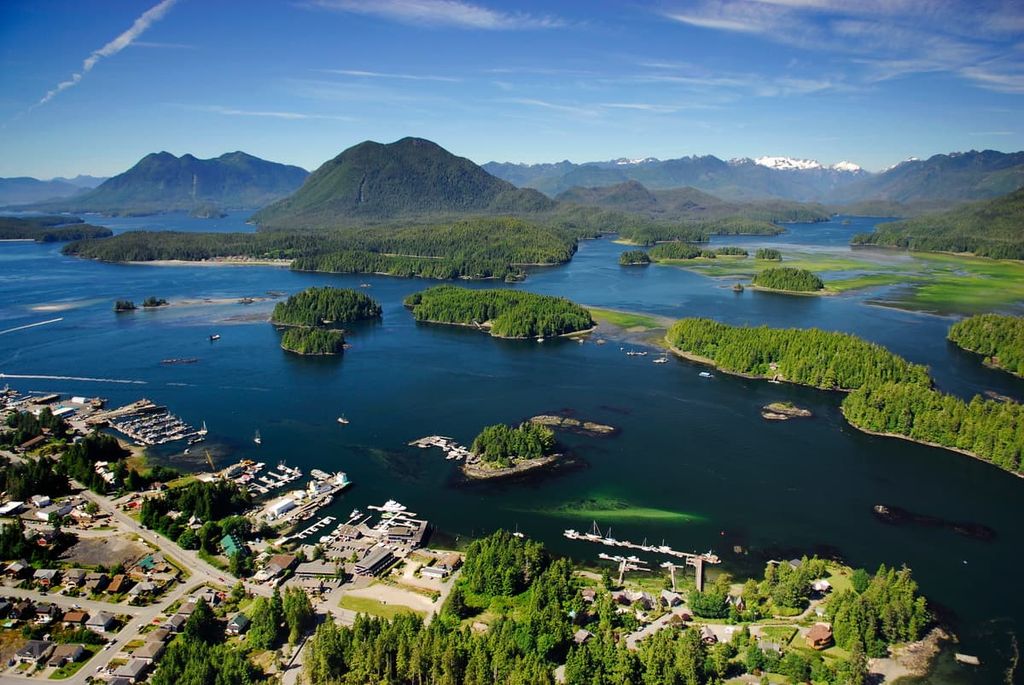
Located on the west coast of Vancouver Island at the end of Highway 4 and at the edge of Clayoquot Sound, the community of Tofino is a year-round tourist destination that attracts surfers, campers, backpackers, hikers, mountain bikers, whale watchers, bird watchers, and anybody that wants to enjoy nature.
Long Beach, which is located in Pacific Rim National Park Reserve, is also located near Tofino, and it is especially popular with surfers.
While the summer in Tofino is popular because the weather is warm, the winter season offers a chance to see an incredible display of the ocean’s power during winter storms. In fact, during the winter months, massive waves can be seen rising above and smashing into the west coast near Tofino.
Located on the Ucluelet Peninsula on the west coast of Vancouver Island, the community of Ucluelet is a year-round tourist destination. Long Beach and the Broken Group Islands of the Pacific Rim National Park Reserve are located on either side of the community, as are other trails and attractions.
The community attracts visitors who want to go surfing, fishing, camping, hiking, kayaking, swimming, and beachcombing. The winter storms that batter the area from November to March are also a sight to behold, so it’s worth making a visit to the area in the winter.
Nearby Long Beach is a particularly popular area for surfing and other beach activities. Alternatively, if a land-based adventure is what you seek, check out the Wild Pacific Trail, a regional trail that begins near the mouth of the Ucluelet Inlet. It travels along the Pacific coastline through Big Beach Park and ends just outside Ucluelet. The path is well maintained and there are stunning coastal views to enjoy along the way.