

Share

Scan the QR code and open PeakVisor on your phone
Scan the QR code and open PeakVisor on your phone
Fourteeners in the mountaineering world are defined as mountains having a height greater than 14,000 feet (4267 Meters). That includes all mountains above that, even those that are twice as high (only three worldwide qualify for that distinction). Note, however, that the “magic” number is in feet and not meters. That clearly then speaks to mountains in countries that usually state their height in that unit of measure, i.e. countries that use the Imperial System of Measurement. People who hike and climb in the Alps, for example, measure their mountains in meters, where 4,000 is the “magic” number (there are no mountains in the Alps that reach 5,000 meters).
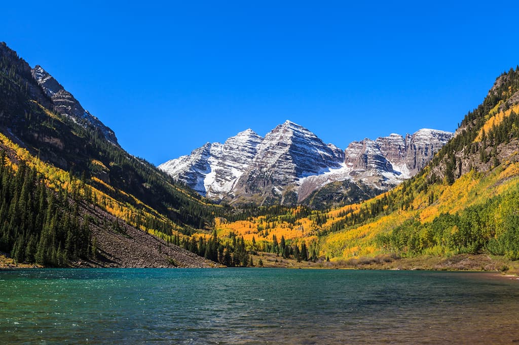
Maroon Bells, Colorado
Consequently, when we talk about fourteeners (or 14ers if you prefer), we talk mainly about mountains fitting the category in North America and more specifically, the United States. Furthermore, the criteria for qualifying as a fourteener are different in Alaska than in the other three states that have them (Washington, California and Colorado). It is not just the elevation above sea level that counts, however; it is the topographic prominence that also plays a role and that is what differentiates Alaska from the other three states. Alaska uses the 500-foot prominence rule whereas the others use the 300-foot rule.
Obviously, if a named mountain is at or above 14,000 feet but does not satisfy the prominence rule, it is not an “official” fourteener. By this rule, the state of Colorado has by far the most fourteeners, 53 in all (although it has 60 named mountains over 14,000 feet) – more than the other states combined. Alaska has 16, California has 12 (although, depending on the source, one is not quite 14,000 and one is one foot under the prominence criteria) and Washington has two (which are actually two separate summits of the same mountain, yet with enough prominence to qualify). This results in a total of 83 fourteeners in the United States. In each of the four states, the highest mountain is also the most prominent, as well as being ultra-prominent: Alaska (Denali), California (Mount Whitney), Washington (Mount Rainier) and Colorado (Mount Elbert). Denali is the highest mountain in North America, while Mount Whitney is the highest in the “lower” 48 states and Mount Elbert is the highest mountain in the Rocky Mountains of North America.

Mount Elbert, Highest Summit in the Rocky Mountains
So why are fourteeners so popular? Because they are there (to borrow a famous phrase from George Mallory) and because people want to climb them – more specifically, they want to “bag” them. Colorado is especially a “peak-bagger” domain since it is possible to climb all of them without any special gear or experience, other than stamina and common sense, though, of course, there are technical routes on many of them. I have climbed 17 of them, several more than once, and although I would like to climb some others, I now leave that to those who are younger and more energetic than I am these days. So let’s first talk about the fourteeners in the other states before we attack Colorado, which I think is where the term was first coined, or at least where it has the most significance and enjoys the biggest following.
Alaska is like a different planet. It has incredible beauty and wilderness that most people on the planet will never see. While it has the highest mountains in the country, its average elevation ranks only 15th of the 50 states, whereas Colorado ranks first. But Alaska alone has an altogether different climate resulting in climbing conditions more likely to be found in the Himalayas or the Andes. It is truly an arctic environment with resulting climbing conditions suitable only for experts who are trained and equipped to do serious ice and snow climbing. Even then, there are accidents despite the best preparations. Therefore, these mountains are definitely not for recreational hikers, and those that try despite these constraints are not likely to survive.

Denali, Highest Mountain in North America
The mountains in Alaska are not for peak-baggers and, aside from Denali, are not really well-known to most of us in the “lower 48”. Many of these highest mountains in the state are massive, have major prominence and look stunning – when they can be seen. Those on the Pacific Coast are immense in terms of their vertical relief, since they seem to rise right from the shoreline. Since PeakVisor is focused mostly on recreational hiking and climbing, we will leave discussion about specific climbing routes in Alaska to others.
The northwestern state of Washington is not known for its fourteeners. Mount Rainier and its sub-peak Liberty Cap are in fact the only ones in the state. It is the fifth-highest fourteener in the “lower 48”, exceeded only by Whitney in California and by Elbert, Massive and Harvard in Colorado. Yet its climbing conditions more resemble those of Alaska than any of the other fourteeners in the country, of which it is the most topographically prominent mountain. It is considered one of the most dangerous volcanoes in the world due to its large amount of glacial ice. In the event of a major eruption, it could produce massive lahars thus endangering a major population center, where 80,000 people could be at risk.

Mount Rainier, Washington
Climbing Mount Rainier is dangerous to say the least, with all climbing routes requiring technical climbing skills. Whereas you can climb most fourteeners in Colorado in less than a day, climbing Rainier will take two to three days – if the weather cooperates. The success rate for reaching the summit is about 50%. Most failures to reach the summit are due to weather and lack of physical conditioning or experience. There are regulations for all climbers, including a requirement for permits. Experience in glacier travel, self-rescue and wilderness travel are obvious prerequisites for climbing teams and solo climbers. Mountaineering deaths are an annual occurrence on this mountain. So needless to say, this one is not for casual hikers.
But that is not to say that casual hikers cannot enjoy Mount Rainier. There are many miles of hiking trails on the lower slopes surrounding the mountain, even one trail, the Skyline Trail, which encircles the entire mountain. The Paradise area on the south side of the mountain is particularly popular, offering many hiking options for all levels of skill and conditioning. Therefore, hikers should not be discouraged from coming to this mountain just because the upper slopes are so dangerous. Mount Rainier, along with the national park of the same name, is a very fine visitor destination that affords so many hiking opportunities that most visitors would not even think of attempting to climb this monster of a mountain. Just looking at it is a feast for the eyes and will give many of us ample pleasure and satisfaction as we tramp along the many trails.
Of the 12 “official” fourteeners in the Golden State, there are two that grab the lion’s share of attention when it comes to climbing – Mount Whitney and Mount Shasta. Ranked numbers one and five in elevation, these two mountains are 400 miles apart, thus in somewhat different environments. Shasta is a potentially active volcano while Whitney is basically a solid block of granite with extremely steep eastern slopes. Ten of the fourteeners are in the Sierra Nevada range which means this is where most climbers will gravitate to. Mount Shasta is in the southern part of the Cascade Range and White Mountain Peak is in the – you guessed it – the White Mountains, not one of the better-known ranges in California. We will confine our hiking descriptions to the two best known and most popular fourteeners, Mount Whitney and Mount Shasta.
Mount Shasta – The summer climbing season on Mount Shasta is generally from April to October although summit attempts are known to be made in winter. The five-mile (one way) Avalanche Gulch Route is the most popular for climbing the mountain. While this may not seem like a very long hike, it involves over 7,000 feet of elevation gain which makes it essentially a two-day ascent, with an overnight perhaps at the Helen Lake Campsite. Since this is in part a technical climb, it is not recommended for casual hikers. Depending on time of year, ice axes are needed, and helmets should be standard equipment at any time. Climbing permits are required as well as wilderness permits for any overnight stays in the wilderness. For non-climbers, there are many great hiking options around the mountain’s base, mostly on the south side which is easier to get to.

Mount Whitney – This highest summit in California is extremely popular among climbers. The most popular route is the Mount Whitney Trail which begins at Whitney Portal, 13 miles west of the town of Lone Pine. This route joins the John Muir Trail, which it follows along the crest of the Sierra to the summit. This route may be non-technical, but it is long and difficult. A round-trip hike of 22 miles with an elevation gain of 6,100 feet means that most hikers will need two to three days (one or two overnight stays) to complete the hike. Well-conditioned hikers often do this in a single day-hike taking up to 18 hours for the round-trip.

Mount Whitney, Sierra Nevada Range
Permits are required year-round and are issued on a lottery basis. So don’t drive to the trailhead and expect to hike without one. There are rangers that strictly enforce all restrictions on this hike. While the mountain looks formidable from the east, this trail is a walk-up – a very long one, yet it is the shortest way to the summit except for the Mountaineer’s Route, which is a Class 3 scramble beginning at the Whitney Portal as well. From the west, the summit can be reached via the John Muir Trail which begins in Yosemite National Park and passes through Sequoia National Park. Any approach to Whitney from the west will indeed be very long.
Given that Colorado has more fourteeners than the other states combined, it follows that this state should capture most of the attention of peak-baggers. But that alone is not the only reason – the fourteeners in this state are by far the most accessible and therefore the most climbed. Add to that the fact that most of these mountains are actually easily climbed by most people that are in reasonably good condition. Yes, there are a number of these high peaks that are consciously avoided by even well-conditioned and otherwise avid climbers due to their ominous reputations for being dangerous, despite the fact that they can be climbed on non-technical routes. On the other hand, all of these mountains need to be respected for a common reason – the Colorado weather. At the times of the year when these mountains are mostly free of other hazards such as snow and ice, here come the typical summer afternoon thunderstorms. Not every day, but they can turn up unexpectedly on any one day. I know - I got caught on top of the highest of them all when a storm unexpectedly developed. It was the fastest descent to treeline that I ever made.

Storm on Mount Elbert
There are many ranges in the Colorado Rockies and almost every one has at least one fourteener. Now keep in mind that if you draw a straight line across the state from south to north and passing through Denver, all fourteeners, in fact almost all mountains in the state, will be to the west of this line (which defines 57% of the state’s land area), although the line just encroaches on the eastern slopes of Pikes Peak near Colorado Springs. Let’s have a look at how these magnificent mountains are distributed across these high ranges. For handy reference, I would recommend an excellent book about climbing these mountains - “Colorado’s Fourteeners: From Hikes to Climbs” by Gerry Roach; it should be in every serious hiker’s library. Not only is it a great reference and trail guide, it is also enjoyable reading.
Sawatch Range – This backbone of Colorado has 15 fourteeners, more than any other range in the state. Ruling over them all is Mount Elbert, the highest mountain in the entire Rocky Mountains of North America. These mountains are often referred to as the “Gentle Giants” since they are mostly “walk-ups”, though of course they are quite strenuous. Perhaps the favorite of these fourteeners is Elbert itself simply because it is the highest. One of the easiest routes to the summit starts at the Halfmoon Campground only 11 miles from the town of Leadville, the highest city in the United States. The nine-mile round-trip hike following the northeast ridge involves 4,400 feet of elevation gain. It is a fairly easy Class 2 hike for those who are conditioned and acclimated to the elevation. But one need not necessarily climb the highest fourteener in the range to get maximum pleasure from hiking in these mountains. After all, even the lowest of all 53 fourteeners in Colorado is still a fourteener and demands respect. I speak of Huron Peak.

Huron Peak, Sawatch Range
San Juan Mountains – This largest and most remote range (at least in terms of its distance from the Front Range Urban Corridor) in Colorado contains 12 fourteeners and some of them are pretty serious climbs. In addition, some involve a rather complex and expensive approach even to get just to the trailhead. The highest is Uncompahgre Peak, which is considered unclimbable on its north side and is a fairly simple walk-up on the south. Perhaps the most popular fourteeners here are in the Needles Mountains sub-range, in the area known as Chicago Basin. The only viable way to get to the trailhead is by train – the famous Durango & Silverton Narrow Gauge Railway. You could hike in also but plan on spending several more days. The three peaks – Windom, Eolus and Sunlight – form an impressive wall around this flower-strewn basin complete with wildlife. This popular basin then serves as base camp for those seeking to climb all three of these fourteeners, affording the most common routes to all three, which are often considered the pinnacle of Colorado’s fourteener experience. But if you really want to get away from it all, the Wilson group contains the most distant fourteeners from Denver. They are part of the San Miguel Mountains, the most westerly sub-range of the San Juans, sometimes considered distinct from the rest of the range.

Wilson Peak, San Juan Mountains
Sangre de Cristo Range – This long, narrow range in south-central Colorado is home to ten fourteeners. Several of these are serious climbs that should not be attempted by other than experienced mountaineers. One mountain, Culebra Peak, is unique in that it is entirely on private property. Access to this mountain is limited to certain times and it will cost you to climb the peak - $150 per person. Some peak-baggers just skip this one, although it is said that this easy walk-up is as pristine as any mountain can be. It is located in the Culebra sub-range.
But the most popular climbing area in this range is in the Crestone Group, which can be reached from either the east or west side of the range. This group has some of the best technical routes in the state, yet offers several gentler walk-up hikes. Either way, this group of five fourteeners is rugged and remote. The view of the Crestones from the nearby San Luis Valley across the Great Sand Dunes is truly impressive. Alternatively, the Blanca Group further south affords some incredible climbing. The famous Blanca-Little Bear Traverse is the most difficult traverse between fourteeners in the state. These peaks are not for novices.

Sangre de Cristo Range
Elk Range – This range that has five fourteeners is perhaps best known for the fact that it is home to the famous Maroon Bells, which are thought to be the most photographed mountains in North America. That is because they can be easily viewed by anybody who has the ability to get out of a car and walk about fifty steps. The view across Maroon Lake toward these massive peaks (only one of the two “Bells” is an official fourteener, the other not meeting prominence criteria) is sure to take your breath away. Every time I go there I find the view simply stunning, just as I did the first time I saw them. But climbing them is best left to experts only. While not technical in nature, it is the rotten geology that has resulted in many deaths on these “Deadly Bells”, as they are affectionately known.
By contrast, the easiest fourteener in the Elks is Castle Peak, which is also the highest. The delightful Snowmass Mountain is remote and is best climbed in conjunction with a backpack trip of at least three days, preferably from Snowmass Lake, which is how I did it, the only fourteener in the Elks that I have in my bag. For those who do not suffer from vertigo, Capitol Peak and its famous (or infamous) knife edge, will challenge any seasoned climber. And just beside Maroon Lake is Pyramid Peak – its easiest route is rated Class 4, so it is best not attempted by novices.

Castle Peak, Elk Range
Mosquito Range – This north-south trending range has five fourteeners, access to which is mostly from the east. These are popular mountains partly because they are among the easiest in the state. They can all be climbed on Class 1 routes with some easy Class 2 sections. The range includes Quandary Peak, the highest in the range, which has as of late 2019 claimed the distinction as the most climbed fourteener in Colorado. The McCullough Gulch Trailhead nine miles south of the ski resort of Breckenridge is where most hikers begin their conquest of this gentle giant. It is a popular winter climb.
Another very popular “beginner” fourteener is Mount Sherman; the trailhead is about 14 miles from the town of Fairplay and is at an elevation of 12,000 feet for those who have a 4WD or high clearance vehicle. Passenger cars can be driven as far as 11,250 feet. Some say this is the easiest fourteener in the state. Some people love it because it is so easy – others look down on it because it is so easy. The trio of Lincoln/Bross/Democrat is perhaps the most popular combination hike in which three fourteeners can be easily bagged in a relatively short hike. A fourth named summit, Mount Cameron, is also included in this hike despite the fact that it does not qualify as an official fourteener due to prominence criteria.

Quandary Peak, Mosquito Range
Front Range – This longest range in Colorado spans 175 miles north to south and includes six fourteeners, the highest of which is Grays Peak, which also holds the distinction of being the highest point on the Continental Divide of North America. In fact, Grays, along with its nearby sister, Torreys Peak, are the only fourteeners in North America that sit squarely on the Divide. All six fourteeners are highly popular for climbing, although Pikes Peak and Mount Evans owe their popularity as much to the fact that you can drive to the top of both of them. Grays and Torreys are easily climbed together from a high trailhead just a few miles off Interstate Highway 70 not far from Denver. These two fourteeners have been popular tourist destinations since the late 19th century.
Mount Bierstadt was until late 2019 the most climbed fourteener in Colorado, when Quandary Peak (see above) claimed that honor. Easily climbed from the summit of Guanella Pass just ten miles south of Georgetown and I-70, this is without question one of the easiest fourteeners in the country. Its proximity to Denver certainly contributes to this popularity.

Mount Evans, Mount Bierstadt, Front Range
Meanwhile, the northernmost fourteener in Colorado is Longs Peak – the sentinel of Rocky Mountain National Park. Highly popular with climbers, this mountain is not without its hazards, though it is at most a Class 3 climb – during the summer. In winter, even the “easiest” route, the Keyhole Route, becomes a technical climb. This is a tough climb and with its exposure and the ever present danger of lightning, this fantastic peak demands respect and is not for the casual hiker.

Longs Peak, Rocky Mountain National Park
According to the Mountaineering Club of Alaska, it is standard in Alaska to use a 500-foot (152 m) prominence rule rather than a 300-foot (91 m) rule. It helps to filter out some unnamed subpeaks of Denali and other less known summits. This is the most precise list of fourteeners as their prominences and elevations were meticulously calculated and triple checked by hand on high precision 1 arc second Digital Elevation Models.
The list of Alaska fourteeners:
According to most published lists, California has 12 official fourteeners. However, two of them could be debatable, depending on which list one wants to believe. Mount Muir meets the elevation criterion, but its prominence is variably reported as 299 feet and 331 feet. Mount Palisade, while easily meeting the prominence criterion, has its elevation reported as 13,996, 14,012 and14,014 feet. The variations in both criteria can sometimes be bewildering, but what is obvious is that most websites that one would commonly search for information on “official” fourteeners include these two; therefore, we include them as well.
The list of California fourteeners:
Because Colorado has so many fourteeners, and because “bagging” these monsters is almost an obsession with Coloradans as well as out-of-state visitors, we break the list down so that you can find more information with respect to which ranges (and commonly known sub-ranges) these summits inhabit. Fittingly perhaps, but not really relevant, the highest fourteener in the state, Mount Elbert at 14,439 feet, resides in the range that also “owns” the most fourteeners.
So here is the list of Colorado fourteeners:

Explore 14ers with the PeakVisor 3D Map and identify its summits.
14er
ultra
glacier
alaska-13ers
fred-beckey-great-peaks
alaska-ultras
14er
ultra
glacier
4000ers-canada
alaska-13ers
fred-beckey-great-peaks
canada-sampler
alaska-ultras
yukon-ultras
14er
ultra
alaska-13ers
alaska-ultras
14er
ultra
glacier
alaska-13ers
alaska-ultras
14er
ultra
glacier
volcano
alaska-13ers
alaska-ultras
14er
ultra
alaska-13ers
alaska-ultras
14er
ultra
4000ers-canada
alaska-13ers
alaska-ultras
yukon-ultras
14er
ultra
glacier
alaska-13ers
fred-beckey-great-peaks
alaska-ultras
14er
ultra
glacier
volcano
cascade-range-9000ers
washington-bulger
smoots-100
chemeketan-18-nw
mountaineers-6-peak-pin
mountaineers-5-peak-pin
cascade-volcanoes-pin
mazamas-16-nw-award
fred-beckey-great-peaks
washington-ultras
14er
ultra
4000ers-canada
11ers-bc
alaska-13ers
canada-sampler
british-columbia-ultras
alaska-ultras
14er
ultra
glacier
volcano
alaska-13ers
alaska-ultras
14er
ultra
glacier
4000ers-canada
alaska-13ers
fred-beckey-great-peaks
canada-sampler
alaska-ultras
yukon-ultras
14er
ultra
california-13ers
las-vegas-mountaineers-classics
porcella-burns
western-state-climbers
western-state-climbers-star
sierra-club-sierra-peaks-section
sierra-peaks-section-emblem
sierra-sampler
vagmarken-sierra-crest
fred-beckey-great-peaks
california-ultras
14er
ultra
glacier
volcano
cascade-range-9000ers
california-13ers
porcella-burns
western-state-climbers
western-state-climbers-star
chemeketan-18-nw
cascade-volcanoes-pin
mazamas-16-nw-award
fred-beckey-great-peaks
california-ultras
14er
ultra
4000ers-canada
alaska-13ers
alaska-ultras
yukon-ultras
14er
ultra
4000ers-canada
alaska-13ers
alaska-ultras
yukon-ultras

