
Scan the QR code and open PeakVisor on your phone
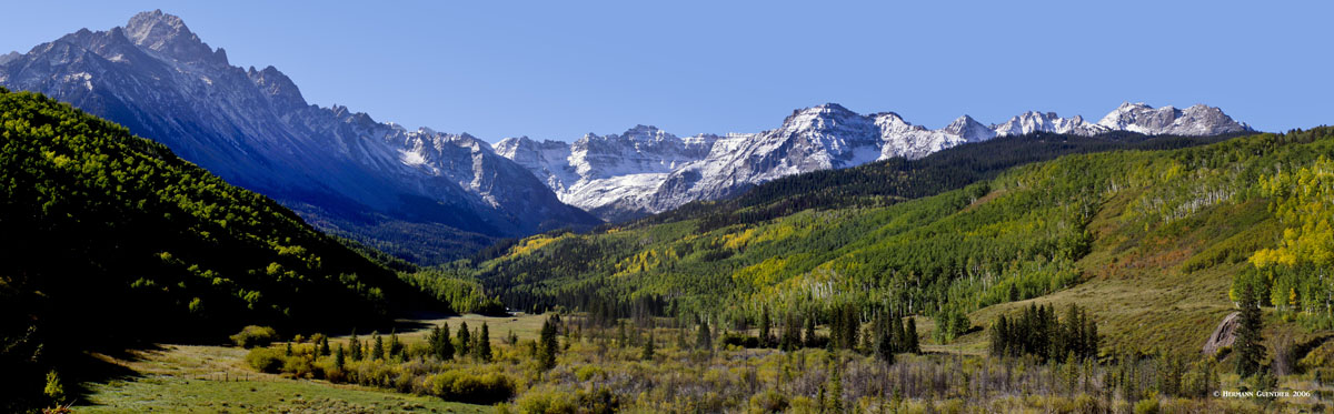
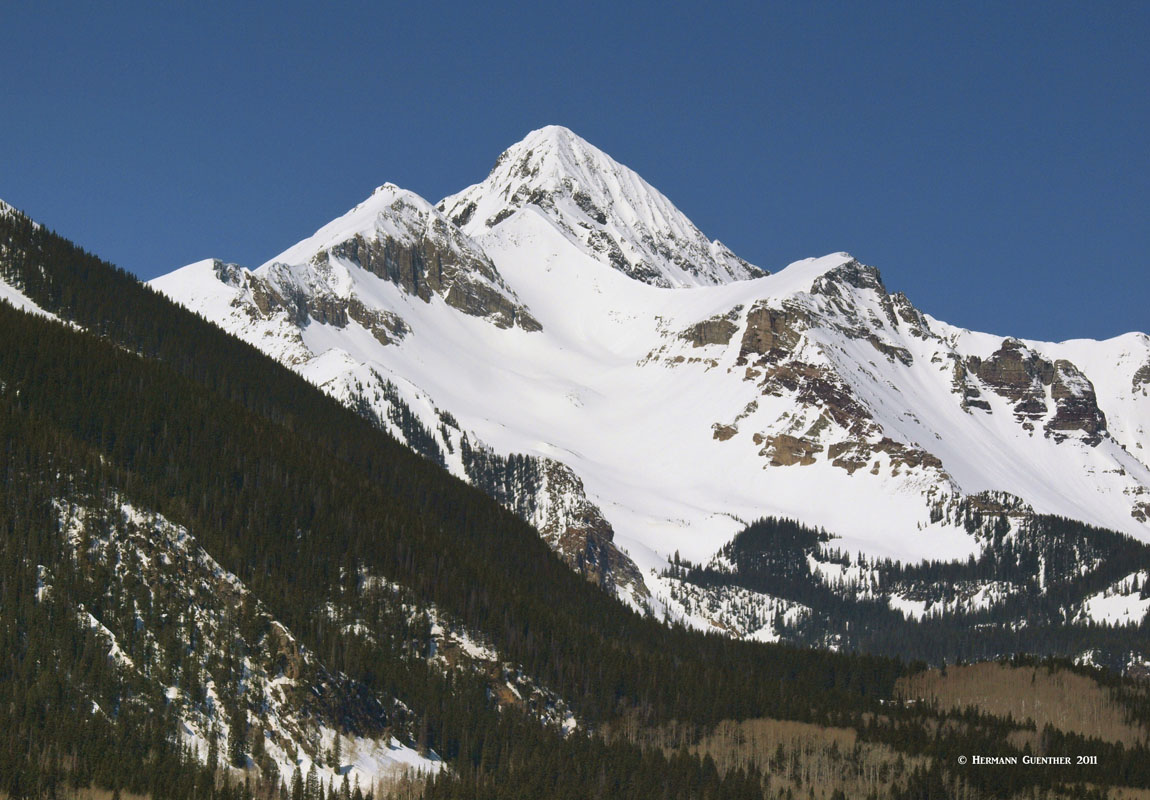
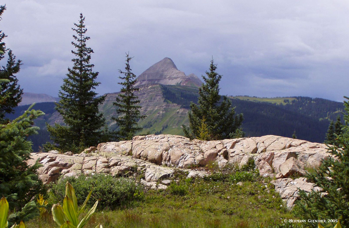
The San Juan Mountains of southwestern Colorado, and parts of northwestern New Mexico, are a sub-range of the Rocky Mountains of North America. There are 653 named mountains in the San Juan Mountains. The highest and most prominent is Uncompahgre Peak at 4,361 meters (14,309 feet). It is also the sixth highest mountain in the entire Rocky Mountain chain. The Colorado expanse of this range of high mountains and plateaus encompasses an area that is roughly 120 miles from west to east and 75 miles from south to north. Contained within this area are some of the highest and most spectacular peaks in the Rockies (including 13 fourteeners). Many will regard this range as the most scenic in all of Colorado and, in fact, the area around the town of Ouray is often referred to as the "Switzerland of America". Just a few miles from this town is one of the truly classic views of the San Juans - the view of the Mount Sneffels Range dominated by its namesake fourteener.
While this area figured prominently in the early years of Colorado's history because of its extensive gold and silver mining industry, today the San Juans are a haven for tourism and recreation. The range is bordered generally on the north and south by U.S. highways 50 and 160 respectively, and on the west and east by State Highway 145 and U.S. Highway 285 respectively; though extending well beyond these boundaries in many areas, these mountains are easily accessed year round. In addition, two all-season highways cross the range from south to north (U.S. 550 and Colorado 149), although heavy winter snow can often close U.S. 550 for periods of time due to significant avalanche danger. Although the range can be crossed east to west by four-wheel drive vehicles on jeep trails in the summer months, there are no roads for ordinary vehicles crossing the range in the east-west direction.
The San Juans straddle the Continental Divide, with the eastern (or Atlantic watershed) slope drained by the Rio Grande river and the western (Pacific watershed) slope drained by the numerous tributaries of three major rivers (San Juan, Dolores and Gunnison) which in turn all flow into the Colorado River. Much of the range is covered by parts or all of four national forests - Uncompahgre, San Juan, Rio Grande and Gunnison - and contains no less than seven wilderness areas. All of this provides a wide range of recreational opportunities including fishing, four-wheeling, hiking, climbing, camping, mountain-biking, skiing (alpine as well as nordic) and who knows what other extreme sports yet to be invented. One could easily spend a lifetime exploring the San Juan mountains without ever getting bored.
And then there is simply amazing tourism - an activity that can be undertaken and enjoyed by almost anybody - and without exerting too much physical energy. Much of what the San Juans offer in the way of tourism today has in fact found its origins in the first major economic driver for Colorado - mining. Perhaps the most famous of all tourist attractions is the 45-mile Durango and Silverton Narrow Gauge Railway. Connecting the two towns through spectacular and almost impossible terrain, this train journey is one of the top tourist attractions in the entire state - and it operates year-round, though on a more limited basis in the winter months. For the road-trippers, the San Juan Skyway is a 200-mile scenic loop drive that encompasses much of the western segment of the range via State Highways 145 and 62, plus U.S. Highways 550 and 160. This drive offers some spectacular views of some of the highest peaks in the Rockies. One can also extend the drive by several hundred miles to circumnavigate virtually the entire range.
Jeeping is a major activity made possible by virtue of the many trails that were built in the 19th century to connected the mining camps, which themselves are worthy of visiting and exploring. One must not take these jeep tours lightly - many of them require considerable four-wheeling experience before one should attempt them. Some also require considerable nerve, such as the Black Bear Road - a one-way-only white-knuckle plunge from the top of Black Bear Pass right into Telluride. The road starts on U.S. Highway 550 at Red Mountain Pass, about halfway between the towns of Ouray and Silverton. Short wheel-base vehicles only - your average 4WD pickup truck might have problems. Experience is mandatory - not just recommended. As one reviewer said - "if you make one wrong move, it's over". This trail is four-wheeling at its ultimate!
There are four ski areas in the San Juans, only one of which, Telluride, has evolved into a major destination resort. It even has the highest airport in the United States with scheduled airline service. Other ski areas are Purgatory, Wolf Creek and Silverton. One might ask why, with the incredible alpine terrain, the San Juans don't have more major ski resorts. There could be several factors. The terrain is incredibly steep so that development on a large scale is limited by relatively narrow valleys. While there is an airport in Telluride, it must be recognized that it can't handle large long-range aircraft. These mountains are a long drive from any large cities, such that the large population base needed to support multiple large resorts simply is not there (think day trips from Denver to the many resorts that can be reached in an hour). Few people will make the drive from Denver to the San Juans for only a two-day weekend.
Because of the immensity and variability of the San Juan Range, it would take an entire book to describe the many hiking opportunities and trailheads to be found in this beautiful part of Colorado. We will attempt to present information about some of the most important areas in this magnificent range and generally how they can be found, without getting bogged down in minute details. Anyone reading this with the intent of using it as a definitive guide to the San Juans is cautioned that they should further inform themselves by choosing a particular region and then focusing on that region and informing themselves by researching either locally or online. There is an abundance of information, guides and maps available as one would expect. But the purpose herein is to simply point the reader to what many consider to be highlights of the San Juans, with an emphasis of informing those visitors to the area who may not know where to start. The abundance of great hiking and climbing venues can be bewildering for first-time visitors. What follows is an overview of some of the best spots based on this writers knowledge of the area and direct experience hiking in this mountain paradise.
Lake City Area - Near the eastern side of the San Juan Range, on Colorado Highway 149 about halfway between the towns of South Fork and Gunnison, is the historic and very charming town of Lake City. Situated in a small and lovely mountain valley, Lake City is an excellent place for staging some very fine hikes, including the climb of five of Colorado's fourteeners. Two of these (Wetterhorn Peak and Uncompahgre Peak, the highest and most prominent in the San Juans as well as the fifth-highest in the Rocky Mountains of North America) are easily accessed from a trailhead just a few miles up the Henson Creek Road - also known as County Road 20. Another major trailhead, the Grizzly Gulch/Silver Creek Trailhead, about 18 miles from town up County Road 30, which follows the Lake Fork of the Gunnison River, provides access to some wonderful hikes to three fourteeners - Sunshine, Redcloud and Handies Peaks - all of which are fairly easy and require no advanced climbing skills. Just stamina. Road 30 is also part of the Alpine Loop, a four-wheel drive route and one of Colorado's Scenic Byways. At the point where County Road 30 becomes a four-wheel drive road, is a stunning valley known as American Basin, which is renowned for it unbelievable array of wildflowers.
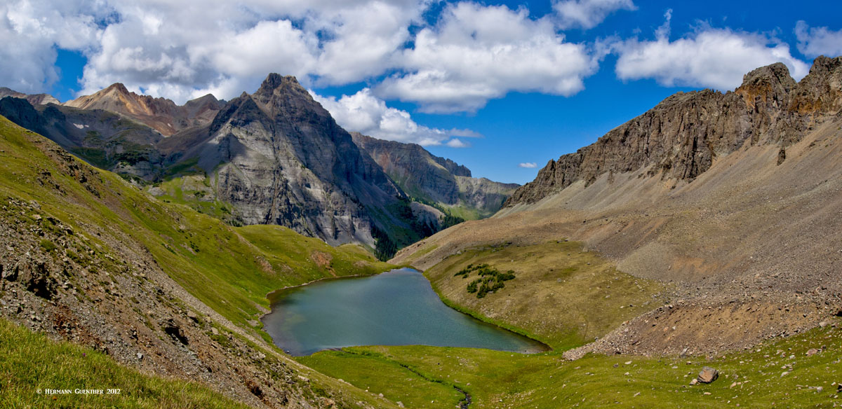
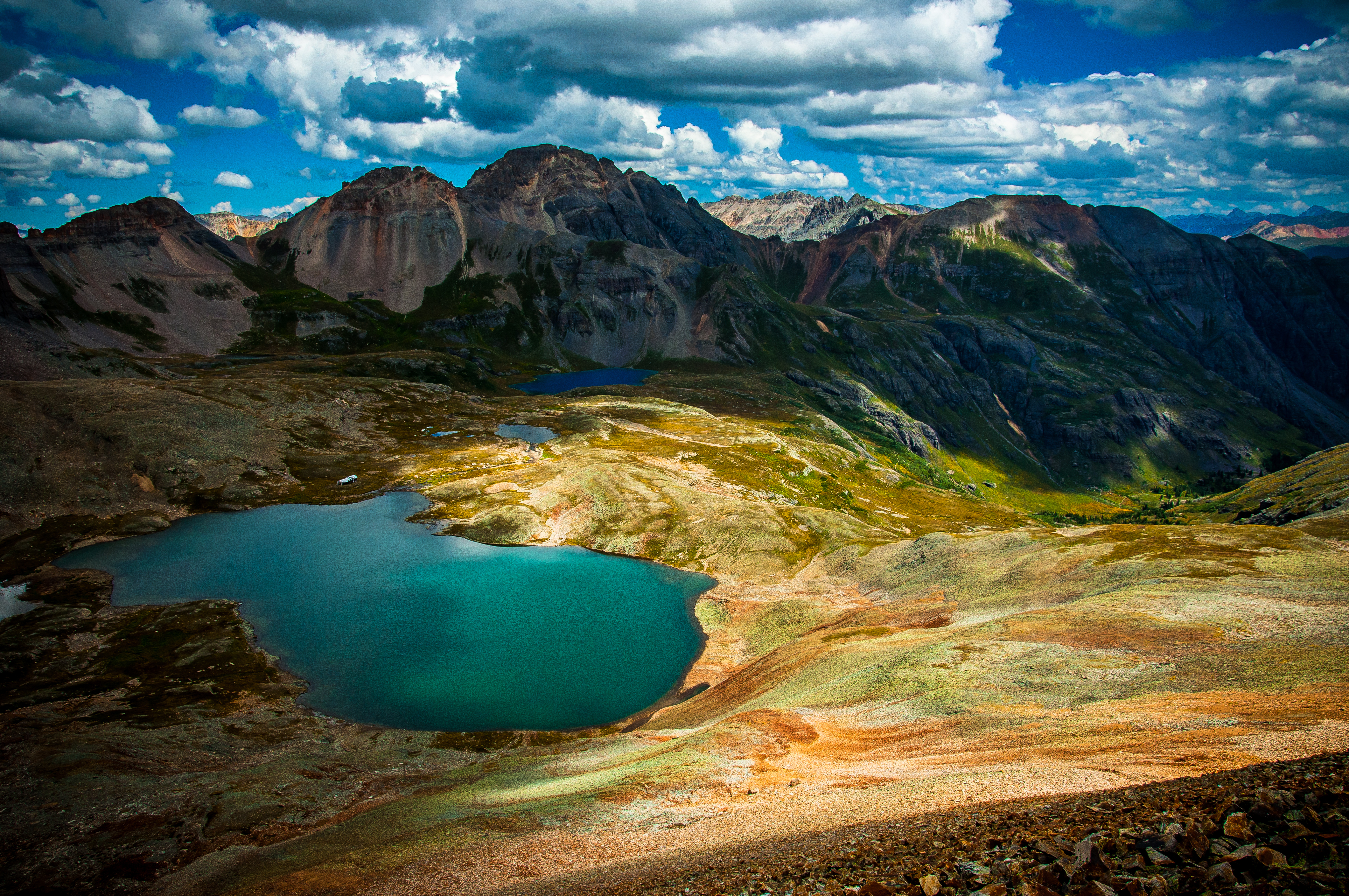
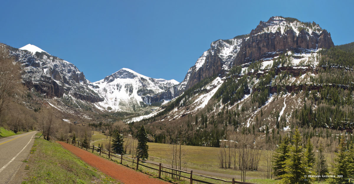
Ouray Area - The alpine terrain around the small resort town of Ouray at the northern fringe of the San Juan Mountains affords countless hiking venues for all levels of experience. A popular fourteener, Mount Sneffels, is only seven miles distant from Ouray but requires a drive of up to 25 miles to reach, including a section of gravel road that is suitable for normal cars - at certain times of year. This gravel road (County Road 7) ends at the popular Blue Lakes Trailhead. The 3.5-mile hike to the Lower Blue Lake is easily one of the most rewarding hikes in Colorado - especially if it is extended to the upper two Blue Lakes, only about one more steep mile of hiking. The view across the lakes basin is second to none. Well, OK, it is just one of many very stunning views in the San Juans. From the upper lake, it is a short but steep climb of 2,400 vertical feet to the summit of Sneffels. Another way to climb Sneffels is via Yankee Boy Basin, which is overwhelmed by wildflowers in summer. Getting to that trailhead from Ouray is only about ten miles but requires a four-wheel drive vehicle with high ground clearance. The climb to the summit is much shorter and requires less elevation gain than from the Blue Lakes Trailhead.
Silverton Area - While there are no fourteeners in the immediate vicinity of this aptly-named and most famous mining town, Silverton affords an excellent base for a variety of spectacular hikes, including plenty of alpine lakes surrounded by an ample supply of thirteeners. Only 24 miles south of Ouray via the iconic Red Mountain Pass on U.S. Highway 550, this town is the northern terminus of the Durango and Silverton Narrow Gauge Railway. Therefore it can be reached by road or train. Only about seven miles west of town is the Ice Lakes Trailhead, adjacent to a campground. This trail leads to a spectacular basin comprising a number of pristine alpine lakes including Ice Lake, the scenic Island Lake, as well as several smaller ones. In mid-summer this hike is renowned for its wildflower displays. Rated moderately difficult due to its steepness and elevation gain, this 3.5-mile trail remains one of the most popular hikes near Silverton. But due to the high elevation, hikers must be aware that afternoon thunderstorms can occur, and escape to lower elevations should be considered.
Chicago Basin - Located about mid-way between Silverton and Durango to the east of U.S. Highway 550 is Chicago Basin in the Needles Mountains. An excellent eight-mile trail leads into the basin, which is surrounded by high peaks including three fourteeners - Mount Eolus, Sunlight Peak and Windom Peak. An unusual quirk about this trailhead is that it is difficult and expensive to reach. No road provides access to Chicago Basin - hikers, climbers and backpackers must use the Durango and Silverton Narrow Gauge Railway to hike into the basin. Upon request, the train will stop at a spot called Needleton from where a short hike takes visitors to the actual Chicago Basin Trail. While this is one of the flagship hikes in the entire state, the disadvantage is the fact that some 100,000 visitors make this hike every year. The presence of so many people stresses the environment and the wildlife - there is a herd of semi-domesticated mountain goats that have a habit of harassing the hikers for food. Nevertheless, this place is iconic and unique in terms of how you get there as well as what you find when you arrive.
Lizard Head Wilderness - While Telluride is better known as the major and only significant destination ski resort in the San Juan Mountains, it is conveniently located for hiking (and climbing) in the westernmost section of the range. The "Wilsons" (Mount Wilson, Wilson Peak and El Diente) are the three fourteeners that dominate the cluster of high peaks to the northwest of Lizard Head Pass on State Highway 145. (A note about El Diente - although it is a named mountain over 14,000 feet, it does not meet the prominence criteria for fourteeners, but is often included on the list because of its challenging ascent route.)
These three fourteeners are the farthest from Denver and are the westernmost fourteeners in the state. They are also some of the most formidable in the state and require plenty of respect. The major trailheads in this area are the Silver Pick, Navajo Lake, Kilpacker and Lizard Head trailheads. They are all accessed from Highway 145 and are approximately 15 road miles from Telluride. Serious climbers would surely be attracted by the imposing spire of the aptly named Lizard Head (13,311 feet) itself.
The San Juan Mountains may be remote from any large metropolitan area, but that does not mean that there is a shortage of visitors to this special region. These mountains attract thousands of tourists from throughout the western states and indeed from other places around the world. The largest town in or on the periphery of this mountain range is Durango, with a population of 18,465 as of 2017. That may not be large but it does have a commercial airport. Although there are no freeways (or motorways) anywhere in the vicinity of the San Juans, there are several good all-season highways that service this region on all sides, two of which even cross the range.
It must be noted, however, that the largest city in western Colorado offers a good alternative to Denver as a major gateway to at least the northernmost fringe of the range. A two-hour drive can bring visitors from the airport in Grand Junction to the resort town of Ouray. But to really get into the heart of the range, travel times can be significantly longer due to the limited highway capacity to handle large amounts of traffic, as well as the distances involved. So, although Grand Junction is a "major" city with a population of 62,475 (2017 estimate) and more widespread airline service, it is not included in the following discussion, although its significance as a gateway city should not be overlooked.
There are a number of well-known towns in the San Juan Range that all provide some levels of tourist infrastructure to various degrees, including some high-end accommodations, even in small towns like Ouray. Of course there are lots of more simple accommodations that are preferable for the many adventurous visitors who have no need or desire for luxury. Simple cabins, cottages and campgrounds abound here. But during the peak summer months, and during the ski season, advance bookings are advised, especially in Telluride and Ouray. Following is a summary of the major (and some minor) towns that provide easy access to the San Juan Mountains, are noteworthy for their historic value, and offer a myriad of activities beyond hiking and mountaineering. We start with the largest - Durango.
Durango is a historic town that was established in 1880 to serve the San Juan mining industry. It was named after a town in Mexico by an ex-governor of Colorado. Sporting a rich history of the development of the "wild west", Durango suffers no shortage of activities for the visitor, in addition to its easy access into the high mountains of the region (Engineer Mountain), which can be found just a short drive north of the city. A major regional airport offers connecting service to major hub airports such as Dallas, Phoenix and Denver. The city has a large selection of accommodations for any budget. Dining options include some truly great restaurants, many with local western ambiance and flavors.
Aside from the many sights and activities, such as local festivals, that can be enjoyed in the city itself, one must not lose sight of what are perhaps the most significant tourist attractions of the southwestern part of Colorado. Mesa Verde National Park, though not established for its scenic splendor, is a UNESCO World Heritage Site that was established in 1906 for its cultural value, depicting Native American life over the millennia. It has over 600 cliff dwellings, including the largest in North America. Mesa Verde is only 35 miles west of Durango. In much closer proximity, in the heart of historic downtown Durango, is the southern terminus of the Durango and Silverton Narrow Gauge Railway. This highly popular attraction will excite just about everyone with an interest in historic rail travel combined with some of the finest scenery in North America.
As a ski town, Telluride is somewhat unique as compared to the more famous glitzy resorts (not to be named here) elsewhere in Colorado. Though it has 5-star accommodations (after all, people fly there in their private jets), Telluride is unpretentious and prefers to maintain its "old west" style. It is simply an old western mining town that grew into one of America's most loved ski towns. Celebrities who prefer to avoid the limelight and attention come here, and even own property. That includes people like Tom Cruise, Oprah Winfrey and Ralph Lauren. But people love it for its amazing setting in the most rugged terrain in the San Juan Mountains. No wonder visitors come here as well for reasons other than skiing. With a permanent population of less than 2,500, the town is not likely to get much bigger - its geology prevents growth and urban sprawl more effectively than does legislation. When not catering to skiing, Telluride offers all kinds of recreational activities - jeeping, golf, fishing, mountain biking, and of course hiking and climbing. And of course this town is also known for its summer music festivals.
While not a major town by any standards, Creede is a very charming town in the San Juans that was a major silver mining boomtown in the late nineteenth century. In a two year span from 1889 to 1891, its population jumped from 600 to 10,000 residents. But mining quickly declined after the "Silver Panic" and the town ceased to maintain a significant mining industry. But Creede did not become a ghost town like so many others even though the population declined significantly. Today it has less than 300 residents. The town does not offer much in the way of tourist infrastructure - the choice of accommodations and dining options is slim indeed, but its small "downtown" is a pleasure to explore and is worth a stop of at least a few hours - more if the visitor wants to take advantage of the first-rate fly fishing in the Rio Grande River and its tributary streams. The headwaters area of the Rio Grande in the nearby Weminuche Wilderness is a favorite for hikers, as is the La Garita Wilderness which is the setting for the easternmost fourteener in the San Juans, San Luis Peak.
Contrary to what its name implies, this is anything but a city. It is a small town, and the seat of Hinsdale County (the third smallest in population in Colorado), with a population of about 400. It is named after nearby Lake San Cristobal, the second largest natural lake in Colorado. As with many mountain towns in the San Juans, Lake City's economic driver shifted from mining to tourism in the early years of the 20th century. Now the town attracts visitors that love to recreate in the mountains and pursue interests such as fly fishing, hiking, jeeping, nordic skiing, climbing and camping. While the town does have a few motels and restaurants, there are a number of cabin and cottage developments as well as campgrounds, that appear to be the preference of visitors planning to stay more than a few days. This wonderful town is not about luxury - it is for people who come here to truly enjoy the pleasures that the mountain environment has to offer. In the winter, much of Lake City shuts down and is left to hard-core outdoors enthusiasts. But it is a great place to base oneself for memorable hiking and mountaineering.
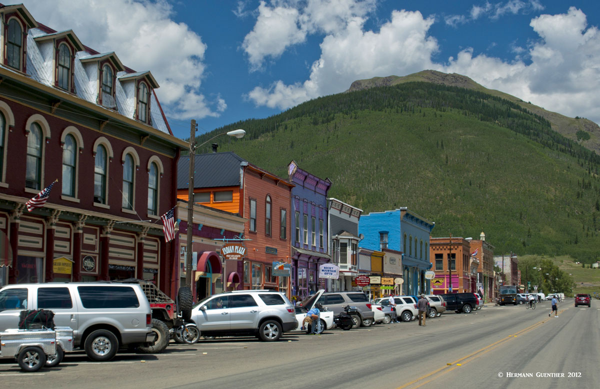
Appropriately named, due to its silver mining history, this little town is tucked right into the middle of the massive San Juan Mountains. It can at times seem completely isolated, especially in the winter when the only access to the town is via U.S. Highway 550, which at times is closed due to heavy snowfall and avalanche danger. Silverton is the seat of, and the only incorporated town in San Juan County, and its 637 inhabitants probably like its apparent isolation - until the tourists arrive. This is the northern terminus of the Durango and Silverton Narrow Gauge Railway, which brings thousands of visitors, although not in the winter. When the train is operating, the town is not quite so remote, and all of these visitors require amenities. Therefore, the town does have a large selection of accommodations and restaurants for those wanting to stay and explore the area. Silverton offers a great number of outdoor activities, summer and winter, too numerous to list here. It is unlikely that anyone would get bored in this idyllic mountain hamlet with its stunning setting.
The pretty town of Ouray (named after a famous Indian Chief) is only 20 miles due west of Lake City as the crow flies - but 136 miles via paved roads. If you have a four-wheel drive vehicle, and at the right time of year, it can be reached from Lake City in only 30 miles via the Alpine Loop and the 12,000-foot Cinnamon Pass. This much shorter route will take longer to complete than that following the paved roads. Ouray and its surroundings are affectionately called the "Switzerland of America" - and for good reason. The scenery from and of the town is simply stunning. Despite its population of just over 1,000 permanent residents, Ouray offers a considerable selection of accommodations and dining options. Aside from being a hiking and climbing mecca, Ouray is famous for its many hot springs, five of which are developed for the tourist trade. On the opposite end of the spectrum, there is an ice climbing park right within the town limits. So there is simply no excuse for not finding something exciting to do in this awesome little gem in the San Juan Mountains.


