
Scan the QR code and open PeakVisor on your phone
Rocky Mountain National Park (RMNP) is located in the north-central part of the U.S. state of Colorado. It is the third most visited national park in the United States and its nearest entrance is only about 75 miles from Denver International Airport. It is located in the Front Range of the Rocky Mountains of North America.
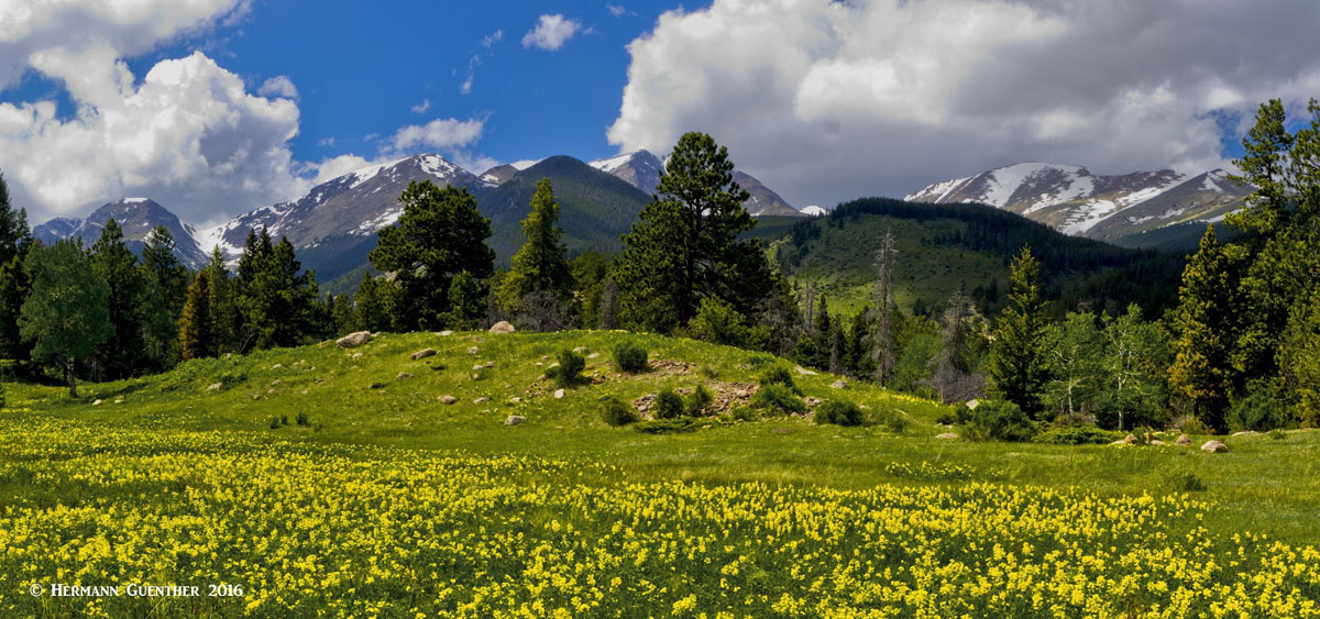
Rocky Mountain National Park in Springtime
It encompasses an area of about 415 square miles. The park is bisected from north to south by the Continental Divide, and varies in elevation from 7,860 to 14,259 feet. This encompasses a number of eco-zones from montane to alpine tundra. It is crossed from east to west by Trail Ridge Road (U.S. Highway 34), which reaches an elevation of 12,183 feet, thus making it the highest continuous paved road in North America. An eleven-mile stretch of the road is above tree line which is at 11,500 feet elevation. But most of the road is usually closed for at least six months of the year due to heavy snow accumulations.
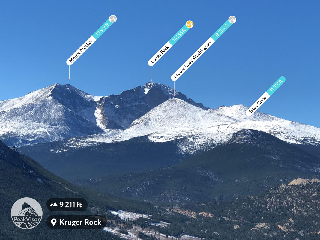
The park has 60 mountain peaks over 12,000 feet, 450 miles of rivers and streams, 350 miles of hiking trails and 150 lakes. The highest and most prominent mountain is Longs Peak, elevation 14,259 feet. It is the only fourteener in the park. Longs Peak is so prominent and dominant that it can be seen from most of the urban corridor, from Denver to Fort Collins, as well as from many miles away to the east as it rises 9,000 feet above the western edge of the Great Plains. This is a climber's mountain, with a number of climbing routes up a sheer cliff known as The Diamond. The "easiest” route up the mountain is the Keyhole Route that is considered non-technical - but only in the summer months.

There are two main vehicle entrances to the park on the eastern side, which is where most visitors enter. On the western side, visitors can enter the park at the town of Grand Lake. The two eastern entrances are in the town of Estes Park. In addition, there are several other vehicle access points to trailheads, but these do not provide vehicular access to other areas of the park. A popular road trip is to drive the 200-mile loop which crosses the Continental Divide twice (once via Trail Ridge Road and once via Berthoud Pass) and provides the visitor with a spectacular diversity of mountain scenery. Within the park there are five visitor centers, one of which, the Alpine Visitor Center, is located near the highest point on Trail Ridge Road and offers spectacular views. It is usually open from late-May until mid-October.
Recreation is of course the major tourist activity and most of that takes place on the eastern side of the park. This is where most of the visitor attractions are - campgrounds, hiking trails, lakes, rivers and streams, and tourist amenities. There are of course such features on the west side but they are fewer, more remote and less accessible by motor vehicle. But the upside is that those wanting a more pristine wilderness experience can find it there. The trails into the interior of the park and the many lakes and mountain peaks are much longer and will in most cases require multiple days and back-country camping.
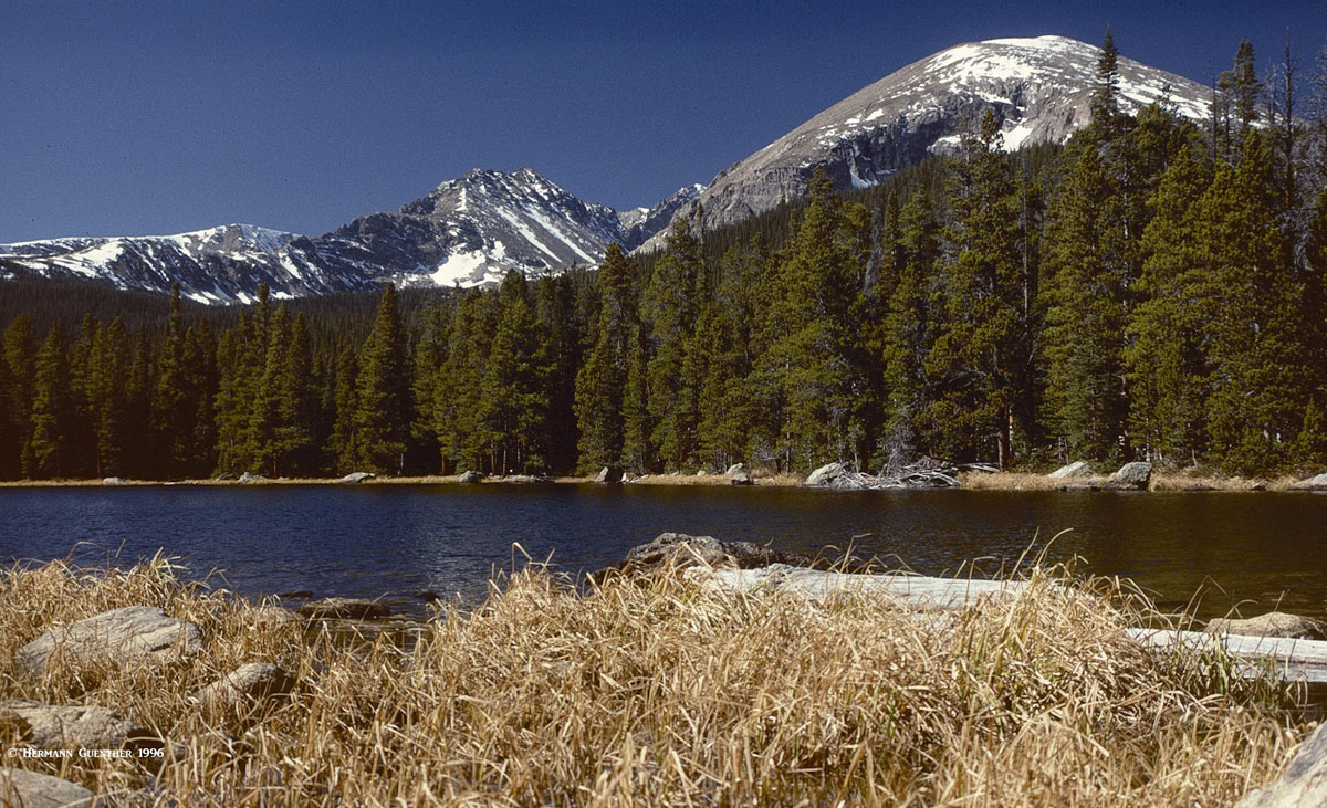
Without question, the biggest attraction in the park is Bear Lake with its iconic views. Though it is possible to drive to the lake on a good road that is usually open all year, the large parking lot is not nearly large enough during the peak summer and early fall season, especially on weekends. It usually fills up early in the morning, after which cars are highly discouraged. To make up for this deficiency, the park offers free shuttle bus service on an almost continuous basis from a large park-and-ride facility partway up the road. This service is well-used and does not deprive the visitor of good options to enjoy the park. It makes regular stops at all of the key attractions along the way. The Bear Lake area is also where some of the finest hiking trails in the park can be found. But these are very popular and the visitor will find no shortage of other visitors.
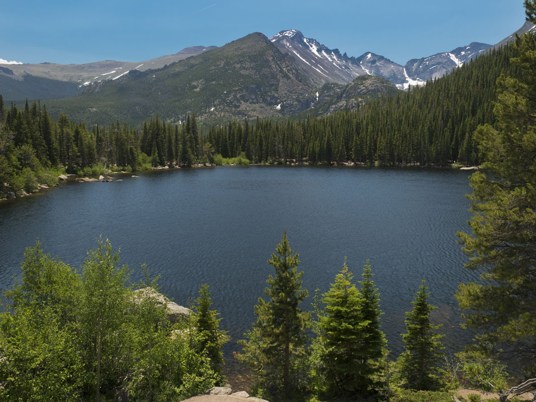
Bear Lake and Longs Peak
Rocky Mountain National Park also offers another seasonal attraction that brings in thousands of visitors each autumn. Elk viewing. The North American Elk (also known as Wapiti) are one of the largest members of the deer family. And there are hundreds of them in the park. During the summer months, large herds can be found in the alpine areas and along Trail Ridge Road. But it is in the autumn that these herds gather in the lower open meadows for the annual rut. This is the mating season and huge males, with their fully grown antlers, will gather their harem which they protect fiercely. This is when the males emit their loud mating calls known as the "bugle" that can be heard over great distances, mostly at dawn and dusk. This is the time when all the visitors descend on the park. It is quite an experience to see and hear these huge animals, often right at the side of the roads, and even on the city streets in Estes Park.

North American Elk
Rocky Mountain National Park is simply one of the finest areas in Colorado to go hiking and climbing. Even people who normally try to avoid areas that are crowded and full of tourists will make exceptions simply to hike the wonderful trails that the park has. There are a number of well-developed trailheads with ample parking (though sometimes not enough during peak periods) and basic amenities such as information signs and rest room facilities. During peak seasons, most of these will even have park rangers posted here in order to help and inform visitors. Most of these trailheads are on the east side of the park. To describe all of the many trailheads in this park is beyond the scope of this discussion. Therefore, only the major ones will be included here, with the understanding that the less popular ones should not be ignored either. This is a national park and just about anything it offers will be worthwhile visiting.

Bear Lake Area - This most popular spot in the park sees a large number of visitors, many of whom simply go to see this gem of a lake, and perhaps take the short and easy walk around the lake, after which they return to their cars or the shuttle bus to be on their way to other sights. But this place is also the starting and/or ending point for some fantastic hikes as well as some classic climbs. Many peaks on the Continental Divide can be climbed from these trails. Aside from the Bear Lake Trail that loops around the lake, the very popular trail to Dream Lake and Emerald Lake, with its iconic views, takes off from here. It is so well used that part of it is even paved.
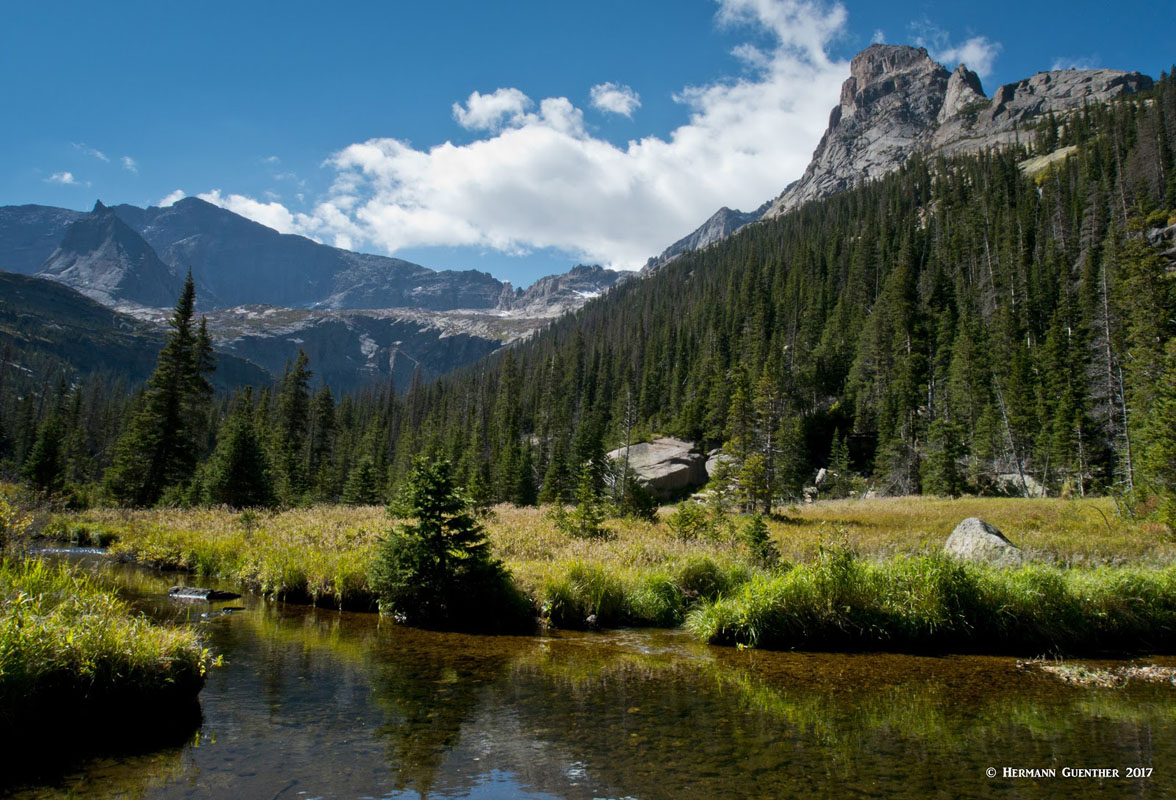
Glacier Gorge
For longer hikes to some spectacular high-country lakes are the trails to Glacier Gorge and Loch Vale. The former leads to Mills and Jewel Lakes which are easily reached by reasonably fit visitors, with the continuation to Black Lake requiring a bit more conditioning. Likewise, the Loch Vale trail leads to the beautiful lake of the same name - The Loch. More adventurous hikers can continue to the Lake of Glass and beyond to Sky Pond, after passing Timberline Falls. Looming above the northwestern shore of Sky Pond is one of the most dramatic views of the entire park - the Cathedral Spires including the Sharkstooth and its adjacent pinnacles which offer some classic climbs. The Petit Grepon is considered one of North America's top 50 climbs.

Sky Pond and Cathedral Spires
A branching trail from the east side of Bear Lake leads to two wonderful hiking options. One is to Flattop Mountain with a short spur to the top of Hallett Peak. The view toward Longs Peak is stunning. Another very popular option is to make the one-way 10-mile hike from Bear Lake to the Fern Lake trailhead in Moraine Park. The first three miles of the Fern Lake Trail follow a gentle uphill slope to a pass that can experience very windy conditions at times, but the views are truly rewarding, especially of Notchtop Mountain straight ahead. After passing Lake Helene, the trail descends for the next seven miles, passing Odessa Lake and Fern Lake. One must be sure to take the short spur trail that backtracks to the north shore of Odessa Lake. The view across the lake toward Notchtop Mountain and the Little Matterhorn is classic and must not be missed. This hike requires a two-car shuttle or better, use of the free park shuttle bus. Whether to park at one end or the other is a matter of choice, taking into consideration that the bus journey requires a change of bus at the park-and-ride facility on the Bear Lake Road. This bus trip can take up to an hour, so for those wanting an early start, parking at Bear Lake might be the preferred choice.
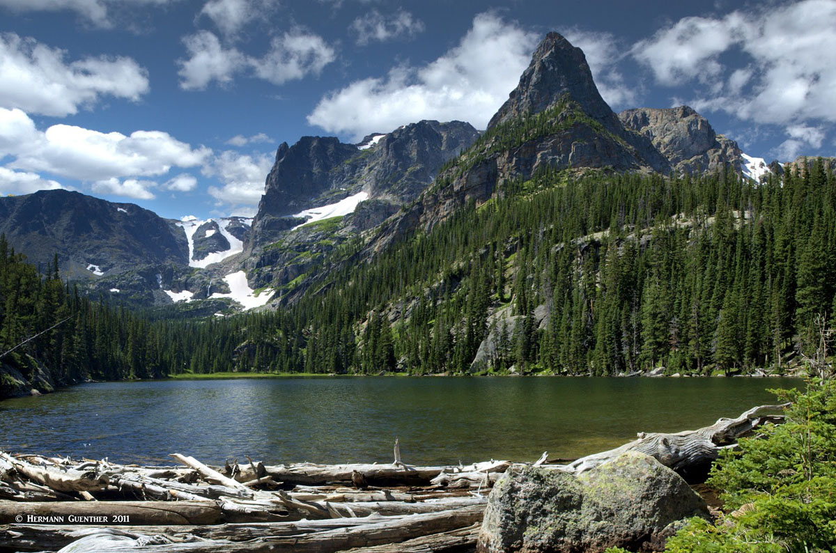
Odessa Lake and Little Matterhorn

3D map of Hallett Peak trail
Bierstadt Lake Trailhead - About halfway up the Bear Lake Road between the large park-and-ride facility and Bear Lake is the trailhead for Bierstadt Lake. There is a small parking lot here but it is more advisable to take the free shuttle bus to this spot. The hike to Bierstadt Lake is easy but the view across the lake toward the high peaks of the Continental Divide is stunning indeed. It is perhaps one of the best views for the small effort required to get there. A bit of advice for anyone doing this hike - be sure to follow the trail that goes around the lake, for it will take you the best viewpoint. On the northeast end of the lake is a small spur trail that goes right to the shore. This is where the best view can be found. It is possible to continue the hike from here to Bear Lake and the many other connecting trails. And it's not necessary to hike back the same way - the shuttle can be taken back down.

Bierstadt Lake and the Continental Divide
Wild Basin Area - About 14 miles south of the town of Estes Park on State Highway 7 is a road that provides access to the Wild Basin trailhead. There is an entrance station along this road as well as a large parking area, and an entrance fee is required here just as in the main parts of the park, from which there is no direct road connection. This trailhead provides access to some of the more remote parts of the park, including a number of alpine lakes as well as waterfalls. The hikes to some of these lakes, including Blue Bird Lake, Thunder Lake, Finch and Pear Lakes, and the Lion Lakes, are lengthy but can be easily done in day hikes for those who are in good condition. An easier hike is the popular destination of Ouzel Falls, about 2.5 miles from the trailhead. Along the way, it takes little additional effort to see the Copeland Falls and the Calypso Cascades.
Wild Basin - Finch Lake
Longs Peak Area - Also reached from Highway 7, but only about 10 miles south of Estes Park is the Longs Peak Road which provides access to the Longs Peak trailhead and campground. This, appropriately, is the main and most popular starting point for climbing Longs Peak, whether it is to climb the mountain by the cliffs of The Diamond or the more traditional non-technical route, known as the Keyhole Route. At eight miles one way with 5,000 feet of elevation gain, the hike to Longs Peak is not for everybody, especially those who are not conditioned or experienced. The faint of heart should avoid this hike - the steep drop-offs and narrow ledges can be daunting. Most people start this hike long before dawn in order to be well off the summit before noon to avoid getting caught in the frequent thunderstorms. A fine day hike to Chasm Lake, at the base of The Diamond, can be made from here as well, as can the relatively short hike to the top of Estes Cone, both of which are to be recommended. Casual hikers are well advised to heed the warning signs regarding the dangers of lighting, which is common above tree line.

Longs Peak Trail
Lily Lake - Seven miles south of Estes Park on Highway 7 visitors can find two trailheads in addition to gentle walking paths around this scenic lake. The Storm Pass Trail is a longer and more strenuous alternative to climbing Estes Cone. It also sees a lot less hikers than the main trail from the Longs Peak trailhead, though the steep climb to the summit is common for both routes. On the opposite side of Highway 7 is the trailhead to the Twin Sisters Peaks. The 8-mile return trail (out and back) leads to the twin peaks which are at about 11,400 feet. The upper reaches of the mountain are above the tree line and afford stunning views in all directions, including far out into the Great Plains. But the view across the valley toward Longs Peak is hard to beat. The Lily Lake area does not require a park entrance fee.

Mount Meeker and Longs Peak from Estes Cone Trail
Western Approaches - There are a number of trailheads on the western side of RMNP, but these are more scattered along U.S. Highway 34 from the town of Grand Lake to Milner Pass, where the highway crosses the Continental Divide. There are also a handful of trails that start at, or cross, Trail Ridge Road. These trailheads provide hiking access into the wilderness and are far from most of the major peaks and lakes which are clustered mostly toward the east side of the park. The trails serviced by these trailheads tend to be very long and are mostly used by long-distance hikers who want to experience multi-day outings far from the congested tourist areas. The popularity of these trails pales in comparison to that of the trails on the east side of the park. Nevertheless, these trailheads deserve mention if for no other reason than informing visitors to the park about their existence and the need for would-be adventurers to inform themselves locally before embarking on a day hike that might find them in the middle of the wilderness, unprepared and not knowing where they are. The most important trailheads include the following:
One would expect the third most visited national park in the country to be surrounded by a number of major towns and resorts. To a small extent that is true in the case of Rocky Mountain National Park. For one thing, some access points to the park are no more than a 90-minute drive from Denver. But most visitors that want to spend several days in the park are not likely to base themselves in Denver, or even in much closer cities such as Boulder or Loveland. They will want to stay much closer so that they can have quicker access to the many venues for sightseeing and recreation that the park offers. Well, there are a few towns that can offer the amenities and tourist infrastructure that these visitors want, the jewel in the crown being the charming resort town of Estes Park. There are a few much smaller towns nearby, such as Allenspark and Lyons, which offer some limited tourist amenities, but are worthy of consideration if solitude and slightly longer driving distances are what some visitors want.
Located right on the doorstep of RMNP and only 75 miles from Denver International Airport, Estes Park is easily the town of choice for most visitors to the Park. With a full-time population of under 6,000, it would seem to be a small town with not much to offer. But that is clearly not what "Estes", as the locals call it, is all about. This vibrant town has it all - a stunning location, a wide selection of recreation activities, plenty of lodging of all kinds, shopping to keep visitors entertained on a rainy day (which doesn't happen much), and a large selection of fine eating establishments. Yet on peak summer days it might be difficult to find a place to stay the night. Perhaps the most famous landmark in town is the Stanley Hotel. Who would not want to spend a night there and read or watch Stephen King's "The Shining"? Preferably on a night of lightning and thunder. This hotel is what gave the author the inspiration to write the book.

The Stanley Hotel
The downtown area of the town is a wonderful place to stroll along Elkhorn Avenue or walk along the side of the Fall River as it flows through town. Many of the restaurants have outdoor seating under the trees by the water. But that is not all there is in "Estes". There is an aerial tramway to the top of Prospect Mountain where the views of the Rockies will not disappoint. Nearby is a winery featuring some fine Colorado vintages; a brewery with restaurant that is never short of customers; an open-air adventure park and a go-cart track; a large RV park for those visitors who want to bring their own housing; and of course the two main entrances to RMNP. There are free shuttle buses and trolleys that take visitors from the outskirts to the center of town, as well as the Hiker Shuttle, and the park's own shuttle service, which allow visitors to leave their cars behind.
Within or close to city limits are campgrounds, horseback riding stables and the beautiful Lake Estes where visitors can enjoy fishing and boating. If all this is not enough to keep visitors happy, then there is of course Rocky Mountain National Park, which, as the third most visited national park in the United States, offers up such an impressive assortment of scenery, trails, rivers, lakes and activities that makes people want to return again and again.
About 20 miles west and slightly south of Estes Park, on the opposite side of RMNP as the crow flies, is a wonderful getaway called Grand Lake, positioned on the shore of the beautiful lake of the same name, Colorado's largest natural lake. It lies near the western entrance to RMNP on U.S. Highway 34. Compared to Estes Park, Grand Lake is a very small town with a permanent population of less than 500. But lest the visitor be fooled by such small numbers, it is known that this charming town can handle its share of visitors, although on a much smaller scale than its eastern neighbor. For those who want to settle down in a more low-key locale, Grand Lake just might be the place, even if it is the western gateway to RMNP. But the park is not the only attractions here. This town offers year-round recreation, and, especially in the winter, it is known as the "Snowmobiling Capital of Colorado".
Grand Lake has an assortment of accommodations, restaurants, bars, shops and galleries. Nearby lodgings can be found that are more rustic in nature, which may be just what many visitors might be looking for when they choose to stay here. For those who are into alpine skiing, the resort of Winter Park is only 35 miles to the south. If Grand Lake (the lake) is not big enough for boating and fishing, there are two much larger lakes right next door - Shadow Mountain Lake and the even larger Lake Granby. The views across these lakes to the high peaks on the other side are simply amazing.

Grand Lake, Colorado


