
Scan the QR code and open PeakVisor on your phone
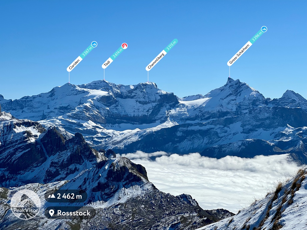
Glarus is home to 364 named mountains. The highest is Tödi at 3,614 m.
Glarus is a canton located in east-central Switzerland. The canton is situated between the Alps to the south and Walensee (Lake Walen) to the north. There are 364 named peaks in the canton of Glarus. The tallest and most prominent peak in Glarus is Tödi at 3,614 m (11,857 ft) in elevation and with 1,570 m (5,151 ft) of prominence.
Glarus (Kanton Glarus) is one of the 26 cantons in Switzerland. The canton covers 685 sq. km (265 sq. miles) of land in central Switzerland, including parts of the northern foothills of the Alps.
The canton of Glarus is surrounded by numerous other cantons. This includes Grisons and Uri
to the south, Schwyz to the west, and St. Gallen to the north and east.
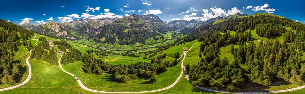
The topography of Glarus is dominated by the deep valleys of the Linth River. The Sernf is a tributary of the Linth River that runs through the Sernftal Valley.
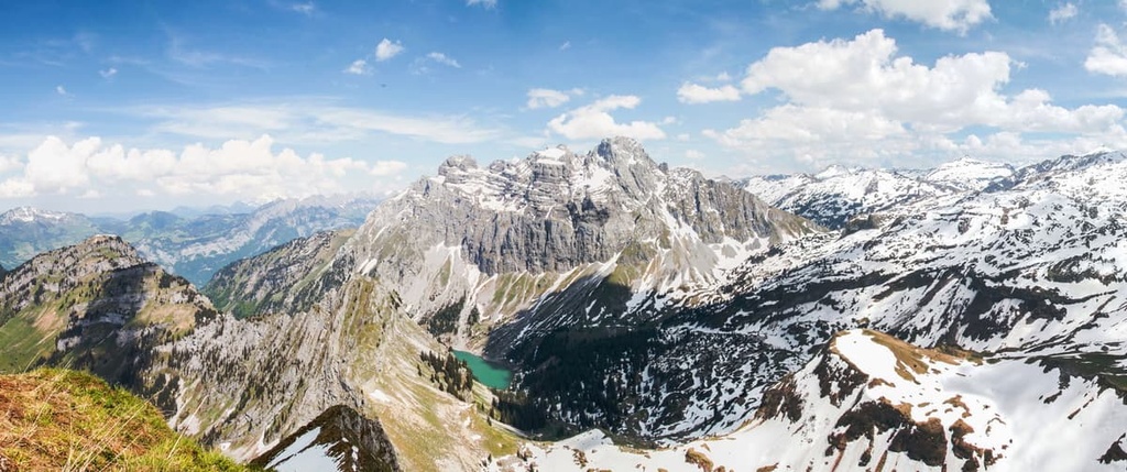
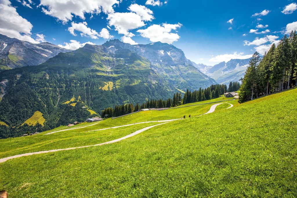
Along with the dramatic valleys, Glarus is dominated by the Glarus Alps, which extend throughout the southern portion of the canton. The varying changes in elevation in the canton allow a variety of ecosystems to flourish in the region.
The lowlands within the valleys of Glarus are home to numerous towns and villages, many of which are primarily agricultural. Dense forests are also common in the canton amidst the steep slopes of the Glarus Alps.
The tallest peak in the canton, Tödi, is also the tallest peak in all of the Glarus Alps. At higher elevations, the landscape is covered by alpine pastures, lakes, and rugged ridgelines.
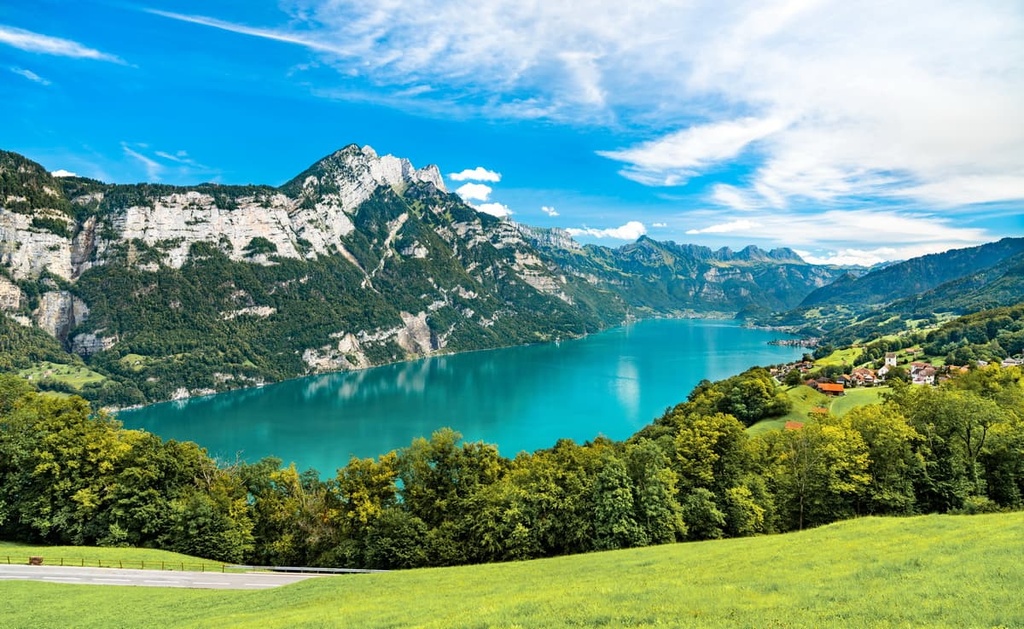
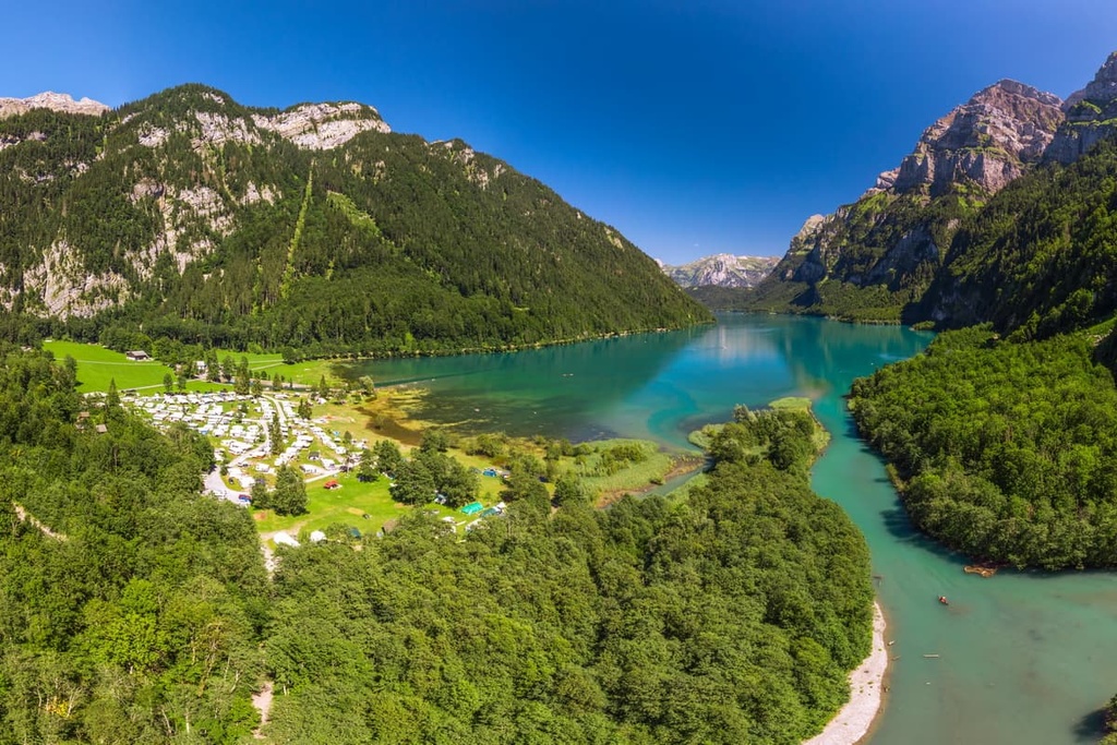
Walensee (Lake Walen), is a large lake that lies along the northern edge of the canton. Klöntalersee is another major lake situated on the canton’s western border.
Additionally, Glarus is located near a number of major protected areas in the country. Parc Ela, Beverin Nature Park, and the Swiss National Park are located to the southeast of Glarus while UNESCO Biosphere Entlebuch is situated to the west and Binntal Nature Park is located to the southwest.
The Glarus Alps cover much of the southern and eastern portions of the canton. This subrange of the Alps is bordered by the Uri Alps and Schwyz Alps to the west, the Appenzell Alps to the northeast, and the Lepontine Alps to the south. The Glarus Alps also extend into the nearby cantons of St. Gallen, Grisons, and Uri.
As a whole, the Alps began forming around 65 million years ago, during the Alpine orogeny. This mountain building event also created the Pyrenees, Himalaya, Karakoram, Caucus, Atlas, Carpathians, and the Hindu Kush.
The Tethys Ocean once lay between the supercontinents of Gondwana and Laurasia, or present day Africa and Europe.
As these two tectonic plates collided with one another, the ocean retreated, leaving behind large quantities of marine sediment. This collision led to immense pressure and recumbent fold that would go on to form the Alps.
Over the course of millions of years, continual folding transformed the once shallow seafloor into the rugged peaks that can be seen within the canton today. The Swiss Plateau, which is located to the northwest of the canton, was slowly thrust upward during this time as well.
The peaks within the canton consist primarily of sandstone and limestone. These rather brittle rocks are what have allowed the range to be formed into the distinct and jagged peaks that dominate the region to this day.
During the last glacial maximum, much of the region was heavily glaciated. As temperatures began to rise, glacial melt and retreat further carved out the sweeping valleys and peaks that define the region. Major glaciers found within the canton include Limmern Glacier, Biferten Glacier, and Vorab Glacier, the latter of which lies partially in Grisons.
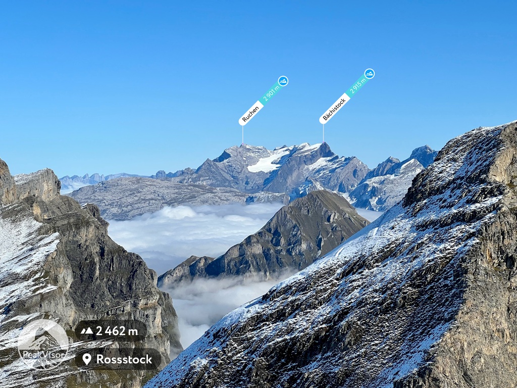
Major peaks within Glarus include Tödi, Bächistock, Redertenstock, Hausstock, Piz Segnas, and Ruchen.
Glarus is home to a variety of ecosystems because it contains such a wide array of landscapes, including everything from the shores of Walensee,up to the summit of its tallest peaks. That said, many of the meadows found near towns and villages in Glarus are used for farming and agriculture purposes.
Common tree species found in the canton include silver fir, European beech, and sycamore maple. At lower elevations in the canton, there are large populations of Norway spruce, tilia, and oak.
The alpine fields in the region provide the ideal habitat for a variety of wildflowers to flourish. Common species include great horsetail, fragrant orchid, common heather, willow gentian, silver thistle, and germander speedwell.
Mammals can be found throughout the canton and the most common species are northern chamois, northern chamois, western roe deer, ibex, and European fallow deer. In the forested regions of the canton, there are populations of brown hare, wild boar, common hedgehog, and red fox. The rock fields and streams in the canton are home to marmot, stone marten, and Eurasian beaver.
The lakes in the region are full of brown trout, European perch, and chub. Multiple species of both birds and bats live within Glarus. Some of these species include coal tit, great egret, golden eagle, black redstart, and Eurasian sparrowhawk.
The earliest signs of human settlement near Glarus date back to 12,500 BCE. During both the Neolithic and Bronze ages, larger settlements began forming near the major lakes of the region.
During the sixth century CE the inhabitants of Glarus were converted to Christianity by an Irish monk known as Saint Firdolin who founded Säckingen Abbey.
The Alemanni people began settling in the valley during the eighth century CE. By the eleventh century CE, the Alemannic German language became the dominant language of the region. From the ninth century CE, Glarus was ruled by Säckingen Abbey and the town of Glarus was referred to as Clarona.
In 1288, the Habsburgs claimed the abbey’s rights and owned much of the surrounding region. In 1352, Glarus became one of the eight cantons to join the Old Swiss Confederacy. Not long afterward, in 1388, the Habsburgs attempted to reclaim the valley in what would be known as the Battle of Näfels.
During this battle, the people of Glarus used banners with Saint Fridolin on them, an image that is still part of the canton’s flag and coat of arms. In order to maintain peace between the Catholics and Protestants of the region, the canton provided each group with their own assembly.
From 1798 to 1803, the canton was part of the Helvetic Republic under the rule of Napoleon. By 1836, the canton had adapted its constitution to unite the region under one assembly.
During the mid-nineteenth century, the canton struggled to grow crops, forcing many residents into deep poverty. Many people throughout the canton emigrated to the United States and founded the town of New Glarus, which is located in the state of Wisconsin.
In 2007, Glarus became the first canton in the country to lower the voting age to 16. Today, the canton’s major lake, Klöntalersee, helps produce electricity, which is one of the canton’s main exports.
Glarus is home to numerous trails for hiking and outdoor recreation. Here are some of the most popular trails in the canton:
The Klöntalersee Trail is arguably the most popular hiking route in the canton. This loop trail travels around Klöntalersee, offering stunning views of both the lake and the surrounding peaks.
The trail is 12.5 km (7.8 miles) long round trip with 528 m (1,732 ft) of elevation gain. The route can be accessed throughout the year. It is also a particularly good place for bird and wildlife viewing.
The route to the summit of Hirzli is 6 km (3.8 miles) round trip with 618 m (2,027 ft) of elevation gain. The trail begins near the town of Bodenberg and climbs steeply through the dense forested hillsides of the region.
Once at the summit, hikers are rewarded with panoramic views of the valleys within Glarus, and Walensee to the east. During the summer months, wildflowers can be spotted throughout the route.
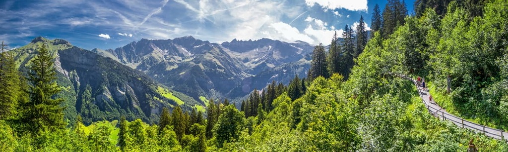
Elm - Ämpächli - Chüebodensee - Wildmadfurggeli is a loop trail situated in the southern portion of the canton. The route is 11.7 km (7.3 miles) long with 882 m (2,893 ft) of elevation gain.
From the town of Elm, hikers can take a gondola to Ämpächli to begin this route. From there, the trail travels through the lush alpine terrain, passing various streams and small alpine lakes. The jagged peaks of the Glarus Alps can be seen throughout the entirety of the trail.
For skiing and snowboarding enthusiasts, there are more than 5 ski resorts in Glarus, which are located throughout the canton.
The two and only large ski resorts in Glarus are Elm im Sernftal with more than 40 km (25 mi) of slopes and more than 5 ski lifts and Braunwald with more than 30 (19 mi) of slopes and more than 10 ski lifts. These are also the main ski resorts near Glarus, its namesake capital.
Check the Glarus ski resorts map as well as the larger Switzerland ski resorts map in the World Mountain Lifts section of the site. It includes information about open ski lifts / slopes in Glarus in real-time with opening dates and hours. There are also year-round cable cars, funiculars, cog railways, aerial tramways, and all other types of mountain lifts.
Looking for a place to stay in Glarus? Here are some of the best cities and villages to check out in the region:
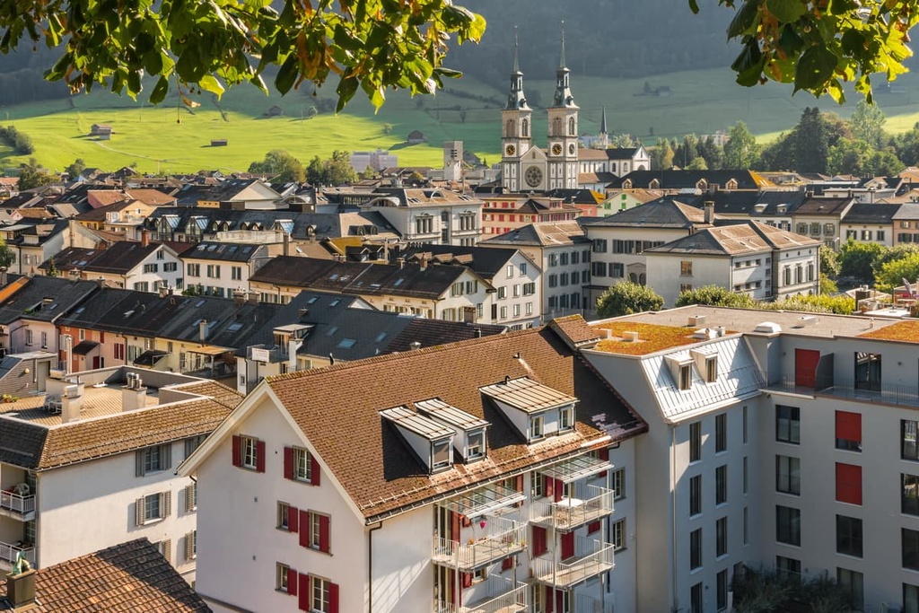
Glarus is the capital of its namesake canton. With a population of 12,500, Glarus is the smallest canton capital in the country. The city lies on the river Linth in between the Glarus Alps to the east and Glärnisch massif to the west. The city gained recognition during the nineteenth century for its printed fabrics.
Nearby peaks provide the ideal location of snowshoeing, skiing, and tobogganing during the winter months. Throughout the summer, the nearby region of Klöntal provides ample opportunities for hiking. Cyclists visiting the region can also explore the 50 km (31 mile) long Industrial Trail that travels around Glarus.
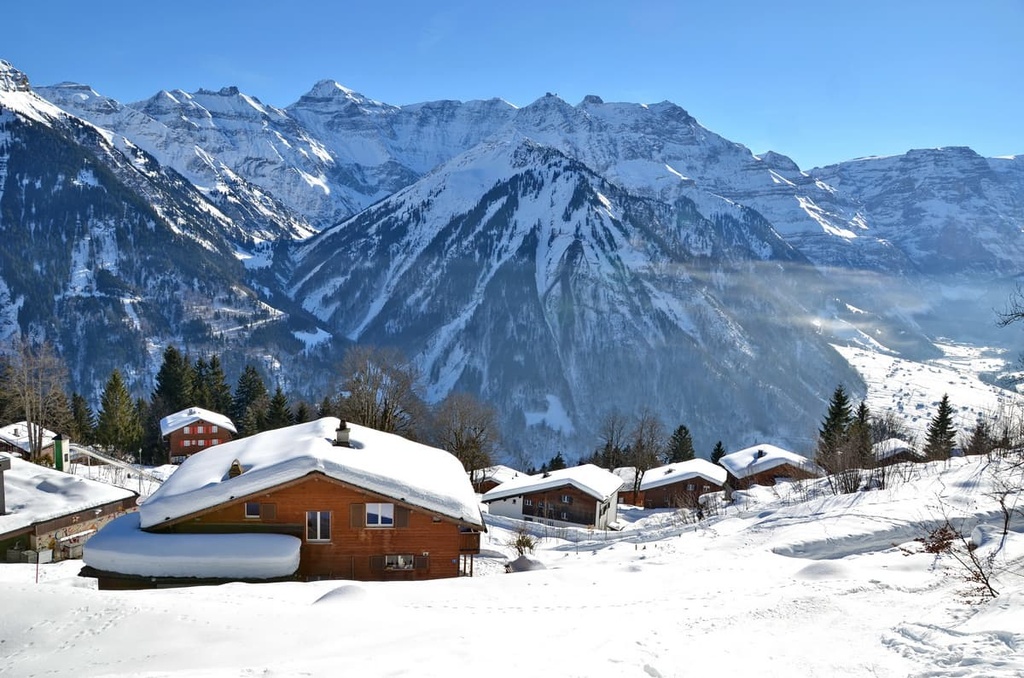
Braunwald is a car-free town situated in the southwestern region of the canton. The town has a population of just over 300 people and is home to the largest ski resort in Glarus, the Ski Resort Brunwald. The Braunwald funicular connects visitors to the resort from the nearby village of Linthal.
Situated high above the valley floor, Braunwald provides year round views of the surrounding glaciated peaks. During the winter months, the town comes alive as it becomes a haven for skiing and snowshoeing. During the summer, the resort transforms into an ideal destination for both hikers and mountain bikers. The Märchenhotel, or Fairy-Tale Hotel, is also located within the town and is known for being one of the best hotels in the region.


Yes. Glarus has 364 named mountains. The highest is Tödi at 3,614 m.
The highest mountain in Glarus is Tödi, at 3,614 m.
Glarus has 364 named mountains.


