
Curated by Frabosa
Frabosa Soprana
Mondovì-side village below the Mondolè ski slopes, with the Bossea cave and its underground river nearby.
- 1Highlights
- 9Routes
- Featured summit · Serra del Pick
Highlights
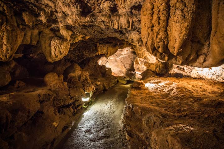
Le Grotte di Bossea
A show cave in the Corsaglia valley with an underground river and the skeleton of a cave bear.
Nothing of this kind in Frabosa Soprana.
Routes
4 from neighbouring places
Sentiero n°6
A short marked path above Frabosa Soprana to the Rocca Davì, in the Mondolè hills.
- 3.7 km
- Distance
- 158 m
- Ascent
- 1 h 22 min
- Duration
- 1
- Check-ins
Sentiero n°5
A long marked route above Frabosa Soprana over the Serra del Pick and the Cima Ciandre, under the rocks of the Dente.
- 12.8 km
- Distance
- 740 m
- Ascent
- 5 h 14 min
- Duration
- 6
- Check-ins
Sentiero n°2
A short waymarked path above Frabosa Soprana in the Val Maudagna, on pasture and woodland tracks.
- 3.4 km
- Distance
- 197 m
- Ascent
- 1 h 34 min
- Duration
Sentiero n°1
The waymarked climb from Frabosa Soprana to the Cima Ciandre, on the ridge dividing the Maudagna and Corsaglia valleys.
- 8.0 km
- Distance
- 575 m
- Ascent
- 3 h 48 min
- Duration
- 1
- Check-ins
Sentiero n°4
A short level link between the hamlets of Frabosa Soprana, usable as a connection between the longer local paths.
- 1.3 km
- Distance
- 30 m
- Ascent
- 29 min
- Duration
Sentiero n°9
A marked path above Frabosa Soprana to the open top of Monte Pelato, on the grass ridges of the Monregalese.
- 5.6 km
- Distance
- 384 m
- Ascent
- 2 h 33 min
- Duration
Sentiero n°7
An easy waymarked route on the pastures and lanes above Frabosa Soprana, between the village and the higher meadows.
- 6.0 km
- Distance
- 321 m
- Ascent
- 2 h 18 min
- Duration
Sentiero n°E24
A signed traverse on the slopes around Frabosa Soprana, linking hamlets and meadow tracks at mid height.
- 7.7 km
- Distance
- 233 m
- Ascent
- 2 h 36 min
- Duration
Sentiero n°8
A flat short path at Frabosa Soprana, useful as a village-level walk or as a link to the longer numbered routes.
- 1.6 km
- Distance
- 4 m
- Ascent
- 33 min
- Duration
AVU Tappa 2: Rifugio Mondovì
10 km away, in Roccaforte Mondovì
A long stage in the Maritime Alps ending at the Rifugio Mondovì, in the Ellero valley above Roccaforte Mondovì.
- 14.5 km
- Distance
- 2 170 m
- Ascent
- 12 h 31 min
- Duration
- 59
- Check-ins
AVU Tappa 2A: Tetti delle Donzelle
13.2 km away, in Briga Alta
A steep stage in the mountains of Briga Alta, crossing the Colla di Carnino saddle to reach Rifugio Mongioie.
- 4.1 km
- Distance
- 1 590 m
- Ascent
- 8 h 24 min
- Duration
- 14
- Check-ins
AVU Tappa 1: Pian delle Gorre
13.7 km away, in Chiusa di Pesio
A demanding first stage from the Rifugio Pian delle Gorre past the Mondovì and Garelli refuges, over the Porta Sestrera and Porta Biecai.
- 12.0 km
- Distance
- 2 230 m
- Ascent
- 12 h 31 min
- Duration
- 69
- Check-ins
AVU Tappa 1A: Pian delle Gorre
13.7 km away, in Chiusa di Pesio
A short valley walk above Chiusa di Pesio, passing the Cascata del Saut waterfall on the way up to the valley-head refuge.
- 4.5 km
- Distance
- 1 850 m
- Ascent
- 9 h 45 min
- Duration
- 22
- Check-ins


No routes of this kind in Frabosa Soprana yet.
The region's own picks

Featured route
Sentiero n°6
A short marked path above Frabosa Soprana to the Rocca Davì, in the Mondolè hills.
Planning a trip to Frabosa Soprana?
Everything else Piedmont has, in one place


Take Frabosa Soprana with you into the mountains
Every route on this page with 3D terrain, GPX navigation and offline maps — including the valleys with no signal.
Data sources
- Official website: visitcuneese.it ↗
- Routes and highlights: Frabosa, Piemonte Outdoor, Bookingpiemonte
- Published as open data by the tourist boards named above.
- Region summary generated from the board's own material.
