
Scan the QR code and open PeakVisor on your phone
A land of towering mountainscapes and rich culture, Bhutan is a small, landlocked country situated in the heart of south-central Asia. The country contains 45 named mountains, the highest and most prominent of which is Gangkhar Puensum (7,570 m/24,836 ft).
The country of Bhutan (officially the Kingdom of Bhutan/འབྲུག་རྒྱལ་ཁབ་/Druk Gyal Khap) is a small nation located in south-central Asia.
With a total area of 38,394 square kilometers (14,824 square miles), Bhutan is the 133rd largest country on the planet after Estonia, Denmark, Netherlands, and Switzerland. However, it is just the 162nd most densely populated country in the world as of 2021.
Bhutan’s location within the heart of south-central Asia means that it is completely landlocked. Indeed, the country is situated along the easternmost edge of the mighty Himalaya, which is the world’ largest mountain chain. This means that it is located more than 500 km (300 mi) from the nearest ocean.
Furthermore, despite being landlocked, Bhutan only shares its borders with two other countries—China (Tibet) to the north and India (states of Assam, Arunachal Pradesh, West Bengal, and Sikkim) to the south. That being said, Bhutan is located very close to both Nepal to the west and Bangladesh to the south, even if they don’t actually share a land border.

Bhutan is officially divided up into 20 districts (dzongkhags), which are the country’s primary subdivisions. Each district has its own local government, court system, and representatives in the federal government. These districts can be further organized into zones (dzongdeys), which were established in the 1980s.
Bhutan’s Zone 1 contains all of its western districts, including Samtse, Haa, Chukha, Paro, and Thumbu. Meanwhile, Zone 2 includes the west-central districts in the country, such as Gasa, Punakha, Wangdue Phodrang, Dagana, and Tsirang.
Zone 3 of Bhutan contains the country’s east-central districts of Bumthang, Trongsa, Sarpang, and Zhemgang. Finally, Zone 4 encompasses the easternmost districts of the country, such as Lhuntse, Mongar, Pemagatshel, Samdrup Jongkhar, Trashigang, and Trashiyangtse.

Despite being a relatively small country, Bhutan does contain a surprising number of national parks, wildlife sanctuaries, and other similarly important protected areas. In fact, more than 51% of Bhutan's total land area is protected, which is the highest percentage of protected land of any country in Asia.
Indeed, Bhutan demonstrates a strong commitment to conservation, particularly when it comes to setting aside large parcels of land for wildlife habitat. In particular, the country contains a handful of large national parks, such as:

Furthermore, there are a number of important wildlife sanctuaries, nature reserves, and preserves in Bhutan, including:

It’s also worth mentioning that the country sets aside land as part of a number of biological corridors that connect Bhutan’s protected areas. These biological corridors were established as part of a “Gift to the Earth,” in order to allow wildlife to travel between major protected areas and to prevent habitat fragmentation.
The country of Bhutan is located in the easternmost part of the Himalaya—the world’s highest mountain range. While the country does not contain any 8,000-meter (26,246 ft) peaks, it does contain a handful of 7,000-meter (22,965 ft) and many 6,000-meter (19,685 ft) mountains.
That being said, Bhutan’s geology isn’t as well understood as that of its neighbors due to the relatively little mapping and research that’s been done in this region when compared to places like India and Nepal.
Nevertheless, Bhutan is home to some exceptionally old rocks, including parts of the Indian Shield, which dates back some 3.5 billion years.
The dominant geologic feature of Bhutan, however, is the country’s towering Himalyan Peaks. In fact, Bhutan is home to the world’s highest unclimbed mountain—Gangkhar Puensum (གངས་དཀར་སྤུན་གསུམ).
Gangkhar Puensum is the tallest peak in Bhutan but it has never been climbed. A number of expeditions attempted to climb Gangkhar Puensum in the 1980s, but they all failed to reach the summit.
Furthermore, since 1994, all peaks in the country with elevations over 6,000 meters (19,685 ft) have been off-limits to climbers, and since 2003, all mountaineering has been banned in the country out of respect for the many communities in Bhutan that place high spiritual importance on the mountains themselves.

Therefore, it is expected that Gangkhar Puensum will retain its status as the highest unclimbed peak in the world for the foreseeable future.
Bhutan is often considered to be an ecological gem thanks to its stunning natural landscapes and fantastic diversity of flora and fauna.
Due to the country’s location in the eastern part of the Himalaya, much of Bhutan is hilly or mountainous. This large difference in elevations provides for a superb range of different ecosystems within the country.
In the lowest elevation parts of the country, Bhutan contains a diversity of habitats, including marshes, wetlands, and forests. Meanwhile, the mid-elevation locations in the country contain mostly coniferous forests that eventually transition into alpine meadows above the treeline.
As far as wildlife goes, Bhutan is a haven for many of south-central Asia’s most iconic species.
The country is home to a range of species that includes the Eurasian lynx, jungle cat, clouded leopard, leopard cat, Indian leopard, snow leopard, and the Bengal tiger, the latter of which is one of the world’s largest extant big cats. Other notable animal species in Bhutan include the dhole, red panda, sloth bear, Asiatic black bear, and the Indian rhinoceros.

Thankfully, a large portion of Bhutan’s natural landscapes have been preserved as either national parks, wildlife sanctuaries, or nature reserves. Indeed, Bhutan’s government and its societal values place a large emphasis on caring for and protecting our natural environment.
Of course, the country does face a number of environmental challenges, including pollution and land degradation. The country also has a relatively high rate of wood consumption for fuel, which has caused some issues pertaining to deforestation.
Nevertheless, the county is thought to be the world’s only carbon-negative country, a title it holds due to its strong commitment to environmentalism.

The land that is now part of the Kingdom of Bhutan has been inhabited by humans for thousands of years. However, the introduction of Buddhism to the region in the seventh century CE is often considered to be a starting point for formal Bhutanese history.
Early Bhutanese history is not well understood as many of the region’s historical records have been lost over time.
It is generally recognized that the unified geographical entity that is Bhutan came into existence during the seventeenth century when Ngawang Namgyal, a military leader, unified the many fiefdoms that had existed in the region. Namgyal helped direct the construction of a large network of dzongs (fortresses) and he helped to establish a centralized government.
Around this time, two Jesuit ministers from Portugal, Estêvão Cacella and João Cabral visited Bhutan, making what was likely the first-ever visit of Europeans to what is now Bhutan.
Not long afterward, Bhutan entered into a period of conflict with some of its neighbors, which led to intervention by the British East Indian Company. However, the British engaged in minor battles with the Bhutanese forces throughout the eighteenth century until the Treaty of Sinchula was signed, ending hostilities between the two nations.

After a period of civil war, Ugyen Wangchuck was chosen to be the hereditary king (Druk Gyalpo) of Bhutan in 1907. This act is generally regarded as one of the most influential moments in Bhutan’s recent history as it established a constitutional monarchy that exists to this day.
For many years, Bhutan was relatively secluded from the outside world. However, with the construction of Paro Airport, the country finally had another means of arrival other than its limited land-based ports of entry.
While Bhutan is still somewhat isolated due to its inbound visa and travel restrictions (Bhutanese citizens are free to travel outside of the country), the country has made a major push toward increasing tourism within its borders.
However, the country’s tourism requirements, such as the fact that all non-Bangladeshi, Indian, and Madavian citizens must book a trip with a registered tour operator, means that it is not a budget-friendly option when compared to other nearby nations in south-central Asia.

Nevertheless, the rich, beautiful, and unique cultural heritage of Bhutan, as well as the country’s stunning natural landscapes, makes it a superb destination for the more adventurous among us.
With so many stunning protected areas to choose from, there’s no shortage of hiking and trekking opportunities in Bhutan. However, it’s worth noting that some of Bhutan’s protected areas are off-limits to the public in order to preserve the environment for wildlife.
Despite this, there are plenty of great trekking routes to choose from in the country. Here are some of the best protected areas to visit in Bhutan:
Considered to be the crown jewel of Bhutanese trekking, the Snowman Trek is a 27 day trekking route that’s often considered to be the world’s hardest trek. Technically speaking, the Snowman Trek is an extended version of the Laya Gasa Trek, so you can scale this adventure to suit your skills and interests.
On this trek, you’ll venture deep into the Bhutanese Himalaya and through beautiful natural landscapes. Indeed, you’ll be in one of the most remote parts of the country so there are few towns and settlements along the route. So, this is a great option for the more experienced trekkers among us.

A superb 6 day trek, the Dagala Thousand Lakes Trek takes you through lush forests of rhododendron and into alpine meadows. To start this trek, you’ll venture out from the town of Tsheregang and head into the mountains to the north.
Eventually, you’ll make your way into the mountains where views of Kanchenjunga in India and Nepal await. If the weather is good and you get lucky, it is also sometimes possible to see Mount Everest in the far distance on this trek.

Although the vast majority of international travelers to Bhutan need to book their stay with a registered tour operator (more on that in a bit), chances are pretty high that your trip to the country will take you to one of Bhutan’s largest cities. Here are some of the largest cities in the country to check out on your next visit:
The capital and largest city in Bhutan, Thimphu (ཐིམ་ཕུ) is a community of some 115,000 people located in the west-central part of the country.
Thimphu is also located up to 2,648 meters (8,688 feet) in elevation, which makes it the fifth highest capital city in the world after the capitals of Bolivia, Ecuador, Colombia, and Ethiopia. However, it is just slightly higher in elevation than the capital cities of Eritrea, Yemen, and Mexico.
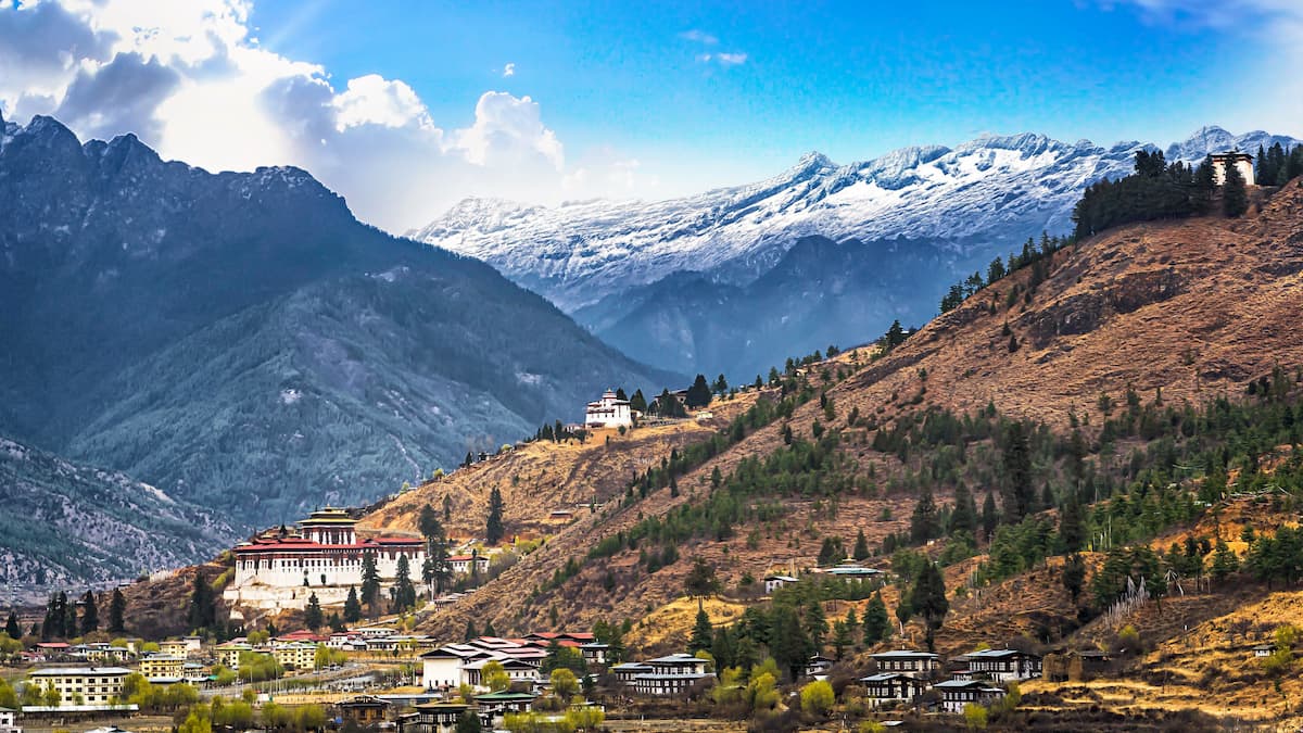
The city is the commercial and cultural hub of Bhutan and it is a starting point for most international travelers to the country. However, Thimphu is one of the world’s only capital cities without an airport as the airport at Paro is some 52 kilometers (32 miles) away.
The second-largest city in Bhutan, Phuntsholing (ཕུན་ཚོགས་གླིང་) is a metropolitan area located in the southwestern part of the country along the border with India. Phuntsholing is home to about 30,000 people.
Due to the city’s location in southern Bhutan, it has a subtropical climate with warm weather and plentiful rain from May to September of each year. Phuntsholing is also one of Bhutan’s main ports of entry as much of the country’s international trade with India comes through the city’s border crossing.

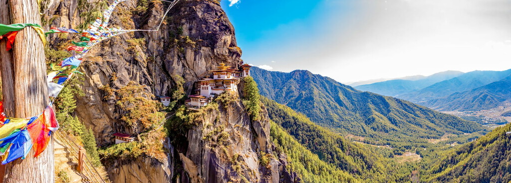
Located just outside of the city of Thimphu, the town of Paro (སྤ་རོ་) is a popular starting point for many visitors to Bhutan. Indeed, although it has only 12,000 residents, Paro is home to the only international airport in the entire country, so many travelers from outside India or Bangladesh fly into Paro Airport.
Paro is also known for its spectacular architecture. The country contains a large number of traditionally-desciend buildings as well as some famous monasteries.

The town of Gelephu is located in south-central Bhutan along the country’s border with India. It is home to about 10,000 residents and it is one of the country’s main land-based border crossings.
Gelephu is quickly developing into one of southern Bhutan’s main commercial hubs. Due to the relatively flat land in the town, it has become an important center for trade, particularly with India. Furthermore, the town has a new airport (Gelephu Airport), though it has not yet opened for operations.

If you’re interested in traveling to Bhutan, there are quite a few things you ought to know before you book your trip. While travel requirements can change at any time (check with the Tourism Council of Bhutan for the latest updates), as of the time of writing, all tourists other than those traveling on Maldivian, Bangladeshi, and Indian passports, must obtain a visa prior to arrival in order to enter the country.
Furthermore, anyone other than people of Indian, Bangladeshi, and Maldivian nationality must book their trip to Bhutan through a recognized Bhutanese tour company or one of these companies’ international partners.
It’s also worth mentioning that all tourists to the country have to pay a minimum daily package fee, which includes the cost of food, 3 star accommodation, an experienced guide, and transportation within Bhutan.
Although you may pay more than this minimum fee for upgraded accommodation or other similar additions to your trip, this minimum daily package rate is set by the Bhutanese government and part of it goes to a sustainable development fee.
As a result of these requirements, traveling to Bhutan at the last minute is usually not possible. Therefore, anyone looking to go to the country is highly encouraged to plan their trip well in advance to ensure that there’s plenty of time to deal with any potential visa issues.
Finally, it’s important to remember that tipping (gratuities) is highly recommended in Bhutan, especially for drivers and other people who work in the service industry.
We should also mention that dressing modestly while at monasteries, temples, Dzongs is expected for all visitors. However, your tour guide will help you learn more about the local rules, regulations, and customs during your stay.


