Scan the QR code and open PeakVisor on your phone
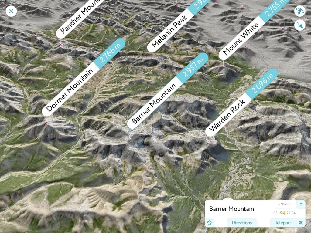
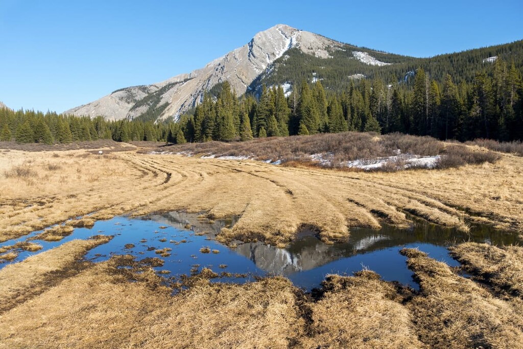
The Panther Corners Public Land Use Zone (Panther Corner PLUZ) is 194 square kilometers (42 square miles) of mixed-use recreation area located to the northwest of the city of Calgary, in Alberta, Canada. There are 8 peaks in the area, the tallest of which is Barrier Mountain with and elevation of (2,957 m / 9,701 ft).
Panther Corners Public Land Use Zone (PLUZ) is 200 km (120 mi) northwest of Calgary, Alberta, and is located within Clearwater County. The PLUZ is also part of an area called Bighorn Backcountry which is a multi use recreation area consisting of the following:
The main access to the area is Highway 40, the Forestry Trunk Road. Sundre, Alberta is the closest town and is located 85 km (51 mi) west of Panthers Corners PLUZ. Access into the PLUZ is by following Ya Ha Tinda Road or the Panther River Road from the Forestry Trunk Road, both of which are unpaved gravel roads.
The Dormer/Sheep PLUZ borders the south of Panthers Corners PLUZ. The Kiska/Willson PLUZ forms a narrow buffer between Panther Corners PLUZ and forestry reserve land that is located to the west.
The Red Deer River is the northern boundary of Panthers Corners PLUZ, and across the river is the Ya Ha Tinda Ranch. The Ya Ha Tinda Ranch is the only horse ranch owned and operated by the Canadian Government. It is used to care for and train the horses that are used in the Rocky Mountain National Parks. Banff National Park is located along the western border of Panther Corners PLUZ.
Panther Corners PLUZ in the eastern end of the Bare Range, which is a front Range of the Canadian Rockies. The Clearwater Ranges are located to the north, the mountains of the Ghost River Area are located to the south, and the Vermillion Range is located to the east.
The front ranges, which the mountains of Panther Corners are a part of, were the last mountains of the Canadian Cordillera to form. The Rocky Mountains began to rise above sea level about 100 million years ago, as result of a collision between the North American continent and tectonic plates that were under the Pacific Ocean.
The collision had been ongoing for nearly 100 million years by the time the Rocky Mountains started to form. The first events of the collision were the accretion of terranes from the Pacific the continental margin. This is when buoyant island chains and micro-continents stuck to the coast of North America, forming the terrane of modern British Columbia, instead of plunging under North America with their previous tectonic plates.
The first mountain building event from the collision is called the Sevier orogeny, in which the Columbia Mountains of interior British Columbia formed and then the Coast Mountains formed. Toward the end of the Sevier orogeny, the Laramide orogeny began which was the event that raised the Rocky Mountains, including those of Banff National Park and Panther Corners PLUZ.
The Canadian Rockies were formed from giant slabs of layered limestone and sandstone that cracked, which we call faults, and were subsequently thrust up and stacked on the layers to the east. This process called thrust faulting pushed the layers nearly vertical in the front ranges of the Rockies, which gives us the very distinct border between the Rocky Mountains and the foothills of Alberta.
After the formation of the Rocky Mountains, the world experienced a period of extensive glaciation. During this time, ice sheets that were over 1 kilometer (0.6 mi) thick covered most of Canada, including the Rocky Mountains. Glaciers spilled out of the Rockies into the prairies and the Laurentide Ice Sheet came from the east to the base of the Rocky Mountains, at times joining together to push glacial debris south.
In one instance, these glaciers combined and moved massive stones and boulders southward. Along the way, these glaciers deposited an erratic train through southern Alberta towards Okotoks, leaving the now famous “big rock.” The Pleistocene glaciation created the current topography of the Rocky Mountains and the Bare Range of the Panther Corners PLUZ.
The glaciers carved the valleys by scouring the soft Cretaceous layers of sandstone and shale, while leaving behind the hard limestone as the uplifted peaks of the range. The glaciers left remnants of their passing as glacial till formations, which include sinuous eskers, kames, and moraines. Cirques and hanging valleys are further scars on the mountains that show the force of glacial erosion.
The Bare Range consists of jagged rocky peaks among its alpine habitat with steep rocky slopes. It is called the Bare Range for the rocky and barren terrain that is common throughout the range except in the lowest valleys. The slab slopes and rocky debris surrounding the mountains and the high-altitude valleys makes the alpine zone of this range quite large, while the subalpine zone is found low on the slopes and it is located mainly in the region’s valleys.
While the alpine region of the Bare Range is barren compared to the landscape of lower elevations, there are still many different plants and animals that inhabit the alpine. Lichen-covered rocks, grassy meadows, mat vegetation, shrubs, and krummholz are common vegetation in the region because the rugged mountain tops do not hold much soil for plants to grow in.
Mountain goats and bighorn sheep are the mammals most commonly found inhabiting the alpine; however, they don’t typically winter among the treeless peaks. The goats and sheep have adapted to use their agility among the rocky outcrops and along the steep cliff to avoid predators during the summer months.
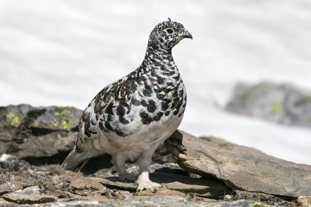
There are some birds that nest in the alpine to keep their young safe from most predators. Some alpine nesting birds include white-tailed ptarmigan, gray-crowned rosy finch, horned lark, and the American pipit. Some small mammals such as hoary marmots, the Columbian ground squirrel, and pika also nest in the alpine rocks for protection from predation.
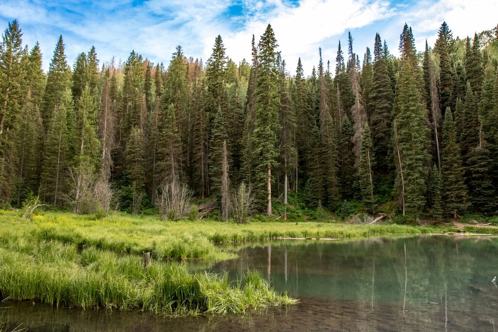
The subalpine region of the Bare Range is primarily contained to the valley floors. The rocky and rugged nature of the range does not allow for trees to grow far up the slopes. The valleys are full of lodgepole pine, alpine fir, and Engelmann spruce/white spruce hybrids. Grasses, willows, creeping juniper, and aspens fill the meadows around many of the valley creeks and rivers.
Large predators such as grizzly bears, black bears, cougars, and wolves make their home in the range. Also, ungulates such as elk, mule deer, white-tailed deer, mountain goats, and mountain sheep are common to the range.
The most animals which you’ll most likely encounter while hiking through the area are the birds and the small mammals. You may hear marmots scream from the rocks or see pika and ground squirrels run along the boundary between the valley and the rocky slopes.
Panther Corner PLUZ is part of the ancient ice-free corridor that connected Alaska and the Yukon to the southern half of North America. About 12,000 years ago groups of people migrated into the expanding ice-free corridor to follow the migrating animals and eventually inhabit the region of southern Alberta and along the Rocky Mountains.
Panther PLUZ is the traditional territory of the Metis, Ktunaxa, Stoney, Tsuu T’ina, and Blackfoot. Peter Pond traveled through the eastern slopes of the region during the late eighteenth century and was followed shortly by David Thompson, both of whom encountered First Nations for the first time.
Later in the nineteenth century, the Simpson expedition of 1841 and the Palliser expedition of 1858 came to the Rocky Mountains. The led settlers further west and they mapped the region for the future railway and national interests.
The land in and around Panther Corners PLUZ was used by settlers and ranchers at the turn of the twentieth century. Families, such as the Brewsters, had large ranching and cattle operations in the area to accommodate their growing tourism business. By 1917, Parks Canada was exclusively using the Ya Ha Tinda Ranch to raise and care for horses required for work in the national parks.
While Panther Corners is a small area, it is located within geological areas that are fascinating to archaeologists as well as enticing to outdoor enthusiasts. The following are some of the trails and attractions to enjoy while visiting Panther Corners PLUZ
The Ya Ha Tinda Ranch is along the northern border of Panther Corners PLUZ, on the north side of the Red Deer River. The ranch is 3,945 hectares (9748 acres) in size and is owned by Parks Canada.
Nearly two hundred horses can be found at the ranch at any time. Here, they are raised before being assigned to a national park. Most of the horses are used by conservation officers to patrol the trails and wilderness areas of the national parks.
The ranch offers opportunities for trail riders and hikers to spend up to two weeks at a time camping and exploring the area. The Bighorn Campground is located on the ranch, while other campgrounds are nearby in Panther Corners PLUZ and Upper Clearwater/Ram PLUZ.
While the land is owned by Parks Canada, and is a designated ranch, there are trails for hiking and riding throughout and many that lead into the surrounding parks and public lands, too. The rich history of the Ya Ha Tinda Ranch adds a layer of interest to the amazing trails and beautiful landscape.
The Hidden Falls Trail starts from the Ya Ha Tinda Ranch and crosses the Red Deer River to your destination. The trail is a 15 km (9 mi) round trip with 463 m (1,519 ft) of elevation gain. This trail is a popular horse trail; however, it is also usable by hikers. This hike makes for a great outing if you are in the area.
The Hidden Falls Trail winds through the forest and hills until you get to the waterfalls. There are two times in which hikers must cross the Red Deer River, and there is no bridge to do so. Therefore, the best time for hikers to use this trail is later in the summer, such as in August and September, when the water has receded and is running a little slower.
There is a route to the top of Barrier Mountain, which is the tallest mountain in Panther Corners PLUZ with an elevation of 2,957 m (9,701 ft). The route is a scramble, and the mountain is typically approached from the west, through Banff National Park.
Route finding, wilderness safety, and scrambling skills are all required to safely attempt this adventure.
Panther Corners is part of the greater area known as the Bighorn Backcountry in Clearwater County, Alberta. The region is relatively uninhabited and provides for incredible backcountry experiences. The following are some places to stay while visiting Panther Corners PLUZ for day trips or towns from which to prepare and launch your adventure.
While Panther Corners PLUZ is within a reasonable range for a day trip, one of the more popular ways to explore this area is camping in the backcountry and taking more time to explore the trails through the mountains. There are campgrounds and facilities near the PLUZ and random camping is available.
Random camping is how locals refer to camping in the wilderness, outside of designated sites, either with a vehicle or hiking. While random camping, care should certainly be taken to leave no trace and to leave the wilderness in the same or better condition than your arrival. Random backcountry camping while hiking is an exciting way to spend time in this remote wilderness area.
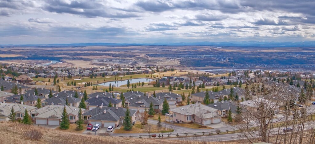
Calgary is located 200 km (120 mi) to the southeast of Panther Corners PLUZ and is the largest city in Alberta. Calgary offers a range of accommodations for visitors as well as some great local attractions.

The most famous event in Calgary is the annual Calgary Stampede, the self-proclaimed “Greatest Outdoor Show on Earth.” Running for 10 days every July, the Stampede has a midway, shows, concerts, rodeo, chuckwagon races, and the nightly Grandstand Show and fireworks.
There are hundreds of kilometers of trails that connect most of the parks and greenspaces around Calgary. The largest natural areas in the city are Nose Hill Park in the north of Calgary, and Fish Creek Provincial Park, in the south of the city. Other nice places for a walk or cycle are around the Glenmore Reservoir and by the Bow River at the Inglewood Bird Sanctuary.
Cochrane is situated about 146 km (88 mi) to the southeast of Panther Corners PLUZ, and is the largest town in Alberta. The town offers accommodations, restaurants, stores and the lovely smell of fresh cut lumber wafting through the town, from the local sawmill.
Along the river, there are pathways and playgrounds to visit, as well as a disc golf course. If you decide to spend some time here, there is the Spray Lakes Rec Centre to visit, which has pools, soccer fields, climbing walls, a splash park, and much more. Cochrane is a lovely town that is located between the conveniences of the city and the beauty of the mountains.
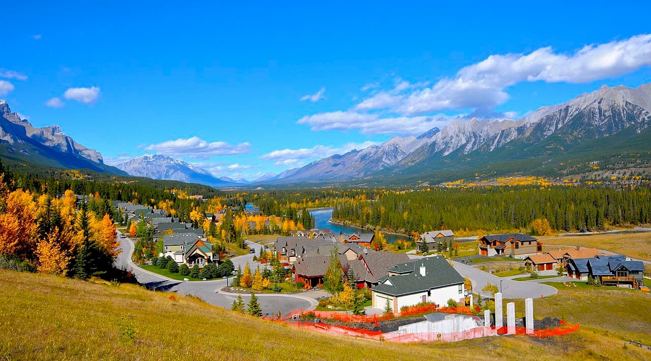
Nestled in the heart of the Bow Valley, Canmore is 167 km (101 mi) from Panther Corners PLUZ and is a very popular tourist destination in the Rocky Mountains. Canmore started as a coal town and matured into a mecca for outdoor recreation in the Rocky Mountains.
Canmore is located near the western edge of Banff National Park, as well as Bow Valley Provincial Park, Bow Valley Wildland Provincial Park, Spray Valley Provincial Park, and many more recreation areas that are part of Kananaskis Country. It's a good place to stay if you’re interested in exploring fun destinations and activities in the region.
The snow-filled months are typically the busiest months in Canmore, as it is a wonderful tourist town for the surrounding ski resorts, such as Sunshine and Lake Louise. Canmore also provides easy access to hiking trails like Ha Ling Peak, Chester Lake and Grotto Canyon. In addition to hiking, Canmore offers ample opportunities for road and mountain biking.