
Scan the QR code and open PeakVisor on your phone
Situated along at the confluence of the Bow River and the Spray River, 100 km (60 mi) west of Calgary, Alberta, Canmore started as a coal mining town and has grown into a Rocky Mountain tourism hot spot. Canmore has no peaks within the town except the Wind Ridge high point (2,179 m/7,149 ft); however, Canmore is synonymous with the Three Sisters mountain, with the 1 named peaks of the Big Sister (Faith Peak), Middle Sister (Hope Peak), and the Little Sister (Charity Peak).
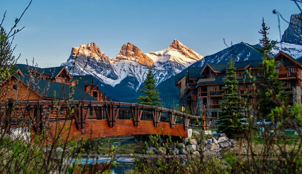
The town of Canmore is in the Bow Valley corridor of the Canadian Rockies in southwest Alberta, Canada. Located about 100 km (60 mi) west of Calgary, Alberta and 22 km (12 mi) east of the town of Banff, Canmore borders the eastern gate of Banff National Park.
Canmore is located in the southwest corner of the Municipal District of Bighorn, and is the only sizable town in the district. The rest of the district is covered with mountains and hills that are designated as parks, public land use zones. The Bow River runs from Banff, through the town of Canmore, and it is the border to the Municipal District of Bighorn.
Canmore is mostly surrounded by protected wilderness areas, with Banff National Park to the west and Kananaskis Country to the south and east. Banff National Park was Canada’s first national park, while Kananaskis Country is a large multi-use recreation area in Alberta. Nearby Kananaskis has six provincial parks, four wildlands provincial parks, and dozens of other recreation areas and natural areas, so it’s also worth checking out if you’re in the area.
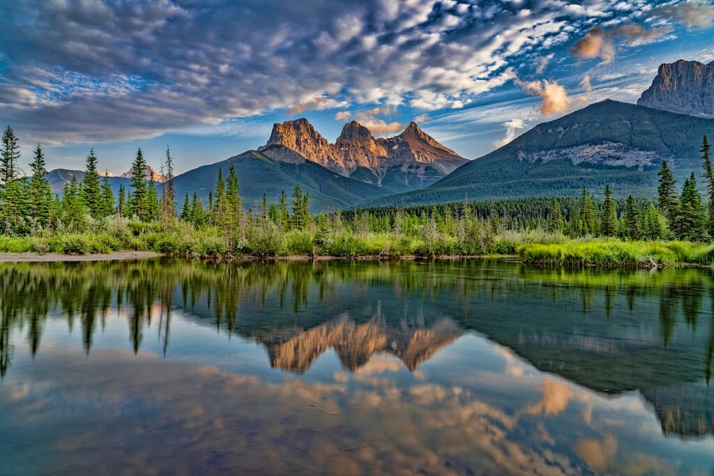
Located along the Bow River, Canmore is within the front ranges of the Rocky Mountains. The Fairholme Range is located to the northeast of Canmore while the Kananaskis Range is to the south and both the Goat and Sundance ranges are to the southwest.
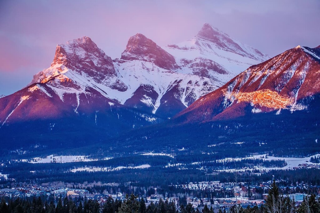
Some of the notable mountains surrounding Canmore are the iconic Three Sisters, Ha Ling, Grotto Mountain, and Mount Rundle. The mountains around Canmore formed about 45 million years ago during the Eocene epoch.
For about 40 million years, the tectonic plates from the west were pushing against the North American plate. This forced slabs of Paleozoic limestone and dolomite to slide over the younger, Mesozoic shales and sandstones.
The layers of stone were pushed up from the sea floor, many kilometers into the air and breaking along what we call fault lines. The slabs of stone were forced nearly vertical in the front ranges, which is noticeable from the highway as you pass vertical faces of Mount Yamnuska and Door Jamb Mountain to the north as you head towards Canmore.
The nearly vertical slabs of sandstone and shale eroded much faster than the harder limestone and dolomite. These days, sedimentary limestones and dolomites are found mostly in the mountains, while the erosion of the non-marine sandstone and shale created the valleys between the ranges.
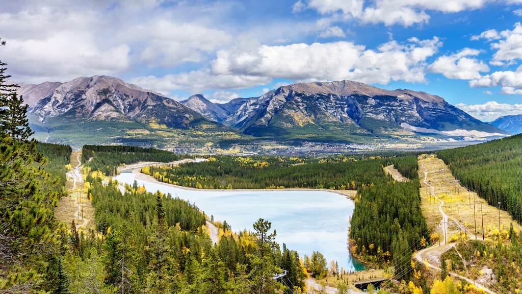
Canmore lies in the Bow Valley which was formed as glaciers formed and melted over millions of years. However, the local topography really started to take its shape during the Pleistocene, which saw repeated periods of glacial erosion.
The glacial activity is evidenced in the landscape around Canmore. In particular, the valley floor contains rocks and other debris that were eroded from the mountains. Many rock formations around Canmore, such as eskers, kames, and drumlins show how glaciers moved through the valley. Additionally, many of the smaller lakes were created from large pieces of ice which were left behind during the widespread glacial retreat 12,000 years ago.
By the late twentieth century, Canmore shifted from an economy dependent upon natural resource extraction to one that required protection of natural resources and landscapes. This shift allowed for continued protection of the local wildlife habitats and ecosystems.
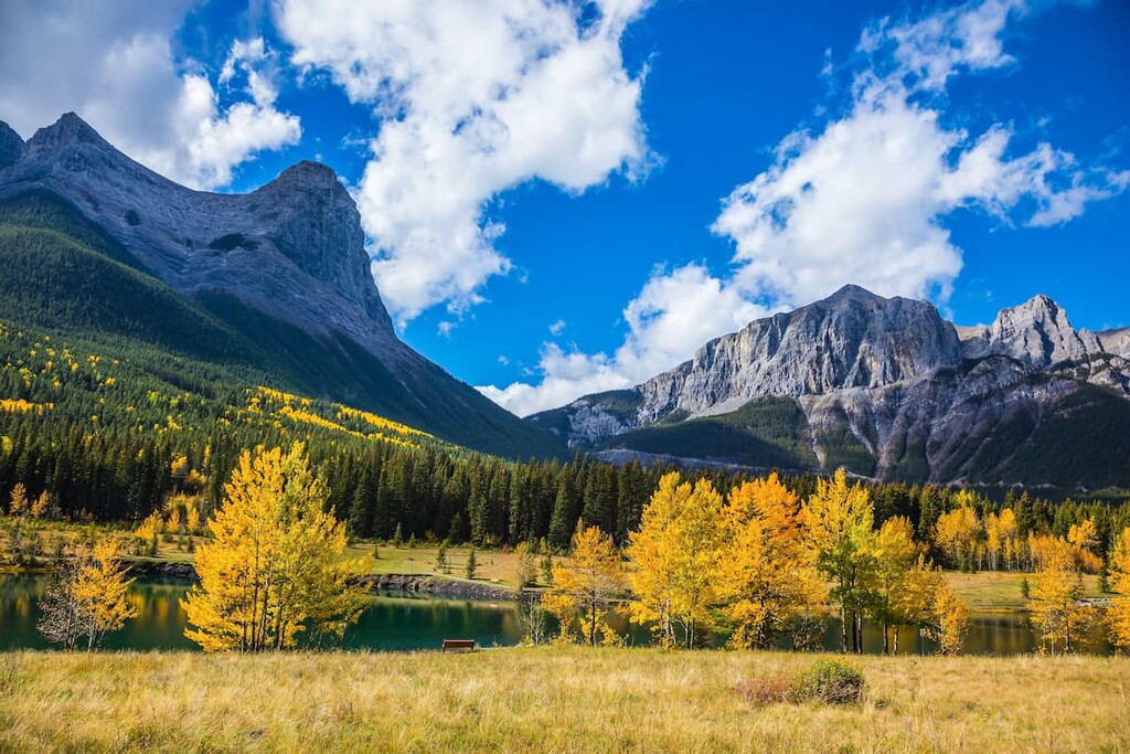
The ecology around Canmore is part of the montane ecological region, which is the most diverse ecological region in the Rocky Mountains. The town and area are characterized by a mixture of forests and grassy meadows. The town also encompasses the Bow River, tributary creeks, ponds, and wetlands with their respective ecosystems.
Forest of lodgepole pine and Engelmann spruce carpet the slopes around town with patches of Douglas fir, aspens, larch, willows, and birch. The forest and meadows are home to many species of birds and mammals. Eagles and falcons hunt from the sky, while cougar, wolf, coyote and fox hunt on the ground. Bears roam and forage as they please in the region, while ungulates like moose, elk, bighorn sheep, and deer wander the forests and meadows.
It is common for wildlife to wander through town, especially close to the river and the creeks. It’s not just the elk and deer, but also cougars and bears enter the town at times. The town has rules to minimize wildlife and human interactions to protect the animals and people. Rules range from keeping garbage secured to removing bird feeders during the summer. Rabbits are also a large part of the Canmore ecosystem.
The thousands of rabbits that inhabit the town are likely descendants of domesticated rabbits released into the wild. Despite the various predators in the area, the rabbit population has thrived over the past 30 years.
Strategies to control the population have included adoption, sterilization, and euthanasia, all to no avail. While most residents think the rabbits are cute and adorable, the bunnies also lure large predators, such as cougars, into the town, risking dangerous wildlife encounters with humans.
As the glaciers were retreating from the valleys and mountains human populations began to move into the area. The first people known to occupy the Canmore area were of the Clovis culture, who were big game hunters with a distinctive projectile point. Following came people from the culture of the Mummy Cave Complex in the US state of Wyoming. It is believed that the area has been continuously inhabited for over 10,000 years.
There are more than 30 significant archaeological sites around Canmore, which include rock quarries, campsites, workshops, rock shelters, stone cairns, and pictographs. Many different cultures immigrated to and emigrated from the area as the climate shifted and as animal migratory patterns changed.
About 200 CE, the Avonlea culture came to the valley and brought with them knowledge of the bow and arrow. It is possible that the Avonlea are ancestors of the Kootenai people, whom David Thompson encountered in the area in 1800.
In November of 1800, David Thompson became the first recorded European to enter the Bow Valley of the Rocky Mountains. By the 1840s, the Blackfoot Confederacy had forced the Kootenai westward, making them the dominant nation on the eastern slopes of the Rockies. The Blackfoot Confederacy was eventually forced off its ancestral homelands by the arrival of settlers of European descent.
The middle of the nineteenth century saw the Palliser expedition map and survey the Rocky Mountains, which set the stage for the completion of the transcontinental railway lines to unite Canada from east to west. As the railway extended into the Rockies, a divisional point was created 100 km (60 mi) to the west of Calgary. It was then named Canmore by Canadian Pacific Railway pioneer Donald A. Smith after Malcolm Ceann Mor (Canmore) III, who killed Macbeth the usurper in the fight for the Scottish throne in 1057.
Photo at Canmore Nordic Centre
Since its incorporation as a town in 1884, Canmore quickly grew as a mining town and coal mining ran the local economy until 1979, when the last coal mine, Canmore Mines Ltd. closed. For nearly a decade the town struggled until the late 1980s when it was able to reinvent itself, thanks to the 1988 Calgary Winter Olympics.
The 1988 Olympics were hosted by Calgary; however, there were many mountain skiing events that took place in the mountains to the west of the city. A lot of infrastructure was created, and Canmore was the beneficiary of some of the investment.
In 1988, Canmore was set on the world stage and because of the natural beauty of the mountains and the easy access to outdoor recreation, it was transformed into an outdoor recreation mecca for tourists and local Albertans, and that reputation persists to this day.
Canmore’s mountain location has created a vibrant culture that celebrates nature, people, and creativity. There are so many activities that Canmore has to offer, including: hiking, cycling, climbing, scrambling, fishing, hunting, skiing, snowshoeing, disc golf, and rafting.
The town has over 70 km (43 mi) of trails in addition to the Canmore Nordic Center with its 65 kilometers (40 mi) of winter cross-country ski trail and 100 kilometers (60 mi) of summer trails for biking, running, orienteering, roller skiing, and hiking.
In addition to outdoor recreational activities, Canmore hosts and celebrates countless events for visitors and locals, alike.

National and international Nordic events are hosted at the Canmore Nordic Center including skiing, biathlon and dog sledding competition. There are also a number of festivals in Canmore to celebrate indigenous culture, folk music, the environment, and local artists throughout the year.
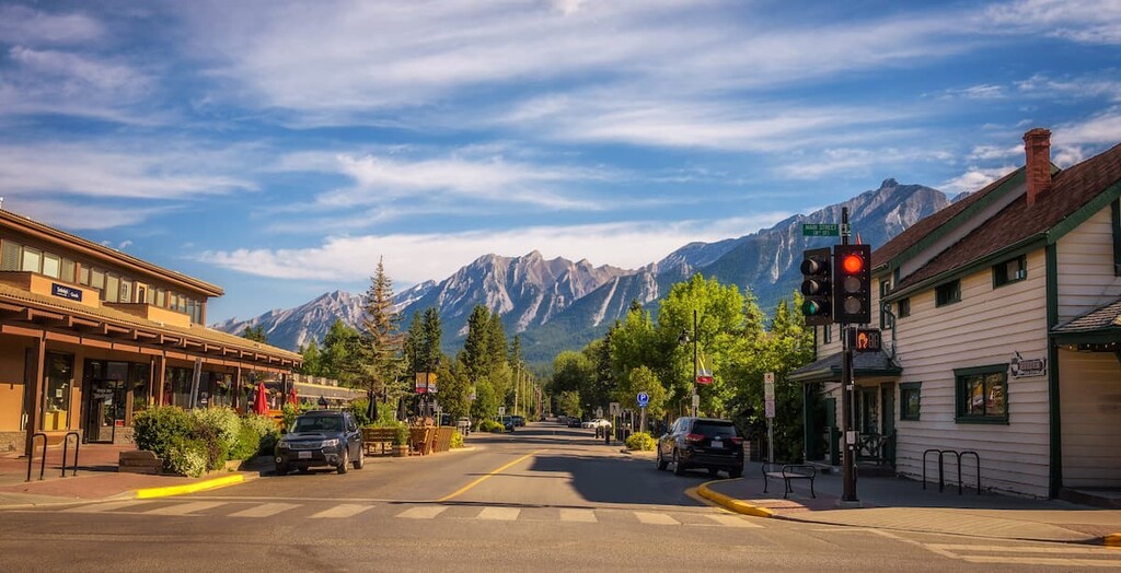
If you’ve just arrived in Canmore, taking a walk down the main street and speaking with the shop owners and the artists in the galleries is a way to start connecting with people who currently call this place home. Plus, you may even get some tips as to where the locals go for fun.
With over 70 km (43 mi) of local trails and being surrounded by mountains, there is no shortage of hikes and activities in the area. The following are a sampling of trails that start to explore the town and surrounding region.
The Legacy Trail is a paved 4.5 km (2.8 mi) trail from the Travel Alberta Visitor Information Centre in Canmore to the east gate of Banff National Park. Beyond the gates, the paved trail continues for 22 km (14 mi) and leads to the town of Banff. The whole trail is referred to as the Rocky Mountain Legacy Trail and was built to commemorate and honor Banff National Park’s 125th anniversary.

The trail was built to celebrate the values of the parks, and encourage visitors to explore the parks in an environmentally friendly way. The trail is popular with recreational cyclists because it is possible to travel the distance to and from Banff in several hours of relaxed cycling, all while enjoying the landscape and scenery.
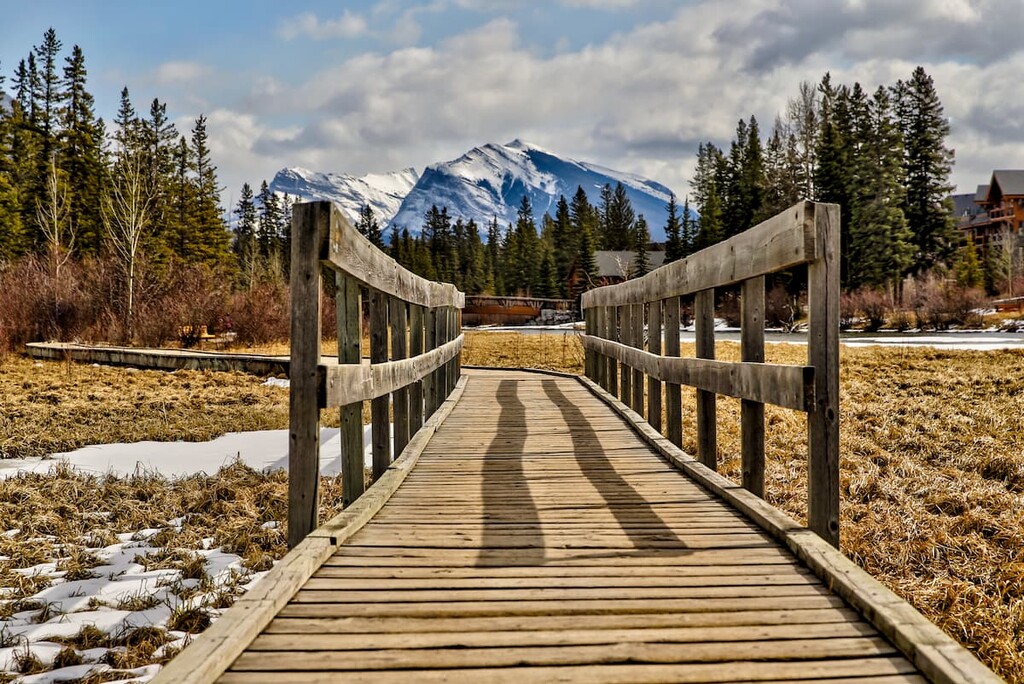
The Policeman Creek Trail is an easy 3.8 km (2.4 mi) loop that takes you around and through Canmore. As the name implies, much of the hike will take you along Policeman’s Creek; however, there is a section that leads through some of the streets of Canmore’s commercial and historical district. This trail is a great way to familiarize yourself with the natural and historical areas of Canmore.
This trail was built in 1921 by Lawrence Grassi and some of his friends. It stands as a testament to his trail building ability. The two turquoise lakes at the destination were named in Grassi’s honor who was a legendary trail builder in the Rocky Mountains. He had worked for the railway and as a miner; however, his passion was mountaineering and guiding.
The 4 km (2.5 mi) return leads through a peaceful forest to the base of a waterfall. The trail continues up the cliff and you arrive and two of the most picturesque lakes with turquoise water and bands of greens, oranges, yellows, and reds on the bottom. There is a large cliff comprising an ancient Devonian reef that is popular for climbing. Beyond the lakes, a short trail leads to pictographs that are thousands of years old and were likely painted as part of a vision quest.
With a waterfall, an ancient coral reef cliff, rock shelters, beautiful lakes, a peaceful forest, ancient rock paintings, accessible sport climbs, this trail and destination are incredible. There is also an alternate path along the TransAlta Road that makes this an easy hike with children in strollers.
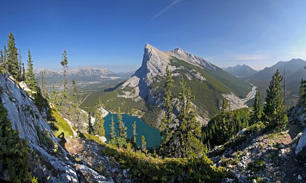
This is a 4 km (2.5 mi) trail that leads to the summit of Ha Ling Peak. The first 3.5 km (2.2 mi) of the trail are maintained; however, the last half kilometer to the peak is an easy scramble that traverses loose, rocky terrain on an unmaintained trail. The trail ascends about 700 m (2,300 ft) from the canal below, with access to Miners Peak as well as Ha ling Peak.
While it may be tempting to traverse the ridge to the peak of Mount Lawrence Grassi, the path requires significant route-finding skills and should not be attempted without sufficient experience; however, there is a separate trail that ascends from the canal to the peak to the peak of Mount Lawrence Grassi along the west slope if you’re keen on reaching that peak.
The history of Ha Ling Peak is fascinating, and it may bring you added enjoyment while you hike to the peak. While working as a cook at Oskaloosa Hotel in Canmore in 1896, a $50 bet was made that Ha Ling couldn’t climb the peak and return in less than 10 hours. Ha Ling set out one day at 7 am with a small flag to set on the summit, and he returned for lunch at 12:30 pm to the dismay of those who made the bet.
Nobody believed that Ha Ling had attained the summit and returned so quickly, so the following day Ha Ling hiked to the summit again, with the disbelievers in tow. Once they all reached the summit, they saw his little flag from the previous day pinned beneath some rocks and flapping in the wind.
The peak was originally named Chinamans Peak; however, it was finally changed to Ha Ling Peak to remove the racist term and properly honor the man who achieved the first recorded ascent of the peak.
Along the Bow River and in the Rocky Mountains there are many places to see and many adventures to be had. The following are a couple alternative locations to resupply or from which to base your next adventure.
Calgary is located 100 km (60 mi) to the east of Canmore, and is the closest city to the town. While in Calgary, it is easy to gaze west towards the mountains and overlook all that the city has to offer. However, it’s worthwhile to vacation in Calgary, or at least bookend your mountain vacation with a day in the city, to experience its unique mountain and western culture.

The city offers many cultural events and attractions that include the Glenbow Museum, the Calgary Tower, the Calgary Philharmonic Orchestra, the Calgary Opera, Alberta Theater Projects, and many more to suit all tastes and budgets. There are incredible chefs cooking at restaurants around the city, and they offer a wide range of fare.
While in Calgary, visitors and residents can rent electric scooters and bicycles to navigate the pathway system that spans the entire city, connecting all the major parks and green spaces, including Nose Hill Park and Fish Creek Provincial Park. The Inglewood Bird Sanctuary is a fascinating place to visit as is the Calgary Zoo.
The Rocky Mountains dominate the western horizon; however, you won’t be disappointed if you retract your gaze and look to Calgary for part of your adventure.
Located in Banff National Park, the town of Banff is about 25 km (16 mi) west of Canmore and is the birthplace of Canada’s national parks. It can be reached by driving down Highway 1, or from Canmore, you can walk, bike, inline skate, cross-country ski, or snowshoe the 26 km (16 mi) Rocky Mountain Legacy Trail that spans the two towns. Canmore has a distinct mountain culture in the town; however, when compared to Banff, Canmore appears cosmopolitan.
Banff was founded to cater to tourists looking for a unique and spectacular mountain experience. Whether that experience is basking in the hot springs and looking upon the mountains or fully immersing yourself in the wilderness by trekking to the nearby summits, is up to the individual. Mountains dominate the skyline and beautiful mountain architecture fills the streets. From the museums and historical sites to the trails, Banff will not disappoint.


