We use necessary cookies to make the website work, also they are used to understand site usage and make improvements.
Accept
Reject
PeakVisor
Explorer
Explorer
Ski Map
Hike Map
3D Map
Get PeakVisor App
Sign In
Search by GPS coordinates
Teleport
Latitude
N
S
°
'
''
Longitude
E
W
°
'
''
Units of Length
m/km
ft/mi
Explorer
Ski Map
Hike Map
3D Map
Search by GPS coordinates
Settings
Sign In
Contact us
GPS coordinates
Settings
Share
×
Copy Link
Copy Coordinates
Facebook
Twitter
Email
Scan the QR code and open PeakVisor on your phone
❤ Wishlist
×
Choose
Delete
Amelia Bysinger
Mountain
28
Mountain Hut
0
Mountain pass
10
Lake
2
Ultra
1
Highest check-in
Peak:
Mount Mitchell
Elevation:
2 038 m
Most prominent check-in
Peak:
Mount Mitchell
Prominence:
1 862 m
40 check-ins
By Date
By Date
By Elevation
By Prominence
Red Top Mountain
1705202280
324 m
(prom:
50 m
)
Caesars Head Mountain
1700336611
980 m
(prom:
76 m
)
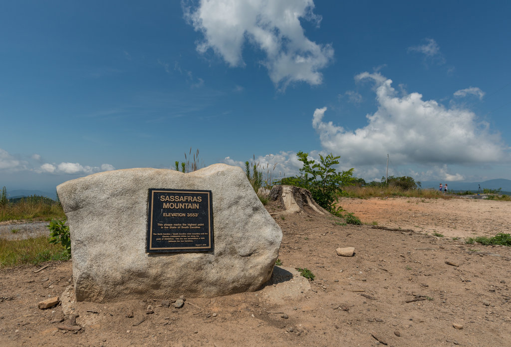
Sassafras Mountain
1700331630
1 087 m
(prom:
239 m
)
Folly Gap
1700329372
861 m
Chimneytop Gap
1700329139
734 m
Beasley Gap
1700328625
575 m
Neal Gap
1691942427
508 m
Hallback
1690053225
1 946 m
(prom:
59 m
)
Stepps Gap
1690051378
1 855 m
Mount Mitchell
1690048658
2 038 m
(prom:
1 862 m
)
Black Mountain Gap
1690046261
1 571 m
Craven Gap
1690041610
955 m
Pine Mountain
1688836185
355 m
(prom:
29 m
)
Pine Mountain
1687630883
476 m
(prom:
180 m
)
Lost Mountain
1686353572
463 m
(prom:
143 m
)
Pine Mountain
1686349741
399 m
(prom:
69 m
)
Little Kennesaw Mountain
1686342822
490 m
(prom:
50 m
)
Pigeon Hill
1686338697
380 m
(prom:
7 m
)
Kennesaw Mountain
1686334654
551 m
(prom:
221 m
)
Stone Mountain
1685897167
514 m
(prom:
212 m
)
Luftee Gap
1683309759
1 556 m
Clingmans Dome
1683306665
2 025 m
(prom:
1 377 m
)
Forney Ridge
1683304962
1 957 m
(prom:
1 m
)
Graves Mountain
1682713020
272 m
(prom:
112 m
)
Mount Oglethorpe
1682195516
1 000 m
(prom:
113 m
)
Fort Mountain
1682181797
868 m
(prom:
109 m
)
Emory Gap
1680459540
353 m
Cheaha Lake
1680458760
390 m
Pulpit Rock
1680456000
599 m
Bald Rock
1680451129
707 m
(prom:
15 m
)
Cheaha Mountain
1680449128
734 m
(prom:
444 m
)
Horseblock Mountain
1680446859
454 m
(prom:
93 m
)
Abel Gap
1680446059
326 m
Blackrock Mountain
1679161800
1 109 m
(prom:
335 m
)
Bell Knob
1673037000
1 042 m
(prom:
262 m
)
Brasstown Bald
1673032970
1 458 m
(prom:
647 m
)
Chatuge Lake
1673031600
605 m
Paris Mountain
1671388620
392 m
(prom:
21 m
)
Vinson Mountain
1671386700
403 m
(prom:
31 m
)
Lookout Mountain
1659978420
655 m
(prom:
121 m
)
Georgia 4000-foot Peaks
All summits:
1 out of 35
Carolina Lookout Tower Challenge
All summits:
2 out of 22
Fred Beckey's Great Peaks of the Continent
All summits:
1 out of 35
Tennessee 4500-foot Peaks
All summits:
1 out of 82
Southern Appalachian 6000-foot Peaks
All summits:
3 out of 56
North Carolina 5000-foot Peaks
All summits:
3 out of 232
South Beyond 6000
All summits:
3 out of 41
South Carolina 3000-foot Peaks
All summits:
2 out of 34
USA
Independent peaks:
5 out of 7529
Highpoints:
5 out of 56
Georgia
Independent peaks:
2 out of 21
Highpoints:
4 out of 41
Alabama
Independent peaks:
1 out of 5
Highpoints:
1 out of 46
Tennessee
Independent peaks:
1 out of 53
Highpoints:
2 out of 77
North Carolina
Independent peaks:
2 out of 92
Highpoints:
2 out of 46
South Carolina
Highpoints:
1 out of 16
Appalachian Mountains
Independent peaks:
5 out of 672
Talladega National Forest (Talladega Division)
All summits:
3 out of 31
Chattahoochee-Oconee National Forest (Blue Ridge District)
Independent peaks:
1 out of 9
Talladega National Forest (Shoal Creek District)
All summits:
1 out of 24
Great Smoky Mountains National Park
Independent peaks:
1 out of 9
Blue Ridge Parkway
Mount Mitchell State Park
All summits:
2 out of 13
Jocassee Gorges Wildlife Management Area
All summits:
1 out of 32
PeakVisor for iOS and Android
Be a superhero of outdoor navigation with state-of-the-art 3D maps and mountain identification in the palm of your hand!
Scan the QR code to download PeakVisor mobile app