
Scan the QR code and open PeakVisor on your phone
The Fraser-Thompson Plateau is a large highland area located in the central part of British Columbia, Canada. It extends from Williams Lake to Kamloops. The plateau contains 84 mountain peaks, the tallest of which is Blustry Mountain with 2,334 m (7,657 ft) of elevation and 1,477 m (4,846 ft) of prominence.
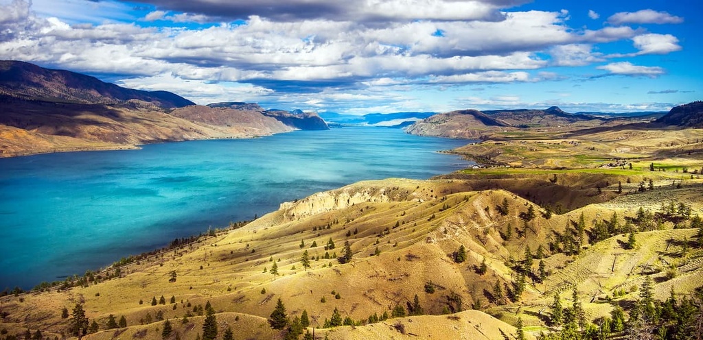
Located in central British Columbia, Canada, the area defined as the Fraser-Thompson Plateau stretches from Williams Lake in the northwest to Kamloops in the southeast. It contains the southeastern part of the Fraser Plateau and the northern part of the Thompson Plateau. There are 87 named peaks in the area.
The Thompson River defines the southern limit of the plateau while the Fraser River is the western border. Meanwhile, the North Thompson River is the eastern boundary and Williams Lake is situated at the north end of the area.
There are many highways that cross the area, making the parks and mountains of the region easily accessible. Highway 1, the Trans-Canada Highway, follows the Thompson River along the south of the plateau and Highway 5 follows the North Thompson River along the plateau’s eastern edge. Highway 97, the Caribou Highway, bisects the area from north to south.
The area is adjacent to Wells Gray Provincial Park and there are many provincial parks and protected areas in the region. The following are the provincial parks in the Fraser-Thompson Plateau area:
The area of the Fraser-Thompson Plateau is part of the Interior Plateau of British Columbia, which includes the Nechako Plateau in the north, the Fraser Plateau, and the Thompson Plateau in the south.
The Thompson part of the area includes the subranges of the Tranquille Plateau and Batchelor Ranges. The Fraser part of the area encompasses the Clear Range, Marble Range, and the Arrowstone Hills. Meanwhile, the Quesnel and Shuswap Highlands are located to the east and the Pacific Ranges are situated to the west.
The formation of the plateaus started about 150 million years ago as land was slowly being added to the west coast of what is now Canada. Most of British Columbia was created through accretion of terranes. This happened as tectonic plates subducted beneath the North American plate and the buoyant island arcs and microcontinents joined to the west coast of the continent.
The subduction of the oceanic tectonic plates beneath the North American plate is also what caused the formation of the Western Cordillera, which includes the Coast Mountains in the west, the Columbia Mountains, and the Rocky Mountains. The Interior Plateau, which includes the Fraser-Thompson Plateau, is located between the Columbia and Coast Mountains.
Before the Eocene, the Thompson Plateau was a mixture of layers of lava and Paleozoic sediment, like the limestone peaks of the Rocky Mountains. About 55 million years ago, toward the end of the Laramide orogeny, which was responsible for the formation of the Rocky Mountains, there was immense volcanic activity in the area of the Thompson Plateau.
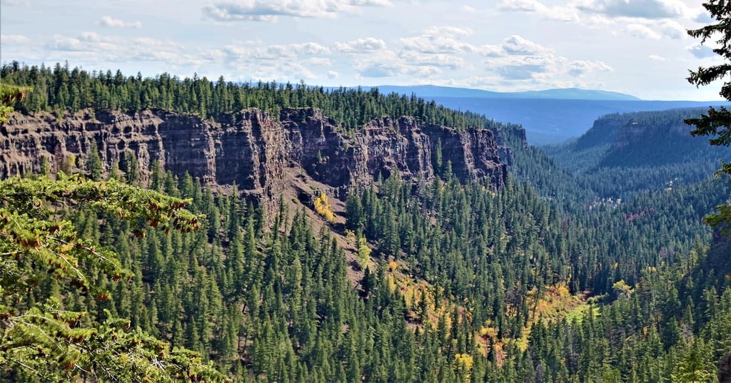
During the Eocene, volcanic eruptions covered the region in a thick layer of basaltic lava, creating the wide, flat plateau that we see today. However, the creation of the Fraser Plateau was much more recent, as the lava that created the Fraser Plateau only erupted during the Pliocene and Miocene.
Significant portions of the Fraser Plateau were created from lava flows that occurred about 5 million years ago. These later lava flows create an interesting topography with a nearly flat upper surface and steep escarpments along the rivers and creeks. The plateaus are separated from each other by near-vertical cliffs.
Within millions of years of the eruptions that created the Fraser Plateau, the world entered an extended glacial period during the Pleistocene. Glacial periods started with increased snowfall in the mountainous areas where the snow accumulates year after year, instead of fully melting in the summer.
The gradual accumulation of snow compacts the older snow so much so that it becomes ice and starts to flow downhill. With time, these sheets of ice reached thickness of up to 3 km (1.8 mi) in some areas of the western mountains.
As the glaciers moved, they ground down the mountains and displaced the eroded rocks and sediments covering the Fraser and Thompson Plateaus with a thick layer of glacial drift. Besides the mountains, the drumlin-like forms and eskers created by moving ice and glacial rivers form most of the topographical relief on the plateaus that we see today.
The Interior Plateaus are part of an area of subdued relief compared to the Coast Mountains in the west and the Columbia Mountains in the east. Thanks to their lower elevation and proximity to the tall Coast Mountains, the Fraser-Thompson Plateau is part of a rain shadow. Here, precipitation levels are significantly lower than those in the surrounding mountains.
The primary ecology of the Fraser-Thompson Plateau area is the dry, Interior Douglas Fir ecology. The elevated mountainous areas are part of the Montane Spruce and Engelmann Spruce-Subalpine Fir zones. Meanwhile, the river and lake valleys are even drier than the surrounding plateau. They are home to Bunchgrass and Ponderosa Pine ecologies.

The flatlands of the Fraser-Thompson Plateau are characterized by the Interior Douglas Fir ecology. The flatland ecology is the second warmest forest zone of the dry interior, the warmest being the Ponderosa Pine zone. The dominant trees here are Douglas fir with a pine grass understory; however, frequent forest fires in the region have resulted in large stands of equal-age lodgepole pine at higher elevations and ponderosa pine at lower elevations.
Wetlands form in depressions and around open water in this ecological area. They are filled with cattails, sedges, and bulrushes, along with shrub willow and birch. Red-osier dogwoods are prominent in the fall, particularly after their leaves have fallen and their red stems stand out in an otherwise green landscape.
The drier limits of the zone are savannah-like and support large communities of bunchgrass, such as rough fescue, junegrass, and bluebunch wheatgrass.

The hottest and driest areas of the Fraser-Thompson Plateau are the lowlands that typically border the large lakes and rivers between the plateaus. The Douglas fir forests of the flatlands open to the parkland-like forests of ponderosa pine. The thick bark helps make the trees resistant to the fires that are common in such dry areas.
The understory of the lowland’s forests are filled with bluebunch wheatgrass, rough fescue, and arrow-leaved balsamroot. Saskatoon, yarrow, lemonweed, and pasture sage are also common, whereas shrubs and young trees are uncommon in the understory.
The Bunchgrass ecologies of the valleys are like the anti-alpine zone, where in the alpine, winds and snowfall make it difficult for trees to grow, while in the river valleys, it’s the persistent heat and drought that make the valleys barren of trees, making grasses the dominant plant.
Some of the drought resistant plants that grow in the hot Bunchgrass ecological zone are bluebunch wheatgrass, needle-and-thread grass, junegrass, and Sandberg’s bluegrass. Shrub-steppes often dominate the lower elevations with sagebrush; rabbit-brush is also present but it is not dominant.

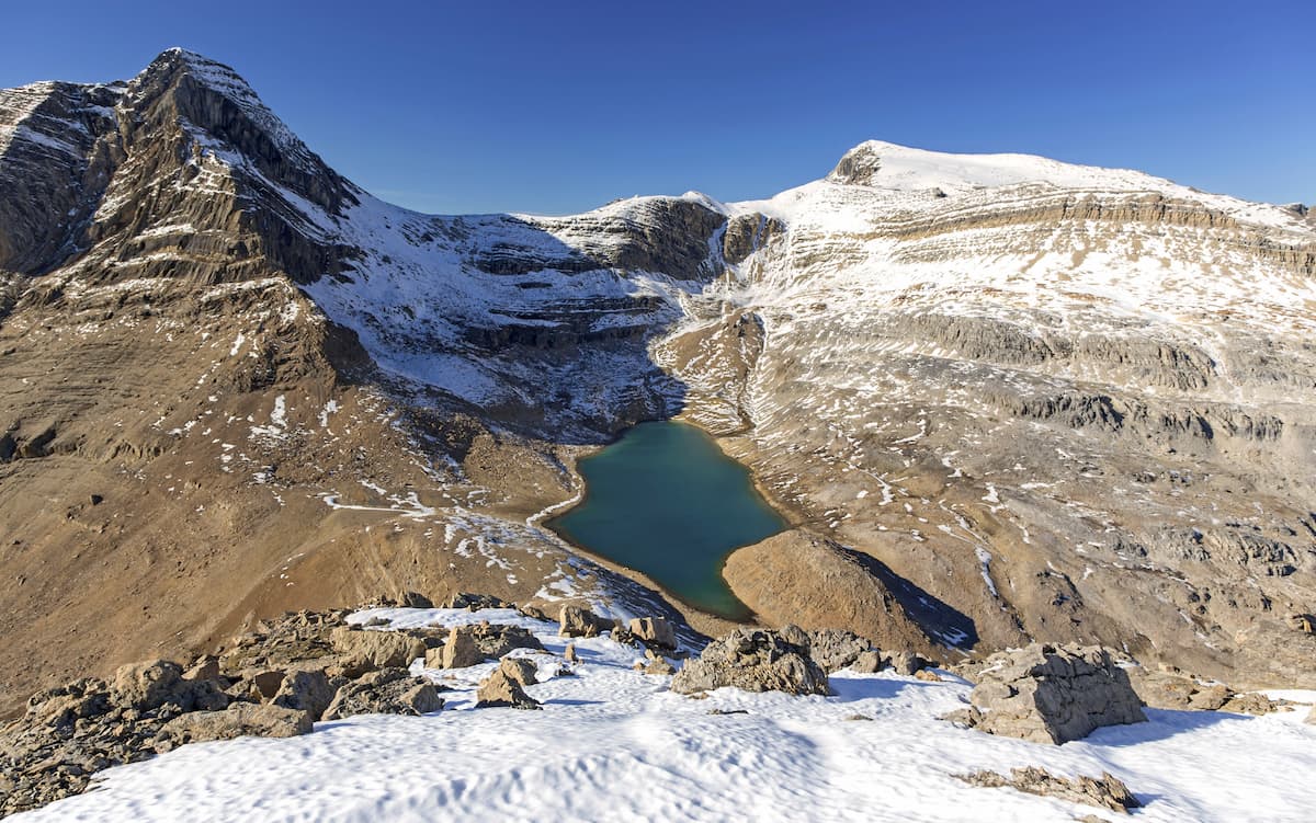
The mountains of the Fraser-Thompson Plateau area do not reach exceptional elevations like the Columbia mountains to the east, or even the Coast Mountains to the west. As such, the peaks are all considered subalpine and part of the Engelmann Spruce-Subalpine Fir zone. Additionally, the lower slopes are part of the Montane Spruce zone.
The Montane Spruce zone is a transitional ecology between the interior Douglas fir forests and the subalpine forests of Engelmann spruce and subalpine fir. The forests of Douglas fir and lodgepole pine gradually transition to the Engelmann spruce–dominated forests. Eventually, they transition into forests that are dominated by subalpine fir near the peaks of the region.
Since Engelmann spruce tends to live longer than subalpine fir, the forest canopy is usually dominated by spruce; however, the understory and the upper elevations of the plateau are filled with subalpine fir. Extensive stands of lodgepole pine are common in the region because they are the first tree to grow after forest fires. Eventually Engelmann spruce and subalpine fir trees grow as the forest matures.
The wide variety of ecologies on the Fraser and Thompson Plateaus supports many habitats for a large variety of animal species.
Starting with the lowest elevations, the Bunchgrass zone supports a tremendous diversity of animals. The area is the northern limit for animals such as the short-horned lizard, burrowing owl, and the pallid bat. The snowy owl and gyrfalcon also migrate to the zone for winter.

The lower, warmer bunchgrass zone provides ideal winter habitat for most of the species that live on the Fraser and Thompson Plateaus. The Rocky Mountain elk, bighorn sheep, and mule deer migrate to lower elevations for the winter.
The lower elevation forests of ponderosa pine and Douglas fir are favored by white-headed woodpeckers, Lewis’ woodpecker, Townsend’s big-eared bat, and the yellow-pine chipmunk. In moist areas with forests of alder, cottonwood, aspen, and willow, there are populations of wood duck, American kestrel, California myotis, and many other small mammals.
Other animals such as grizzly and black bears, wolves, moose, white-tail and mule deer, coyotes, and cougars inhabit the plateaus. Most of the animals that don’t hibernate will migrate to lower elevations during the winter, where the snow is not as deep and travel and foraging for food is easier.
Evidence of human habitation on the Fraser and Thompson Plateaus comes from the uncovering of the remains of ancient settlement areas adjacent to the Fraser River. This archaeological evidence suggests that permanent habitation on the plateau began about 8,000 years ago.
It’s believed that, about 4,000 years ago, members of the Coastal Salish culture moved inland from the west coast to settle significant areas of inland British Columbia. The Salish culture supplanted the previous culture as the annual subsistence patterns changed, the Salish were already adept at catching salmon for subsistence, a practice that proved vital to their survival.

For the past 4,000 years, the Salish culture flourished in the river valleys of the region while creating communities with complex social hierarchies and cultures. The transition from annual mobile hunting rounds to village life began about 2,000 years ago when local First Nations began using salmon as their primary winter food source.
The way of life for the First Nations of the region remained relatively unchanged until the arrival of European fur traders in the early nineteenth century. Eventually, many members of local First Nations on the Fraser and Thompson Plateaus turned to ranching and other forms of work.
The Fraser and Thompson Plateaus are part of the traditional territory of the Secwépemc (Shuswap) and the Nlaka’pamux (Thompson) First Nations. Both the Secwépemc and the Nlaka’pamux are descendants of the members of Salish culture that moved inland from the west coast 4,000 years ago.
Today, the region has many towns and cities with economies based around the ranching, forestry, sawmills, and mining that occurs in the region. The mild winters and dry summers also draw many outdoor enthusiasts to the region, so much so that tourism has become an important economic activity to the area.
The vast plateaus, accessible mountains, and incredible rivers of the Fraser-Thompson Plateau area serve as an amazing wilderness playground for outdoor enthusiasts. The following are some of the major hiking areas, trails, and attractions to find while touring the Fraser and Thompson Plateaus of British Columbia.
Rising up from the Thompson Valley below, the Lac Du Bois Grasslands Protected Area contains a unique mixture of distinct grassland ecologies, spectacular canyons and cliffs, small lakes, secret ponds, and cool forests. Here, ancient ponderosa pines stand as sentinels over the grasslands while 400-year-old Douglas firs dominate other parts of the forest.

The main trails in the Lac Du Bois Grasslands Protected Area are the Mara Trail, which is a short interpretive trail; the Cinnamon Ridge Trail, which ascends part of Mara Hill; and the Dewdrop trail, where you may encounter California bighorn sheep. Additionally, there is the 13 km (7.8 mi) Grasslands Community Trail, which leads through all three of the grassland ecologies with a stop at Deep Lake.
The chasm of Chasm Provincial Park was formed 10,000 years ago. It formed as a result of the erosive power of the region’s silt-heavy glacial melt water. Over thousands of years, these melt waters carved the 8 km (4.8 mi) long, 600 m (1,968 ft) wide, and 300 m (984 ft) deep chasm. Additionally, a 40 km (24 mile) long esker stretches upstream from the head of the chasm.
Established in 1940, Chasm Provincial Park only encompasses 31 square kilometers (12 square miles) of land and there are no official hiking trails in the park. However, there are many informal trails, many of which follow old roads. One of the old roads leads along the southern edge of the chasm, offering spectacular views along the way.

The Marble Range is named for the interesting karst topography that is prevalent in the range. The mountains feature caves, sinkholes, disappearing streams, cliffs, chasms, and crenellated ridges. There are unmaintained trails throughout the park, leading to the various viewpoints as well as limestone cave and rock formations.
Most of the karst formations of Marble Range Provincial Park can be accessed and viewed from high in the alpine. While hiking in the alpine, you may be privileged to see some of the bighorn sheep and other animals that inhabit the ranges.
During the 1800s, thousands of prospectors and surveyors travelled north through the region on their way to the Cariboo gold fields. The following is a list of the major communities in the Fraser-Thompson Plateau area that cater to travelers who come to the areas to experience the wildlife and recreate outdoors.
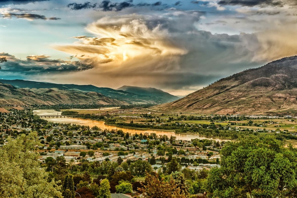
Kamloops is located at the southeast corner of the Fraser-Thompson Plateau area, and it is the largest city in the Thompson-Nicola Regional District. The city is situated at the confluence of two branches of the Thompson River.
Kamloops is a popular tourist destination because of its mild, dry climate. Additionally, the city is famously known as the Tournament Capital of Canada, hosting more than 100 sports tournaments annually.
While in Kamloops, there are over 50 accommodation choices to choose from and countless activities and events to enjoy. Some of the festivals and annual events in the city are the Kamloops Wine Festival, Kamloops Film Festival, River Beaver Classic mountain bike festival, and the Kamloops Comedy Fest. There are many more festivals for foodies, classic car enthusiasts, and outdoor recreationists, too.
Some of the popular hiking trails to look for while in Kamloops are the Tom Moore Trail, View of Kamloops Loop, Hoodoo Mara Mountain Connector, Kenna Cartwright Tower Trail, Mara Mountain Cliffs, Mara Loop, and the Isobel Lake Interpretive Trail.
Located at the junction of Highway 97 and Highway 20, the municipality of Williams Lake was originally established for its place at the crossroads of two pack trails leading to the Cariboo goldfields. The city is the second largest in the Cariboo Regional District, after Quesnel.

Williams Lake is famous for hosting the Williams Lake Rodeo, which is held annually on the Canada Day long weekend. The Williams Lake Rodeo is the second largest professional rodeo in Canada, after the Calgary Stampede. The city is located among the beautiful wilderness of the Fraser Plateau and there are many opportunities for outdoor recreation.
Some of the popular activities in the area are OHV use, horseback trail riding, fishing, canoeing, backpacking, fishing, and hiking. Some of the best trails of the area include: the Jenna Trail, Moose Drop Loop, Williams Lake River Valley Trail, Russet Bluff to Billy Goat Loop, and the Williams Lake River Valley Recreation Site Loop Trail.
The very descriptive name of 100 Mile House comes from the fact that during the Cariboo Gold Rush of the 1860s, a rest house was built 100 miles (160 km) up the Old Cariboo Road from Lillooet, which was located at Mile 0.
The primary industries at 100 Mile House are ranching, forestry, log home construction, and tourism. The region is gaining particular interest for its richness in bird life. Additionally there are hundreds of lakes in the area for boating and fishing. Plus, the surrounding wilderness is a particularly popular destination for hiking, cross country skiing, and OHV use.

Some of the popular hiking trails around 100 Mile House are Bridge Creek Falls, 100 Mile Marsh, 108 Mile Lake and Sepa Lake Loop, and the Walker Valley Greenway. Some of the provincial parks that are located nearby include Schoolhouse Lake Provincial Park and Wells Gray Provincial Park.


