
Scan the QR code and open PeakVisor on your phone
The Lac du Bois Grasslands Protected Area is located in the Thompson-Nicola Regional District of south-central British Columbia, Canada. The grasslands are situated on the Thompson Plateau, which is located to the west of the city of Kamloops. There are 6 named peaks within the protected area, the tallest of which is Opax Hill at 1,398 m (4,587 ft) in elevation and with 384 m (1,260 ft) of prominence.
Located on the Thompson Plateau of the Interior Plateaus of British Columbia, Canada, the Lac Du Bois Grasslands Protected Area encompasses five summits and unique grassland ecologies. The tallest and most prominent summit in the protected area is Opax Hill, with an elevation of 1,398 m (4,587 ft) and 384 m (1,260 ft) of prominence.
The Lac Du Bois Grasslands Protected Area is situated to the west of the city of Kamloops in the Thompson-Nicola Regional District. The protected area encompasses 157 square kilometers (60 square miles) of land and is accessible via several different routes, all of which lead to unique features and landscapes. The following are the primary access routes to the park:

Lac du Bois Grasslands Protected Area features a unique diversity of ecosystems in the Thompson-Nicola Regional District. The following are some the other parks and protected areas in the region:
The rough boundaries of the protected area are the South Thompson River and Kamloops Lake to the south and the North Thompson River to the east. The Bonaparte Plateau is the northern limit of the protected area and a rim of hills defines the eastern border. Additionally the Batchelor Range is located to the east, and both Mara Hill and Battle Bluff are situated to the south.
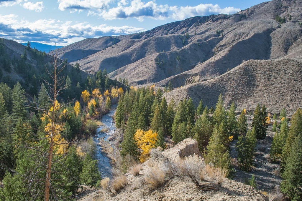
Lac du Bois Protected area has a variety of interesting landscape features. The ages of the rocks of the park span about 200 million years of geologic time where processes like accumulation, accretion, volcanic activity, mountain formation, and glacial erosion created the park as we see it today.
The bedrock of the park is composed of volcanic and sedimentary rocks from the Triassic. About 50 million years later, the Cherry Creek pluton and Iron Mask batholiths intruded into the Battle Bluff area of the park.
A further 100 million years would pass until the extensive basalt and dacite lavas and the 45-million-year-old sedimentary rocks of the Eocene and Oligocene were added to the terrane. The lavas form Opax Hill, Mount Wheeler, and the highest parts of Mara Hill; however, the most striking examples of these lava flows are found on the high cliffs of the Dew Drop area.

After these final lava flows were deposited to create the vast stretches of the Thompson Plateau, the crust cracked and split apart. The Thompson valleys, including Kamloops Lake, split apart, even splitting the Cherry Bluff pluton so that it is found on either side of the lake.
With the onset of the Pleistocene, Lac du Bois Grasslands Protected Area was covered extensively by the cordilleran ice sheet. Much of the eastern landscape of the park was created by the repeated advance and retreat of the ancient glaciers.
Glacial till makes up most of the surface deposits across the park. As such, there are drumlin-like formations in the park as well as significant esker formations at Pruden Pass and to the west of Long Lake. Some of the lakes, ponds, and wetlands in the eastern part of the park were formed from kettle holes when the ice retreated around 15,000 years ago.
The Lac du Bois Grasslands Protected Area of the Thompson Plateau is represented by three of the major ecological zones of British Columbia, including the Interior Douglas Fir Zone, Ponderosa Pine Zone, and the Bunchgrass Zone. These zones all represent the driest and hottest climates in British Columbia.
The Bunchgrass Zone comprises the grasslands for which the protected area was named. The lowest elevations of the valleys are the hottest and driest and have clumps of bluebunch wheatgrass, big sagebrush, and a variety of early spring blooming plants. Between the grasses and plants is a thin layer of lichens and mosses which form a cryptogamic crust to help prevent erosion.

The area historically had extensive areas of black birch; however, much of it was cleared to graze cattle and now willows and black birch tend to only grow along the creeks and rivers.
Plants in the area include needle-and-thread grass, crested wheatgrass, Canada bluegrass, arrow-leaved balsamroot, nodding onion, Thompson's paintbrush, mariposa lily, prickly-pear cactus on drier sites, and aspen on moister soils.
The narrow band of ponderosa pine forests in Lac du Bois Grasslands Protected Area is located at the northern limits of the ponderosa pine habitat.
Here, these trees are also well-mixed with stands of Douglas fir. The area is a mosaic of open stands of ponderosa pine and fir, thickets of dense trees, and grasslands of bluebunch wheatgrass, rough fescue, big sage, rabbit brush, yarrow, and pasture sage.
The Interior Douglas Fir Zone is a mosaic of Douglas fir–dominated forests and grasslands of rough fescue, Columbia needlegrass, Kentucky bluegrass, Junegrass and bluebunch wheatgrass. Arrow-leaved balsamroot occurs in some areas, as do chocolate lily, larkspur, sticky geranium, death camas and the umbrella plant.

The grassland and hills of the Lac du Bois Grasslands Protected Area have a wide variety of animal species. Deer inhabit the forests and open slopes of Opax Hill, Mount Wheeler, and Mara Hill while California bighorn sheep inhabit the Dewdrop area. The sheep prefer the steep canyon terrain, as well as other cliffs, rocky outcrops, and steep slopes that they can use for escape.
Coyotes wander through the park alone or as part of a family group and red foxes haunt the valleys. Black bears inhabit the higher elevations of the park and weasels are found in the creek valleys. Bobcats and cougars are difficult to see in the park; however, they are a key component of the ecology. Other mammals that can be found in the area are river otters, beavers, muskrats, moose, squirrels, chipmunks, mice, shrews, and voles.
The Thompson River estuary is a biologically important area for birds with almost 50% of all bird species found in British Columbia having been seen at the estuary at one point or another.
Some of the rare species that have been seen in the protected area are the burrowing owl, prairie falcon, brewer's sparrow, peregrine falcon, flammulated owl, sharp-tailed grouse, Lewis’ woodpecker, long-billed curlew, and white-throated swift.

The wide variety of habitats found in Lac du Bois Grasslands Protected Area are responsible for the vast variety of bird species in the region. The grasslands are home to the vesper sparrow, meadowlark, killdeer, and the American kestrel, while the wetlands are home to mallards, redhead, Barrow’s goldeneye, and many other waterfowl.
The transitional areas between the forests, grasslands, and wetlands are unique habitats that many bird species, such as swallows, warblers, finches, thrushes, and sparrows, prefer. Woodpeckers, owls, hawks, and falcons find their prey among the grasslands and forests. Geese, tundra swans and many other rare and unusual species are recorded as visitors in the protected area as well.
The Shuswap of the Interior Salish culture have inhabited the Lac du Bois Grasslands Protected Area for thousands of years, using the grasslands and forests for hunting and gathering natural resources for food, clothing, tools, and medicine.
Battle Bluff is one of the most important cultural sites in the protected area. The name is a translation from the original Shuswap name for the location that commemorates a major battle in the history of the region. Fur traders arriving in the eighteenth century were the first peoples of European descent to travel the grasslands and use the region’s resources.

By the 1820s, the Hudson’s Bay Company was using the grasslands to pasture their horses. At one point, there were upwards of 700 horses living on the grasslands. As many of the early fur traders were French, French names were commonly assigned to many of the features of the region, such as Lac du Bois.
The present-day Frederick Road follows the 1842 Hudson’s Brigade trail as the Brigade left the Thompson area for the Cariboo region in the north. While the fur trade was successful throughout the first half of the nineteenth century, settlement was slow until an influx of settlers arrived with the discovery of gold in the Fraser River in 1858.
Homesteaders and ranchers arrived in the region and started to settle the area, forming the basis of the city of Kamloops and other communities in the region. The homesteaders began to face hardships in the first decades of the twentieth century as drought conditions settled into the region.
Most evidence of the early homesteads has been removed from the grasslands; however, the occasional fruit tree and ornamental plant may be seen by observant visitors to the park.
While farming faltered in the early 1900s, the ranching legacy of the region began to take shape, such that ranchers grazed their herds of cattle, horses, and sheep in the Lac du Bois grasslands. The grasslands are still used for cattle grazing as well as research into the grasslands ecology. Much of this research centers on how to create a sustainable ecosystem while also allowing for ranching and similar types of land use.
The early twentieth century saw logging and milling operations come and go, as well as small placer gold claims. Early forestry efforts saw the removal of the easily accessible old growth Douglas firs, many of which were over 400 years old.
Since settlers first came to the region in the early nineteenth century, the grasslands were seen as a place to hike and travel by horseback for recreation. The lack of natural water resources and the need to carry plenty of water during these outings was noted early in the history of the region.
The grasslands still provide significant recreation opportunities for visitors. They are home to a diversity of terrain and ecosystems that visitors can hike though and enjoy.
The Lac du Bois Grasslands Protected Area envelopes a variety of fascinating wilderness terrains, habitats, and ecosystems. The following are some of the popular hikes and attractions that are found in the protected area.
The 3.5 km (2.1 mi) long, interpretive Mara Trail overlooks Kamloops Lake and the Thompson River. As it follows rolling hills and ridges, the trail is moderately difficult. Along the way, you can look for the different plants that inhabit this area such as the Douglas fir, ponderosa pine, and aspen trees, as well as assorted grasses, sagebrush, and a variety of cacti.

The Cinnamon Ridge Trail ascends a ridge and part of Mara Hill among grasslands and desert landscape. The 4.25 km (2.5 mi) long trail is considered moderate to hard due to the hills along the trail. One of the main features of this trail are the hoodoos that are a fascinating testament of the erosive powers of water and wind.

The Dewdrop Trail is a 5.7 km (3.4 mi) steep climb that reaches viewpoints overlooking Kamloops Lake and the valley. California bighorn sheep inhabit the area of this trail, and you may be fortunate to catch a glimpse of them roaming the rocky outcrops and ridges.

The Grasslands Community Trail is a 13 km (7.8 mi), one-way trail that winds through all three grasslands ecosystems. The trail is popular for cyclists, trail runners, horseback riders, and hikers. In addition to experiencing the various grasslands ecosystems, the trail passes by Deep Lake, which has rainbow and brook trout for visitors who would like to test their luck, skill, and patience with angling.
Lac du Bois Grasslands is located on the north side of the Thompson River in the Thompson-Nicola Regional District. The following are the cities that can serve as a great base for your adventures to the protected area.
Kamloops is the capital of the Thompson-Nicola Regional District. Referred to as the Tournament Capital of Canada, Kamloops has built impressive infrastructure to attract over 100 annual sporting tournaments to the city.
While in the city for a tournament, visiting friends or family, or simply coming to experience the unique wilderness of the Thompson Plateau, Kamloops has many attractions and annual events. There are food and wine festivals every year, along with film and comedy festivals, car shows, and weekends dedicated to mountain biking culture.
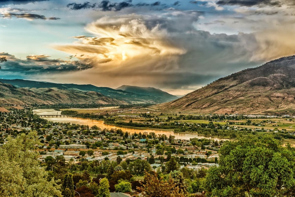
Additionally, for those that want to walk along a peaceful river pathway, or see the plateau from a nearby peak, there are many wilderness areas to explore and hike. Some of the nearby hiking areas are the Lac du Bois Grasslands Protected Area, Kenna Cartwright Nature Park, Paul Lake Provincial Park, Porcupine Meadows Provincial Park, Greenstone Mountain Provincial Park, and Mount Savona Provincial Park.
Merritt is located at the confluence of the Nicola and Clearwater Rivers at the central part of the Thompson Plateau. For hundreds of years, the townsite and surrounding grasslands have been a meeting place for settlers and First Nations.
As traders, explorers, and settlers started crossing the region, the Merritt area became a junction for many of the trails the pioneers travelled. By the middle of the eighteenth century, the grasslands around Merritt drew the attention of settlers interested in ranching and large ranching operations were set up around the area.

Some hikes that are located around Merritt are the Coldwater River Trail, Iron Mountain Loop, Tom Lacey Trail, Godey Creek Trail, and Lone Pine Loop. Some of the nearby recreational opportunities also include mountain biking areas, such as Coutlee Mountain Bike Trails Recreation Site and Sugarloaf Mountain Bike Trail Recreation Site.


