
Scan the QR code and open PeakVisor on your phone
Nestled in a forest of Douglas fir and aspen in central British Columbia, Canada, Paul Lake Provincial Park is a popular destination for families and those looking for a relaxing time aside one of the province’s beautiful lakes. Gibraltar Rock is the tallest point in the park, with an elevation of 956 m (3,136 ft), and from the summit visitors can gaze upon the lake and nearby Mount Harper.
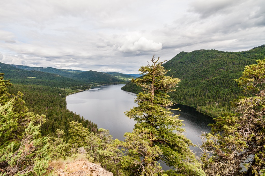
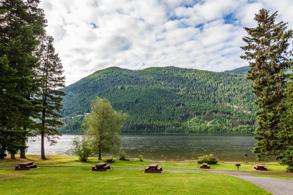
Paul Lake Provincial Park is in the Thompson-Nicola Regional District of central British Columbia, Canada. Gibraltar Rock (956 m/3,136 ft) overlooks Paul Lake and the serene Douglas fir and aspen forest that carpets the valley and slopes.
The park is about a 30-minute drive from the nearby city of Kamloops and is accessed by following Highway 5 north of Kamloops for about 5 km (3 mi) and then taking the paved Pinantan Road for 19 km (11.4 mi) to the campground. The park has nearly 100 vehicle-accessible campsites and a site for group camping as well.
The park is a popular destination for locals looking to get away from the city for a weekend and for regional visitors who want to spend some relaxing time camping by a beautiful lake. Paul Lake Provincial Park is one of many parks in the region that were established to create opportunities for locals to engage in wilderness recreation.
There are many parks in the region, and some are more accessible than others. Paul Lake Provincial Park is certainly geared towards family camping; however, there are options for more remote wilderness excursions as well. The following are some of the other wilderness parks which can provide more opportunities for relaxation or adventure.
The geology of British Columbia is complex as there were many stages to the formation of the province. Paul Lake Provincial Park is situated upon the Thompson Plateau, which is the southernmost of the three major interior plateaus.
East of Paul Lake Provincial Park, the land rises and is called the Shuswap Highlands, which are a transition area between the relatively low-lying plateaus and the Columbia Mountains, which are west of the Shuswap Highlands.
About 200 million years ago, most of the province of British Columbia did not exist as part of North America. At this time, the continental margin was approximately where the Canadian Rockies now lie. However, starting about 185 million years ago, exotic terranes, island arcs and microcontinents which formed in the Pacific Ocean began colliding with and accreting to North America.
In the south end of British Columbia, the Columbia Mountains were the first to form as outboard terranes collided with the continental margin. Terranes were colliding with the west coast because North America was slowly moving west, overriding the tectonic plates under the Pacific Ocean.
As the oceanic plates subducted beneath the continent, the rocks of the west coast were compressed, added to, folded, and uplifted. Furthermore, the subduction zones were subject to volcanic activity, which is how the interior plateaus, such as the Thompson Plateau where Paul Lake Provincial Park sits, formed.
As discussed, the underlying rocks of Paul Lake Provincial Park and the Thompson Plateau originated in the Pacific Ocean and were accreted to the continent during the Mesozoic. The subduction zone was volcanically active, and the region was pervasively intruded by magma which cooled to form granitic rocks.
Volcanism occurred across the interior of British Columbia, primarily as a field of overlapping volcanic vents starting as early as the Oligocene. The region of the Thompson Plateau was covered by thin sheets of plateau basalt that flowed from volcanic vents between ten and fifteen million years ago.
During the Pleistocene, the plateau was covered by an ice sheet, which may have been several kilometers thick in some areas. As the ice sheet moved along it eroded massive amounts of the underlying surface and as the ice melted, the plateau was covered with a thick veneer of glacial till.
The summers around Paul Lake are warm, short, and dry while the winters are cool, with most of the precipitation falling at higher elevations. The ecology reflects the lack of moisture in the region which is due to the rain-shadow cast by the Coast Mountains and Cascade Mountains.
The forests around Paul Lake are a mix of aspen, pine, and Douglas-fir, with wild rose bushes commonly found in the understory around the campground. The aspens are the deciduous, or leafy, trees around the lake. They have a light colored, almost white bark; however, unlike birch, the bark doesn’t easily peel off.
The Douglas-fir are typically among the largest trees in the forest with short needles on their branches and a thick bark, which helps make them resistant to grass fires that commonly burn through their habitat. The easiest way to know if you’re looking at a Douglas fir is to examine the pinecones, which have little beard-like protrusions from between the scales.
Lodgepole pine and ponderosa pine are the other trees around Paul Lake Provincial Park that you are likely to encounter. Lodgepole pine trees are usually the first trees to grow after a forest fire, and they typically are relatively slender, straight trees with most of their branches concentrated towards the top.
The ponderosa pine are long-needled, thick-barked trees with magnificent pine cones. Like the Douglas fir, the bark of the ponderosa pine is thick to resist burning when grass fires occur.
While Paul Lake Provincial Park is too small to contain the entire range of any large animal, there are many that may come and visit while you’re camping or visiting the park. Mule deer are the most likely mammal that you’ll spy while visiting the park; however, elk may also wander through. Bears are not as common in the area; however, they are certainly around and are attracted to easy food, so be aware.
Some of the at-risk species that you may have the opportunity to see in the park are the great blue heron, American bittern, and the painted turtle and perhaps you’ll be lucky enough to see one of the flammulated owls that have returned for the summer from Mexico.
There is evidence that people have inhabited the Thompson Plateau for the past 10,000 years, typically as hunter-gatherer societies. These people hunted the elk and deer from the meadows and stalked mountain goats and bighorn sheep in the mountains.
The land provided an abundance of berries, roots, and other edible plants as well as all that was needed for their clothing, tools, and homes. However, around 4,000 years ago, there was a change occurring and the original inhabitants were struggling to adapt to their changing environment.
However, around this time, new groups of people started migrating from the west coast to establish themselves in the interior of British Columbia. Having branched from the Coast Salish, to become known generally as the Interior Salish, these new inhabitants upon the plateaus brought with them generations of knowledge, such as fishing, which helped them overcome the changing environmental conditions.
Paul Lake Provincial Park is in the traditional territory of the Secwepemcúl’ecw (Secwépemc), who have also been referred to as the Shuswap people in English. They are an Interior Salish people who once roamed from the eastern Chilcotin Ranges and the Cariboo Plateau, across the Thompson Plateau and Selkirk Mountains to the Columbia Valley.
The Secwépemc relied upon hunting, fishing, and trading for their general sustenance and survival. Some of their cultural characteristics are raiding, potlatching, and stewardship of natural resources. Indeed, they had a complex society and a hierarchy that laid out rules for where families could hunt and gather resources and their roles in conflicts.
While there is no specific evidence that Paul Lake played a major role in the Secwépemc culture, more than likely individuals and families hunted nearby, came to the lake to gather resources, or participate in cultural or spiritual activities.
During the nineteenth century fur traders and settlers were coming to the region, upsetting the lifestyle of the Secwépemc. Disease ripped through indigenous communities and settlers came to inhabit the land. Forestry, ranching, and trapping were the major industries during the early settlement of the area.
During the twentieth century, government officials were looking for places to create parks where locals could enjoy the wilderness and outdoor recreation. Paul Lake Provincial Park was established in 1961, with 402 hectares (993 acres) of wilderness surrounding Paul Lake. In 1996 an additional 268 hectares (662 acres) of Douglas fir forest was added to the park, including stands of old growth.
Today the park is enjoyed by families from the Kamloops area as well as by visitors from further abroad. The park offers a wonderful opportunity to camp alongside a beautiful lake and enjoy wilderness and outdoor activities such as paddling, swimming, hiking, and cycling.
Paul Lake Provincial Park has a beautiful lake in a wilderness setting, and it’s close to Kamloops. Most visitors are locals who come to the park for a weekend or perhaps even a week of well-deserved wilderness-oriented relaxation.
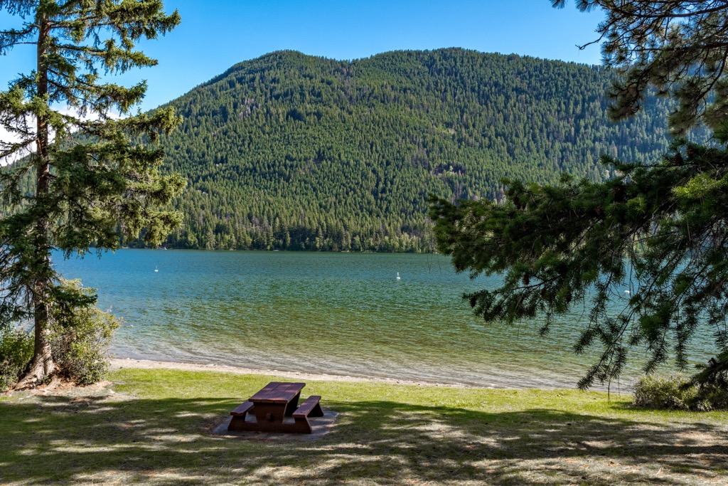
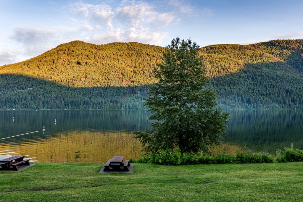
Paddling a canoe, kayak, or a SUP are popular activities upon the lake. The lake is also stocked with a couple different types of rainbow trout for the anglers who visit. Furthermore, the lake is great for swimming, and there is a 400 m (1,300 ft) sandy beach that is perfect for playing games, resting, and picnicking.
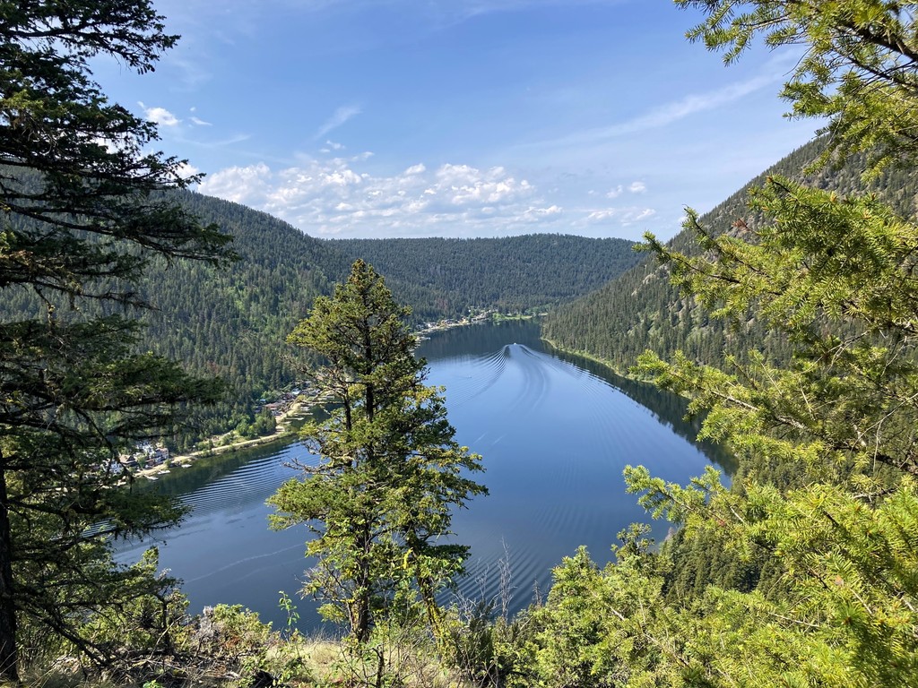
There are about 7 km (4.2 mi) of trail in the park, where the major hiking attraction is the summit of Gibraltar Rock. The final approach to the summit is steep; however, there are opportunities for resting along the trail. Furthermore, there are steep cliffs along the trail and care should be taken when hiking, especially with young children to ensure their safety.
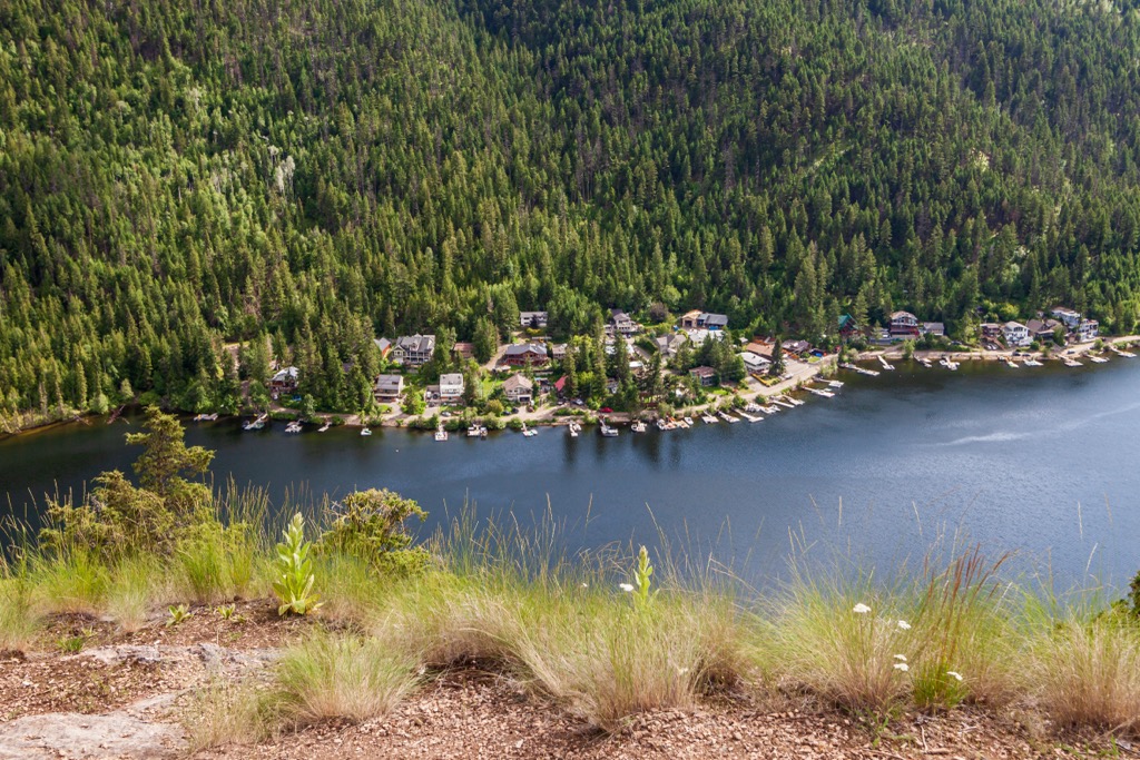
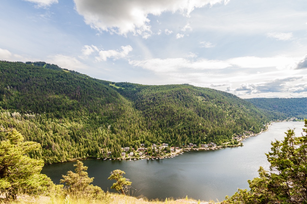
From the summit of Gibraltar Rock, hikers get a wonderful view of Paul Lake and nearby mountains, such as Mount Harper and Rockface Mountain. The trailhead is in the parking lot by the beach; however, hikers can follow a different trail which leaves from the campground, or even follow it as a loop.
Along with swimming, boating, fishing, and hiking, the trails around the park are great for cycling, even for families, and there is also a wonderful playground for the children. Another family friendly activity is the Learn to Fish Program that is hosted at the park which teaches basic fishing skills to youth under 16 years old.
The easy-going trails are also accessible in the winter and provide an accessible location to try snowshoeing or cross-country skiing. While the gates to the park are open in the winter, there are no winter facilities available.
BC Parks has over 1,000 different sites as part of their portfolio of wilderness conservation and recreation areas. Paul Lake Provincial Park was established as a wilderness site for locals to enjoy the lake and camping; however, it is also a great spot for traveling visitors to spend a night or two while traversing the beautiful province. The following are the major cities and communities near the park:
Situated upon the Thompson Plateau, Kamloops was established at the confluence of the North and South Thompson Rivers. The city has a population of about 100,000 people and it has grown from a fur trading post for the Pacific Fur Company to the “Tournament Capital of Canada”.
David Stuart was the first recorded European to arrive in the area that would become Kamloops, in 1811. He was sent as a liaison of the Pacific Fur Company to spend the winter with the Secwépemc, after which Alexander Ross established “Fort Cumcloups”.

The city of Kamloops was incorporated in 1893, with a population of about 500 people. The city and region have a rich history which is filled with big personalities, wars, gold rushes, pandemics, and conspiracy. Many of the visitors come to participate in the tournaments; however, once in Kamloops, there are lots of activities to choose from.
There are museums, art exhibits, as well as car shows and wine tasting events. The city hosts film festivals as well as many tournaments for hockey, baseball, golf, and other sports. To take a break from the city or the events, there are a lot of nearby wilderness areas to enjoy, such as Kenna Cartwright Nature Park and Lac Du Bois Grasslands Protected Area.
About 100 km (60 mi) west of Paul Lake Provincial Park, Salmon Arm is one of the major communities of the lake area of the Columbia-Shuswap Regional District. The city takes its name from its location upon the Salmon Arm, which is one of the four major arms of the Shuswap Lake.
The modern history of the city starts with the railway which was laid through the area in 1885. The railway brought miners, businessmen, and settlers who quickly recognized the fruit growing potential and were quick to profit from exporting fruit to surrounding communities. However, the tourist potential of the wonderful beaches and the lake remained untapped for decades.
In time, people from as far away Vancouver and Calgary came to regard the Shuswap as a wonderful place to vacation. The summertime population of Salmon Arm and the lake district booms in the summer, as visitors come to their vacation homes on the lake, for camping, or to spend a week on a houseboat.

Water and lakeside activities dominate the summer culture of the city; however, there is also a thriving folk music scene that started in the 1970s and there is now the annual Roots & Blues festival. Other local attractions include theaters, a museum, and a public art gallery.
There are also many parks and wilderness areas around salmon arm that offer opportunities for day hikes or even extended backpacking excursions. Some of the nearby hiking areas are Enderby Cliffs Provincial Park, Monashee Provincial Park, and Silver Star Provincial Park. Salmon Arm is also not too far from Mount Revelstoke National Park and Glacier National Park.


