
Scan the QR code and open PeakVisor on your phone
Located in the Thompson Nicola Regional District of British Columbia, Canada, Greenstone Mountain Provincial Park encompasses some of the highest terrain in the region. The park’s namesake Greenstone Mountain rises 1,797 m (5,896 ft) above sea level and has 324 m (1063 ft) of prominence. Thanks to the road that leads to its summit, Greenstone Mountain is one of the easiest peaks to climb in the region.
Situated near the city of Kamloops, in British Columbia, Canada, Greenstone Mountain Provincial Park encompasses one of the tallest peaks in the region.
Greenstone Mountain is the only peak in the park and has 1,797 m (5,896 ft) of elevation and 324 m (1063 ft) of prominence; however, there is a road to the peak, which makes it a very easy peak to summit.
Situated upon the Nicola Plateau, in the Thompson Nicola Regional District, Greenstone Mountain looks over the adjacent plateaus and mountain ranges of the Thompson Plateau.
The park was designated in 1997 to preserve a small, accessible, subalpine area near Kamloops for recreational pursuits. The park is located adjacent to and has areas of logging and grazing leases.
Some of the other provincial parks and protected areas near Greenstone Mountain Provincial Park include:

Greenstone Mountain is underlain by mafic and intermediate volcanic rocks of the Nicola Group and is within the Nicola Volcanic Belt. The Nicola Volcanic Belt is filled with deposits of gold, copper, and other minerals and metals that have led to prospecting and mineral exploration of the area and park for over 120 years.
The major rocks present in Greenstone Mountain Provincial Park are part of Quesnellia, which is a volcanic arc that formed in the Pacific during the Triassic and Jurassic periods of the Mesozoic.
The island arc floated on tectonic plates that were located under the Pacific Ocean. When the oceanic plates collided with North America, the Quesnel Terrane was added to the continental landmass.

When tectonic plates subduct and exotic terranes accrete to continental margins, such as what happened when Quesnellia accreted to the edge of North America, the region around this accretion generally sees an increase in volcanic activity. Indeed, the Nicola Group of rocks, which underlie Greenstone Mountain, were intruded by alkaline plutons and calc-alkaline intrusive rocks during volcanic events starting in the late Jurassic.
The main rocks of the park are diorite and quartz monzonite with areas of intrusive breccia. Breccia is a conglomerate of angular gravel and boulder-sized clasts cemented together. Additionally, the clasts and fragments found in breccia generally have sharp edges, signifying that they have not moved far to arrive in their current location.
Greenstone Mountain Provincial Park was designated to preserve a small and accessible subalpine area near Kamloops, British Columbia. Greenstone Mountain was chosen for the park because it features an uncommon high elevation grassland. Additionally, Greenstone Mountain is the most northerly and highest elevation location that’s home to Vasey’s big sagebrush.
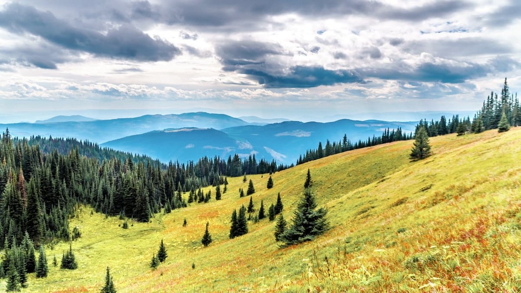
The grassland in the park is filled with fescue, Bluebunch wheatgrass, forbes, and wildflowers. Additionally, this grassland is bordered by forests of Douglas fir, lodgepole pine, spruce, subalpine, fir, and aspen.
The ecology toward the summit of the peak is representative of the Engelmann Spruce–Subalpine Fir ecosystem. Meanwhile, the lower slopes are representative of the Montane Spruce ecosystem.
Greenstone Mountain Provincial Park is located in the traditional territory of the Nlakapamux and the Secwépemc. While there are no publicly recorded archeological sites within the park, the region has been inhabited by people for at least the past 10,000 years.
During the lengthy habitation of the region, it is likely that members of the various cultures found reason to summit the second tallest mountain in the region. Even if First Nations didn’t summit the peak for hunting or gathering, perhaps, like George Mallory regarding his attempt to climb Mount Everest, they climbed it “because it was there.”
The First Nations had been living in the region for countless generations before fur traders arrived in 1811 to establish trading routes. The first European fort was built in 1812. This fort brought prospectors during the gold rush and was later the established starting point for homesteaders coming to the region in the latter half of the nineteenth century.

With the promise of a railway, British Columbia joined Canada in 1871. By 1883, the railway had arrived at Kamloops. While the gold rush didn’t pan out, there are several gold mines in the region as well as copper and other metals and minerals. Many of the unsuccessful miners turned their hands to homesteading and started the ranching in the region.
Currently, both in and around the park there have been and are logging and grazing leases. There are mines near the park and prospecting has occurred on the mountain for the past 120 years; however, there are no active mines in the park.
Greenstone Mountain Provincial Park is a small park that was established with the very specific purpose of preserving accessible subalpine wilderness for recreational use.
The park is situated on the upper slopes of the mountain. It contains the lookout at the peak, however the trails located along the lower slopes are not part of the park.
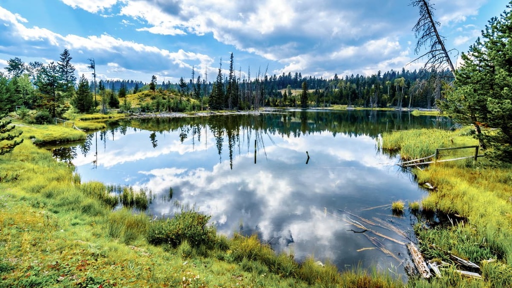
The summit of Greenstone Mountain is home to a refurbished lookout, which offers incredible views of the surrounding hills, lakes, and valleys of the Thompson Plateau. Birdwatching, hiking, horseback riding, snowshoeing, snowmobiling, mountain biking are all popular activities in the park.
There are several unofficial hiking trails on the mountain, and the most popular hiking trail is likely the trail that travels under the power lines.
Many visitors come to Greenstone Mountain to access some of the incredible downhill trails that have been created by local clubs. Many of the downhill trails intersect with the motorcycle trails, so care should be taken while traveling to avoid collisions.

Greenstone Mountain Provincial Park is an accessible, subalpine wilderness park, which was created for the recreational use of the inhabitants of Kamloops and the surrounding area. The following are some of the cities near Greenstone Mountain that can provide services to further your wilderness adventures:
Kamloops is known as the Tournament Capital of Canada, as it hosts over 100 sports tournaments annually. Located only 36 km (22 mi) north of Greenstone Mountain Provincial Park, the park was created to preserve a wilderness recreation area near the city.
Tourism is a major industry in the city. In addition to hosting tournaments, the city is also host to film and wine festivals, mountain bike festivals, car shows, art shows, comedy fests. There is also an annual rib fest as well as other conventions and festivals.
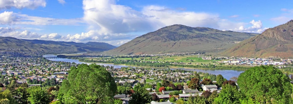
While the city of Kamloops works hard to create events to draw in tourists, the city is surrounded by an incredible wilderness area that has panoramic vistas, areas rich with ancient history, and opportunities for incredible wilderness adventures.
Some of the best hiking areas near Kamloops include the Kenna Cartwright Nature Park, Lac du Bois Grasslands Protected Area, Greenstone Mountain Provincial Park, and Mount Savona Provincial Park. With road access to the top of Greenstone Mountain, Kamloops is an ideal location to take in the view of the surrounding plateau.
Merritt is a community that’s located centrally on the Thompson Plateau, about 80 km (64 mi) to the south of Greenstone Mountain Provincial Park. Situated at the confluence of the Nicola and Clearwater Rivers, the townsite and surrounding grasslands have been a meeting place for settlers and First Nations for hundreds of years.

By the middle of the eighteenth century, the grasslands around Merritt drew the attention of settlers who were interested in ranching. As traders and settlers started visiting the region, the Merritt area became a junction for many major trails. Large ranching operations were set up around the area.
Merritt is located upon the stunning Thompson Plateau and is situated near some incredible wilderness areas. Some hikes to look for while passing through or staying in Merritt are the Coldwater River Trail, Iron Mountain Loop, Tom Lacey Trail, Godey Creek Trail, and Lone Pine Loop.


