
Scan the QR code and open PeakVisor on your phone
Humboldt National Forest has 181 named peaks. The highest is Mount Moriah at 3,677 m. Other notable peaks include North Schell Peak, South Schell Peak and Taft Peak.
The Humboldt National Forest is an expansive outdoor recreation destination located in the northern and eastern regions of the US state of Nevada. Together with the Toiyabe National Forest, it forms the largest national forest in the contiguous US. There are 181 named mountains within the forest, the highest of which is Mount Moriah at 12,064 ft (3,677 m) in elevation and the most prominent of which is North Schell Peak with 5,430 ft (1,655 m) of prominence.
The Humboldt National Forest, together with the Toiyabe National Forest, spans 6.2 million acres (2,545,500 ha). The Humboldt region consists of numerous non-contiguous sections that span across northern and eastern Nevada.
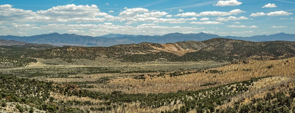
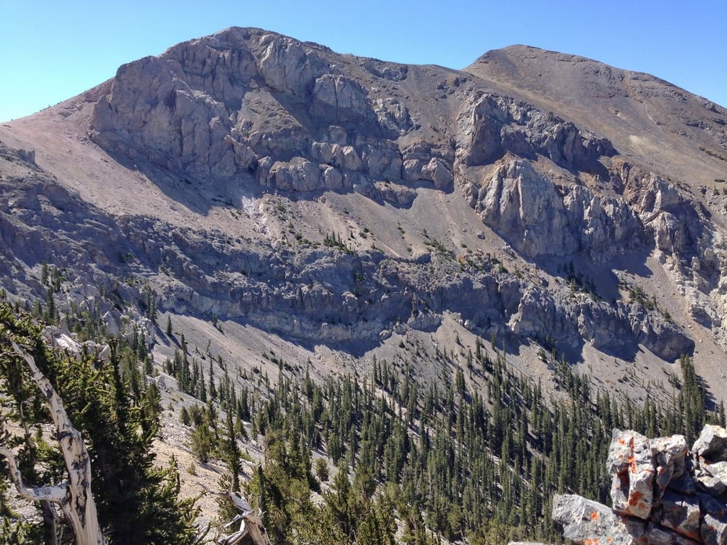
All portions of the forest lie within the Basin and Range Province of the southwestern United States. The rugged landscape is marked by some of Nevada’s most prominent ranges such as the Ruby Mountains, Humboldt Range, and the Snake Range.
The Humboldt National Forest section is located in five Nevada counties: Elko, White Pine, Nye, Humboldt, and Lincoln. Together, these portions cover approximately 2.6 million acres (1,052,500 ha) of land.
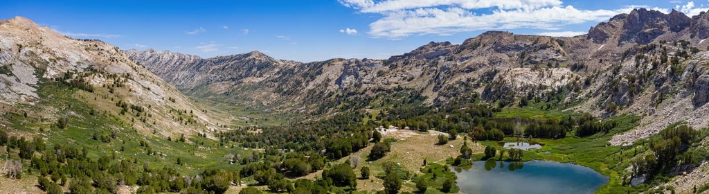
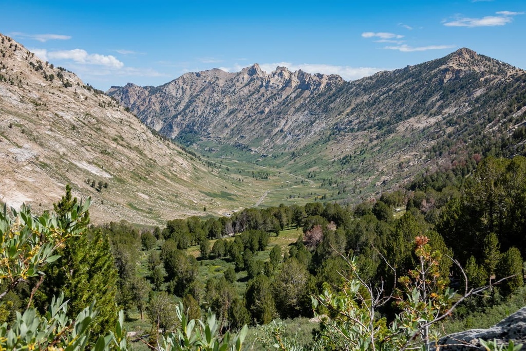
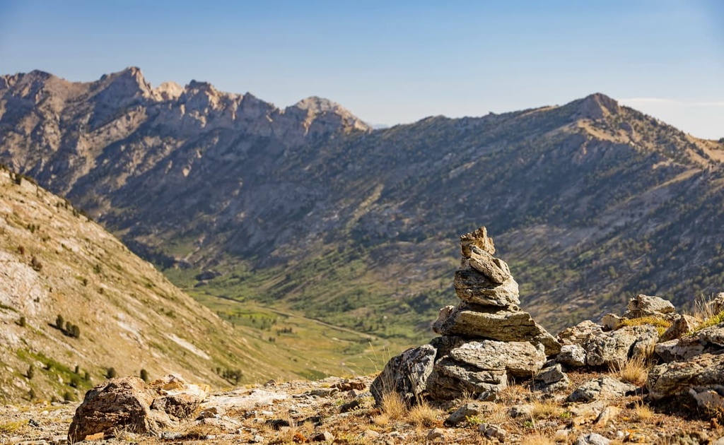
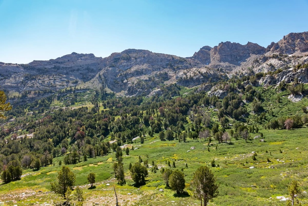
Much of the landscape is marked by rolling foothills that give way to rugged and often barren peaks. The north to south-running ridges of the national forest are separated by wide sweeping valleys. Prominent canyons include Lamoille, Box, Seitz, Kleckner, and Silver Creek.
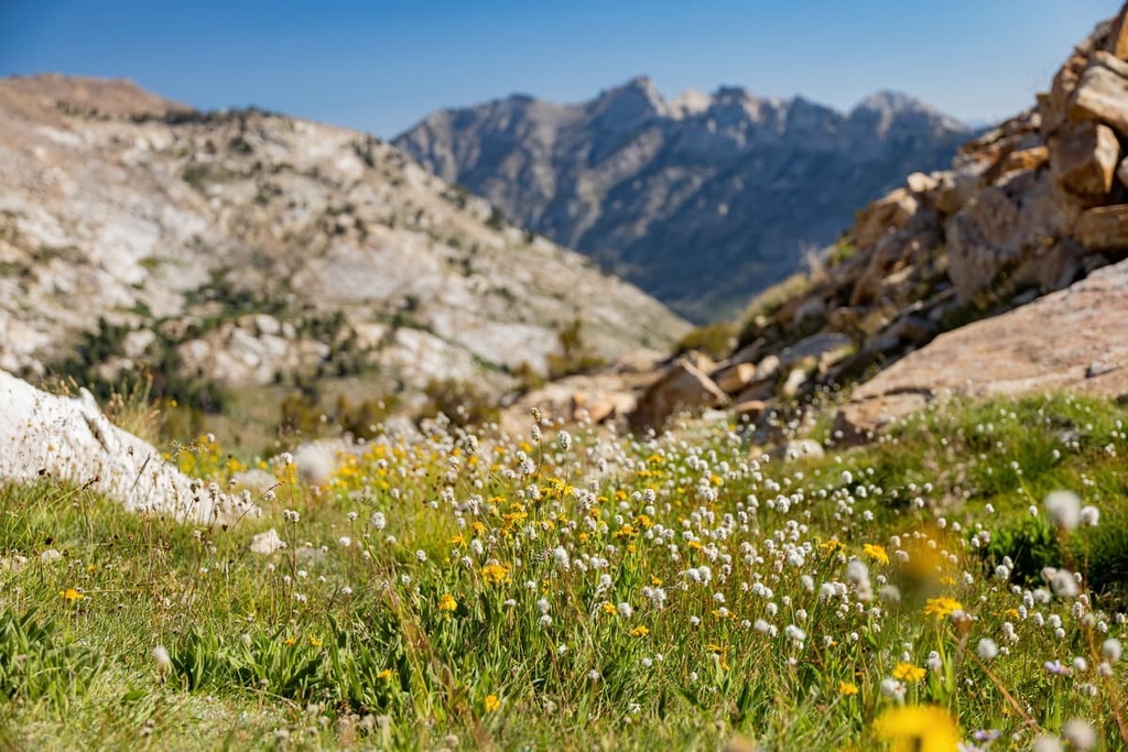
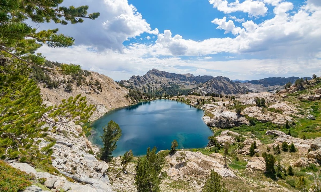
The Humboldt River cuts across the region in an east to west direction before traveling southwest to Humboldt Sink. Lower elevations in the forest are often drier than the higher elevations, and, as such, they are home to minimal plant life. Higher elevations in the Ruby Mountains are home to alpine lakes, which have been left behind by the once-massive glaciers that covered the Basin and Ranges region during the last glacial maximum.
The Humboldt National Forest is home to numerous wilderness areas. These include:
Humboldt National Forest is also situated near numerous other areas for outdoor recreation. In particular, Toiyabe National Forest lies to the southwest of Humboldt while Great Basin National Park is located to the south, Dixie National Forest is located to the southeast, and the Bonneville Salt Flats are situated to the east.
The peaks within the Humboldt National Forest are part of the larger Great Basin Ranges, which extend throughout much of Nevada, Utah, Idaho, Oregon, and California.
The major subranges found throughout the forest include the Ruby Mountains, Humboldt Range, and the Snake Range. The entire region was created due to tectonic extension, which stretched and folded the landscape into what we see today. This extension of the North American plate led to the creation of distinct mountain ranges and basins, which is how the Basin and Range Province got its name.
Faults lie on the eastern and western sides of the ranges, giving each range its distinct geological structure. Many subranges in the region, such as the Ruby Mountains, consist of a metamorphic core complex.
The tectonic extension that formed the ranges within the forest dates back to the Early Miocene. Continual erosion and glacial retreat further carved out the landscape that we see to this day.
A mixture of both igneous and metamorphic rocks can be found in the core of the ranges in Humboldt National Forest. Meanwhile, the outer layers of rock in the national forest are often sedimentary in origin.
The subranges in the southern portion of the forest generally feature more drastic changes in elevation compared to those in the north. A variety of minerals can be found throughout northern and eastern Nevada.
Major peaks within the Humboldt National Forest include Mount Moriah, North Schell Peak, Hole in the Mountain Peak, Ruby Dome, Troy Peak, and Matterhorn (not to be confused with the Matterhorn in the Alps).
Due to the sheer size and topography of the Humboldt National Forest, the region is able to support a wide range of both flora and fauna.
Lower elevations in the forest are primarily dominated by pinyon pine and juniper trees. Higher elevations feature forests of mountain mahogany, white fir, Douglas fir, aspen, limber pine, and bristlecone pine.
Other common tree species in the region include quaking aspen, Engelmann spruce, and limber pine. Whitebark and limber pine trees tend to thrive in regions that experience minimal rainfall, particularly where other tree species wouldn’t survive.
The highest elevations in the forest are often free of trees, instead providing the ideal conditions for low growing grasses and wildflowers. A variety of wildflowers grow in Humboldt National Forest, including paintbrushes, globe mallows, balsamroots, buckwheats, chokeberries, and thistles.
The Humboldt-Toiyabe National Forest provides the ideal habitat for over 100 threatened, endangered and sensitive animal species.
Common mammals spotted in the forest are mule deer, Rocky Mountain bighorn sheep, mountain lion, and elk. Populations of mountain quail, chukar, blue grouse, and sage grouse are also common throughout the forest. The perennial streams of the region are home to rainbow, cutthroat, brown, and brook trout.
Present-day Nevada has a long and rich history of human habitation that dates back thousands of years before the arrival of European settlers. Archaeological evidence and cultural knowledge suggests that humans have lived in the region over 10,000 years.
Many Indigneous communities have lived on the land surrounding Humboldt National Forest since time immemorial. Some of the most prominent tribal nations with ancestral ties to the region include the Western Shoshone, Northern Paiute, and the descendants of the Ancestral Puebloans.
Historically, members of these tribes covered a vast region of land that they frequently migrated across for hunting and gathering purposes.
The Northern Paiute traditionally lived a nomadic lifestyle, often migrating with the seasons and living at lower elevations during the winter months. Relations between the Northern Paiute and Western Shoshone tribes were primarily peaceful and the two Tribes share similar languages and traditions.
It is estimated that the region’s Tribal Nations first made contact with settlers of European descent during the 1820s. By the 1840s, settlers began moving into the region. In the following decades, numerous battles were fought between the Tribes and the US military as the Tribes fought to protect their homelands. Some of these violent battles include the Pyramid Lake War, Owens Valley Indian War, Snake War, and the Bannock War.
Despite their continual efforts, the Tribes’ populations began to decline due to the battles and the arrival of infectious diseases, such as smallpox. Many of the remaining Indigenous people were forced onto reservations, often far away from their homelands.
The California Gold Rush took place in the nineteenth century, attracting settlers from across the country to travel out west. During this time, many settlers crossed the Great Basin along the California Trail, which followed along the Humboldt River before traveling to Carson Pass.
In 1906, the Ruby Mountains Forest Reserve was established, making it the first such reserve in the state of Nevada. Later in 1908, the Humboldt National Forest was created by combining the Ruby and Independence Forests. The forest was later expanded in 1909 and 1911.
Eventually, in 1995, the Humboldt National Forest was administratively combined with the larger Toiyabe National Forest to form the joint Humboldt-Toiyabe National Forests.
The Humboldt National Forest is home to hundreds of trails that range from short day hikes to long backpacking trips. Many of the trails aren’t well-maintained while some are far more established. Here are some of the most popular trails in the Humboldt region of the Humboldt-Toiyabe National Forests.
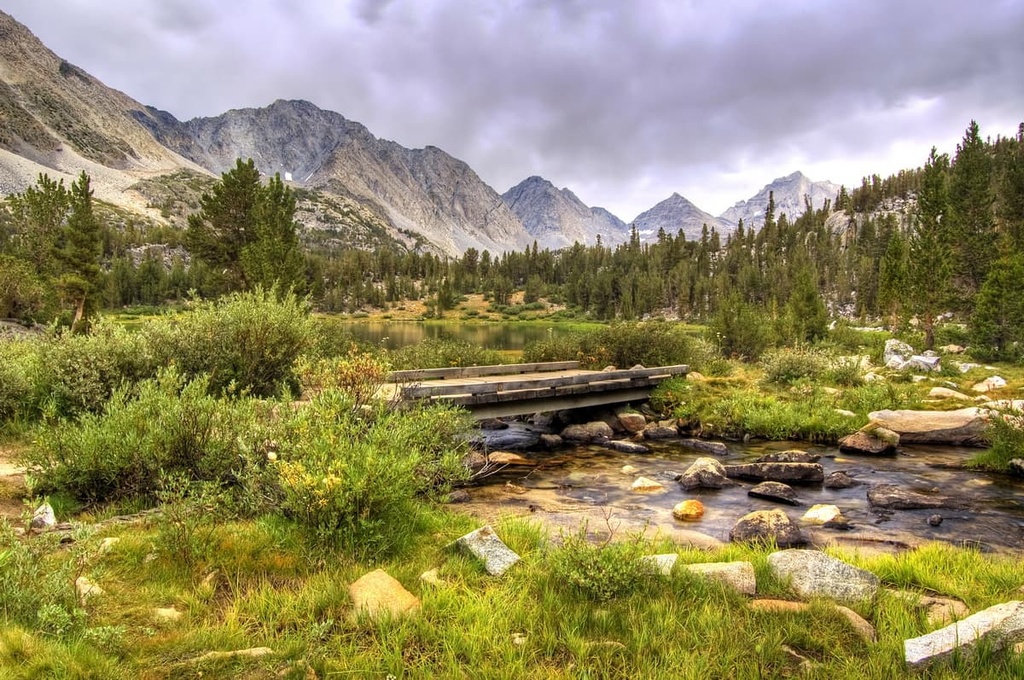
A majority of the most popular hikes within the forest can be found in the Ruby Mountain Wilderness. The wilderness spans 92,652 acres (37,495 ha) of land across the rugged and stunning landscape. Hikers in the wilderness can experience steep forested hillsides, alpine meadows, alpine lakes, glacial cirques and jagged peaks.
Common hikes in the wilderness include:
While there are numerous other wilderness areas within the Humboldt National Forest, many have few to no designated trails. Below are a handful of the other popular trails that you can find throughout the forest:
Looking for a place to stay near the Humboldt National Forest? Here are some of the best cities and villages to check out in the region.
Reno is the closest major city to much of the Humboldt National Forest, and it is situated in western Nevada. Referred to as “The Biggest Little City in the World,” Reno is known for its multitude of casinos and proximity to world-class outdoor recreation destinations. Reno is also the second most populous city in the state with a metro population of around 425,000 people.
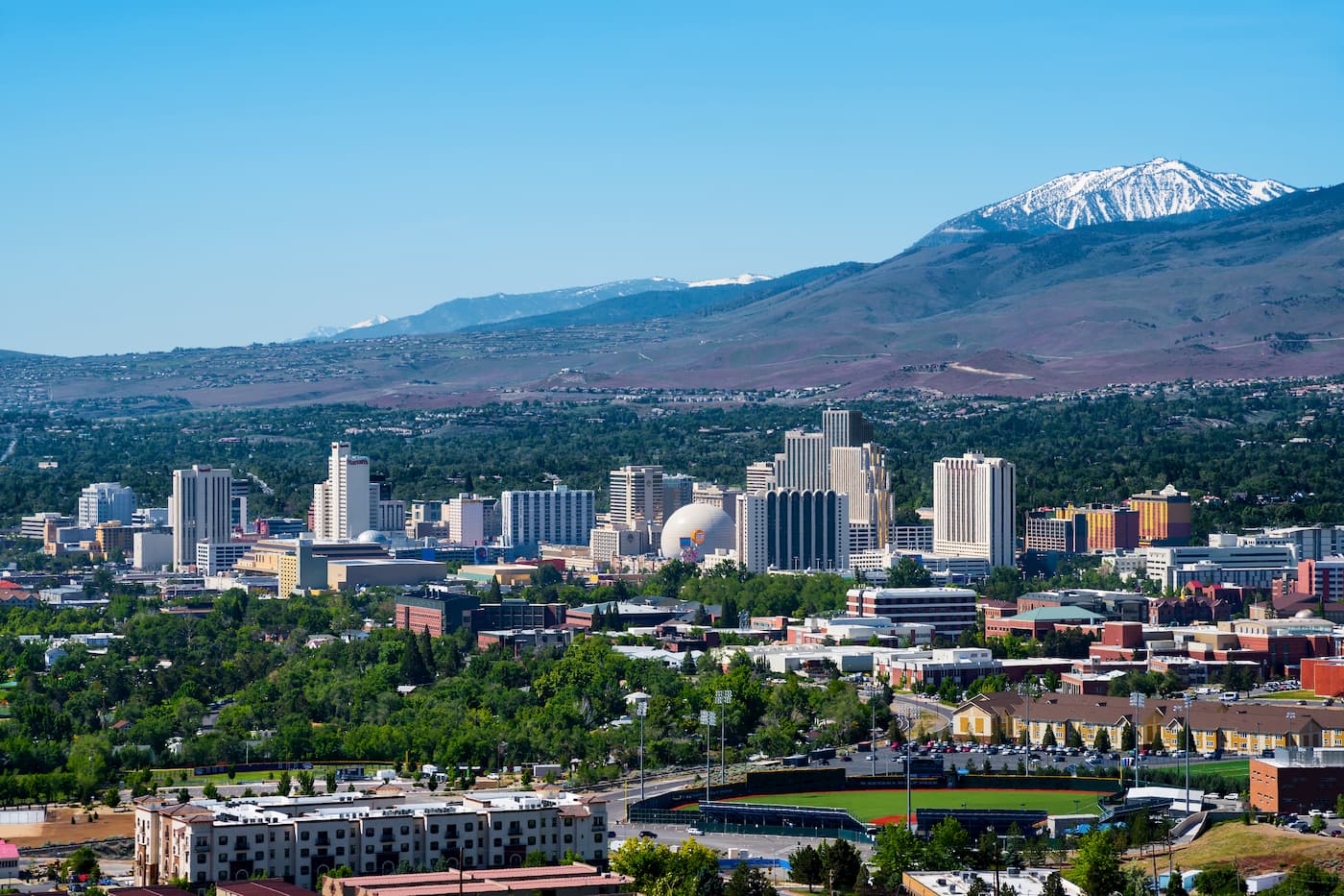
Besides its numerous casinos, Reno is also home to the Nevada Museum of Art. During the summer months, the surrounding landscape provides hundreds of miles of trails for hiking, trail running, and mountain biking. Rock climbing is also popular during the summer months. During the winter, nearby ski resorts provide locals and tourists alike with opportunities for skiing, snowboarding, snowshoeing, and snowmobiling.
The city of Ely, Nevada lies along the state’s eastern edge on US Route 50, which is often referred to as the “Loneliest Road in America.” Ely is a remote mountain town located just outside the High Schells Wilderness Area.
With a population of around 4,000 people, Ely provides the ideal starting point for adventures into the forest and Great Basin National Park, the latter of which features the Lehman Cave system.
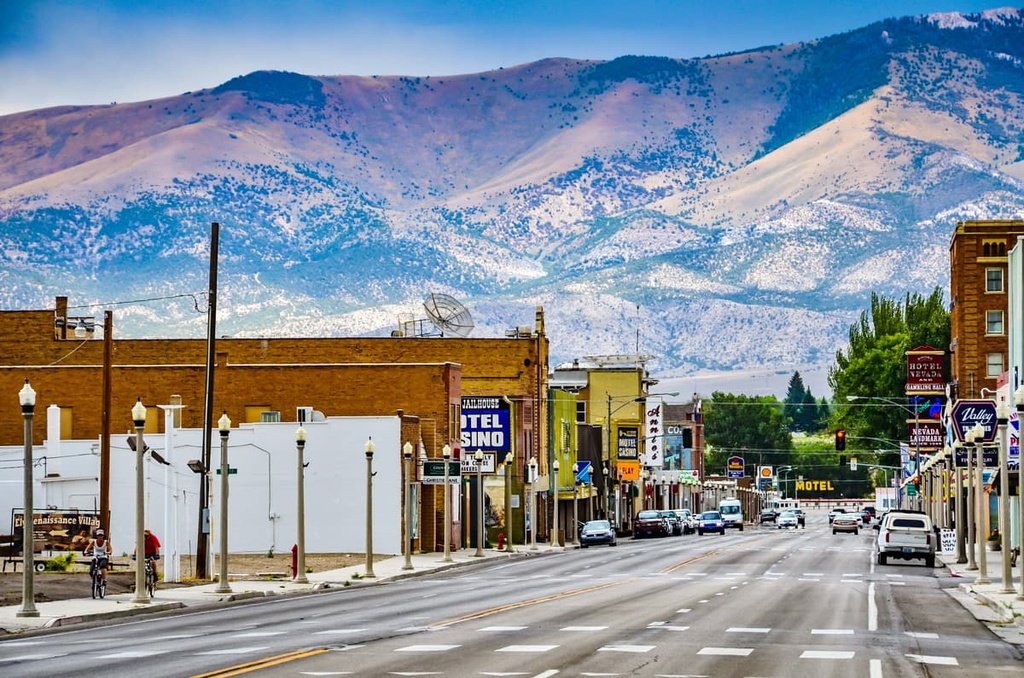
Additionally, those visiting the region will often find that the trails are less busy than they are elsewhere due to the city’s remote location. For a more urban adventure, downtown Ely features an 11-block art walk along with local restaurants and shops.
Elko is a small city that lies to the east of Reno in north-central Nevada. Home to around 21,000 residents, the city serves as an economic hub for the Ruby Region. Situated along the Humboldt River, Elko lies next to the Ruby Mountains and Lamoille Canyon.
The Ruby Mountain Wilderness and other surrounding mountains allow for year-round outdoor recreation including hiking, skiing, biking, rock climbing, and hunting. The city is home to Great Basin College, and each year, Elko hosts the National Cowboy Poetry Gathering and the National Basque Festival.
Numerous hot springs surround the city, too, and the most popular is the Elk Hot Hole. Additionally, the Western Folklife Center is a non-profit cultural center in the city that’s well worth checking out if you get a chance to visit.


nevada-11ers
nevada-peaks-club
las-vegas-mountaineers-classics
western-state-climbers
western-state-climbers-star
great-basin
ultra
nevada-11ers
nevada-peaks-club
las-vegas-mountaineers-classics
western-state-climbers
western-state-climbers-star
great-basin
nevada-ultras
nevada-11ers
nevada-peaks-club
las-vegas-mountaineers-classics
western-state-climbers
western-state-climbers-star
great-basin
nevada-11ers
nevada-peaks-club
las-vegas-mountaineers-classics
nevada-peaks-club-emblem
western-state-climbers
western-state-climbers-star
sierra-club-desert
great-basin
nevada-11ers
nevada-peaks-club
western-state-climbers
western-state-climbers-star
great-basin
nevada-11ers
nevada-peaks-club
las-vegas-mountaineers-classics
western-state-climbers
western-state-climbers-star
great-basin
ultra
nevada-11ers
nevada-peaks-club
las-vegas-mountaineers-classics
western-state-climbers
western-state-climbers-star
great-basin
nevada-ultras
nevada-11ers
nevada-peaks-club
las-vegas-mountaineers-classics
western-state-climbers
western-state-climbers-star
great-basin
nevada-11ers
nevada-peaks-club
western-state-climbers
western-state-climbers-star
great-basin
nevada-11ers
nevada-peaks-club
las-vegas-mountaineers-classics
nevada-peaks-club-emblem
western-state-climbers
western-state-climbers-star
sierra-club-desert
great-basin
nevada-11ers
nevada-peaks-club
las-vegas-mountaineers-classics
western-state-climbers
western-state-climbers-star
great-basin
nevada-peaks-club
nevada-peaks-club-emblem
western-state-climbers
western-state-climbers-star
great-basin
nevada-11ers
nevada-peaks-club
las-vegas-mountaineers-classics
western-state-climbers
western-state-climbers-star
great-basin
nevada-peaks-club
western-state-climbers
western-state-climbers-emblem
great-basin
The highest peak in Humboldt National Forest is Mount Moriah, at 3,677 m.
Notable peaks in Humboldt National Forest include Mount Moriah, North Schell Peak, South Schell Peak, Taft Peak and Currant Mountain.


