Scan the QR code and open PeakVisor on your phone
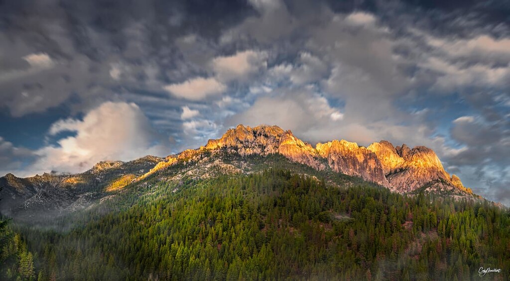
Established in 1984, the Castle Crags Wilderness protects roughly 10,500-acres (4,249 ha) of lofty granite spires, steep-sided canyons, and alpine lakes within the Shasta-Trinity National Forest in the northern part of the US state of California. There are 4 named mountains in the wilderness, the highest and most prominent of which is Castle Crags, an impressive, granitic rock formation that towers over 6,000 feet (1,828 m) above the surrounding wilderness.
The Castle Crags Wilderness is a federally protected area that contains several imposing rock formations within the Trinity Mountains, a subrange of the Klamath Mountains that stretches from the North Yolla Bolly Mountains in northern California to the Siskiyou Mountains in Oregon.
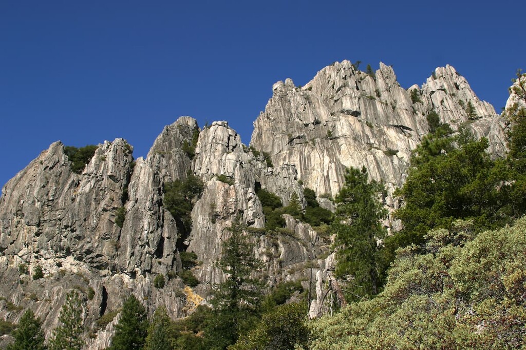
The most prominent feature in the wilderness is Castle Crags, a compact granitic set of spires tucked in the Trinity Divide. Located along the southeast boundary of the park, Castle Crags rises abruptly from the surrounding wilderness. The Crags’ striking stature and proximity to Interstate 5 make it one of the most recognizable natural features in the region.
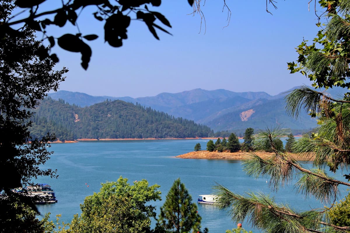
Elevations in the Castle Crags Wilderness range from 2,500 feet (762 m) to 7,300 feet (2,225 m). The park is bound by the Sacramento River to the east and the South Fork Sacramento River to the north. The southeast border of the wilderness is shared with Castle Crags State Park.
The Castle Crags Wilderness is roughly divided into two sections. The eastern section of the wilderness contains the heavily glaciated granite peaks of the infamous Castle Crags. Two prominent Castle Crag summits, Castle Dome and Mount Hubris, lie in this part of the wilderness, along with several unofficially named pinnacles, including ‘Battle Mountain,’ and ‘North Pinnacle.’
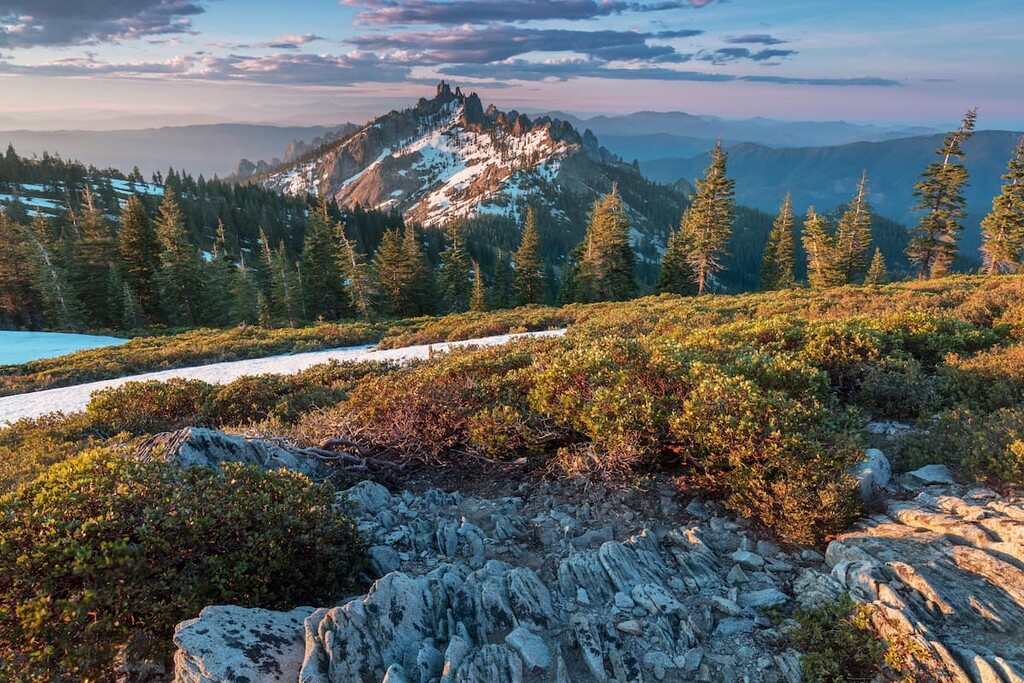
Interestingly, the western half of the Castle Crag Wilderness remains relatively inconspicuous. Visible from nearby Mount Shasta, the western portion of the wilderness contains a collection of unnamed peaks that surround the Gray Lakes basin.
Though many of these peaks reach higher elevations than the park’s more notorious eastern spires, they’re often flouted and overshadowed by the presence of Mount Shasta, Mount Eddy, and Castle Crags.
Reaching roughly 7,200 feet (2,195 m) in elevation, the informally named ‘Harry Watkins’ peak holds the unofficial title as the high point of the Castle Crags Wilderness. Nearby, another unofficially named mountain, ‘Gray Rock Dome,’ reaches just under 7,100 feet (2,164 m).
Though infrequently climbed, the nameless summits in the western part of the Castle Crags Wilderness are said to offer truly spectacular views of Mount Shasta, Castle Crags, Mount Eddy, Black Butte, and the Grey Rock Lakes Basin.
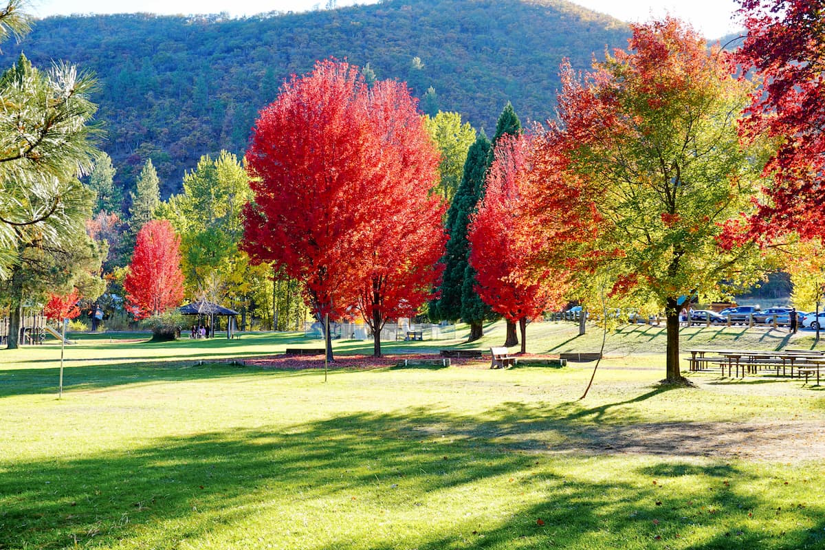
Although the Castle Crags Wilderness is fairly isolated, it is located within driving distance of some of northern California’s premier outdoor recreation destinations. This includes the Trinity Alps Wilderness, Russian Wilderness, and Marble Mountain Wilderness to the west, the Mount Shasta Wilderness to the north, and the Whiskeytown-Shasta-Trinity National Recreation Area to the south.
Though many of the mountain ranges and rock formations surrounding the Castle Crags Wilderness consist largely of volcanic and sedimentary rock, the Castle Crags themselves have a distinct and unique geological history.
Located in the Klamath Mountains geomorphic province, rocks surrounding the Castle Crags consist mostly of Ordovician period oceanic crust. In fact, the granitic columns of Castle Crags are the remnants of a pluton, or intrusive igneous rock, that formed when magma cooled and solidified underground.
For millions of years, dense slabs of oceanic rock sank beneath the western edge of North America. The spectacular, granitic Castle Crags were formed when, roughly 170 million years ago, a batch of this molten rock rose, collected beneath the Earth’s surface, and solidified.
Extensive glaciation during the Pleistocene, as well as the uplift of the Klamath Mountains, shaped the weathered crags and spires admired by visitors today. Because ultramafic rock is far less resistant to weathering than granitic rock, the Castle Crags were left protruding above the surrounding landscape.

Though the Castle Crags wilderness is best-known for its lofty granite spires and relative solitude, it also serves as an important habitat to a variety of flora and fauna. Due to its location within the Klamath Mountains Ecoregion, and more specifically the Trinity Divide, Castle Crags is renowned for its rich biodiversity.
In fact, the Klamath Mountains Ecoregion boasts the second greatest number of conifer species of any place in the world, and, just two hours west of the Castle Crags Wilderness, the Russian Wilderness sustains the largest number of conifer species in North America.
Though Castle Crags contains many acres of brush fields and rocky outcrops, it also protects a variety of mixed conifer trees, including western yew, Port Orford cedar, sugar pine, ponderosa pine, Douglas fir, white fir, and lodgepole pine.
Live oak, in particular, flourishes at lower elevations, while stands of red fir, Jeffrey pine, and weeping spruce can be found near the Crags summit. Though not quite as common, broadleaf trees in the area include bigleaf maple, vine maple, black oak, and Pacific dogwood.
Incredibly, over 300 varieties of herbaceous wildflowers thrive in the Castle Crag Wilderness, including Indian rhubarb, leopard lily, cobra plants, yellow monkey flower, Cycladenia, yarrow, aster and eriogonum.
The region’s temperate coniferous forest also protects two endemic wildflower species, the Castle Crags harebell and Castle Crags ivesia, the latter of which grows only in the rocky granite spires of the Castle Crags.

In terms of wildlife, the Castle Crags Wilderness home to a number of mammals, including black tail deer, mountain lion, black bear, gray squirrel, coyote, and bobcat, as well as an array of bird species, including hawks, golden eagles, peregrine falcons, scrub jays, Stellar jays, ravens, warblers, sparrows, nuthatches, and wrens. Reptiles known to frequent the area include the western fence lizard and western rattlesnake.
For thousands of years the forested acres surrounding Castle Crags were occupied by Indigenous peoples, including the Wintu, Achumawi, and Modoc. Indigenous peoples thrived on the region’s natural resources, utilizing the area’s streams, forests, natural springs, and waterways to fish, trade, and harvest food.
The Wintu, in particular, lived near the base of Castle Crags, referring to the granitic spires as ‘the Abode of the Devil.’ Though they rarely, if ever, ventured to the pinnacle of the Crags, they viewed the formation with a sense of awe and superstition.

The Okanuchu Shasta, whose territory spanned roughly 700 sq. mi (1813 sq. km) from the headwaters of the Sacramento River to the McCloud River and from Mount Shasta to Pollard Flat, also admired the Crags, believing that spirits took human forms to live amidst the spires.
Unfortunately, life changed dramatically in the region with the arrival of early European and European-American settlers and fur traders in the early 1820s. By 1833, the Okwanuchu Shasta had been decimated by malaria brought by early colonizers and conflict quickly escalated between miners and the Wintu when gold was discovered in the region in 1848.
In the mid 1850s, strained relations between miners and Tribal Nations reached a breaking point when hundreds of gold miners flooded the region, destroying fishing waters in the Lower Soda Springs area and decimating other life-sustaining resources.
Growing conflict between Indigenous peoples and white settlers culminated in the Battle of Castle Crags below Battle Rock in 1855, when a group of white settlers clashed with a band of Upper Trinity Wintu and Modoc people between Castle Lake and Battle Rock.
By the 1920s, the introduction of the Southern Pacific Railroad to the Upper Sacramento Valley had triggered large scale logging and gold mining to the region. Roughly a decade later, local residents interested in protecting the area successfully acquired 925 acres (374 ha) of land to establish Castle Crags State Park and the Civilian Conservation Corps started working on building trails and roads to make the park accessible to the public.
In 1984, the Castle Crags Wilderness was established when President Reagan signed the California Wilderness Act. It is now managed by the US Department of Agriculture as part of the Shasta-Trinity National Forest.
The Castle Crags Wilderness contains 27.8 mi (44.7 km) of developed and maintained trails that can be accessed via 9 designated trailheads. If you’re looking to explore the wilderness by foot, these are some of the most popular trails in and around the park:
Arguably the most popular trail in the wilderness, the 5.4-mile (8.7 km) Castle Dome trail climbs roughly 1,900 feet (579 m) to the base of Castle Dome.
Rising abruptly from the Vista Point, the Castle Dome trail meanders through Castle Crags State Park before making its way to a scenic saddle nestled between Castle Dome and the Crags’ eastern face in the Castle Crags Wilderness.

At just 3 miles (4.8 km) long, the Heart Lake Trail is cherished both for its incredible vistas of the Trinity Divide and its relative ease.
The trail begins at the Castle Lake trailhead and climbs 1,175 feet (358 m) to remarkable views of Mount Shasta, Black Butte, Mount McLoughlin, and Castle Lake. Experienced hikers can continue on to summit ‘Castle Peak,’ which lies between the illustrious Castle Crags and the crest of the Trinity Divide.

Like the Heart Lake trail, the 2.5-mile (4 km) Gray Rock Lake trail is a short and relatively steep trail that features expansive views of an isolated lake basin high above the South Fork of the Sacramento River.
Nestled beneath ‘Gray Rock Dome’ and ‘Harry Watkins,’ three beautiful lakes—Gray Rock Lake, Upper Gray Rock Lake, and Timber Lake—occupy the only complete lake basin in the Castle Crags Wilderness. The trail to Gray Rock Lake not only offers access to these scenic lakes but can also be used to reach climbing routes on 'Harry Watkins’ and ‘Gray Rock Dome.’
Boasting incredible views of the north side of the Castle Crags and Castle Crags Wilderness, the 6-mile (9.7 km) Mount Bradley Ridge trail begins at Castle Lake, weaving in and out of pine trees and through open meadows, before climbing to a lookout perched 3,000 feet (914 m) above nearby Dunsmuir.
On the way to the summit of Mount Bradley, hikers can also take a dip in Little Castle Lake, a small trailside lake that is popular among hikers, campers, and photographers.

Nineteen miles of the Pacific Crest Trail, which spans 2,650 miles (4,265 kilometers) from the US border with Mexico to the US border with Canada, passes through the Castle Crags Wilderness.
Generally, hikers will attempt the Castle Crags portion of the PCT as a one-way trek beginning at the Dog Trail Trailhead and ending at Soda Creek. However, hikers can also link up with the PCT from a number of trailheads in Castle Crags State Park.
Though maintained trails in the Castle Crags Wilderness do not lead directly through the spires of the Crags themselves, these diorites and granodioritic cliffs are regularly accessed by climbers and other recreationists.
Most of the climbing is centered around the Cosmic Wall, which ascends ‘Mount Hubris.’ However, popular routes also exist on Castle Dome and ‘Six Toe Rock,’ a smaller crag located along the Castle Dome Trail.

Climbers are urged to consider safety factors when attempting to summit these ancient granitic spires. In addition to being incredibly isolated, the Crags are known to exhibit exfoliation, which impacts the stability of the granitic rock.
Looking for a place to stay during your visit to the Castle Crags Wilderness? Here are some of the best cities and towns to check out:
Located on the flanks of Mount Shasta, Mount Shasta City lies just 40 miles (64 km) north of the Castle Crags Wilderness. A lively alpine town, Mount Shasta City is best-known for its winter recreation and luxury ski resorts.
However, the city is truly an all-seasons destination. Visitors to Shasta City can explore the many miles of hiking trails in nearby Shasta-Trinity National Forest, Castle Crags State Park, and Mount Eddy, fish at Lake Siskiyou and Castle Lake, or kick back and enjoy the many amenities and facilities available in town.
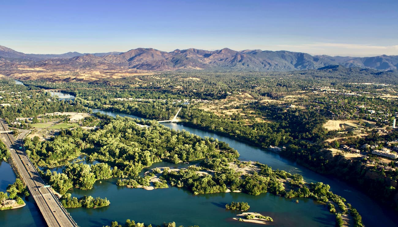
Redding is located less than 60 miles (95 km) south of the Castle Crags Wilderness along the Sacramento River and is the largest city in the Shasta Cascade region. Home to 200+ miles (320+ km) of hiking and biking trails and 300+ days of sunshine a year, it's easy to see why Redding is an outdoor paradise.
Redding is central to several parks and historic places, including Lassen Volcanic National Park, Castle Crags State Park, the Shasta State Historic Park, and Shasta-Trinity National Forest.
Home to the alleged ‘best water on Earth,” Dunsmuir lies on the upper Sacramento River in the Trinity Mountains. The city’s location on a blue-ribbon trout stream makes it a particularly popular destination for anglers.
But, Dunsmuir is also nestled within some northern California’s most iconic summits, including Mount Shasta, Castle Crags, and the Trinity Alps. Although Dunsmuir has managed to retain its old town charm, it still offers plenty of lodging and dining options for visitors to enjoy.
Located near the Shasta River in Siskiyou County, Yreka is a relatively small town founded during the gold rush era. As a result, the community has a rich and diverse history.
While history buffs will surely appreciate the well-preserved historic homes and museums in town, outdoor enthusiasts will also appreciate Yreka’s close proximity to two of northern California’s most cherished wilderness areas—Shasta-Trinity National Forest and Klamath National Forest.