
Scan the QR code and open PeakVisor on your phone
Akamina-Kishinena Provincial Park is a mountainous protected area that’s located in the southeastern corner of British Columbia, Canada, near Waterton Lakes National Park in Alberta and Glacier National Park in the US state of Montana. This rugged, high elevation park encompasses steep forested slopes, raging waterfalls, stunning lakes, and 7 named mountains, the highest and most prominent of which is King Edward Peak (2,791 m/9,157 ft).
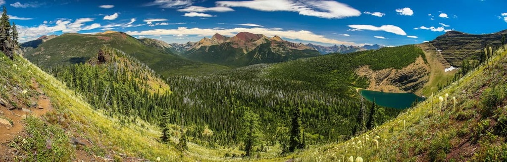
The southeastern corner of British Columbia, Canada is home to the jagged peaks of Akamina-Kishinena Provincial Park. This rugged, high elevation wilderness park is home to lakes, waterfalls, hiking trails, and 7 named peaks.
King Edward Peak is the highest and most prominent of the mountains in the park. The mountain is 2,791 m (9,157 ft) tall and it has 587 m (1,926 ft) of prominence. King Edward Peak overlooks the popular trails that lead to Forum Peak and Akamina Ridge.
Akamina-Kishinena Provincial Park is part of the so-called Crown of the Continent, which is the narrowest point of the Rocky Mountains. It is situated near both Waterton Lakes National Park in Alberta and Glacier National Park in Montana. Other parks that are located near Akamina-Kishinena include:
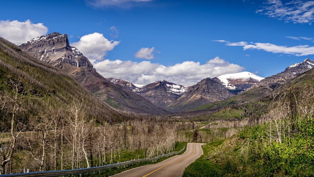
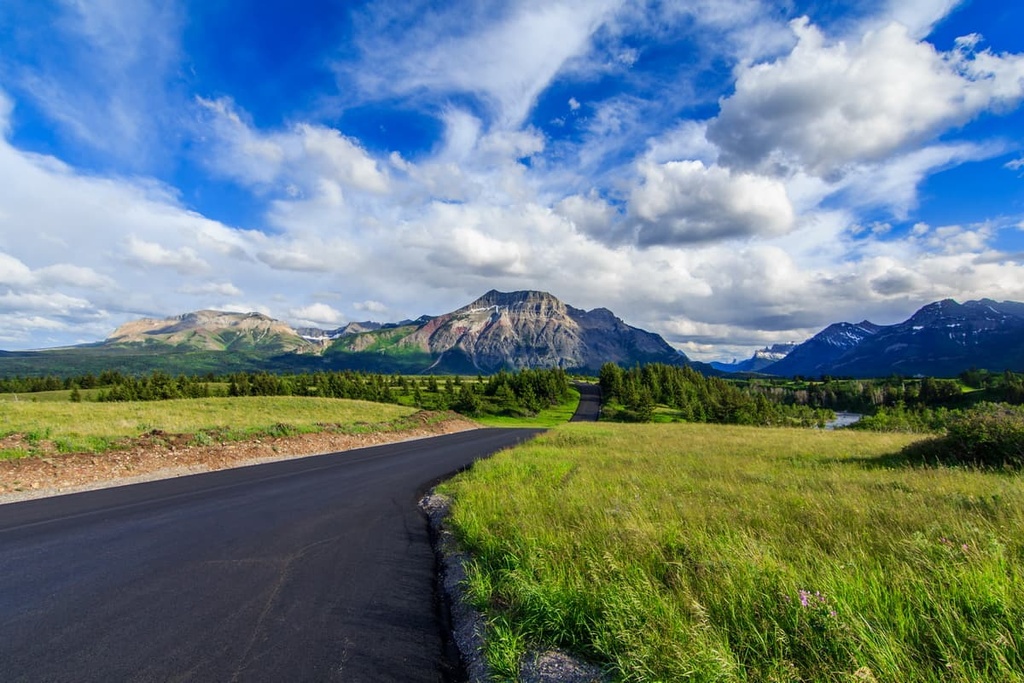
While there are some logging roads that travel to areas near the western borders of the park, the most common access to the Akamina-Kishinena is from the east. Most visitors to the park travel over Akamina Pass from Waterton Lakes National Park to explore the incredible wilderness trails of Akamina-Kishinena Provincial Park.
The peaks within Akamina-Kishinena Provincial Park are part of the greater Rocky Mountains. As the park is located along the border of British Columbia and Montana, its peaks are part of a transitional zone between the Central Montana Rocky Mountains to the south and the Canadian Rockies to the north.
In particular, some of the peaks within Akamina-Kishinena Provincial Park are considered to be part of the Clark Range, which is a subrange of the Canadian Rockies that’s located in the far northern section of Glacier National Park and the southern section of Akamina-Kishinena Provincial Park. The Clark Range is located to the north of both the Livingstone Range and the Lewis Range.
In general, the peaks in the provincial park, which are often called the “Crown of the Continent,” formed alongside the rest of the Rocky Mountains. These peaks started to form about 70 million years ago when the North American plate collided with tectonic plates from the southwest. This caused the layers of rock that were located along the ancient continental margin to fold, twist, and uplift to form the Rocky Mountains.

During a mountain-building event that’s referred to as the Laramide orogeny, the Rocky Mountains were uplifted above sea level over a period of about 45 million years. The modern-day Rocky Mountains extend from the northern reaches of British Columbia and Alberta down through the US states of Idaho, Montana, Wyoming, Utah, and Colorado until they reach their southern terminus in New Mexico.
Akamina-Kishinena Provincial Park is home to some of the oldest mineral formations in the Rocky Mountains. The 1.5-billion-year-old limestone formations in the park were created from the accumulation of sediment and the shells of dead sea creatures on the shallow ocean floor that once existed along the ancient continental margin.
While some of the rocks of Akamina-Kishinena Provincial Park formed over a billion years ago, most of the rocks in the area formed during the Paleozoic and Cretaceous. The Paleozoic rocks that are found in the park are primarily limestones whereas the layers of sandstone, mudstone, and shale that exist in the region typically formed during the Cretaceous.
During the last few million years, the mountains in the park experienced multiple periods of glaciation. The most recent period of glaciation in the region ended about 12,000 years ago when the bulk of the ice sheets melted. As the glaciers formed and subsequently melted, they carved out the region’s mountains and valleys, creating the landscape that we see in the park to this day.
Furthermore, the high concentration of limestone in the region has allowed for the formation of karst topography throughout Akamina-Kishinena Provincial Park. At the same time, the park’s alpine glaciers have created classic examples of cirques and basin lakes on the region’s rugged mountain slopes.
The rugged peaks and high elevation valleys of Akamina-Kishinena Provincial Park are part of a greater ecosystem that also includes Waterton Lakes National Park and Glacier National Park. Together, the parks protect important habitats for the grizzly bears and wolves that live on both sides of the international border.
The intermingling of warm Pacific air with Arctic air along the axis of the park has allowed a unique ecosystem to flourish in the region. Here, you can find plant species, such as the yellow monkeyflower and the pygmy poppy, that do not grow anywhere else in British Columbia.
As it includes important areas of the Engelmann Spruce-Subalpine Fir and Montane Spruce ecosystems, Akamina-Kishinena Provincial Park provides critical habitat to many rare and endangered species. In addition to populations of grizzly bears and wolves, the park is also home to black bears, moose, cougars, elk, and white-tailed deer.
Some of the other animal species that inhabit that park include Rocky Mountain red-tailed chipmunks, Rocky Mountain least chipmunks, Rocky Mountain red-backed voles, and tailed frogs.
Toward the end of the Pleistocene, around 12,000 years ago, the southern Canadian Rockies became one of the first areas in the region to be free of ice. Thanks to this subsequent lack of a permanent ice cover, plants started growing in the region.
The growth of new plants eventually drew herds of herbivores to the range, which were soon followed by carnivorous animals. Humans also tended to follow herd migrations, so many early human residents of the region arrived around this time.
The remote corner of British Columbia that includes Akamina-Kishinena Provincial Park is part of the traditional territory of the Ktunaxa (Kootenay) First Nations. This area is of cultural and spiritual value to the First Nations that traditionally lived in the region. Indeed, cairns still trace the paths of the Ktunaxa who traditionally traveled across South Kootenay Pass to hunt buffalo and trade on the plains.
Europeans eventually started arriving in the region, first as explorers and fur traders and then finally as industrialists. The lack of major modern-day settlements in the area around the park is a testament to the failed industrialization of the region.
That said, this failure of industrialization in the region wasn’t due to a lack of effort. As early as 1905, oil rigs were hauled into the area by industrialists who hoped to strike it rich. However, like the mining claims that people also made in the region, none of these wells or mines proved viable in the area around what is now Akamina-Kishinena Provincial Park.
Instead, the area was used by hunters and trappers who were attracted to the large amounts of big game in the Rocky Mountains. There was also a small sawmill on Akamina Creek during this time; however, this spectacular wilderness was recommended for conservation as early as 1917.
While it took until the end of the twentieth century to formally protect the region, in 1995, Akamina-Kishinena Provincial Park was established in order to conserve the unique geology and ecology of the Crown of the Continent.
Akamina-Kishinena Provincial Park is only open to non-motorized methods of travel, such as hiking and horseback riding. Nevertheless, the stunning lakes, waterfalls, geological formations, and beautiful wilderness and wildlife in the region attract many visitors to the park.
The following are some of the best trails and attractions in Akamina-Kishinena Provincial Park for you to check out during your next trip to the region.
The Akamina Pass Lookout Trail is a relatively short and casual hike that starts from a trailhead on the Akamina Parkway at the western end of Waterton Lakes National Park.
This 5.5 km (3.3 mi) round-trip hike has just 230 m (750 ft) of elevation gain. It follows a well-maintained trail up to Forum Falls and the Akamina Creek Campground. The views of the falls and Akamina Pass make this easy hike well worth the effort.
The Forum Peak and Akamina Ridge Loop starts from the same trailhead as the Akamina Pass Lookout Trail. However, for this hike, you’ll continue down the path along the Forum Lake Trail, which leads to a scramble up Akamina Ridge.
After you reach the ridge, you’ll be rewarded with a stunning view of the park. The trail then meanders down the ridge and brings you to the col on Forum Peak. You’ll then finish the route by descending through Brenner Pass to the beautiful Wall Lake. From the lake, it’s a relatively easy 5 km (3 mi) hike back to the trailhead.
Note that this 21 km (12.6 mi) hike is considered difficult as there is a section of minor scrambling that you have to complete along the way.
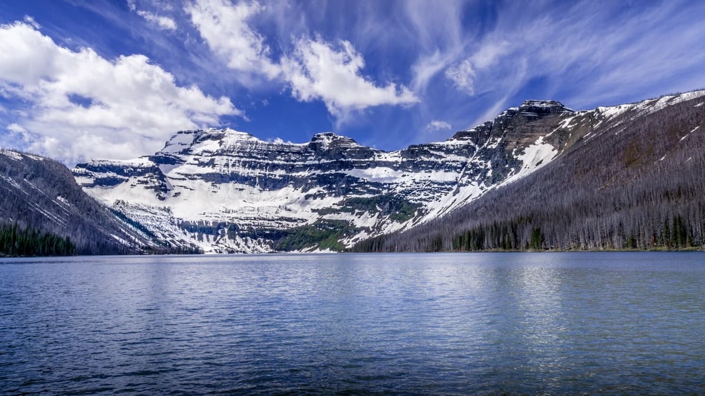
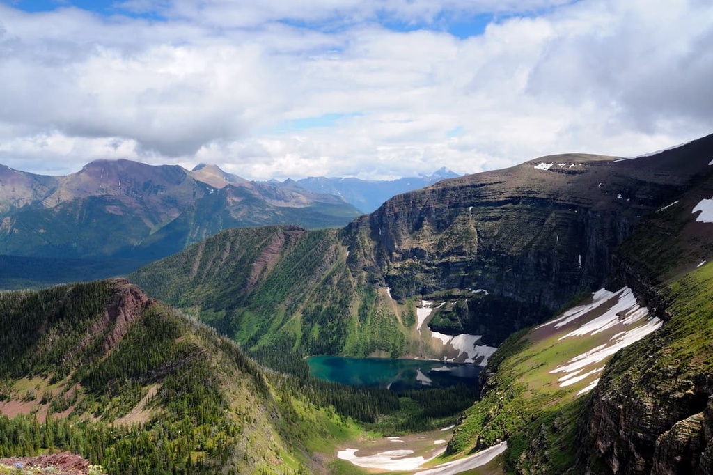
Considered by locals to be a moderately easy hiking trail, this 11.4 km (6.8 mi) out-and-back trek to Wall Lake is a fantastic option for anyone looking for a day-long adventure in the southern Canadian Rockies.
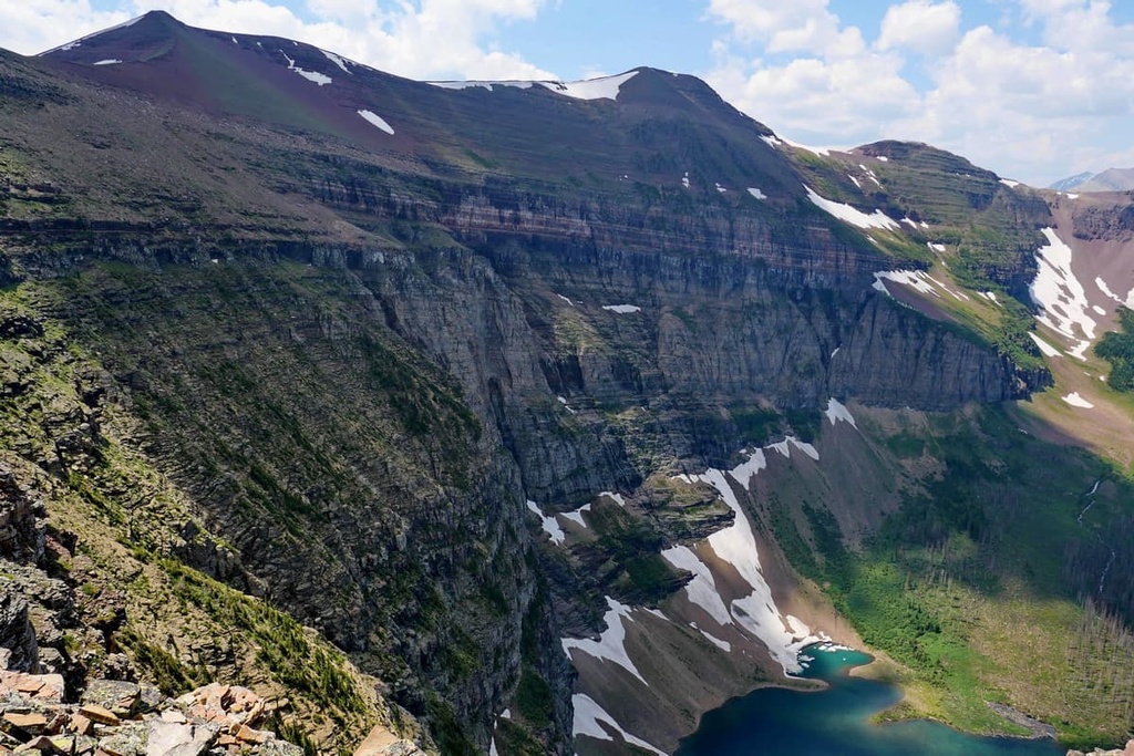
As it sits beneath a sheer limestone rock wall that’s surrounded by patches of snow that persist until late summer, Wall Lake is a truly stunning destination within Akamina-Kishinena Provincial Park. This trail is open for hiking year-round; however, many hikers find that snowshoes are helpful in the spring, fall, and winter months.
Since it is located in the far southeast corner of British Columbia, the primary way to get to Akamina-Kishinena Provincial Park is through Waterton Lakes National Park in Alberta. Even though the region is fairly remote, there are a number of communities that are located within driving distance of the provincial park.
Here are some of the best cities and towns in the region to check out during your next trip to Akamina-Kishinena Provincial Park.
Named for the wooden spars that were harvested from its nearby forests to support British Columbia’s shipbuilding industry during the late nineteenth century, Sparwood is a remote community of around 3,800 people. The town of Sparwood has grown dramatically over the years since its inception as a stop along the Canadian-Pacific Railway.
Sparwood is located to the northwest of Akamina-Kishinena Provincial Park along the Elk River. While it’s situated relatively close to the park, access to Akamina-Kishinena from Sparwood is only available via a labyrinth of forestry roads.
To this day, the community of Sparwood fully embraces its mining and logging culture, which are the primary industries in the region. Along the edge of the Crowsnest Highway, Sparwood touts its mining heritage with its display of the Terex Titan. The Terex Titan is a giant green dump truck that was once the largest truck in the world. It currently serves as a landmark for the local Visitor Information booth.
From the visitor center, you can grab a map of the local hiking and biking trails, which were mostly created by the Sparwood Trails Association. Among the many kilometers of trails for hiking and cycling in the city, there are also some that are groomed for fat biking, cross-country skiing, and snowshoeing during the winter months.
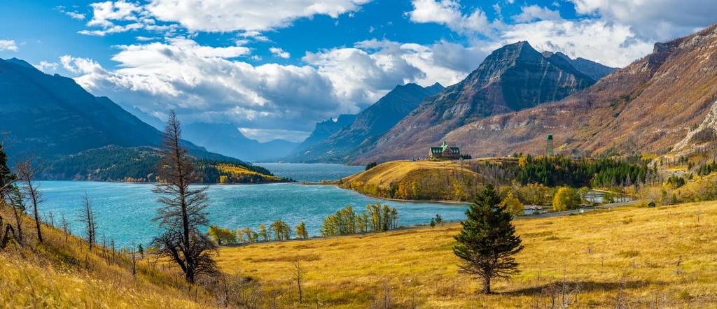
The Waterton townsite is located in Waterton Lakes National Park, which is situated adjacent to Akamina-Kishinena Provincial Park and provides access to the provincial park via Akamina Pass. While the park was formally established in 1895, the townsite didn’t really grow until the Great Northern Railway constructed the Prince of Wales Hotel in the area in 1926.
The Prince of Wales Hotel is one of the grand railway hotels, and it was built to be like the Chateau Lake Louise and the Banff Springs Hotels in Banff National Park. The hotel was built to help entice American tourists to the park during the US prohibition era.
Like the townsites of Jasper and Banff, Waterton Village is the epicenter of cultural activities and services of the national park. Whether you’re staying at the hotel, the town campground, or one of the backcountry campgrounds in the region, there are many sites and attractions to visit during any trip to Waterton.
Some of the popular hikes in the area around Waterton include the trail up Bear’s Hump, which you can pick up from the townsite. If you take a quick shuttle across the lake, you can even reach the trailhead for Crypt Lake, which is one of the most scenic destinations in the region. Plus, Crypt Lake is located along the US border, so when you gaze across the lake during your hike, you can see the peaks in Glacier National Park in the distance.


