
Every sunrise calendar has a favorite landscape: an infinite, empty plain.
That is useful at the beach. In the mountains, it is fiction. A wall to the east can keep a valley in shade for hours after the official sunrise. A western ridge can take the light long before the calendar says the day is over.
PeakVisor's Panorama 3D now reads the skyline from the exact point you are viewing and works out when the Sun and Moon actually clear it. The result is a time for this place, over the terrain that is really there.
The Calendar and the Mountain Disagree
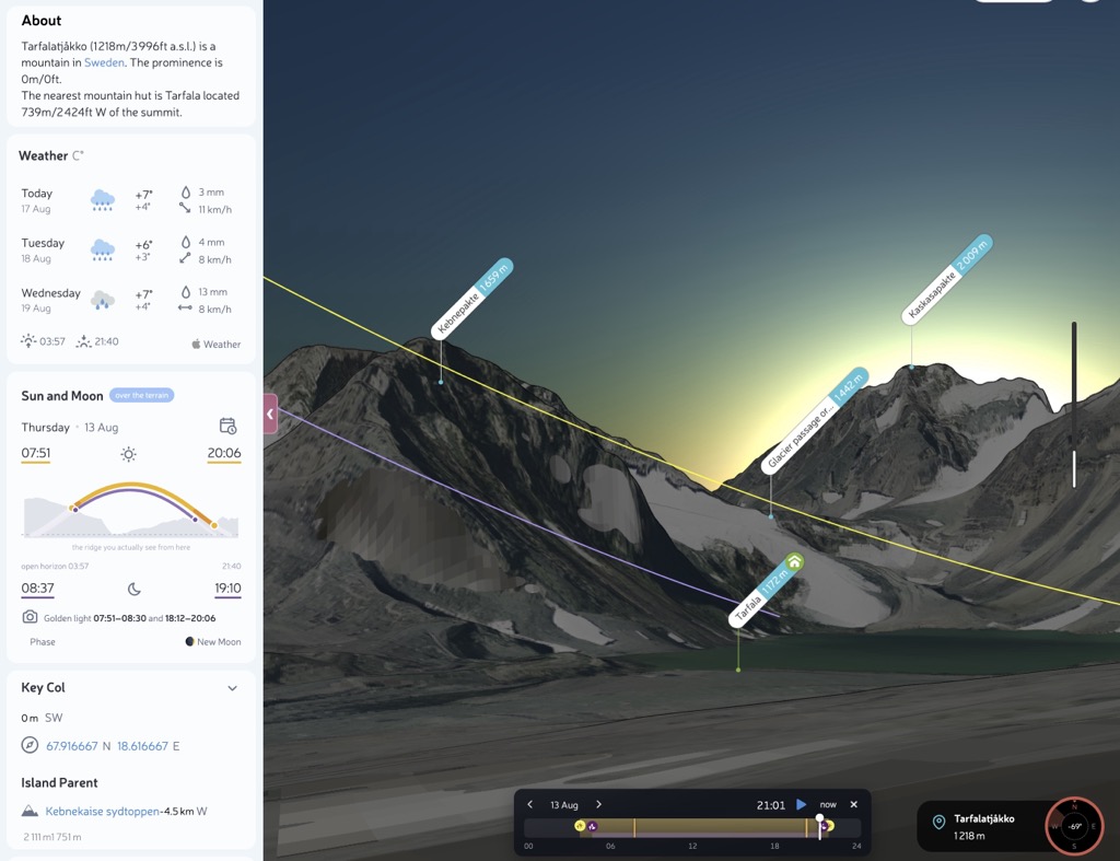
Take Tarfalatjåkko in Swedish Lapland on 13 August. An open horizon puts the Sun above the horizon before 04:00 and keeps it there until after 21:40. The mountain has a different schedule.
From the actual panorama point, direct sunlight arrives at 07:51 and leaves at 20:06. That is nearly four hours of morning light lost to the eastern wall and more than an hour and a half taken from the evening. This is not a fussy correction around the edges. It changes the day.
The local skyline is complicated enough that the Sun briefly drops behind the terrain and returns several times. PeakVisor shows the first arrival and the final departure, while the diagram reveals the dips in between. Mountains rarely cooperate with tidy calendar rows.
The Picture Is the Calculation
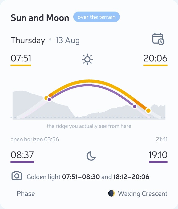
The small diagram under the times is drawn from the same terrain data as the panorama. The grey shape is the ridge as seen from that point. The yellow path follows the Sun, the purple path follows the Moon, and the orange sections mark low, visible sunlight. The pale sections show where a path continues behind the terrain.
The dots where a path meets the grey skyline are the events printed above it. They are not decorative markers added after the calculation. Move the crossing and the time moves with it.
Where a named summit sits close enough to the crossing, PeakVisor identifies it. Where the skyline is an anonymous wall, the answer says ridge. Guessing a famous peak several degrees away would make a prettier label and a worse tool.
Move Through the Day
A useful time should open a useful view. The control at the bottom of the panorama turns the calculation into something you can inspect.
- Choose a date. The Sun's December path is not its June path, especially in the far north.
- Drag the time control. The Sun, Moon, shadows, twilight, and stars move to the selected minute.
- Press play. The day slows around sunset, twilight, and an eclipse so the interesting part does not disappear in one frame.
- Step forward or back a day. This makes it quick to compare a weekend, a season, or the next full Moon.
- Share the moment. Once you settle on a time, it stays in the URL. The link opens on the same local sky.
When the Ridge Wins, the Ground Gets Dark
There is a quieter change in the panorama itself. The terrain now darkens when the Sun leaves the local skyline, not when it reaches the open horizon. At Tarfalatjåkko, the slopes lose direct light at 20:06 even though the Sun is still high enough to keep the sky bright.
That split is not a bug. It is what happens in a mountain valley: the ground goes cold and blue while daylight still fills the sky above it.
A Polar Day Can Still Have a Sunset
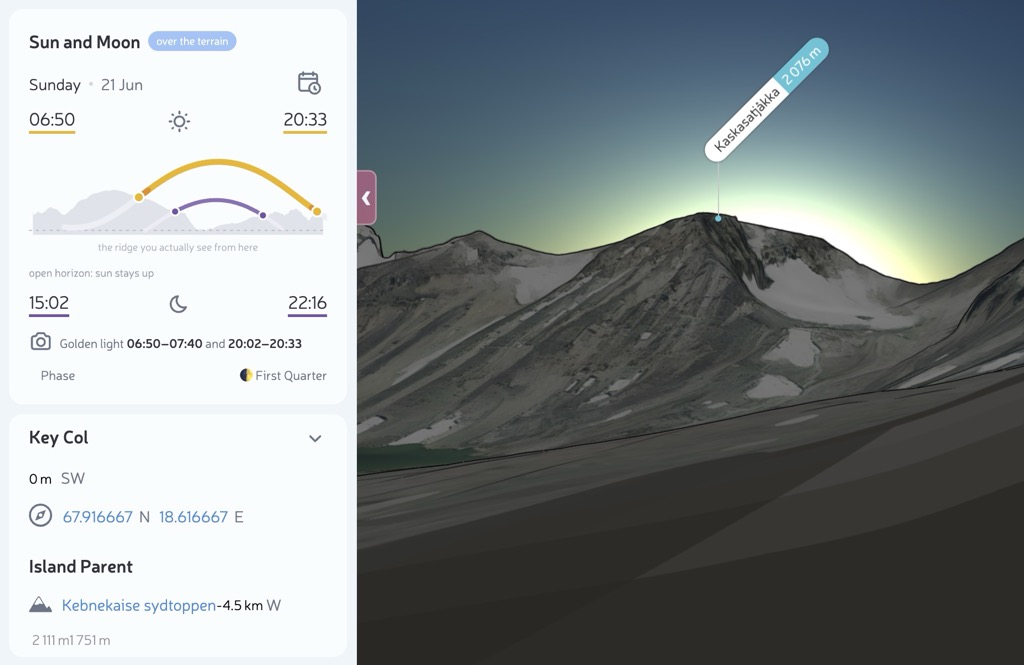
Above the Arctic Circle, the disagreement gets much more interesting. On 21 June at Tarfalatjåkko, an open horizon says the Sun stays up all day. Astronomically, it does.
The local ridges still block it. Direct sunlight reaches the panorama point at 06:50 and leaves at 20:33, behind Kaskasapakte. A day with no astronomical sunset still has a beginning and an end to the light on the ground.
Golden Light That Belongs to the Place
Photographers do not need another generic golden hour notification. They need to know whether low light reaches the camera position at all.
PeakVisor calculates the golden light windows against the same skyline, so the evening window ends when the Sun disappears behind the ridge. The Moon uses the same terrain. A full Moon rising beside a summit is the kind of photograph that rewards planning, but the plan needs the mountain in front of it, not an imaginary sea horizon.
Where It Works
Terrain times appear where PeakVisor already builds a Panorama 3D scene, including peak, viewpoint, and POI pages. Dedicated Mountain Hut pages do not yet build the same skyline, so they keep their open horizon times for now.
The answer is only as good as the terrain behind it. That is why the skyline comes from the same PeakVisor terrain model that draws the panorama. One model decides both what you see and when the light reaches it.
Open Tarfalatjåkko on 21 June at 20:33. The calendar says the Sun never sets. The ridge has other plans.