Western Towns and Rugged Wilderness. Eastern Oregon Has More to Offer Than You Might Think!
If you’re like me, when you think of the U.S. state of Oregon, you probably think of Portland, the rugged Pacific Coast, and iconic coastal towns like Astoria, Tillamook, and Newport. Inland, you may think of the Columbia River Gorge, the Cascade Range, and outdoor sports in places like Bend, Eugene, and Grants Pass.
As far as mountains are concerned, Oregon is well known for the mighty Mount Hood (11,249 ft / 3,429 m), the state’s tallest peak. Hood is Oregon’s only active volcano, and one of the most prominent peaks in the Lower 48 (7,720 ft / 2,353 m of prominence).
What I didn’t consider, until recently, is that all of these destinations are west of the state’s centerline. There’s far more to see and do in the Beaver State. A sprawling array of untrammeled wilderness regions and adventure objectives awaits in central and eastern Oregon, and these areas see a fraction of the tourists that flock to the coast and the Cascades.
A few weeks back, I took a trip through central and eastern Oregon with Dan Sizer of Go Wild Adventures, through modern-day frontier towns like John Day and Pendleton, La Grande and Baker City, around the sprawling protected areas of Umatilla National Forest and Wallowa-Whitman National Forest, wilderness regions like the Eagle Cap and Hells Canyon.
What follows is a brief overview of our route, with a few recommendations for wilderness to visit, places to stay and eat, and notable attractions.
Part 1: The Columbia River Gorge
We started our trip driving east from Portland, along the Columbia River Highway, the first paved highway in the Pacific Northwest. The Columbia River is 1,243 miles (2,000 km) long, and puts more water into the Pacific Ocean than any other river in the Americas (North or South).
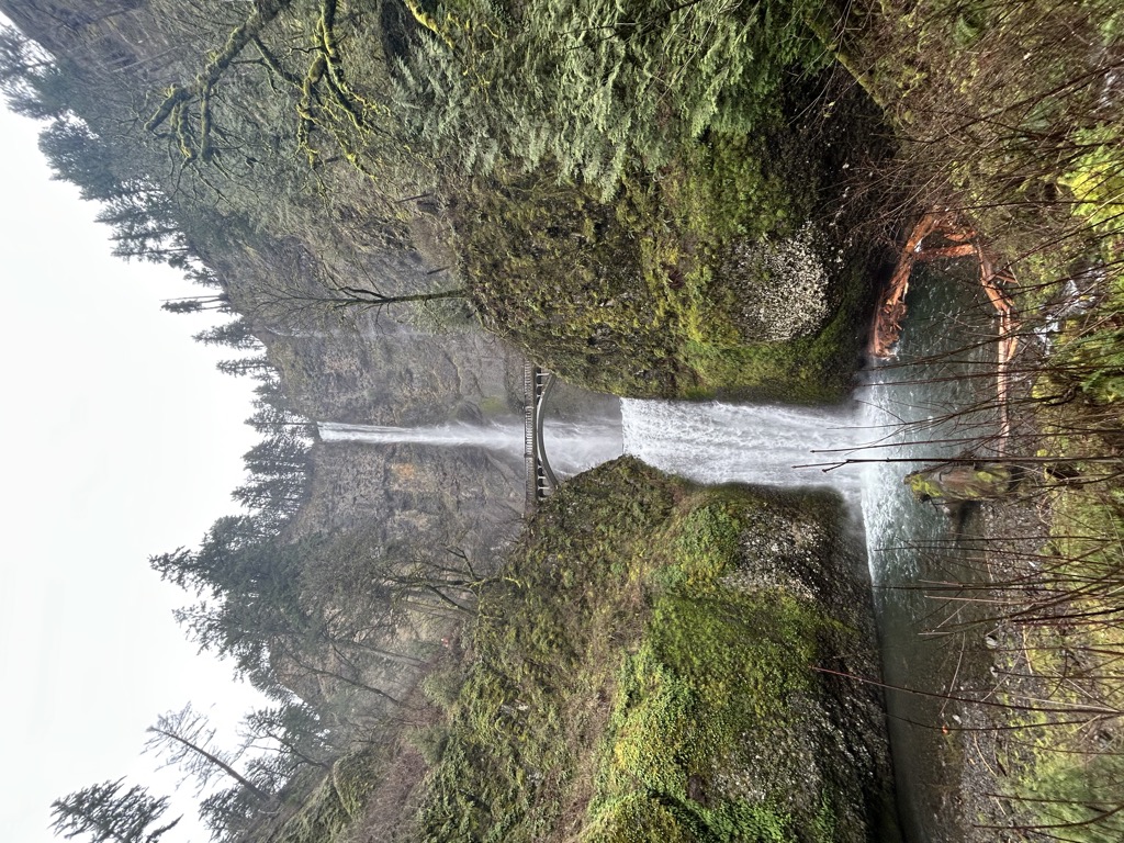
Along the way, we passed the 620-foot (189 m) Multnomah Falls, the highest waterfall in Oregon. Fed by an underground spring, Multnomah is one of the tallest year-round waterfalls in the United States, and home to a picturesque bridge dating to 1914.
Along your way down the Columbia River, it’s also worth stopping to see the Vista House at Crown Point, an observatory from 1918 with spectacular views across the valley. Both Crown Point and Multnomah Falls are just a few minutes off the highway.
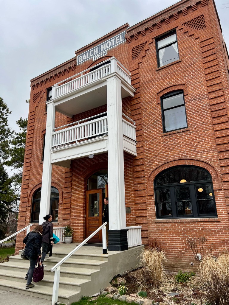
Where to Stay: Historic Balch Hotel
This 1907 hotel in the town of Dufur is a protected landmark under the National Register of Historic Places. It has on-site spa services, and with just 18 rooms, it feels more like a bed and breakfast than a traditional hotel. The hotel’s restaurant, Bistro 1907 (built that year, but opened in 1908), is also tremendous, offering a variety of local fare.
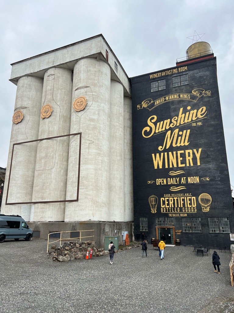
Where to Eat & Drink: Sunshine Mill
Bistro 1907 was my favorite restaurant during this leg of my trip. However, along the way to the Balch, I recommend stopping at Sunshine Mill, a winery in The Dalles, one of the key towns on the historic Oregon Trail. This family-owned winery, housed inside a historic 130-year-old flour mill, was the first building in the town to have electricity. The Thomas Edison-built motor that generated this electricity is still in the mill today!
Sunshine Mill is home to two wine companies, the Quenett Winery and Copa Di Vino (you’ve probably seen their plastic single-serve wine cups at music festivals or on Shark Tank), both owned by the same family.
Where to Hike: Badger Creek Wilderness
If you’re looking for a bit of trekking, drive down to Tygh Valley and check out the 24-mile (39 km) Badger Creek Trail up to Badger Lake in the Badger Creek Wilderness. Most parties do this as an overnight trip, camping at the lake. The hike entails 3,589 feet (1,094 m) of elevation gain.
Part 2: Northeastern Oregon
From Dufur, we drove east to Pendleton, a legendary western town. Pendleton is home to an eponymous whiskey brand, but is perhaps best known for the “Pendleton Round-Up,” an award-winning rodeo held annually in the town since 1910, and the accompanying Happy Canyon Night Show, a pageant depicting the settling of the American West, which has been held nearly as long (since 1916).
Although you won’t be able to see the rodeo unless you visit in September, you can still walk by the arena and visit the accompanying museum. While in the area, it’s also worth stopping at the Tamástslikt Cultural Institute, a museum showcasing the rich history of the local indigenous tribes, the Cayuse, Umatilla, and Walla Walla.
After Pendleton, we headed southeast to La Grande and Hot Lake, small towns in a valley, surrounded by the sprawling mountains and wilderness of Wallowa-Whitman National Forest and Umatilla National Forest.
Where to Stay: The Lodge at Hot Lake Springs
This lodge sits atop one of the largest and hottest natural springs in the entire Pacific Northwest, and—like many of the other attractions on this list—it has a rich history, with the building dating all the way back to 1864! In addition to multiple soaking pools placed around a natural hot spring, “The Lodge” has a bar, restaurant, and movie theatre showing vintage films (when I stayed there, they showed Suspiria). If you’re just stopping through, day passes are also available.
Where to Eat & Drink: Hamley's Steakhouse (Pendleton) and The Laurel (La Grande)
My favorite restaurants from this leg of the trip were Hamley's Steakhouse in Pendleton—big, juicy steaks, what’s not to like—and The Laurel, a homey cocktail bar in La Grande that offers an array of family-style charcuterie trays, as well as entrees and desserts.
Where to Hike: Mount Emily
There is a literal slew of wilderness regions surrounding La Grande, but a jaunt around the slopes of Mount Emily (6,109 ft / 1,862 m) in the Blue Mountains is a superb choice. With 1,680 feet (512 m) of prominence, Emily is the most prominent peak in Union County, and among the most prominent in Wallowa-Whitman National Forest. Just have a few hours? Try the “Recreation Area Loop,” a 7.3-mile (11.7 km) track with just under 1,000 feet of elevation gain.
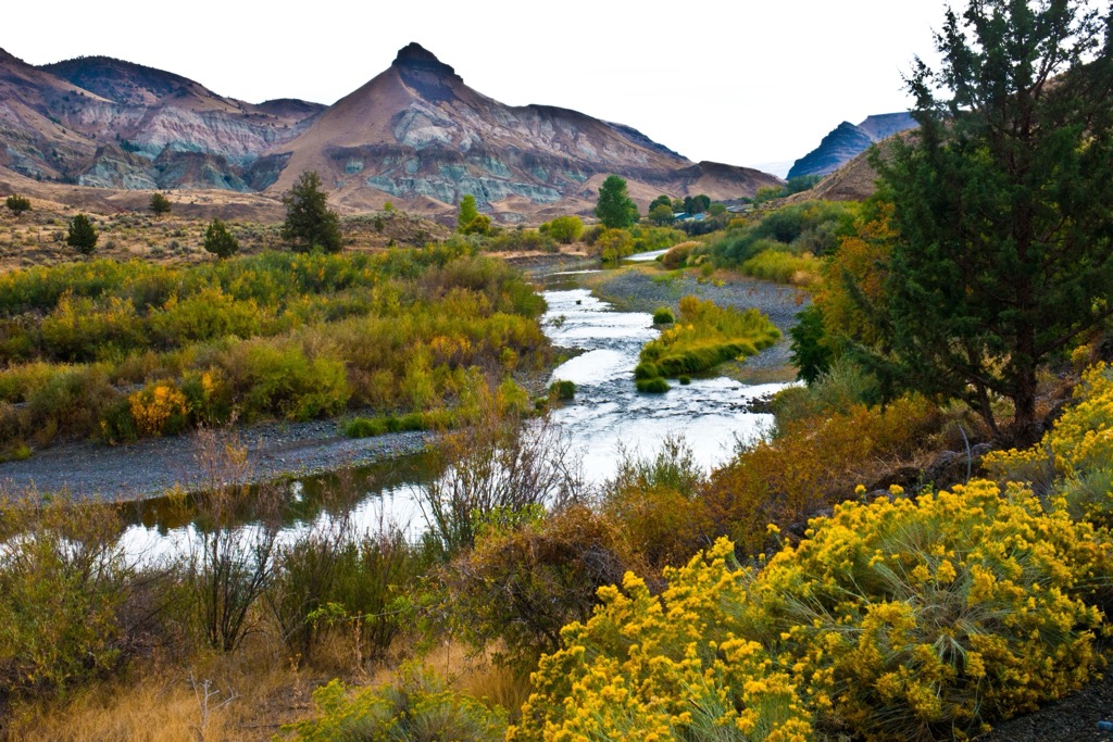
Part 3: John Day Territory
During the third leg of my trip, we drove south to Baker City, a historic western town with buildings dating to the late 1800s, and then west, through the region around the John Day River, also known as “John Day Territory.” This vast expanse is a paleontologist's paradise, most famous for the John Day Fossil Beds National Monument. Beyond the prehistoric sights, you'll find rugged canyons and charming small towns with rich Old West history.
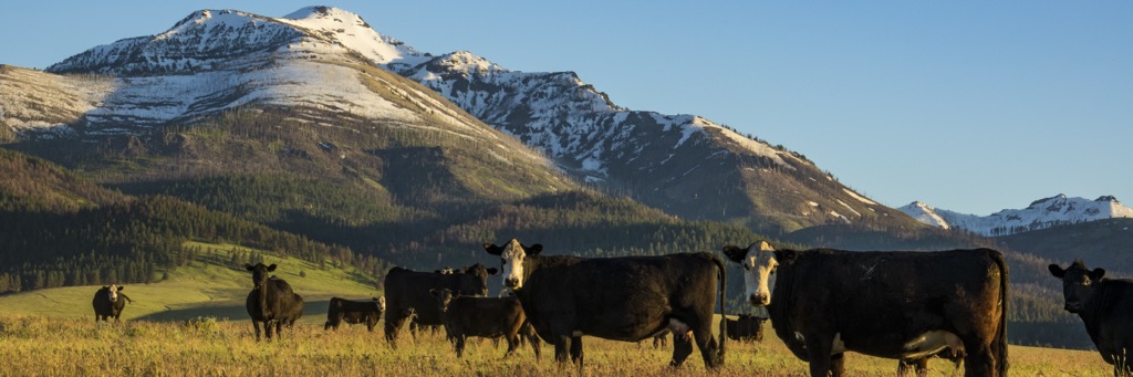
Where to Stay: The Retreat at Silvies Valley Ranch
During this leg of my trip, I stayed at Silvies Valley Ranch. This livestock ranch sits on a staggering 234 square miles (606 sq km) of wilderness, of deeded and leased National Forest and BLM lands, rife with mountain meadows and ponderosa pine forests along the Silvies River.
While the ranch is actually in operation—with around 4,500 head of cattle and several thousand goats—it is also home to “The Retreat” a 34-room eco-resort, and “The Links” golf course, which consists of two reversible 18-hole courses—the Hankins and Craddock Courses—McVeigh’s Gauntlet, a 7-hole ridge course, and Chief Egan, a mountain meadow 9-hole course. Silvies has ranked among America's best public golf courses, so it’s worth checking out if you fancy golfing. On the other hand, our group spent our time shooting six-shooter pistols and snowshoeing.
Where to Eat & Drink: Outpost Pizza Pub & Grill
I had a tremendous burger, “The El Diablo,” at this restaurant in the town of John Day. Don’t miss the fried pickles, either!
Where to Hike: Strawberry Mountains Wilderness & Painted Hills
The Strawberry Mountains are a spectacular subrange of the Blue Mountains south of the John Day River. There are a number of great hikes in the region, but a fan-favorite is the Buckhorn Meadows Trail to Indian Creek Butte (7,887 ft / 2,404 m). This 10.5-mile (17 km) trail takes hikers to the top of the butte, still layered with ash from an ancient volcanic eruption.
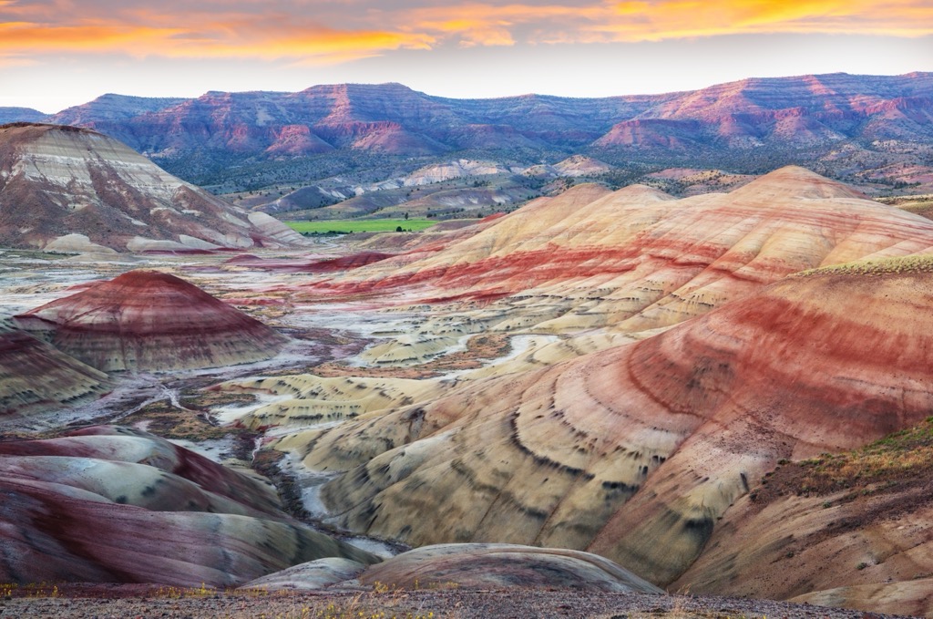
The following day, we also stopped at the Painted Hills in the John Day Fossil Beds National Monument. Similar to the famous “Rainbow Mountain” in Peru (but far less crowded), these hills are striated with varying layers of mudstone, siltstone, shale, and lignite, and the resulting rainbow tableau is truly sublime.
There are a few hikes in the area, and all are relatively short, such as the Carroll Rim Trail (1.6 mile / 2.6 km roundtrip), Painted Hills Overlook Trail (0.5 mile / 0.8 km roundtrip), Painted Cove Trail (0.25 mile / 0.4 km), Leaf Hill Trail (0.25 mile / 0.4 km), and Red Scar Knoll Trail (0.25 mi / 0.4 km).