
Share

Scan the QR code and open PeakVisor on your phone
Scan the QR code and open PeakVisor on your phone
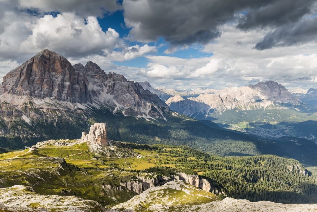
Tofane is a relatively small group of mountains in the Dolomites in northern Italy. It is located in the very heart of the region, making it one of the best natural viewpoints in the Dolomites. In particular, you can enjoy the 360-degree views of the “Pale Mountains” from the highest and the most prominent peak of the group, Tofana di Mezzo (3,244 m / 10,643 ft). In total, there are 12 named mountains in Tofane.
The Tofane Group is located in the province of Belluno in the Veneto region of Italy on the border with the province of Bolzano in the Trentino—Alto Adige / South Tyrol region.
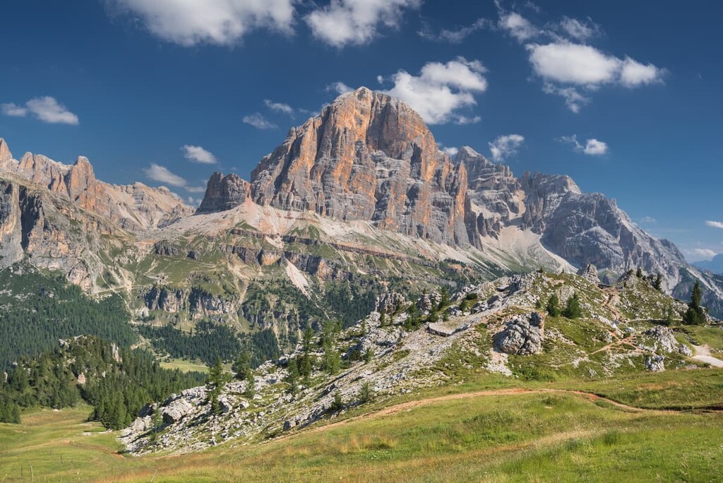
Even if this is the first time you’ve heard of the Tofane, you’ve probably heard of several other nearby attractions that make this region one of the most popular in the Dolomites. I’m talking about the Falzarego Pass, the peaks of Lagazuoi Piccolo (2,835 m / 9,301 ft) and Lagazuoi Grande (2,804 m / 9,199 ft), the rifugio Lagazuoi, the Cinque Torri peaks and the town of Cortina d’Ampezzo. All of these attractions are located within or just a short distance from Tofane.
Last but not least, the Tofane is almost 100 percent located in the Nature Park of Ampezzo Dolomites (Parco naturale regionale delle Dolomiti d’Ampezzo), one of the nine nature parks in the Dolomites alongside the Tre Cime Nature Park and Paneveggio.
Tofane is easiest to reach from Cortina d’Ampezzo, the main capital village in the Dolomites, which is located nearby. You can get to it by cable car, but also, of course, on foot, bicycle, motorcycle, or car. The distance from Cortina to Falzarego Pass is 16.3 km (10.1 mi) or 24 minutes. On a bicycle, it is a 900 m (2,965 ft) climb that involves about 2 hours of very active pedaling.
Shockingly, it’s the cable car—not the bike ride—that’s most attractive to visitors to the region. Actually, there are two of these cable cars:
The fastest way to get to Cortina itself is from Belluno, which, in turn, can be reached from Venice. The whole journey by car takes 2 hours and 35 minutes (176 km / 109.3 mi).
In summer, from June 14 to September 21, the Dolomiti Bus service runs from Belluno to the town and to the Falzarego Pass, and in between them. However, keep in mind that the bus schedule changes every year. So, while you may see schedules in PDF version on the company’s website, be sure to check that it’s the most up-to-date one.
In my opinion, a journey down this road is incredibly beautiful in its own right as it lets you look at the surrounding scenery from the bus window. But of course, for maximum adventure, you’ll need to leave the bus.
The geology of the Tofane Group is similar to that of the region. The Dolomites consist of the mineral of the same name—dolomite rock—which began to form some 230–250 million years ago during the Triassic as a result of the deposits of corals and other sea creatures in the tropical Tethys Ocean.

More specifically, the Tofane consists of the Main Dolomite (Dolomia Principale). It is considered principal because it reaches a greater thickness than other types you can find in other parts of the region. Scientists have also noted that in Tofane you can find some of the oldest dolomite in the region.
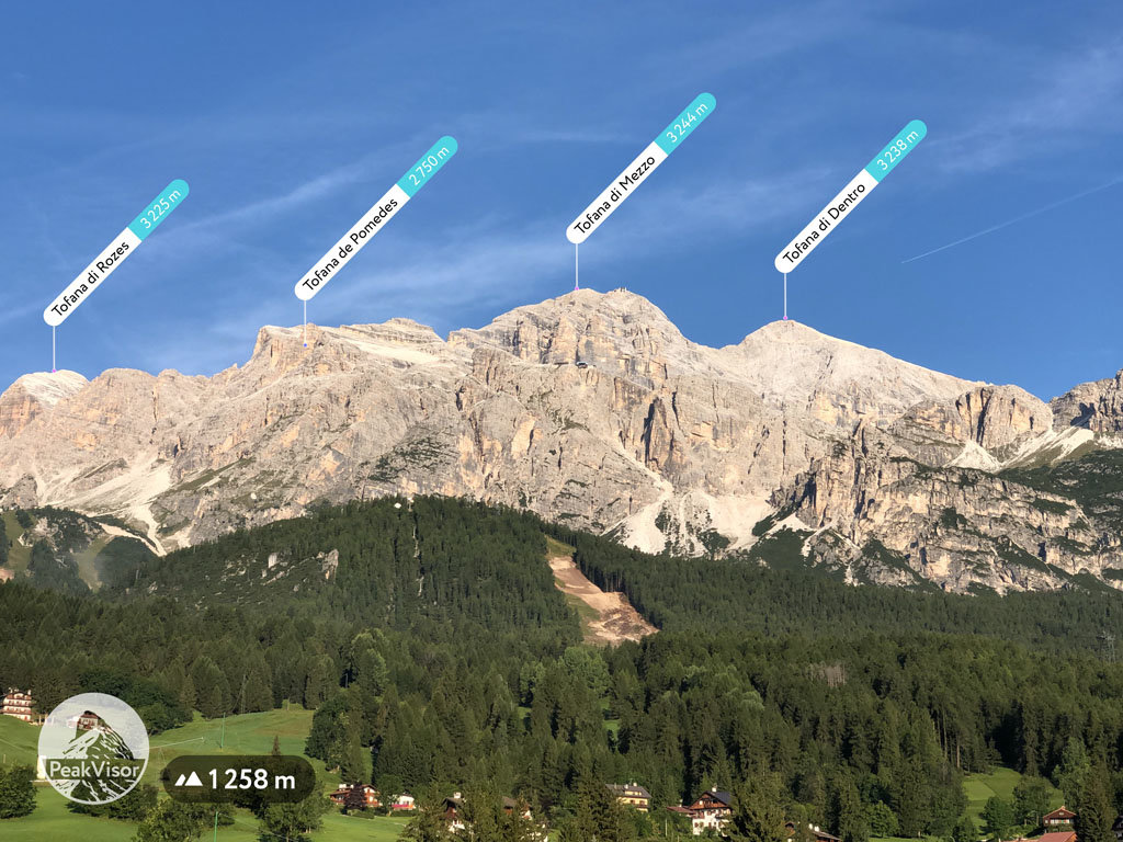
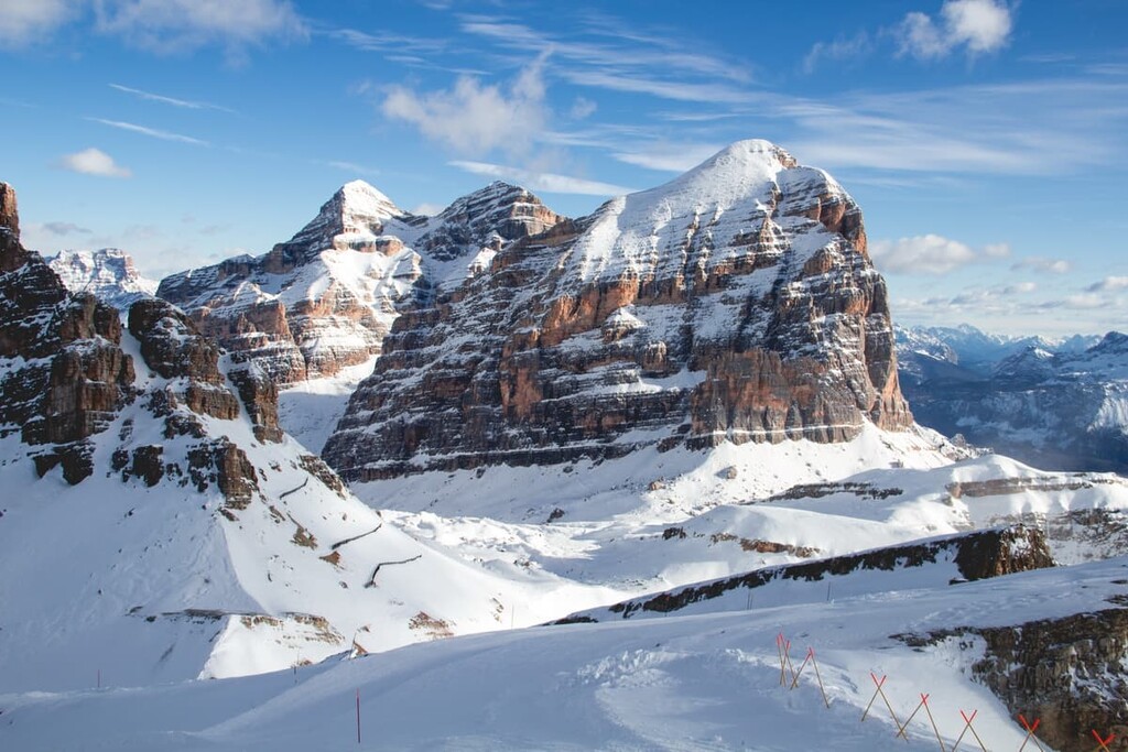
The landscape of the Tofane is dominated by its three highest peaks, all of which look similar to man-made pyramids. These are Tofana di Mezzo (3,244 m / 10,643 ft), Tofana di Dentro 3,238 m / 10,623 ft), and Tofana di Rozes (3,225 m / 10,581 ft).
The first two of these mountains were once covered by small glaciers. However, almost nothing remains today as a result of global warming.
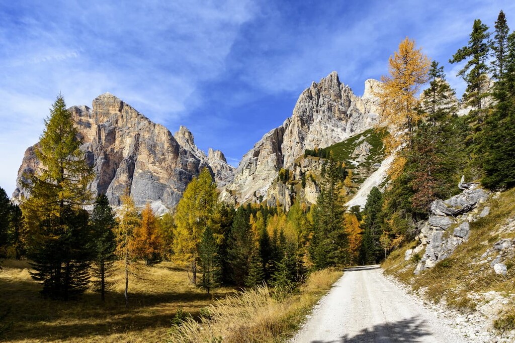
The landscape of the group also cannot be discussed without mentioning Falzarego Pass and the neighboring mountain groups, some of which I have already mentioned. Also, the Tofane is surrounded by three major valleys: the Val di Fanes to the north, the Valle d'Ampezzo to the east, and the Val Travenanzes.
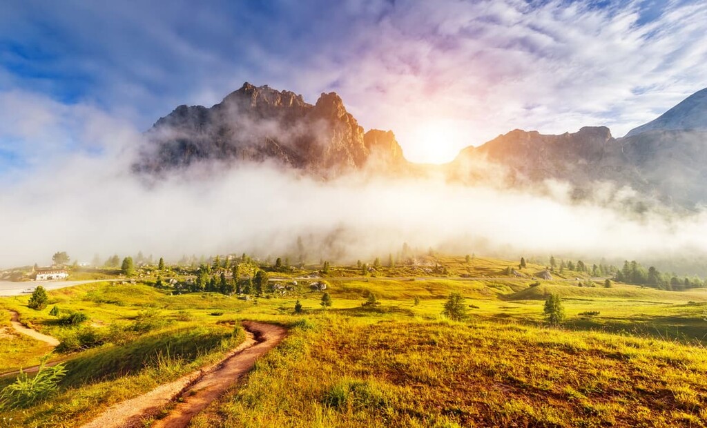
Like everywhere else in the Dolomites, there are also many vast alpine meadows around the Tofane, where cows graze and you can hear the bells ringing on every one of them (so they don’t get lost) even when you are dozens of kilometers (miles) away.
Overall, the scenery of this particular mountain group is one of the best in the region. I visited it in 2013 on a day trip and I can confirm it. It is probably the single point with the highest concentration of panoramic views in the Dolomites. If you have limited time to travel here, but you want to see as much as possible, definitely come to Tofane.
The Tofane Group is quite small when compared to the neighboring groups, such as Pale di San Martino, Sella Group, or Brenta Group. The Tofane also does not have as many peaks as other groups in the Dolomites—only thirteen.
Tofane belongs to a larger group of mountains called Ampezzo Dolomites. These are the mountains in the vicinity of the village of Cortina d'Ampezzo, which also includes the Nuvolau Group, for example.
Important: Do not confuse these mountains also with the Fanes Group, the closest neighbor of Tofane to the west. You could say that they merge with each other if they were not separated by the Forcella Travenanzes and the torrent of the same name. One of its famous peaks of Lagazuoi belongs to the Fanes for sure.
To the north, the group is also bordered by the Fanes Group and the Dolomites of Braies (Dolomiti di Braies / Pragser Dolomiten). To the east, it is the Cristallo Group, and to the south, it is the Nuvolau group, Croda da Lago with its highest peak Cima Ambrizzola (2,715 m / 8,907 ft), also a part of the Dolomiti d’Ampezzo mountains.
The famous Austrian mountaineer Paul Grohmann was the first to climb all three peaks, having done so in 1863, 1864, and 1865. He was also the first to climb many other peaks in the Dolomites, such as Pelmo (3,172 m / 10,408 ft), Tre Cime di Lavaredo (2,999 m / 9,839 ft), and others. Each time he was assisted by local climbers and guides: In Tofane these were Francesco Lacedelli, Santo Siorpaes and Angelo Dimai—all from the Ampezzo area.
Tofana di Mezzo is the highest peak of the Tofane, which is located in the center of the group on the Cortina d'Ampezzo side. It is also the third-highest peak in the region after Marmolada (3,343 m / 10,968 ft) and Antelao (3,262 m / 10,702 ft), called “Queen” and “King” of the Dolomites, respectively. It turns out that Tofana di Mezzo is the princess of Dolomite, right?
As I said, the easiest and fastest way to get up the mountain is by cable car. If this sounds too easy, then take the Via Ferrata Gianni Aglio from lower Punta Anna (2,731 m / 8,960 ft). The path is 2 km (1.2 mi) long with an elevation gain of 513 m (1,683 ft), so it’s no walk in the park.
Tofana di Dentro is the second highest peak in the Tofana Group and it is located next to Tofana di Mezzo
The best way to climb the mountain is from the only bivouac in the Tofane, which is called Baracca degli Alpini at 2,922 m (9,586 ft). It is located just at the base of the summit and it is a small wooden bivouac that was built during the battles in these areas between the Austrians and Italians during World War I. It has 7 beds and a stove but not wood, so bring your own gas burner.
You can also climb between these two highest peaks using a via ferrara.
Tofana di Rozes is the third highest and the most famous peak of Tofane. It is located at some distance from the first two peaks as it is situated closer to Falzarego Pass. From the pass, you can see the peak in nearly all weather conditions.
The summit of Tofana di Rozes is relatively easy to reach on foot from the north side or using the via ferrata from the west. But the mountain is much more complicated to climb from the south. It was first climbed from the south only in 1901, 36 years after the first ascent from the north.
The other 10 highest mountain peaks in Tofane are:
When I first explored the Tofane, I was surprised at how many hiking and climbing trails there are for such a relatively small mountain group. I will briefly tell you about the main treks that are worth checking out:
Two Lakes Trail from Cortina d’Ampezzo is an easy one-day trail in the low mountains in the Amprezzo Valley. It starts and finishes in Cortina, so it’s a great loop trail.
The main attractions on the route, besides the giant peaks of Tofane, are the two small lakes, Ghedina and Drusciè, where you can relax and take a break. The route is suitable for those who do not intend to spend more than one day in Tofane but want to get closer to it and have a bird's-eye view of Cortina at the same time.
This is a challenging route with 1,031 m (ft) of elevation gain in the northern part of the group. It climbs between two mountain huts (rifugio Giussani and rifugio Angelo Dibona) and it features an ascent to the summit of Tofana di Mezzo. Along the way, you will also pass Cima Formenton (2,9285 m / 9,285 ft) and Tofana di Dentro (3,238 m / 10,623 ft) peaks.
The next day, after an overnight stay under the stars in the Dolomites, you can return to the first hut along Trail 403. Doing so creates a loop with plenty of spectacular views along the way.

During the First World War, the mountains of the Tofane Group, the Falzarego Pass, as well as the neighboring Fanes Group, were the scene of fierce battles between Austro-Hungarian and Italian soldiers from May 1915 to July 1916.
The front line of the fighting was located in Tofane. To this day, we can find many trenches, caves, and various military fortifications that were used by soldiers to defend and attack each other during the conflict.
In particular, the historical trail, which runs from rifugio Angelo Dibona to Tofana di Rozes, offers the opportunity to visit the so-called “Castelletto,” which are military tunnels and a gallery located right in the rocks of Tofana di Rozes. From these tunnels, the Italian soldiers defended their positions on the front line.
The path is named after one of the peaks in the Tofana Group, Il Castelletto (8,714 m / 8,714 ft), which for a long time remained with the Austrians, while the Italians took the Tofana di Rozes peak after many attempts. Then, they fought each other on neighboring peaks. The front line was not moved, remaining in favor of Italy.
Important: For this hike, you will also need climbing equipment to pass through 3.5 km (2.1 mi) long via ferrata Giovanni Lipella. You can also continue around the summit of Tofana and Punta Marietta to make a great loop route that lets you visit the historic military tunnels and other important nearby destinations.
The Alta Via 1 is one of the two longest alpine hiking trails in the Dolomites, on par with Alta Via 2. Its total length is 125 km ( mi) and its average travel time is 12 days.
This route doesn’t cross the Tofane Group, but if you start from the very beginning of the trail at the Braies Lake in Val Pusteria in the province of Bolzano / South Tyrol, you will arrive at rifugio Lagazuoi from rifugio Fanes in the Fanes Mountains by day 4.
On the next day, you will cross the Falzarego Passo to rifugio Nuvolau in the Nuvolau Group, all while enjoying great views of the Tofane.

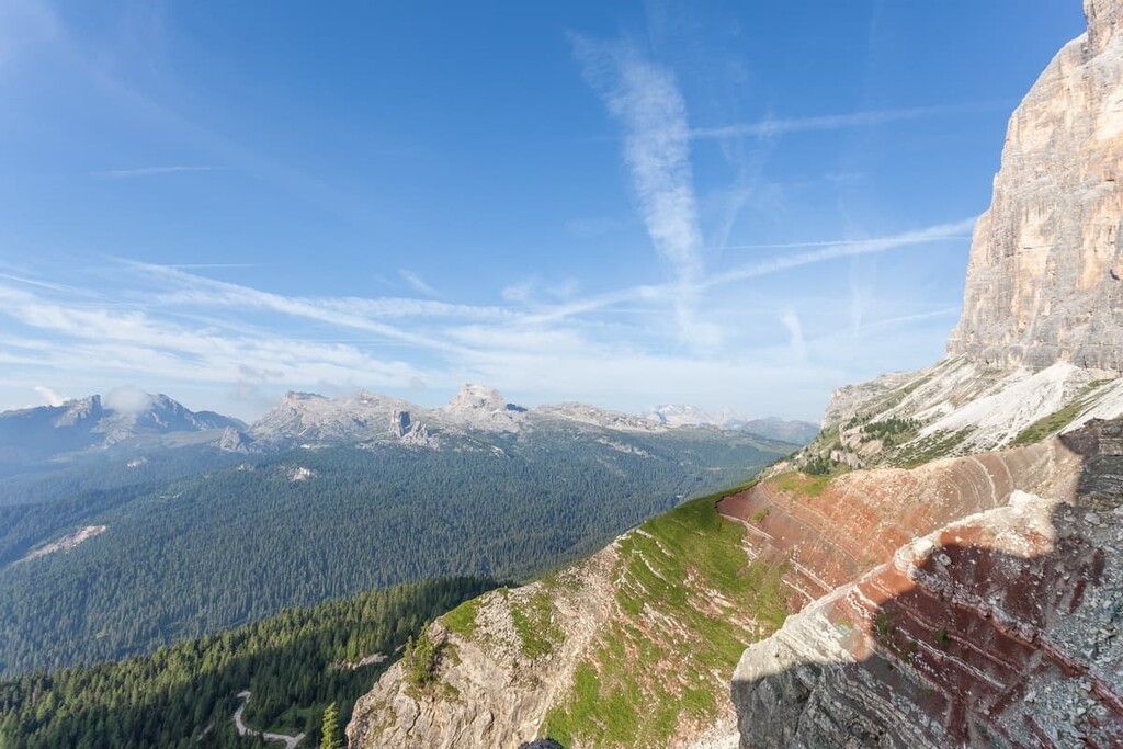
The Geological Trail “Via Ferrata “Astaldi” is arguably one of the most famous via ferratas in the region. It is also a unique geological trail, or, in other words, you can combine rock climbing geologic exploration all into one adventure on this trail.
In particular, on the trail you can find and explore the 220 million-year-old Raibl geological formation. This formation is characterized by thin clay layers painted red between brown and gray rock walls that testify to the marine lagoon that once was here.
Furthermore, this trail lets you walk along a natural terrace at the foot of Tofana di Mezzo, while clinging to a suspended metal rope. That exciting section is why this trail is a via ferrata and, as such, it should not be underestimated.
The ferrata is also one of the oldest in the region, and it is named after Maria Luisa Astaldi, an Italian writer and journalist, who lived in Cortina some time.
Not far from “Sentiero Geologico Astaldi,” there is also another interesting place related to geology: the Grotta di Tofana, a natural cavern in the Tofana di Rozes, 300 m (984 ft) long and up to 10 m (32.8 ft) high. Its uniqueness is that it is also formed of Main Dolomite rather than softer limestone rocks.
Other famous Via ferrata in the Tofane group include Gianna Aglio (Tofana di Mezzo), Formenton (Tofana di Dentro), Giovanni Lipella (Tofana di Rozes), Giuseppe Olivieri (Punta Anna).
Before, and certainly, during your trip to the Dolomites, you can get more practical and inspiring information about Tofane, the Ampezzo Valley, and the Dolomites in general at the official information point located in the center of Cortina d'Ampezzo.
Usually, I try to visit such points to get a free or inexpensive map of the region that you can’t find anywhere else (this map is also a great souvenir). At these visitor centers, you can also get additional information about the natural history of the region and ask the local staff for advice.
Another useful tip: the Info Points don’t sell gasoline or other gear, so find it in advance in the larger towns and cities. You will probably be able to find it in Cortina d'Ampezzo, because there are outdoor stores, but not in other smaller and less popular tourist spots.
Info Point Cortina (Ufficio Informazioni Turistiche)
Corso Italia, 81, 32043 Cortina d'Ampezzo BL, Italy
General opening time: Monday—Sunday from 9:15 am to 12:45 pm and from 3 pm to 7 pm
+390436869086

While hiking or climbing in the Tofane, you will have no problem finding accommodation because there are four mountain huts in this small group. In comparison, in my home mountains of Pale di San Martino, which are much larger in area, there is only one more main hut, and there are eight in total.
So, here’s the list of the mountain huts in the Tofane, where, like in the Dolomites in general, you will wind a bed in a shared room for 4–12 people, breakfast and dinner, a shower, and many nice people to talk with about your adventures:
Do not forget the Baracca degli Alpini bivouac if you want to climb Tofana di Dentro. To reach it from rifugio Cappana Ra Valles (it is only a restaurant without sleeping places) at the cable car station on the way to the summit of Tofana di Mezzo, you will need about two hours and the elevation gain will be about 452 meters (1,482 ft).
Before and after the hike, you will easily find any accommodation in Cortina d'Ampezzo. Just remember that it is more expensive here than in other parts of the Dolomites. For example, in my village of Lamon, you can find a room in a B&B for €60 euros per night for two people. Here, such a room will cost twice as much.
Tofane is known not only as an incredible place for hiking and climbing, but also as a ski resort with a well-developed infrastructure and a rich skiing history.
The range has an extensive ski area that starts right where the town of Cortina d’Ampezzo ends. In total, there are 37 slopes (6 black, 12 red, and 19 blue runs) for a total length of over 40 km (24.8 mi) and 11 lifts (1 gondola,1 cable car, 9 chairlifts).

The ski area can be divided into two parts: The difficult slopes in the higher mountains (Forcella Rossa and the Schuss of the Tofana), and easier pistes in the lower peaks (Socrepes, Pocol, and others). So the Tofane is ideal for all types of skiers. Even if you haven't tried skiing in your life, you can venture here to start.
In 1956, Cortina d’Ampezzo hosted the Winter Olympics, which will return to Tofane in 2026 after a hiatus of 70 years. However, it has also played host to numerous World Cups and World Ski Championships, the most recent of which was here in the winter of 2021.
Learn more about skiing in Tofane on the official website of Cortina d’Ampezzo. It is also one of the 16 resorts that make up the Dolomiti Superski system, so you can use the same ski pass for skiing here and in other places in the Dolomites like Latemar, Pale di San Martino, or Marmolada group.
Check the Tofane ski resorts map on the larger Veneto and Italy ski maps in the World Mountain Lifts section of the site. It includes information about open ski lifts / slopes in the Tofane Group in real-time with opening dates and hours. There are also year-round cable cars, funiculars, cog railways, aerial tramways, and all other types of mountain lifts.
Cortina d’Ampezzo is considered the main tourist town or a village in the Dolomites on a par with the four major cities: Belluno, Trento, and Bolzano.
It is located in the Belluno province at an elevation of 1,224 m (4,016 ft) almost on the border with Austria. So here, no doubt, you will feel like you are in more of an Austrian or Ladin cultural environment than in an Italian one. At the same time, there are plenty of Italian traits throughout the region..
There are 5,842 (2017) people living in the town in an area of 254.51 sq. km (98.27 sq. mi). They mostly speak German and Ladin languages, because the Ampezzo Valley is also one of the five Ladin valleys, where, in addition to Austrians and Italians, the Ladins also traditionally live.

The village has become so popular in recent years because of the magnificent views of the surrounding mountains, the development of skiing, and the many famous people who come here for holidays. Even Hollywood stars were here a couple of times making, for example, "The Pink Panther" movie. Therefore, it is quite an expensive tourist destination compared to other places in the same province.
The town has a huge variety of architectural and cultural attractions, here are just a few of them as an overview of what not to miss when you come here:
The official tourist website: Dolomiti.org.

Explore Tofane with the PeakVisor 3D Map and identify its summits.


