Scan the QR code and open PeakVisor on your phone
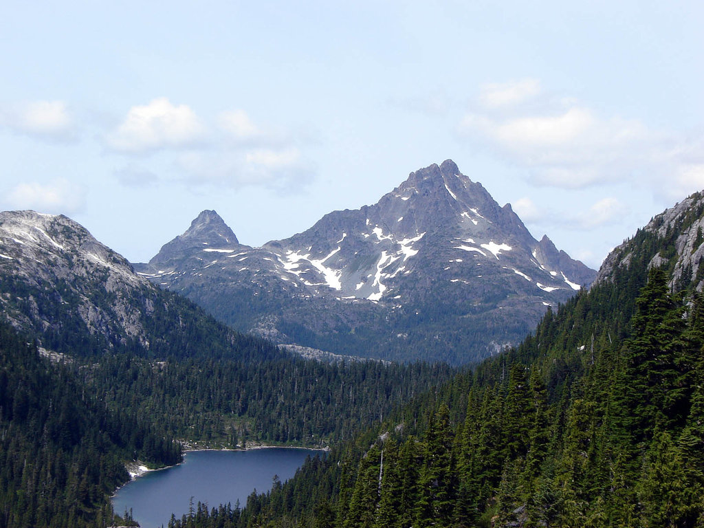
The Karmutzen Range is a collection of peaks located near the north end of Vancouver Island, in British Columbia, Canada. The range is bordered to the south by Nimpkish Lake and has 3 distinct mountains. Tlakwa Mountain is the tallest and most prominent mountain in the range at 1,459 m (4,787 ft) in elevation and with 1,317 m (4,321 ft) of prominence.
The Karmutzen Range is one of the subranges of the Vancouver Island Ranges, which are located on Vancouver Island in British Columbia, Canada. The Karmutzen Range is situated on the north end of the island in the Regional District of Mount Waddington and is located near the Hankin Range, Franklin Range, and the Bonanza Range of the Vancouver Island Ranges.
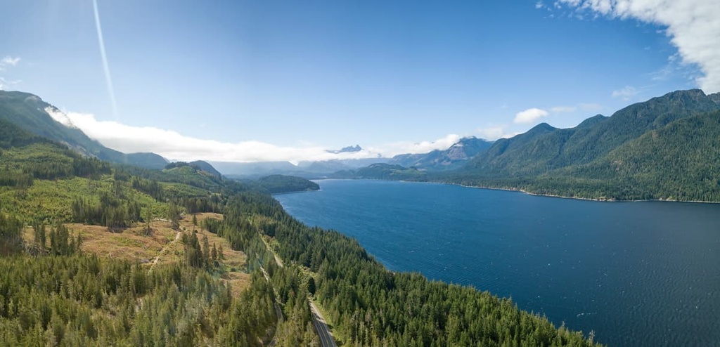
The main way to access the range is to paddle across Nimpkish Lake from Highway 19, or by following the logging roads from the southern part of Lower Nimpkish River Provincial Park.
Nimpkish Lake Provincial Park and Little Huson Caves Regional Park are both located in the west end of the range. Other nearby parks that are worth checking out include:

The Karmutzen Range is part of the Vancouver Island Ranges, which themselves are part of the Insular Mountains. The Vancouver Island Ranges cover Vancouver Island while the Insular Mountains also include the peaks that form Haida Gwaii as well as some of the mountains in the Pacific Ranges of the Canadian Coast Mountains.
The major rock layer of the Karmutzen Range is the Karmutzen formation, which is mostly a sequence of pre-Cretaceous sedimentary and volcanic rocks that have been intruded by granitic batholiths. The Karmutzen formation is likely the thickest visible accreted section of an oceanic plateau in the world.
The formation, which is visible across Vancouver Island and in the Karmutzen Range, contains over 6 km (3.6 mi) of basal sediment-sill complexes, basaltic pillow lavas, pillow breccia, and thick basalt flows. The formation is part of the Wrangellia terrane, which formed as a volcanic island arc in the Pacific Ocean about 300 million years ago.
A major layer of lava erupted about 200 million years ago. However, it was only around 105 million years ago that, while riding upon the Farallon Plate, the Wrangellia Terrane accreted to the western continental margin of North America.
Before the Pleistocene, the Karmutzen Range was subjected to periods of uplift and erosion as rivers found new paths through the range. This period of pre-Pleistocene uplift and erosion created an extremely rugged topography across northern and central Vancouver Island.
The mountains of Strathcona Provincial Park, Schoen Lake Provincial Park, and Nimpkish Lake Provincial Park are examples of the rugged topography that was created during the initial uplift of the Insular Mountains.
During the Pleistocene, the island was subjected to several major glacial events that covered the island in over 1,200 m (4,000 ft) of ice. Local glaciers carved out the bases of the serrated peaks of the Karmutzen Range that stood above 1,200 m (4,000 ft). During this time, these tall peaks stood as monadnocks above the ice sheet.
The range also contains interesting karst topography along the shore of Nimpkish Lake as well as caves that have developed at the west end of the range. Little Huson Caves Regional Park is located at the west end of Karmuten Range and encompasses some of the over 1,600 known caves that are found across Vancouver Island.

As it is located on the trailing end of the Vancouver Island Ranges, the Karmutzen Range doesn’t reach high enough to have a true alpine area. As such, they only contain ecosystems representative of the Mountain Hemlock and Coastal Western Hemlock zones.
The Mountain Hemlock ecology covers the tallest areas of the range and is home to the typical subalpine ecology of the Pacific coast. Mountain hemlock and amabilis fir are the dominant trees in the ecosystem alongside yellow cedar. At the highest elevations of the zone, the trees thin out into a parkland-like mosaic of distinct grassy meadows and stands of trees.
The lower slopes and valleys of the Karmutzen Range are part of the northern rainforests, which are common along the western coast of Canada. Western hemlock and amabilis fir are the dominant trees in this part of the range; however, the Coastal Western Hemlock zone is known for having towering Douglas firs, Sitka spruces, and western red cedars.
The range is an important winter range for the island’s black-tailed deer while the adjacent Nimpkish Lake and its tributaries are vital salmon spawning habitats. Other typical animals of the Karmutzen Range are black bears, the island gray wolf, and bald eagles.

The Karmutzen Range is part of the traditional territory of the Namgis First Nation. The range contains the remains of a former Namgis village and the area was used at different times of the year for fishing, hunting, and gathering resources.
Nimpkish Lake was part of the ancient Grease Trail, which was a trade route across Vancouver Island. The route leads across the island to Kyuquot Sound by way of the Tahsish River, Atluck Lake, and Nimpkish Lake.
The name of the Grease Trail refers to eulachon oil, which is an oil that has long processed from small fish in the region. It was historically traded to inland First Nations for obsidian, copper, furs, and other items, and it was an important commodity to the First Nations of the coast.
Along the slopes of the range, there are culturally modified trees as well as canoe-log trees. The culturally modified trees are typically red cedar which have had part of their bark removed in strips. The cedar strips could have been large enough for use as planks or for building houses. Other times, these strips of bark that were used for making clothing or baskets.

As European settlers arrived on Vancouver Island in the eighteenth century, the eastern side of the island was settled first, followed by then the southern end of the island. The northern end of Vancouver Island does not have the idyllic farmland that’s found to the east and the south and was therefore left unindustrialized until relatively recently.
It was only in 1928 that a railway was built along the Tlakwa drainage to aid in the removal of the large old-growth trees. Thankfully, major forestry in the range was stopped and the second-growth forest is being given time to recover the landscape.
The Karmutzen Range contains plenty of opportunities for hiking and backpacking, fishing, canoeing, kayaking, and caving. The following are the major hiking areas and attractions found in the Karmutzen Range.
From the Karmutzen Main Forestry Road, there are many trails that lead up and into the range.
There are no official trails in the mountain range; however, there are routes that lead across the crest of the range to the summit of Karmutzen Mountain. The trails can be hiked as a day-trip or you can launch a backpacking expedition or venture deeper into the range.
Nimpkish Lake and its namesake provincial park offer opportunities for fishing, swimming, windsurfing, and paddling on the lake.
While there are no developed trails in the park, there are opportunities for hiking and mountaineering on Karmutzen and Tlakwa Mountain. Furthermore, the mountains are known as good locations for backcountry skiing and ski touring.
Located at the south end of the Karmutzen Range, Little Huson Caves Regional Park is home to some short hiking trails that take you to see some fascinating caves. The park has 15 distinct caves to visit, each of which has a unique name, such as the “fern” cave, “river” cave, shelter cave, and bridge cave.

The park is well suited to hikers of all ages, and it offers the opportunity to enjoy emerald-colored waters, fun caves, limestone arches, rock platforms, swimming spots, and picnicking spots. The park is located on the shore of Little Huson Lake and is just a short drive off of Highway 19.
Situated near the north end of Vancouver Island, the Karmutzen Range is one of the northernmost named ranges of the Vancouver Island Ranges. The following are some of the main cities located near the range that offer accommodation and services to further your adventures in the mountains:
Nestled along the east coast of Vancouver Island, the town of Campbell River is located about 170 km (102 mi) south of the Karmutzen Range, along Highway 19. Campbell River has many great places to stay, fantastic places to eat, and some incredible beaches for relaxation.
Some of the hikes and trails near Campbell River include the Campbell River Lookout Trail, the trail to Mount Menzies, and the Quinsam River Hatchery Trail. The city is also located close to some great recreational and hiking areas such as Strathcona Provincial Park, Schoen Lake Provincial Park, Mount Arrowsmith Massif Regional Park, and Elk Falls Provincial Park.
Elk Falls Provincial Park has a well maintained trail that leads through incredible forests filled with massive red cedars, Douglas firs, and bigleaf maples. There are several vantage points along the trail where you can see the stunning Elk Falls, including a suspension bridge that spans the canyon.
Port McNeill is home to the regional offices of the Regional District of Mount Waddington and is located about 5 km (3 mi) to the east of the Karmutzen Range. The primary industries in Port McNeil are logging and tourism. It is often considered to be the gateway to the scenic islands of the Broughton Archipelago.

Port McNeill has regular ferry service to Alert Bay on Cormorant Island and Sointula on Malcolm Island. The town is also home to the Port McNeill Airport, which is the regional airport for the north end of Vancouver Island.
The seaways and wilderness areas of north Vancouver Island are beautiful and full of opportunities for adventure. Some of the amazing places to visit near Port McNeil include the scenic islands of the Broughton Archipelago. You can also check out Nimpkish Lake Provincial Park, Little Huson Caves Regional Park, and the beautiful Cape Scott Provincial Park during your visit to the area.