Scan the QR code and open PeakVisor on your phone
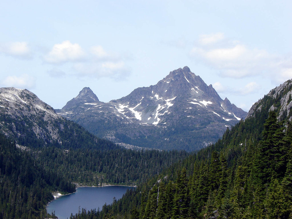
Located along the Tsitika River on the northern end of Vancouver Island in British Columbia, Canada, Lower Tsitika River Provincial Park is a protected area that encompasses part of the Franklin Range. There are only 3 named mountains in the park: Wosscairn (1,571 m/5,154 ft) and Mount Sir John (1,451 m/4,760 ft).
Lower Tsitika River Provincial Park is a protected area that’s located along the eastern coast of northern Vancouver Island in the Canadian province of British Columbia.
Established in 1995, the park encompasses over 37 square kilometers (14 sq. mi) of terrain in the Regional District of Mount Waddington. It is one of the few protected areas on Vancouver Island that includes both low-lying valleys and high-elevation alpine tundra within its boundaries.
The park was established in order to create a larger contiguous protected area that included several previously established ecological reserves. Nowadays, Lower Tsitika River Provincial Park is also located adjacent to Robson Bight Ecological Reserve, Tsitika Mountain Ecological Reserve, and Mount Darby Ecological Reserve.
Other nearby parks and reserves include:
Lower Tsitika River Provincial Park is situated at the southern end of the Franklin Range, which is a subrange of the Vancouver Island Ranges. The Vancouver Island Ranges are themselves a subrange of the Insular Mountains, which form parts of the mainland mountains in southwestern British Columbia, southern Alaska, Vancouver Island, and the archipelago of Haida Gwaii.
The Insular Mountains formed from an ancient terrane called Wrangellia and they currently feature many different geologic structures. Wrangellia’s origin story begins over 300 million years ago when lava erupted from a rift in the floor of the Pacific Ocean.
After this lava solidified, sediments began to accumulate on top of this volcanic rock over the course of millions of years. This accumulation occurred until about 230 million years ago when a massive series of eruptions that lasted for about 5 million years created the island of Wrangellia.
About 145 million years ago, during the Late Jurassic and Early Cretaceous, Wrangellia’s tectonic plate subducted beneath the western edge of North America. As the plate slid beneath the continent, the Wrangellia terrane accreted to the continental margin.
The accretion of exotic terranes such as Wrangellia occurs because these island arcs are relatively buoyant when compared to the crustal plates on which they reside. Their buoyancy allows them to float above the magma as their tectonic plate slides beneath another. As a result, the exotic terrane is forced to collide into and weld onto the continent.
Wrangellia’s collision also caused a major tectonic uplift in the interior of the continent, which helped create the Rocky Mountains. This collision was also responsible for much of the uplift of the Columbia and Coast Mountains.
As the island arc accreted to the edge of the continent, the terrane was compressed, folded, and broken apart. These geologic events instigated the formation of the Vancouver Island Ranges. The final uplift of the Vancouver Island Ranges, which includes the Franklin Range, was caused by the collision and accretion of the additional Pacific Rim and Crescent terranes, which occurred 60 and 40 million years ago, respectively.
By this time, the major topographical features of Lower Tsitika River Provincial Park had already formed; however, the Pleistocene glaciers had yet to leave their mark on the park. During the Pleistocene, it is likely that the glaciers that formed on the peaks of what is now Strathcona Provincial Park spread out across the island and down the valley of the Tsitika River.
Throughout this period, there were several occurrences of ice sheet expansion from the mainland, all of which helped to cover Vancouver Island in over 1 kilometer (0.6 mi) of ice over the course of millions of years. During their retreat, the glaciers also deposited massive amounts of debris and sediment across the landscape, leaving the Tsitika River Valley covered in layers of glacial sediment.
Mountain hemlock and amabilis fir are the dominant tree species that are found on the upper slopes and peaks of the Franklin Range, alongside some stands of yellow cedar. The park’s highest summits of Wosscairn and Mount Sir John feature barren rocky slopes that transition into parkland-like mosaics of distinct grassy meadows and stands of trees as you move toward the lower elevations.
Since it is located at the northern end of Vancouver Island, the Franklin Range is where the elevation of the island’s mountains begins to taper off. As such, there are relatively few areas of the region’s typical alpine ecosystems in the range.
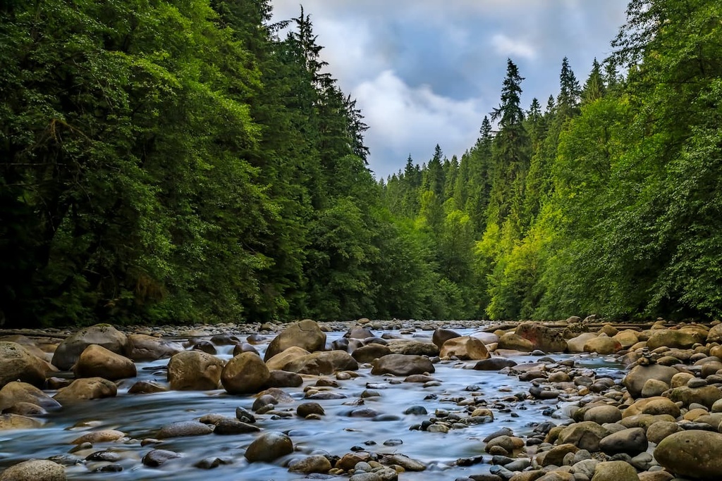
The lower elevation slopes and valleys in the park that are located along the Tsitika River are covered in forests typical of the Western Hemlock ecosystems, which are part of the northern temperate rainforests. Western hemlock and amabilis fir are the dominant tree species that are found on the lower slopes of the park.
Most visitors to the provincial park will also recognize the region’s giant red cedars, towering Douglas firs, and massive Sitka spruces, which are all major features of any of the old-growth forests on Vancouver Island. The old-growth forests in the park are found in the area surrounding the Tsitika River estuary, which is closed off to the public to preserve the ecological integrity of this valuable wildlife habitat.
In conjunction with Robson Bight Ecological Reserve, Tsitika Mountain Ecological Reserve, and Mount Darby Ecological Reserve, most of the Tsitika River watershed that’s located both in and around the Lower Tsitika River Provincial Park has been protected from development. As such, the area is home to many different species of wildlife.
The park is home to all five species of Pacific salmon, as well as steelhead trout, cutthroat trout, and Dolly Varden char. It is also possibly the site of some eulachon spawning grounds. The river is especially important as it features a large summer run of steelhead trout. In fact, the river is home to the only significant run of steelhead trout remaining along the eastern coast of the island.
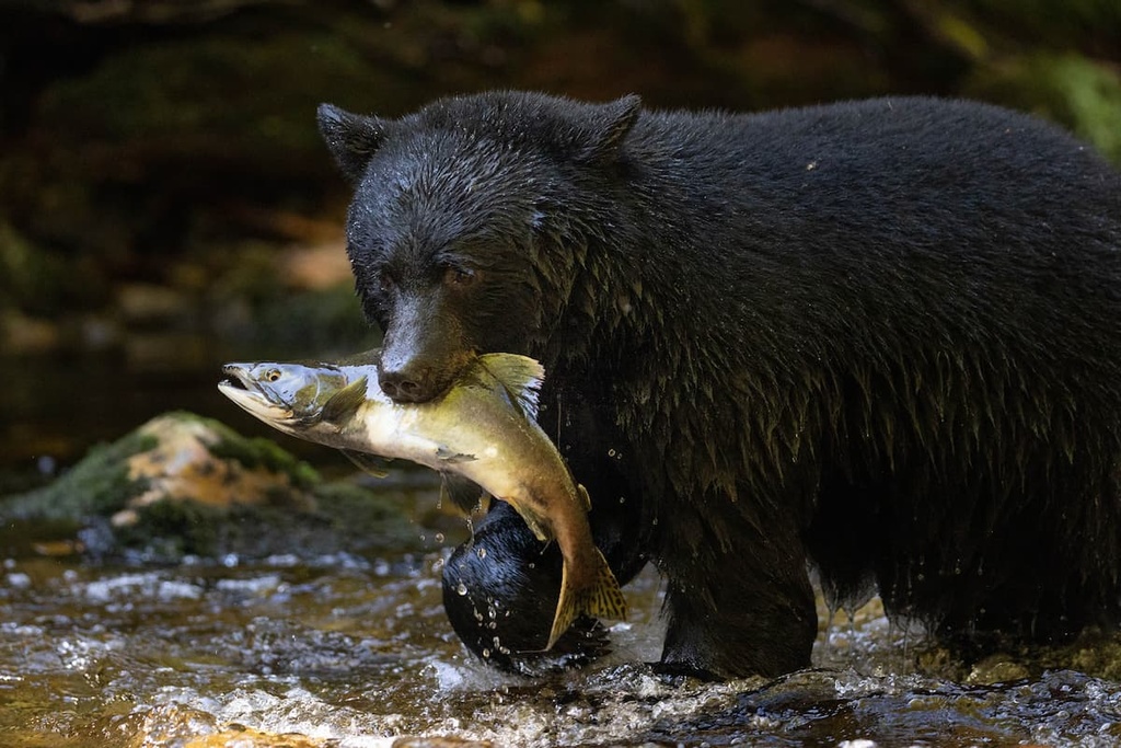
The Tsitika River and its estuary are significant habitat areas for the endangered marbled murrelet, and they serve as important breeding and foraging grounds for the northern goshawk. Additionally, the park is an important wintering area for Roosevelt elk, and it is inhabited year-round by black-tailed deer, wolves, black bears, and many other small mammals and bird species.
Vancouver Island is divided into three regions that have been traditionally occupied by the Coast Salish, Nuu-chah-nulth (Nuučaan̓ułʔatḥ), and the Kwakiutl (Kwakwa̱ka̱ʼwakw). Lower Tsitika River Provincial Park is located along the border of the traditional territory of the Coast Salish people, who traditionally reside on the southern end of the island, and the Kwakiutl, who traditionally reside on the northeast end of Vancouver Island.
Within the borders of Lower Tsitika River Provincial Park, there are the remains of an ancient village site as well as a number of culturally significant areas for many First Nations. The coastal area along the eastern slopes of the Franklin Range and the area along the Tsitika River both have especially long histories of use and occupation by First Nations.
Archeological evidence suggests that Vancouver Island has been home to humans for at least 13,000 years. Many First Nations in the region have a cultural legend that tells of a major flood that occurred in the area. While many people were washed away by this flood, some survived the disaster by retreating to canoes that they had tied to trees.
Changing sea levels since the Pleistocene have made it difficult to find evidence of older human habitation in the region. Ancient First Nations communities in the region tended to cluster along the coast; however, at the beginning of the Holocene, sea levels were significantly lower than they are today.
As a result, many places that would have been settled by First Nations during these periods are now underwater. Indeed, some cultural sites, such as ancient coastal fisheries, have been uncovered in the waters near Haida Gwaii.
Lower Tsitika River Provincial Park was established in 1995. It was created as a part of a larger land management strategy detailed in the Vancouver Island Land Use Plan. The current Lower Tsitika River Provincial Park encompasses land that was previously part of three other ecological reserves (Tsitika Mountain, Mt. Derby, and Robson Bight/Michael Bigg).
Despite its proximity to several major communities and cities on Vancouver Island, Lower Tsitika River Provincial Park receives relatively few visitors. This is likely because one of the most scenic areas of the park, the Tsitika River estuary, is closed to hikers.
That said, there are worthwhile hikes and scrambles in the park for visitors to enjoy. Both of the peaks in Lower Tsitika River Provincial Park are accessible as a hike or a scramble. The hike to the summit of Mount Sir John is relatively straightforward and gentle; however, Wosscairn requires a bit of a scramble to reach the summit.
From the summits, hikers are rewarded with views of the Franklin Range, Bonanza Range, Johnstone Strait, and Robson Bight. The summit of Wosscairn literally has a giant cairn on the top, which was likely built by the 1931 survey crews so that they could use the cairn to make triangulation calculations from nearby peaks.
The northeastern coast of Vancouver Island is beautiful and rugged. There are many mountain ranges, dense forests, and incredible lakes and rivers in this part of the island. Indeed, Lower Tsitika River Provincial Park is only one of the many outdoor recreation destinations that exist in this more remote section of Vancouver Island.
Nevertheless, there are a number of cities and communities where you can stay or stock up on supplies during your trip to Lower Tsitika River Provincial Park. The following are some of the major towns and cities that offer services for visitors of Lower Tsitika River Provincial Park and the other northern island wilderness areas.
Campbell River is the largest community that’s located on the northern end of Vancouver Island. It is often considered to be the gateway to the Discovery Islands and the northern Vancouver Island wilderness.
The community of Campbell River is situated along the Campbell River and the Georgia Strait where it offers stunning views of the ocean to the east and the mountains to the west. It is located about 140 km (86 mi) away from Lower Tsitika River Provincial Park.

There are many beaches that are located both in and around Campbell River. On clear days, all the beaches in the region offer stunning views of the Georgia Strait, the Pacific Ranges on the mainland, Quadra Island, and Cortes Island.
One of the most popular hiking destinations from Campbell River is the scenic Elk Falls Provincial Park. Here, surrounded by massive Douglas firs, great maples, red cedars, and western hemlocks, the Elk River tumbles spectacularly over a cliff and into the river below. Visitors can view the falls from one of the park’s many viewing platforms and from the suspension bridge that traverses the Elk River.
While there are many great hikes and walks to enjoy both in and near the city, Campbell River is also the gateway to the incredible wilderness of northern Vancouver Island. Strathcona Provincial Park, Mount Arrowsmith Massif Regional Park, and Schoen Lake Provincial Park are all located only a relatively short drive from the city, and if you hop onto the ferry from Campbell River, you can even explore the Discovery Islands.
For example, Quadra Island is easily seen from the city and is located just a short ferry ride away. Furthermore, once on Quadra Island, visitors can take another ferry to Cortes Island where you can hike through the picturesque Ha’thayim Marine Provincial Park.
To fully appreciate all that the Discovery Islands have to offer, consider staying at hotels or campsites in Campbell River so you can take a couple of days to travel through the region.
Thanks to its regular ferry service to Alert Bay on Cormorant Island and Sointula on Malcolm Island, Port McNeill is the gateway to the scenic islands of Broughton Archipelago. The town is located about 50 km (30 mi) to the northwest of Lower Tsitika River Provincial Park on the northeastern shores of Vancouver Island.

While the town of Port McNeill is quaint and beautiful in its own right, most visitors make an effort to visit the scenic islands of the Broughton Archipelago while in the area. Within the archipelago, there are several marine provincial parks that you can visit to go kayaking, SCUBA diving, and fishing.
From Port McNeill, you can also check out Nimpkish Lake Provincial Park and the beautiful Cape Scott Provincial Park. The wilderness, beaches, and seaways of north Vancouver Island are all beautiful, and they are full of opportunities for adventure for anyone who takes the time to travel to the region.