Scan the QR code and open PeakVisor on your phone
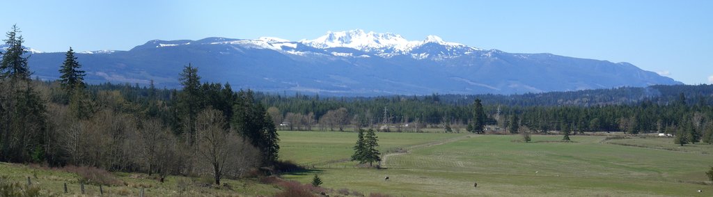
Mount Arrowsmith Massif Regional Park is a protected area located in the Regional District of Nanaimo, on Vancouver Island of British Columbia, Canada. The 13 square kilometer (5 square mile) regional park has two peaks, Mount Arrowsmith and Mount Cokely. Mount Arrowsmith is the tallest and most prominent of the two peaks, with 1,891 m (5,968 ft) of elevation and 1,426 m (4,678 ft) of prominence.
The Mount Arrowsmith Massif Regional Park is located on the eastern side of Vancouver Island in British Columbia, Canada. It contains two peaks: Mount Arrowsmith and Mount Cokely.
The Mount Arrowsmith Massif Regional Park is situated in the Regional District of Nanaimo. It borders Mount Arrowsmith Regional Park in the Alberni-Clayoquot Regional District.
The park is accessible via private logging roads or by hiking the Arrowsmith CPR Regional Trail. However, taking the trail requires hiking through the Arrowsmith Regional Park.
While driving to the park, you’ll likely pass other parks, such as MacMillan Provincial Park with the stunning Cathedral Grove. You may also pass Little Qualicum Falls Provincial Park along Highway 4 on your way to the Cameron Main Connector logging road.
Mount Arrowsmith is one of the many mountains of the Vancouver Island Ranges. The peaks in the ranges are part of the Wrangellia terrane of the Insular Mountains. The Wrangellia terrane started forming about 380 million years ago on the floor of the Pacific Ocean as a result of undersea volcanic eruptions.
During this time, marine sediments were deposited over the initial lava flows. This process continued until about 200 million years ago when the volcanoes once again erupted covering the area again with a tremendous layer of lava. This land mass was part of the Insular Islands, which collided with the west coast of North America about 100 million years ago.
During the collision, the terrane was pressed against the continental margin, causing parts of it to buckle. Meanwhile, other parts of this land mass crumbled and formed deposits of rock on the ocean floor. The mountains of the Vancouver Island Ranges were lifted up during this collision, creating peaks such as Mount Arrowsmith.

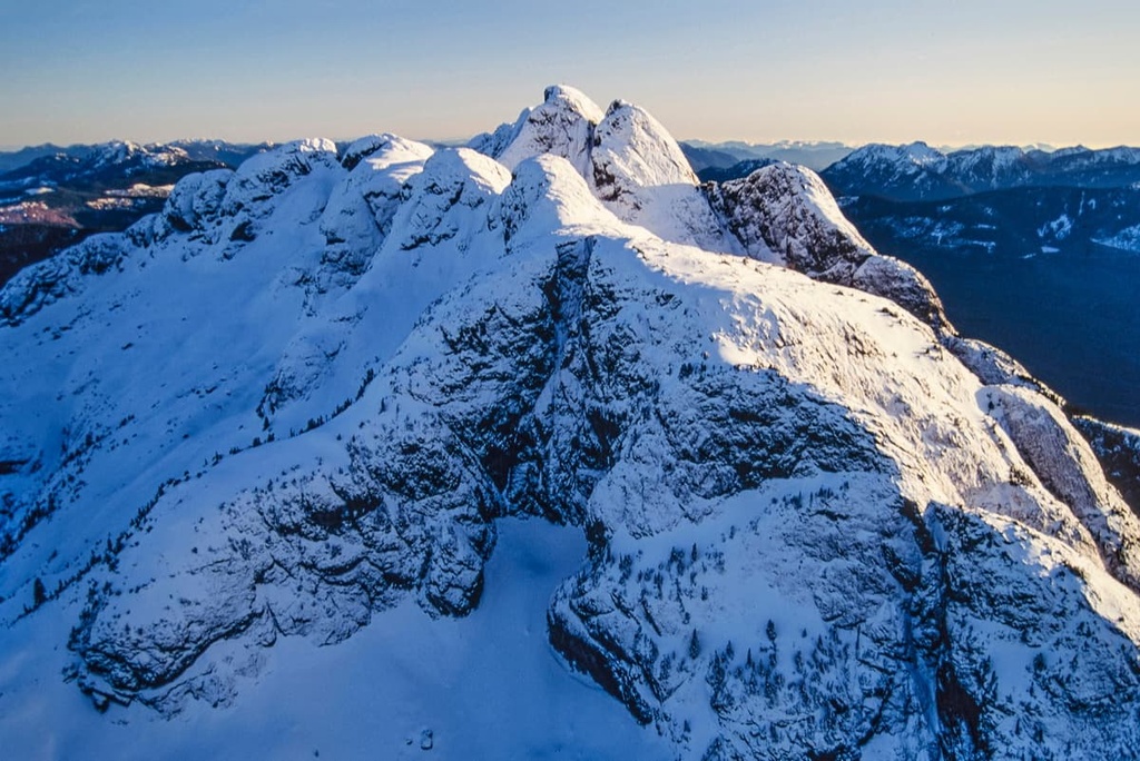
Mount Arrowsmith and Mount Cokely consist mostly of basalt and pillow lava, which are common across the mountains of Vancouver Island. During the Pleistocene, the mountains were heavily glaciated with only the tops escaping the grinding of the ice, creating the sharp, rugged peaks, deeply notched couloirs, and the cirques on the north and northwestern sides.
Mount Arrowsmith Massif Regional Park lies in the Coastal Western Hemlock, Mountain Hemlock, and the Coastal Mountain-heather Alpine ecological zones.
The forests in the park are filled mainly with hemlock and fir, with cedars in the lower elevations and Douglas fir growing on the drier sites. The forests dwindle toward the peaks in the park, where the heather-filled parkland transitions to the alpine.
White tailed ptarmigans inhabit the high ridges while cougars, black bears, wolves, elk, and black bears inhabit the slopes and valleys of the park. The endangered Vancouver Island marmot previously had colonies on the mountain; however, their populations have dwindled to the point where their whistles are heard only by the most fortunate of hikers.
The alpine area of the Mount Arrowsmith Massif is significantly isolated from other alpine areas of the Vancouver Island Ranges, creating a pocket of plants and animals that’s not commonly found elsewhere. The only Lewisia pygmaea ever found on Vancouver Island was first found on Mount Arrowsmith in 1915 and rediscovered again in 2008.

Mount Arrowsmith has towered over countless generations of human settlements on Vancouver Island. The mountain is located on the traditional territory of the Coast Salish First Nations. While there are no archaeological sites on the mountain, it is believed that First Nations occasionally hunted marmots on Mount Arrowsmith.
The mountain has held the interest of settlers since the late nineteenth century, when in 1887, John Macoun, a naturalist, made the first recorded ascent of the peak by a person of European descent. The mountain has since drawn in geologists, surveyors, botanists, and famous mountaineers.
In 1910, the Canadian Pacific Railway built a tourist chalet on the east end of Cameron Lake, which is located to the north of Mount Arrowsmith. A pack trail was completed by 1912, which connected the chalet to an overnight hut on the slopes of Mount Cokely. From the hut, visitors could easily ascend Mount Cokely or attempt the more challenging Mount Arrowsmith.
Logging roads were built to access the adjacent lands. This also made it easier to get to Mount Arrowsmith, so much so that it actually became a very popular destination for skiing, hiking, and climbing. There are still many user-maintained huts on the mountain; however, the towers and ski hill operations were completely removed from the mountain in 2005.

While Mount Arrowsmith Massif Regional Park is a rather small area, it is part of a regional system of parks and protected spaces, with connecting trails. The following are some of the popular trails in and to Mount Arrowsmith Massif Regional Park:
The CPR trail was built between 1910 and 1912 to connect the chalet at Cameron Lake to the backcountry hut on the slopes of Mount Cokely. The well-maintained trail is a 9.3 km (5.6 mi) return trail with 785 m (2,574 ft) of elevation gain and is considered difficult; however, the views are highly rewarding and worth the effort.
The trail to the summit of Mount Cokely starts from the logging road on the eastern slopes of the mountain.
The trail rises 549 m (1800 ft) in only 2.5 km (1.5 mi) to the summit, and, as such, it is considered to be a difficult hike. There are gorgeous views of Mount Arrowsmith, Qualicum Beach, Parksville, Port Alberni, and the Lasqueti and Texada islands along the trail.

There are several trails that make their way to the summit of Mount Arrowsmith. One of these trails is the Judges Route.
The Judges Route is a 3 km (1.8 mi) long grind that rises 1,016 m (3,332 ft) to the summit of Mount Arrowsmith. There are diverging paths along the slopes; however, if you keep heading toward the summit, you shouldn’t have any difficulty with route finding.

Mount Arrowsmith Massif Regional Park is a beautiful and unique wilderness area on the southern half of Vancouver Island. The park is in the Regional District of Nanaimo and there are several cities nearby as well as many other beautiful provincial and regional parks. The following are some of the cities located near Mount Arrowsmith Massif Regional Park:
Nanaimo is a city on the east coast of Vancouver Island. It is one of the primary ports for ferries bringing passengers from mainland British Columbia.
In addition to the beautiful coastline and wilderness areas around the city, Nanaimo, British Columbia is the home of the Nanaimo bar, a delicious treat that features yellow custard sandwiched between chocolate ganache and a coconut-graham crust.

Avid enthusiasts of the Nanaimo bar can check out the Nanaimo Bar Trail, which lists stops for various takes on the local treat. After touring Nanaimo Bar Trail, you might want to burn some calories on Gordie’s Trail up Mount Benson, the Mount Benson Loop, Westwood Lake Trail, or the Cable Bay Nature Trail.
Parksville is a coastal community that is popular for the beautiful beaches that grace its shores. Rathtrevor Beach Provincial Park is a beautiful park with many campsites, a BMX pump track, stunning rocky beaches, peaceful woodlands, and long tidal sand flats to play on and beachcomb.
The community of Parksville has stores and services for all your needs as well as plenty of restaurants serving fresh seafood and other fare for those days you don’t want to cook for yourself. Parksville is also close to the community of Coombs, which has the popular Goats on the Roof store, as well as trailheads to many beautiful riverside and forest hiking trails.
Some of the popular hiking areas around Parksville include Rathtrevor Beach Provincial Park, Englishman River Falls, Cathedral Grove, and Mount Arrowsmith Regional Park.

Port Alberni is located at the head of the Alberni Inlet, on the west coast of Vancouver Island, British Columbia.
The first sawmill in the town was built in 1860. Afterward, milling and forestry became the major employers of the region. While milling and logging are still integral to the local and regional economy, Port Alberni is shifting to more of an environmental focus in order to draw in and capitalize on tourism to the area.
Port Alberni is a good jumping off point for many outdoor activities. Marine and freshwater fishing, hiking, kayaking, and mountain biking are all activities that can be easily enjoyed from the community. There are several hiking trails in Port Alberni and over a hundred in the surrounding valley and mountains.
Some of the popular hikes in the area are the Horne Lake Trail, Log Train Trail, and the Inlet Trail. Mount Arrowsmith is located nearby, too, if you want to hike the Saddle Trail, or you can climb to the summit. Port Alberni is the gateway to the rugged and wild west coast of Vancouver Island and there are also many activities to enjoy in the area.