
Scan the QR code and open PeakVisor on your phone
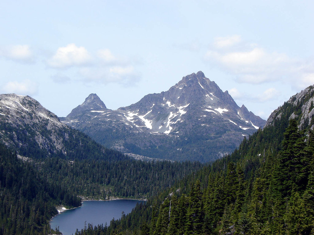
Located on the northern end of Vancouver Island in British Columbia, Canada, Woss Lake Provincial Park encompasses pristine old-growth forested slopes and an alpine wilderness area. The alpine area of the region is centered around Rugged Mountain (1,861 m /6,106 ft), which is the tallest and most prominent of the park’s 9 named peaks.
Woss Lake Provincial Park contains 6,634 ha (16,392 acres) of land on the northern end of Vancouver Island in British Columbia, Canada.
The park includes the intact watershed of Rugged Mountain, which is the tallest and most prominent of the park’s nine peaks. It also encompasses a large portion of the Haihte Range, which is a subrange of the Vancouver Island Ranges.
The park is accessible by air, boat, and by land. There are many logging roads in the region that reach the park’s boundaries. Meanwhile, the peaks and glaciers of Rugged Mountain are typically approached by taking Zeballos Road to the Nomash River Valley.
The park is one of many protected areas in the northern part of Vancouver Island. Some of the other nearby parks in the region include:
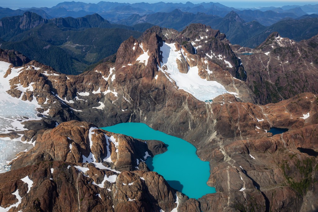
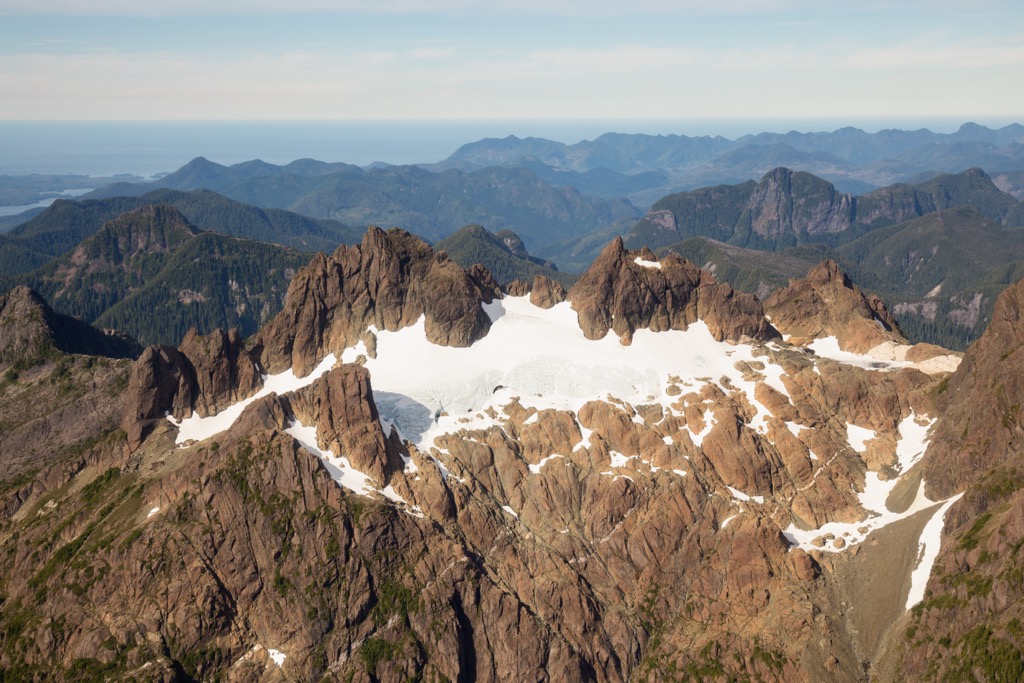
Rugged Mountain is the tallest and most prominent mountain in Woss Lake Provincial Park. The peak stands 1,861 m (6,106 ft) above sea level and has a breathtaking 1,567 m (5,141 ft) of prominence, making it one of the few ultra-prominent peaks on Vancouver Island.
The massive Rugged Mountain is the tallest peak in the Haihte Range, which is a subrange of the Vancouver Island Ranges. The Haihte Range is home to some of the largest remaining glaciers on Vancouver Island.
The mountains of Vancouver Island formed during several events, the first of which was the creation of the actual landmass that comprises the island and mountains. In fact, Vancouver Island consists primarily of a landmass called the Wrangellia terrane.
Wrangellia formed over the course of millions of years as lava erupted under the Pacific. This lava continued to erupt until a massive island arc was created. The most notable part of the terrane is a 6 km (3.6 mi) thick layer of basaltic and pillow lavas that erupted over a period of about five million years.
Outboard terranes, like Wrangellia, move across the oceans according to the movement of their underlying tectonic plates. When an oceanic and continental tectonic plate collide, the denser oceanic plate will typically subduct beneath the continental plate; however, the buoyant island arcs and microcontinents will be generally scraped off their plate and adhered to the edge of the continent.
As such, Wrangellia accreted to the western edge of North America as its tectonic plate slowly, yet violently, submerged below the North American plate. The Alaskan panhandle, Haida Gwaii, Vancouver Island, and many of the coastal islands off the coast of British Columbia are all part of the Wrangellia terrane.
While some of the mountains of the Vancouver Island Ranges started forming from this initial tectonic collision with North America, most of the peaks reached their highest points when two additional outboard terranes collided with Vancouver Island.
The Pacific Rim terrane and the Crescent terrane collided with the west coast of Vancouver Island about 60 million years ago and 45 million years ago, respectively.
The Pacific Rim terrane consists of the lands that are now mostly protected as part of the Pacific Rim National Park Reserve. The Crescent terrane collided with the southern end of Vancouver Island and was responsible for lifting the Saanich Peninsula above sea level.
Most of the rocks in the Vancouver Island Ranges, including the Haihte Range of Woss Lake Provincial Park, are volcanic in origin. The peaks contain examples of volcanic and igneous rocks. In the range, you can also find rocks that were metamorphosed due to the intense heat and pressure of the volcanism, subduction, and accretion events that the region experienced over the course of hundreds of millions of years.
Furthermore, the Haihte Range is home to some of the largest remaining glaciers on Vancouver Island. These glaciers initially formed during the Pleistocene when a general cooling of the Earth created the conditions necessary for the establishment of the Cordilleran and Laurentide ice sheets that covered most of Canada for millions of years.
Vancouver Island was covered from coast to coast with ice throughout many different intervals during the Pleistocene. Many of the island's original glaciers formed and flowed from the tallest peaks on the island, such as those around Golden Hinde in Strathcona Provincial Park.
These ice sheets were responsible for creating much of the topography of the island that we see to this day. They also deposited a large amount of glacial debris in the island’s lowlands. Furthermore, these glacially carved valleys and fault lines are now home to many of the island’s famous lakes.
The ecosystems of Woss Lake Provincial Park extend from the alpine areas surrounding Rugged Mountain and Merlon Mountain to the lake- and creek-side riparian ecosystems of Woss Lake. The forests that cover the park are also part of the extensive temperate rainforests that dominate the west coast of Canada.
While the upper slopes of Rugged Mountain and Merlon Mountain are covered in ice and rock, the majority of the peaks have only a relatively small alpine area. The dense heather and grass meadows in the park quickly transition to forests filled with mountain hemlock and yellow cedar as you move toward the region’s upper slopes.
Further down the mountainsides and extending across the valley, the park’s forests are dominated by massive western hemlock, red cedar, Sitka spruce, Douglas fir, big leaf maple, and amabilis fir. The oldest trees in the park are estimated to be nearly 400 years old, and old-growth forests such as this are now a rare occurrence on Vancouver Island.
Additionally, lance-fruited draba, wedge-leaf primrose, caltha-leaved avens, alp lily, and western St. John-wort are some of the rare and endangered plants that are found in the park.
The park’s streams provide important habitat and spawning grounds for chinook salmon and steelhead. Cutthroat trout and Dolly Varden also reside in the park’s streams.
The Vancouver Island wolf, black bear, and the Columbia black-tailed deer are all known to inhabit Woss Lake Provincial Park. The park is also prime habitat for the Vancouver Island wolverine, Vancouver Island marmot, and Roosevelt elk. That being said, due to their elusive nature, you are especially lucky if you get to see any of these animals while visiting the park.
The human history of what is now Woss Lake Provincial Park is tied tightly to the changing climatic conditions that the region experienced at the end of the Pleistocene.
From about 26,000 to 16,000 years ago, it appears as though the ice sheet did not dominate the island as thoroughly as once suspected. There is evidence of glacial refugia on the western side of the island that were large enough to host populations of ungulates.
The remains of mountain goats, voles, marmots, and many bird species from this time period have been found on the northwestern side of Vancouver Island. At this time, the landscape had very few trees and was mostly open and non-forested. It was likely filled with plants like grasses, sedges, spikemoss, asters, cow-parsnip, and harebell.
Starting about 16,000 years ago, conifer forests began to spread across the landscape of northern Vancouver Island. Pine, alder, western hemlock, and mountain hemlock arrived first in these ancient forests. Amabilis fir, birch, and western yew are believed to have arrived several thousand years later.
There is also evidence that mountain goats, black, brown, and short-faced bears were also part of the archeological record of this time. This information is relevant to the human history of Woss Lake Provincial Park because it lends credibility to one of the major theories of human advancement in North America.
One of the major theories of humans entering North America revolves around the occurrence of an ice-free corridor during the Pleistocene along the eastern slopes of the Rocky Mountains. Another theory suggests that ancient people traveled along the western coast; however, there have long been arguments that such a journey would have been too perilous and too hostile to have been feasible.
By studying the ancient record of flora and fauna along the western coast of British Columbia, many researchers now speculate that the west coast route for human habitation was not only possible but was likely as well. However, archeology along the west coast is difficult to study due to changing sea levels and the thick forests.
Regardless, archeologists have uncovered many interesting and important artifacts from on and around Vancouver Island. Some things that have been discovered over the years are the hunted remains of giant bison and mastodon in the Salish Sea, caches of stone tools, and evidence of a hearth that are all over 14,000 years old.
While the exact arrival date of the ancient inhabitants of the Woss Lake area is unknown, cultural and archeological evidence suggests that people have likely inhabited the region for nearly 15,000 years. Subsequently, the park is part of the traditional territory of the Namgis First Nation and the area is an important part of their culture and identity.
There are many pictographs, arborglyphs, and culturally modified trees found throughout Woss Lake Provincial Park that are related to the Namgis First Nation and their ancestors. The park is also home to several ancient village, ceremonial, and spiritual sites. Furthermore, the park protects the site of several of the ancient origin stories that describe the emergence of some of the Namgis houses, or clans.
Members of the Namgis First Nation still use the park for hunting, fishing, trapping, and the harvesting of food and traditional medicines. The park also contains part of the grease trail that connected Woss Lake to Tahsis Inlet. The trail facilitated trade and commerce between the Namgis and the adjacent Mowachaht / Muchalaht First Nations.
Woss Lake Provincial Park is a steep, densely forested wilderness area located in northern Vancouver Island. Some of the most popular recreation activities in the park include canoeing, hunting, fishing, swimming, climbing, and mountaineering.
While it is not technically part of the park, the northern end of Woss Lake is home to the Woss Lake Campground, where visitors have access to two dozen primitive campsites. The campground is also a perfect base for further exploration of Woss Lake Provincial Park by water or on foot.
There are no official trails in Woss Lake Provincial Park; however, there are ample opportunities for hiking, climbing, and mountaineering for experienced trekkers that are comfortable with backcountry navigation.
Some people actually refer to the area around Rugged Mountain and Merlon Mountain as “Little Patagonia” because it is a place for glacial mountaineering and trad climbing.
As it is located to the south of the Island Highway, Woss Lake Provincial Park is accessible by boat and plane or by car via some very rough forestry roads. The rugged wilderness and glacier-capped mountains in the park are stunning places for experienced backpackers and mountaineers to visit.
With that in mind, here are some of the main cities and towns that are located near Woss Lake that you can check out on a visit to the region.
Campbell River is the largest community on the northern end of Vancouver Island, and it is located about 130 km (80 mi) away from Woss Lake Provincial Park. The city is situated along the Campbell River and the Georgia Strait, and it boasts wonderful walking paths along the coast that bring you to some of the region’s best beaches.
The city is the gateway to the Discovery Islands and the northern Vancouver Island wilderness. As such, there are many incredible places to visit around Campbell River. For example, Elk Falls Provincial Park is located nearby and it offers opportunities for visitors to take pictures of the falls from the suspension bridge while admiring the region’s massive cedar and Douglas fir trees.

There are also many great hikes and walks that are located only a short drive or a ferry ride away from Campbell River. Strathcona Provincial Park, Mount Arrowsmith Massif Regional Park, and Schoen Lake Provincial Park are all beautiful places to visit near Campbell River, and the drive from the city takes you along a scenic highway.
Further adventuring around Campbell River can be done in the Discovery Islands like Quadra Island, which is located just a short ferry ride away. Or, another ferry can take you to Cortes Island where you can hike through the picturesque Ha’thayim Marine Provincial Park. To fully appreciate all that the islands have to offer, consider staying at hotels or campsites and taking a couple of days to travel through the region.
Port McNeill is nestled about 70 km (42 mi) to the northwest of Woss Lake Provincial Park and is the gateway to the scenic islands of Broughton Archipelago. It offers regular ferry service to Alert Bay on Cormorant Island and Sointula on Malcolm Island.

While the community of Port McNeill and its surrounding beaches and wilderness are beautiful, the city is especially worth visiting because of its convenient access to the scenic islands of the Broughton Archipelago.
Even if you don’t want to board a boat, there are plenty of great places to check out around Port McNeill. Some of the main hiking and wilderness parks that are located nearby include Nimpkish Lake Provincial Park and the beautiful Cape Scott Provincial Park. The wilderness, beaches, and seaways of north Vancouver Island are all beautiful and are full of opportunities for adventure.
Woss was built on the shores of Woss Lake and is adjacent to Woss Lake Provincial Park. Before the 1960s, the town was only accessible by rail and it was mainly occupied by loggers living in bunkhouses.
The community remains small to this day; however, it has the basic amenities available for anybody staying at the nearby campground or for those adventuring into the backcountry via Woss Lake.
Woss Lake is the main attraction for visitors to Woss as it offers opportunities for boating, swimming, and fishing. Nearby slopes and forests also offer hiking, backpacking, and mountaineering opportunities for visitors and residents alike. The winter months in Woss also offer backcountry snowboarding and skiing on nearby Mount Cain.


ultra
island-qualifiers
ramblers-lifetime-objectives
british-columbia-ultras
ultra
island-qualifiers
ramblers-lifetime-objectives
british-columbia-ultras


