
Scan the QR code and open PeakVisor on your phone
Käsivarsi Wilderness Area (Käsivarren erämaa-alue) is one of 12 wilderness areas in Finland. It is located in the Lapland region along the country’s border with Norway and Sweden. The main feature of Käsivarsi is that it is the most mountainous area of Finland where the most high mountains are located. In total, there are 152 mountains in the Käsivarsi Wilderness Area. The highest peak in the wilderness (and the country as a whole) is Halti (1,328 m / 4,478 ft) and the most prominent is Ropi (945 m / 3,100 ft).
In Finland, wilderness areas are regions of untamed wilderness with little or without human intervention. Here, you can wander for weeks and literally meet no other people.
The word käsivarsi literally means "arm". It refers to the national symbol of Finland, the Finnish Maiden (Suomi-neito). The Finnish Maiden holds a Finnish blue and white flag, which signifies snow and lakes, in her outstretched left hand.
This hand is what’s referenced in the name of Käsivari Wilderness Area. Additionally, the wilderness is located in the peninsula of land that juts out from northwestern Finland into both Norway and Sweden. This peninsula resembles an arm of storts, so käsivarsi is a fitting name for the wilderness.
Thanks to its unique location on the border of three countries and the fact that it contains the highest mountain in Finland, Halti, it is also the most popular wilderness area in Finland.
According to the Finnish Forestry Administration (Metsähallitus), the estimated number of visitors to the Käsivarsi Wilderness Area has doubled since the early 1990s to around 12,000 per year in 2019. But it is still a small number of visitors compared to the number of people who venture to the most popular Finnish national park, Pallas-Yllästunturi, which has more than 500,000 visitors every year.
You can learn more about what a wilderness area is in the guide to Paistunturi Wilderness Area. Paistunturi also contains the largest number of peaks of any wilderness area in Finland. The other 10 wilderness areas in the country are the following:
Käsivarsi Wilderness Area is located in the northwesternmost part of the northern Lapland region on Finland’s border with Norway and Sweden. It is the second-largest wilderness area in the country with a total area of 2,206 sq km (852 sq mi).
It is one of the two most remote parts of the country, on par with the Paistunturi Wilderness Area (nearest settlement is Utsjoki) and Kaldoaivi Wilderness Area (nearest settlement is Nuorgam) in the north of the region.
Another nature reserve located nearby is Malla Strict Nature Reserve (Mallan luonnonpuisto). It is the oldest such reserve in Finland, having been founded in 1938. It is located on the northwest of Käsivarsi, at the border of Norway, Sweden, and Finland.
Käsivarsi also borders Tarvantovaara Wilderness Area (Tarvantovaaran erämaa) to the south.
In the northeast, the Käsivarsi area borders Reisa National Park in Norway, which, in turn borders the Ráisduottarháldi Protected Landscape Area in the northwest.
Together all three form the so-called Háldi Transboundary Area named after Háldičohkka mountain (Halti in Finnish). The co-operative management area was established in 2020.

The nearest settlement to the wilderness, a small village called Kilpisjärvi, is located to the northwest of the area, at the entrance to the aforementioned Malla reserve. The wilderness and some marked trails start from here, including the most popular trail to the summit of Halti.
The starting points for excursions are located at parking areas at Ropinsalmi, Saarikoski, Kilpisjärvi and Iitto.
Administratively, however, the Käsivarsi area falls under the municipality of Enontekiö at the entrance to this northwestern "arm" of the country, from which the village of Kilpisjärvi is 173 km (miles) by car or a 2 hour drive.
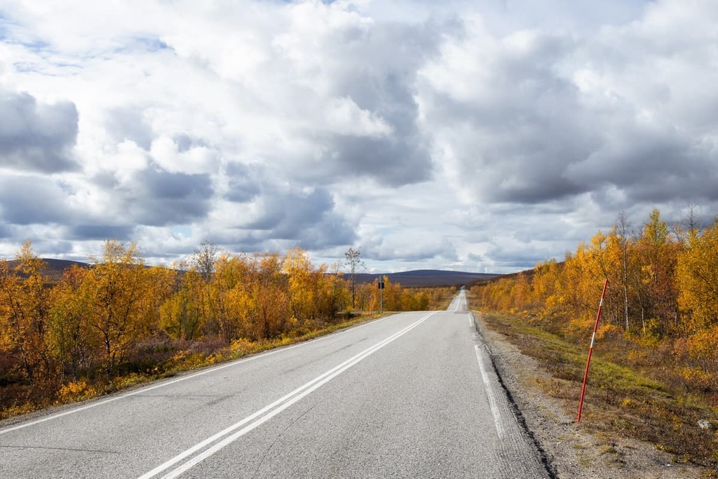
Both Kilpisjärvi and Enontekiö can be reached from Rovaniemi, the capital city of Lapland, by car. It is a 424 km (263 mi), 5 hour journey from Kilpisjärvi and a 305 km (189 mi), 3 hours 30 minute journey from Enontekiö.
The city of Rovaniemi, in turn, can be reached by bus or train from Helsinki, or by plane, if you are going to travel by public transport. I recommend the land route if only for the sake of telling your friends afterward, "On the way to Lapland I drove (not flew) all over Finland by land and saw all its beauty."
The border between Finland, Norway, and Sweden can be easily crossed, but check if you need a visa or any other special travel documents before your trip.
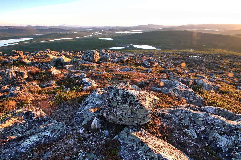
When backpacking in the Käsivarsi Wilderness Area, you can see many types of rocks such as granites, gneisses, shales, quartzites, and others that are common throughout the Scandinavian Peninsula.
Indeed, the wilderness is located on a segment of the Earth’s crust called the Baltic Shield, which is 1.5 to 3 billion years old, or 2.7 billion years old on average. Therefore, the rocks in this region are among the oldest in Europe.
But if we talk about the Scandinavian Mountains, in particular, to which the highest peaks of the Käsivarsi Wilderness Area belong, we need to note that these peaks formed 400 million years ago during the Devonian and Ordovician periods, which means that they are relatively young.
During this time, a major mountain-building event called the Caledonian orogeny helped to create these wonderful mountains, which occupy a tiny part of Finland compared to four other geological events or layers in the country: the Kola Domain, Karelian Domain (covers the major part of the Käsivarsi Wilderness Area), and Svecofennian orogen.
Later, during the Pleistocene geological period, much of these mountains were covered by ice. This glacial maximum helped to carve out many of the topographical features that we see in Norway, Sweden, and the northwest of Finland today.

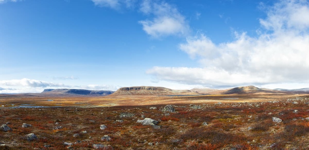
Käsivarsi Wilderness Area has three main landscape features: the Fell Lapland, a number of large valleys, and an abundance of bodies of water.
As part of northern Lapland, the wilderness belongs to the so-called Fell Lapland natural subregion. Here, the dominant features of the landscape are chains of low mountains (called fells) that average 500 to 800 meters (1,640 to 2,624 ft) in elevation. At the same time, this natural area differs from the others by the presence of higher Scandinavian Mountains. The rest of Lapland is a flatter area called Forest Lapland.
The second main feature of Käsivarsi are the valleys between the mountains that are home to many different Arctic plants. This makes them an ideal place for reindeer husbandry, which has been practiced here for centuries by the Sami people.
The third feature in the wilderness is water and the many forms that it takes. This includes:
The wilderness area is located in a climatic zone that’s unique to Finland, where northern latitudes meet high elevations. As a result, the local flora is characterized by a very short flowering period of only 100 days a year between the end of June and the end of September. However, it is quite biodiverse because of the influence of the Gulf Stream from Norway.
Most of the area of the Fell Lapland is located above the treeline, which is situated around 900 m (2,952 ft) in elevation. Here, the primary plant species include glacier buttercup, hairy housewort, Arctic bellflower, snowy cinquefoil. Some of the plants here are even considered to be rare by local Finnish scientists, such as alpine fleabane, woolly pussytoes, Lapland rosebay, and Arctic bell-heather.
As far as trees go, there are birch trees in the area but not many, and you can find them only in the river valleys and not on the fells' tops.
The main feature of the fauna of the wilderness, which is depicted on its official logo, is the ptarmigan (Lagopus muta). The ptarmigan is a particularly common bird that you can easily see because they live in this wild area and other parts of Lapland all year round.
These birds feed on plant buds, seeds, and berries. If you walk in the forest during the winter, don't be afraid if these birds jump out at you from the snowdrifts. They spend in snow drifts to rest during the day and sleep during the night.
The fauna of this wilderness area also includes other regionally common animals like lemmings, root voles, least weasels, stouts, Arctic foxes, lynxes, wolverines and, of course reindeer—the king of all northern animals. Sometimes you can see bears and wolves, but they are rare compared to the other local wildlife.
There are about 89 species of birds in the wilderness area, too, including peregrine falcons, snowy owls, lesser white-fronted geese, gyrfalcons, and Siberian tits, among others.
The area's rivers and lakes are full of different fish, of which salmon is considered the most common. Fishermen from all over the world come to Finland for the best fishing of their lives.
The mountains in Käsivarsi are distributed more or less evenly throughout its territory, but the highest peaks are located in the northern part of the wilderness. This includes all 23 Finnish peaks over 1,000 meters (3,281 ft) high, starting with Halti and ending with Meekonvaara peak at 1,020 meters (3,346 ft).

These mountains are the southernmost part of the Scandinavian Mountains, most of which are located in Norway. The highest mountain of these mountains, Galdhøpiggen (2,469 m / 8,100 ft) exceeds the height of Halti by more than 1,000 meters (3,280 ft).
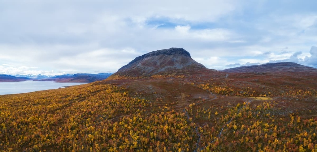
If you’re looking for the highest peak of Finland, try not to be confused. Halti has three other names: Haltiatunturi in Finnish and Háldičohkka in Sámi, and Halde fjäll in Swedish. Fjäll or fjell is tunturi in Finnish, which means hills above the timberline. That’s why you can see this same ending in the names of many mountains here.
It is located in the very north of the wilderness on the border with Norway. You may already know from the PeakVisor guides to Lapland and Finland that this peak refers to a higher peak called Ráisduottarháldi (1,361 m / 4,465 ft), which is located in Norway.
In general, both the peaks and the surrounding mountains of the Háldi region are characterized by wilderness. There are no roads here and the main residents of the region are reindeer herders.
Halti is also known for the fact that its name is often used to name many other places in Finland or companies. For example, there is nature center Haltia in Nuuksio National Park within the Uusimaa region, and the main outdoor clothing and equipment brand in Finland also called Halti.
When in the wilderness, you also can’t miss the second highest mountain in Finland: is Ridnitšohkka (1,317 m / 4,320 ft). It is also the highest peak located entirely on its territory. Climbing to this peak you can also see Halti, the neighboring Ritninolka (1,186 m / 3,891 ft), and many other peaks.
The more southerly mountains in the Käsivarsi area and all the other hills in Lapland belong to the more ancient Karelides Mountains.
These peaks are about 2 to 3 billion years old. However, before being eroded over millions of years, these peaks once exceeded the height of the Alps, reaching 5,000 m (16,404 ft) above sea level. You can find these same peaks in the North Karelia and Kuusamo regions of Finland.
Trips to Käsivarsi and other wilderness areas in Finland involve hiking on unmarked trails (that is, without trails), where you need solid orientation skills and persistence to overcome more difficulties than in a normal hike in a national park or nature reserve with marked trails.
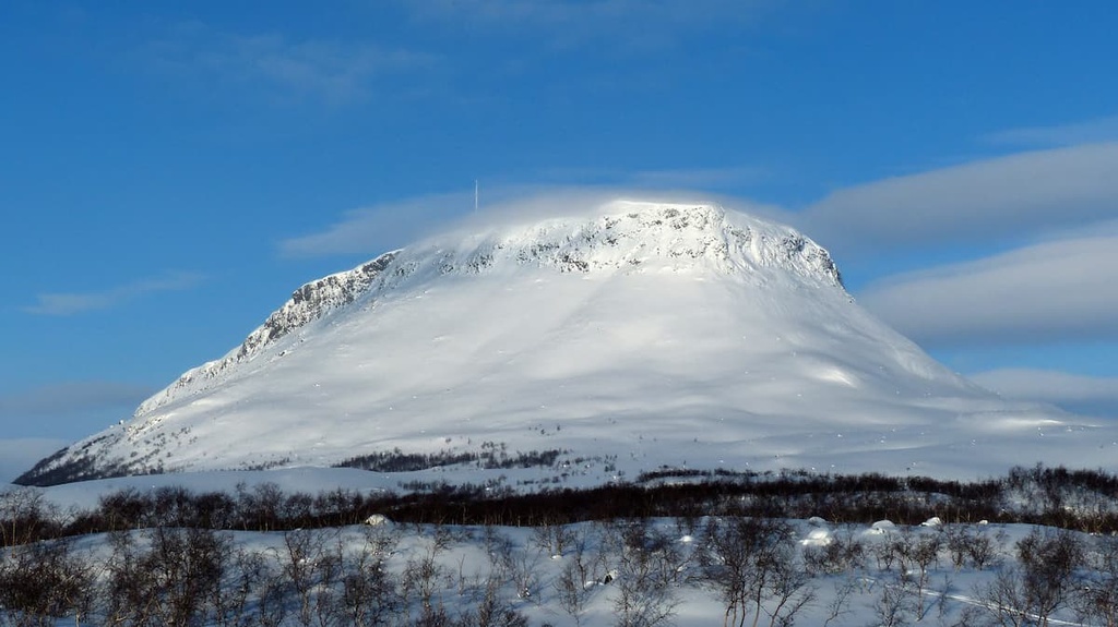
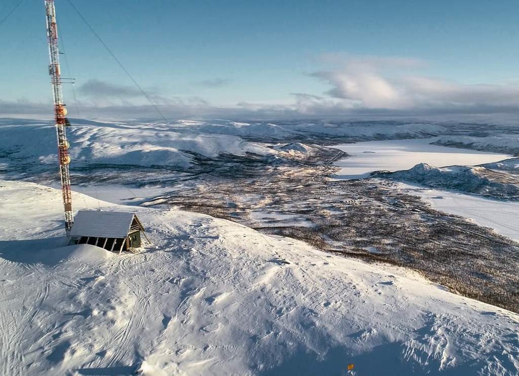
Also, keep in mind that the weather conditions are very harsh here both in summer and in winter. The average summer temperature is 10 to 15 degrees Celsius (50 to 60 degrees Fahrenheit).
You should be prepared both physically and mentally for the trip, and you should have all the necessary gear and equipment for navigation and communication. This includes, of course, an assortment of food for the duration of your trip as people usually come here for at least a week.
However, despite the relative lack of trails in the region, the Käsivarsi Wilderness Area does have three marked and very popular trails. These include:
The Iitto Nature Trail is a small nature trail near the village of Iitto, which is situated about 50 km (31 mi) to the south of the village of Kilpisjärvi on the Swedish border. On the trail, you can learn about the local flora and fauna and test your skills before heading out on a longer hike. In particular, the trail winds through Iitto Mire Reserve and its many palsa bogs, which are a type of bog with frost mounds.

This is the main route in the wilderness area to Finland's highest peak, Halti, from the village of Kilpisjärvi. The trail is 55 km (34.1 mi) long one way, which means that you will have to walk a minimum of 110 km (68.3 mi) if you stay on the trail.
Along the way, you will see all the main natural attractions of the wilderness area, including many lakes, rivers, valleys and gorges. At the end of the route, from the peak of Halti, you will see many other famous peaks, such as Ritničohkka (1,317 m / 4,320 ft), Gieddečohkka (1,285 m / 4,215 ft), Etu-Halti (1,201 m / 3,940 ft), and others. But the main value of the trail is of course its wild untouched nature, as well as the emptiness and silence of the wilderness.
The trail crosses the border to Norway several times at the beginning, then you go on Finnish territory until you arrive at the border with Norway again. Keep in mind that at Pitsusjärvi Lake, the trail divides into two routes: the rightmost path leads to Somasjärvi Lake and Norway while the leftmost path goes to Halti Fell.
The starting elevation of the trail is 500 m (1,640 ft) and the ending elevation at the top of Halti is 1,324 m (4,343 ft). With an elevation change of 824 meters (2,703 ft), you will gain 550 m (1,804 ft) on the climb to Pitsusköngäs Falls. From here, you’ll climb the remaining 324 m (1,062 ft) to reach the summit.
In addition to the hiking trail to Halti from Finland, you can also climb it from Norway from the village of Birtavarre. This trail is about 6 km (3.7 mi) long.
This route is also a part of the long and very famous Nordkalott Trail. More than 3,000 people take this route every year.

The Nordkalott Trail, or Arctic Trail, is a multi-day hiking and backpacking trail that’s some 800 km (497 mi) long. It travels through the northern parts of Norway, Sweden, and Finland.
It is the longest northern trail in Scandinavia and one of the northernmost long distance trails in the world. It is also part of the European long-distance hiking route E1, which travels some 7,000 km (4,300 mi) from Nordkapp in Norway to Sicily in Italy.
There are three starting points of Nordkalott:
The Norwegian and Swedish parts of the trail are 380 km (mi) and 350 km (mi) long, respectively. The Finnish part is “just” 70 km (43.4 mi) and can be completed in 6 to 7 days.
The portion of this trek that ventures through Finland is a difficult route, for which you need to be prepared physically and mentally.
For example, it crosses two of the largest rivers in Finland on the way, Bierfejohka and Vuomakasjoki. During the hike, you normally cross these rivers using bridges but on July 1, 2021, the flood destroyed the Vuomakasjoki Bridge.
The new bridge will be built in 2022, but there is always a chance of another flood that will force you to cross the river without the help of a bridge. There are also many smaller river crossings during the hike.
In addition to hiking and backpacking, the Käsivarsi Wilderness Area has opportunities for many other summer sports and outdoor activities.
This includes mountain biking, fishing, geocaching, dog sledding, snowmobiling, bird watching, berry and mushroom picking, canoeing (Poroeno–Lätäseno route is 100 km / 62.1 mi), guided trips and safaris, and swimming.
There are no marked routes for cross-country skiing in the Käsivarsi Wilderness Area, but you can use the snowmobile routes that start in the village of Hetta.
You can reach Halti, following the Victoria Route along the Swedish border from Muonio to Kilpisjärvi, or travel between the Palojärvi and Kilpisjärvi lakes.
There are three visitor centers in the viсinity of the Käsivarsi Wilderness Area, including Halti National Park Center in Storslett—a visitor center of Reisa National Park in Norway from where you could enter Käsivarsi Wilderness Area.
There, you can get more information about hiking and other activities in the area, get advice from the locals and buy some useful souvenirs, like maps and books about the area. For example, in the wilderness, you could use puukko—a small traditional Finnish belt knife.
Kilpisjärvi Visitor Center
Käsivarrentie, 14145, 99490, Kilpisjärvi (Enontekiö), Lapland, Finland
Hours from March 3 to May 2: Mon to Sun, 10 am to 5pm
Hours from June 7 to October 3: Mon to Sun, 10 am to 5 pm.
Closed on August 14–15
+358206397990
Fell Lapland Visitor Centre
Peuratie, 15, 99400, Enontekiö, Lapland, Finland
Open all year round with different schedules
Hours from May 31 to October: Mon to Sun, 9 am to 5 pm
+358206397950
Halti National Park Center
Hovedveien, 2, 9152, Storslett, Noway
Open all year round
+4777588250
Read about particular rules and regulations in the wilderness area on the official Finnish National Parks website.
Note that the emergency phone number in Finland is 112. However, when hiking in the wilderness, try to keep your phone warm and bring a power bank because this is a place with cold temperatures, even in the summer. There are many locations with no mobile coverage in the area, too. Always let someone know about your itinerary and timetable before heading outside.
There are 22 open wilderness huts in the Kilpisjärvi village area and the Käsivarsi Wilderness Area, where you can spend the night in a shared room without the need for an advanced reservation.
Another option is reservable wilderness huts. There are seven of them in the area. They are the same as open huts, but you can book a place in a hut in advance to be sure you have accommodation for the night—like in the rifugios in the Dolomites.
Note that all huts in the Käsivarsi have a gas stove for cooking, though other amenities can vary from hut to hut.
In the wilderness area, there are also four rental huts—a type of hut you can rent for you or a group of people to share without other visitors. Prices vary, but the Jogasjärvi Rental Hut costs €120 per day or €720 per week. It is available for rent all year round.
There are two campfire sites at the southern end of Saanajärvi Lake near the Kilpisjärvi village. You can also cook food and pitch your tent everywhere in the wilderness except on the marked trails.
Just remember that lighting a campfire is permitted, but not recommended by the National Parks of Finland. Anyway, there are very few fallen branches you can legally take as firewood in Lapland. Lighting campfires is always forbidden when there is a forest fire warning, which happens each year during the hottest months of July and August.
In the village of Kilpisjärvi, you can find several hotels and other types of accommodation options, including: Santa's Chalets Rakka, Guesthouse Haltinmaa, Saivaara Cottages, Lapland Hotel Kilpis, and Tundrea Holiday Resort and Restaurant.
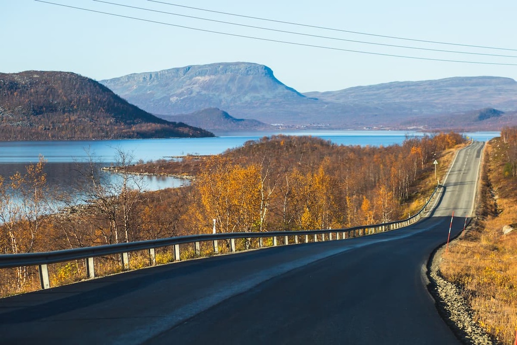
Kilpisjärvi is the main settlement in the region. It is located on a picturesque peninsula on Kilpisjärvi Lake, about 20 km (mi) from the western border of the Käsivarsi Wilderness Area. It belongs to the municipality of Enontekiö.
Enontekiö is one of the 20 major municipalities of Lapland. It covers an area of 8,400 sq km (3,200 sq mi) that spans the entire northwestern "arm" of Finland.
The administrative center of Enontekiö is Hetta village, which is also synonymous with the municipality or its second name. In addition to Hetta, the municipality includes more than 20 towns and villages, the largest of which are Karesuvanto, Kelottijärvi, Palojoensuu, Vuontisjärviu.
The city was founded in 1877. Today it has 1,818 residents (2021). Just like in Kilpisjärvi, many Sami people or Lapps live here, raising reindeer and welcoming travelers from other parts of Finland and around the world.
The five main architectural and cultural attractions of Hetta and the region:

Check out the official tourist website of Enontekiö and Kilpisjärvi: Lapland.fi.


