
Scan the QR code and open PeakVisor on your phone
Uusimaa is home to 309 named mountains. The highest is Loukkumäki at 174 m.
Uusimaa is the capital region of Finland. It is located in the southern part of the country and its main features is Helsinki—one the most environmentally-friendly cities in Europe. Other major features include Nuuksio National Park and some 230 km (143 mi) of rocky Baltic Sea coastline. There are 309 named peaks in Uusimaa, the highest of which is Loukkumäki (174 m / 570 ft) and the most prominent of which is Lintukiimanvuori (157 m / 515 ft).
Uusimaa is one of the 20 regions of Finland. It is located in the southern part of the country on the shores of the Gulf of Finland on the Baltic Sea.
The region consists of three main parts: East Uusimaa, Middle Uusimaa, and West Uusimaa. Alternatively, it could be divided up into the four subregions of Helsinki, Raseborg, Loviisa and Porvoo.
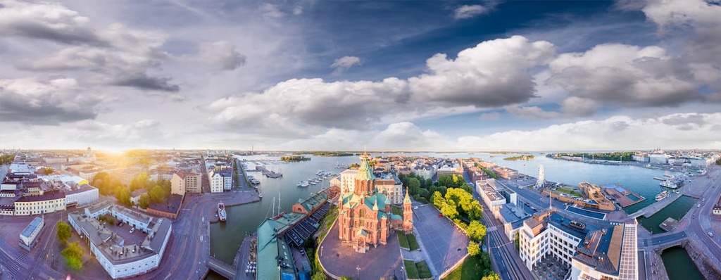
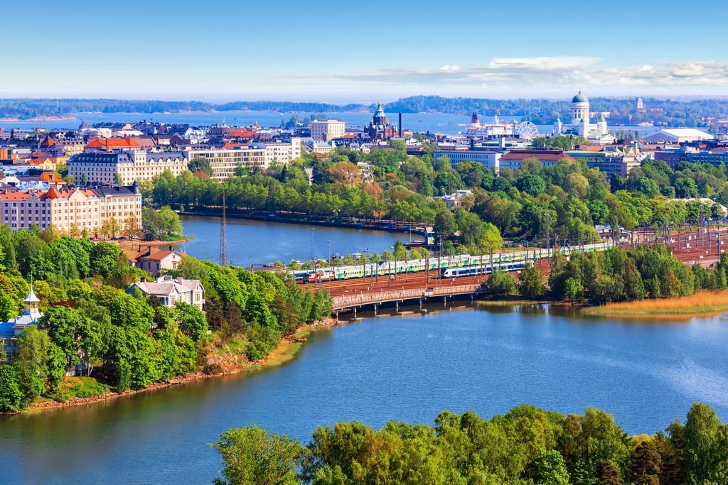
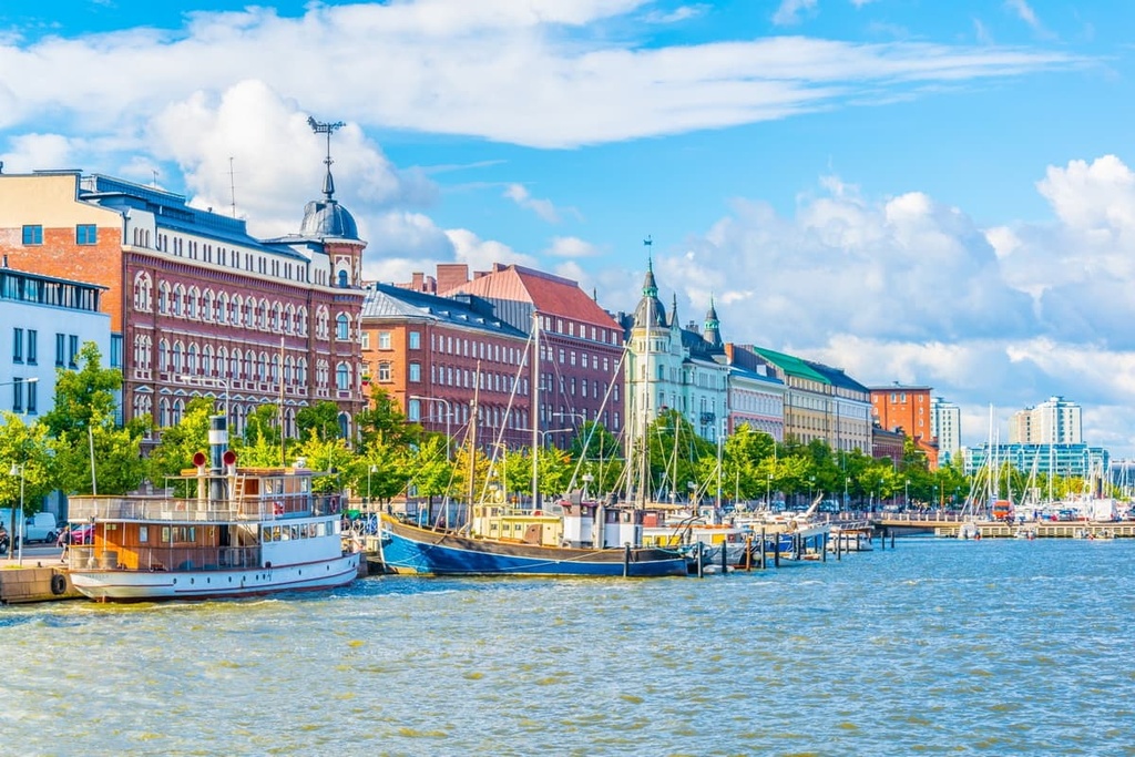
The core of Uusimaa is Helsinki, the capital and largest city of Finland. Helsinki, together with major suburbs of Espoo and Vantaa, form the Greater Helsinki metropolitan area.
This area is also one of the four major tourist regions of the country, along with the Archipelago Sea to the west of the city of Turku, the Lake District (including North Karelia and South Karelia), and Lapland.
In other words, despite the relatively small size of Uusimaa (9,568 sq km / 3,694 sq mi or 3% of Finland's land area), it gets the bulk of the country’s tourism.
The region borders four other regions: Southwest Finland, Tavastia Proper (Kanta-Häme), Päijänne Tavastia (Päijät-Häme), and Kymenlaakso.

During my many travels to Finland, I’ve noticed that Helsinki is a unique city that can be reached by pretty much any means of transportation. For example, you can fly to Helsinki-Vantaa Airport, drive, take the train, bike here from St. Petersburg in Russia, or even take a ferry from Stockholm, Sweden, or Tallinn, Estonia.
Take your time in the airport after your arrival, or plan to spend more time in it before you leave the country. In the airport, there is a hall with an interesting installation—a screen upon which images of different natural places in Finland during different seasons are projected. Meanwhile, the corresponding sounds of nature are played in the background.
The information boards in the exhibit give you more information about each of these images. For example, you might find yourself in Koli National Park in North Karelia.
The Helsinki-Vantaa Airport is also oddly quiet for something that serves as the country’s main transportation hub. In fact, almost nothing is announced on the loudspeaker as the airlines will call you to board the aircraft just once.
Geologically, the territory of the Uusimaa region is mostly homogeneous. It dates back to the Svecofennian orogeny, which lasted from about 2 to 1.8 billion years ago during the Paleoproterozoic era.
The rock layers in the region are also among the oldest in Europe. In particular, the layer is one of the five main parts or, as geologists say, “provinces” of the Baltic Shield, an even older segment of the Earth's crust on which the whole of Scandinavia is also located.
Just how old is this rock, you might ask? This layer is 1.5 to 3 billion years old. The thickness of this geological strata here—250–300 km (155–186 mi)—is just as impressive.
The Baltic Shield has been rising steadily throughout history. So, in the region of Uusimaa, Finland and Scandinavia we see many examples of different rocks coming to the surface.
The main rock types in the region are granites, gneisses, shales, and quartzites, which you can see while walking and hiking along the coastline or in the forests. The many huge boulders that you’ll see may also seem to you like something scattered them on purpose. In fact, these boulders were left behind by the glaciers that once covered all of northern Europe.
In the Uusimaa region, we can also find a few geological anomalies. For example, there are many limestone deposits near the town of Lohja. As a result, the region has been mined for centuries. Around Lohjanjärvi Lake, you can even see many limestone rocks, which are rare in the region.

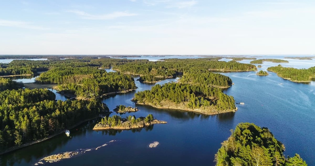
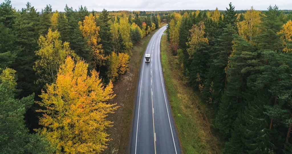
One of the things that makes Uusimaa so unique is that the region is home to nearly all the natural landscapes of the country, except the mountain tundra and fell areas of Lapland. This includes the coastline, dense pine and spruce forests, lakes, and the farmlands for which the Häme region is famous.
But, in my opinion, water is the main feature of Uusimaa’s landscape. The total length of the coastline of the region is about 230 km / 142 mi (103 km / 64 mi in Helsinki), while the whole of Finland contains some 1100 km (683 mi) of coastline.
The entire southern coast of the region is very rugged, so there are many picturesque skerries (groups of islands and rocks). There are also many bays that extend deep inland, such as Espoonlahti and Pohjanpitäjänlahti. So this is no less impressive territory than the neighboring Archipelago Sea in the southwest in the Gulf of Bothnia.
The largest lake of the region is Lake Lohjanjärvi (Lake Lohja), which is located near the town of Lohja some 83 km (51 mi) to the northwest of Helsinki. If you want to visit the Finnish lake and go hiking around it, it’s a great place to go for a day trip or even a couple of days. There are usually marked trails around all the major lakes in the country.

Finally, I should point out that in the Uusimaa you can visit 5 of the 27 places on Finland’s list of national landscapes. This list was compiled in 1992 to commemorate the country’s 75th anniversary of independence. Here are these 5 places:
The Uusimaa region is the most populated region in Finland, with more than 1.7 million residents (2020), or roughly 30% of the country’s population. By comparison, the same number of people live in neighboring St. Petersburg. Here is a brief history of the region:
The very earliest archaeological findings in the region date to the Iron Age to around 1100 BCE. These findings suggest that this area was originally inhabited by tribes that today inhabit the North Karelia, South Karelia, Savonia and Häme regions in the east of the country, as well as Southwest Finland, where the first Finnish capital, the city of Turku, is located.
Therefore, most of the present population of the region are descendants of these people, who are commonly referred to as the Finns. However, these areas were ruled by Swedes and Russians until 1917 until Finland finally gained its independence. In 2017, the country celebrated its 100th anniversary in a big way.
The name of the present region of Uusimaa in Swedish, Nyland, first appears in historical sources in 1326. The capital of the region and the whole country, Helsinki is also a Swedish city that was founded in 1550 by King Gustav I of Sweden. The city became the capital of Finland in 1812 when the region was part of the Russian Empire.
The geographical location of Finland between Sweden and Russia has left many sad marks on Finnish history, including many small and large wars.
This is especially noticeable here in the metropolitan region of Uusimaa. Here, along the coastline from Porvoo to Hanko we can find many fortresses on islands and various defensive and military structures.
Most of these structures were built by the Swedes or Russians to defend and attack each other. They were then used by the Finns for the same purposes in their struggle against Russia during World War II.However, the armed conflict between Sweden, Finland, and Russia has ceased in recent decades.
In fact, Swedish is considered the second official language in Finland. You can see it everywhere in the names of the streets, road signs and so on. Many Finns also speak Russian well and learn the language at school in order to communicate better with their neighbors.
Although Uusimaa is a historic region in Finland, the new Uusimaa region was formed relatively recently in 1997. Its borders have been changed a number of times in recent years, most recently inl 2011.
Once you are in the Uusimaa region, you will see for yourself that it has mostly flat terrain. However, there are hundreds of low hills of up to 200 m (656 ft) in the region and thousands of beautiful cliffs and rocks right in the city of Helsinki. This is particularly true along the entire coastline, on the lakeshores, and in the forests.
Nevertheless, there are a handful of mountains in the region that you can climb up in order to admire the sprawling seascapes and pine forests. Of course, the higher you climb, the farther you see, but in my experience of hiking in the region, climbing even 200–300 m (656–984 ft) is often enough to see the spectacular views of southern Finland.
The highest peaks of Uusimaa are located in the north and northwest of the region, but you can start exploring the mountains of Finland right in Helsinki. Here are the eight highest and most interesting mountains to check out in the region:

Mäntymäki is a small hill in the city center with a nice view on Töölö Bay (Töölönlahti). It is a large body of water in the heart of Helsinki that is connected to the Baltic Sea. So, it is an inland bay rather than a lake. You can also go for a walk around it, which I highly recommend doing.
The further you move to the north of the center of Helsinki, the more hills and granite cliffs you can find and the higher they get.
Ullanlinnanmäki is the highest hill in the city center of Helsinki. It is located at the southern tip of the center in Kaivopuisto Park. From the top of the hill, you can enjoy a stunning view of the skerries of the Gulf of Helsinki.
There is also a building with a domed roof that’s part of the Ursa Astronomical Association Observatory (Kaivopuiston tähtitorni) on the hill. Ullanlinnanmäki is also a great place for a mid-day picnic.
Taivaskallio is a famous peak in the Käpylä district in the north of the region. From it, you can see the city center and the tower of the main railway station of Helsinki. On the hill, there are also the remains of the heavy anti-aircraft battery, which was used during the Winter War with Russia in 1939–40.
Paloheinän huippu is the highest peak in Helsinki Central Park. The park itself is also a great place to go to if you want to hike all day long.
Malminkartanonhuippu is the highest peak in the city of Helsinki with an elevation of almost 100 m (328 ft). It is located in the Malminkartano district in the northwest of the city center.
There is an interesting arrow leading to the top of the hill, as well as 426 steps. Now it is the recreational area for mountain biking and sledding in the winter.
Mustakorvenkallio is the highest mountain in the Nuuksio National Park—the most popular hiking area in Uusimaa. It is located in the eastern part of the park near Saarijarvi Lake.
Lintukiimanvuori is one of the highest and most famous peaks in the region. It is located 32.4 km (20.1 mi) to the north of the town of Lohja.
There is a road right above the peak, so the mountain could be easily reached by car—or better yet, a mountain bike—from town. The top of the mountain is open, too, so it is a magnificent viewing platform from which you can see the endless pine forests of the region.
Not far from the summit, there is also the Church of the Shepherds (Paimentenkirkko)—one of many so-called "Finnish Forest Churches.” This very minimalistic church has no building. It consists of only a wooden cross and a few wooden benches set right on the hill next to a huge rock with a cleft inside.
“According to the old story, shepherds gathered into the cave during the rain and at the same time they had divine services,” says local Harri Kuusinen when describing the church in a drone video on his YouTube channel.
Loukkumäki is the highest peak of the entire Uusimaa region. It is located some 7.2 km (4.4 mi ) to the northwest of the town of Karkkila.
This mountain can also be reached by car or bike as there is a road nearby. At the top, you will find an abandoned observation tower from which you can also see endless pine forests and three small lakes.
While in Uusimaa, you are likely to find a marked hiking trail right outside your accommodation that will lead you to the forest, a lake, or one of the region’s low-lying peaks. Of course, this isn’t always the case, but there is a great deal of truth in this saying.
In Uusimaa you will find more areas for walking, hiking, and other outdoor activities than city streets. Finns themselves like to joke about this, too. In fact, they often say that they live in forests rather than cities.
Here’s an overview of the main hiking areas, long hiking trails, and points of interest in the region:
There are three main areas for walking and hiking in the region: the city of Helsinki itself, national parks, and other nature areas:
Helsinki
Central Park (Keskuspuisto) of Helsinki is not like the Central Park in New York. This is a real forest in the heart of the city that stretches from north to south for almost 10 km (6.2 mi) from the Laakso area to the Haltiala area and to the Vantaanjoki River. The entire park is walkable. It also has three short themed trails:
In addition, there are more than 30 other hiking and recreational areas in Helsinki and suburbs. One of the most popular, Uutela Nature Park, located in the easter part of the city in the Vuosaari district on the Kallahdenniemi Peninsula.
National Parks & Other Nature Sites
There are five parks in the Uusimaa region:
In addition to the five national parks, there are a number of other nature sites in the region. For example, there is Karkali Strict Nature Reserve—one of the finest herb-rich forests in Finland. It is located at the end of a small peninsula in the Lohjanjärvi Lake near the city of Lohja.
Most of the region’s main long hiking trails are located within the five national parks and recreation areas. You can hike most of them for anywhere from two days to a week:

Additionally, there is the King’s Road, a historically important Middle Age mailroad from Bergen, Norway, to Vyborg, Russia via Oslo, Stockholm, Åland Islands, Turku, and Helsinki.
On the route, you can see a lot of old manor houses, castles and forts, churches, bridges, and other similar constructions in the small old Finnish towns. The distance of Finnish part of the route from Turku to Vaalimaa on the border with Russia is about 400 km (250 mi). You can walk it, of course, but riding it on a bike only takes about 3–5 days.
In addition to the national parks, there are many other interesting places in the region, from the remarkable wooden buildings in the center of Helsinki to the lighthouses on an Baltic islands, which can only be reached by sea. Here are some of the highlights:
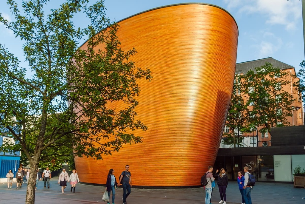
Important and Historic Wooden Buildings
Historical and Nature Districts
Islands, Fortifications, and Seascapes

Nature Centers and Museums
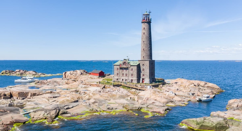
Lighthouses
Vihti Ski Center is the largest of 13 ski resorts in the Uusimaa region. It is located about 48.5 km (30.1 mi) to the northwest of Helsinki.
The resort has 3.8 km (2.3 mi) of slopes for both alpine skiing and snowboarding, including:
There are also 9 ski lifts at the resort. The vertical difference at the resort is 70 m (229 ft) between the resort’s lowest elevation of 50 m (164 ft) and its highest elevation of 120 m (229 ft). A ski pass at the resort costs about €34 for the whole day.
When you arrive in Finland, be sure to visit the official Tourist Information Point located in the main railway station in the city center of Helsinki:
Helsinki Tourist Information
Kaivokatu 1, 00100 Helsinki, Finland
Daily from 9 am to 4 pm
+0931013300
In case of emergency, 112 is the single emergency phone number for ambulance, fire, and police calls in Finland.
In Helsinki and the Uusimaa region, you can easily find all kinds of accommodation options, including the famous Finnish cottages with saunas in the countryside. These are common to rent during summer vacations, even among locals.
Good places to check out include the Eurohostel in the Katajanokka Harbor area in the center of Helsinki. The hostel itself is nice enough, but the real attraction to the area is that it’s located in an authentic Helsinki neighborhood, which will help you feel more like a local. A room for two people costs about €50.
If you like nature more than the urban environment and are going to stay in the city longer than a couple of days, you might want to check out the Käpylä and Olympiakylä neighborhoods, which are located next to a large park. These areas were built as Olympic villages for athletes for the Summer Olympics in Helsinki in 1952. They are very quiet and nice areas to live in.
When hiking in the national parks of Uusimaa, you can rent a cabin for about €50–80 per night. Make a reservation at Verkkokauppa.eraluvat.fi by going to the Huts section.
Wild camping is also a popular option in this part of Finland. Just remember that you can pitch a tent and make a campfire only in specially designated places in the national parks and other areas.
For example, in Teijo National Park there are three rental cabins for six people each and 13 campfire sites. In the summer you can also sleep in seven lean-to shelters in the park.
The Uusimaa region consists of 26 municipalities with 13 cities, which in addition to Helsinki, Espoo, and Vantaa, include Järvenpää, Sipoo, and other towns. Besides these major cities, here are some of the best places to visit during a day trip from Helsinki.
Raasepori / Raseborg is the main town and municipality in the area of Ekenas Archipelago in the southwestern part of the region. It consists of several small towns: Ekenäs, Karis, Pojo, Fiskars, Billnäs, Snappertuna and Tenala. The town is home to about 27,000 people.
The main attraction of Raasepori is the Raseborg Castle, which was the main administrative center of Finland (then part of Sweden) in this part of the country during the Middle Ages. The region is also known as a place of iron mining. It’s also famous for the production of various products such those made by the brand Fiskars.
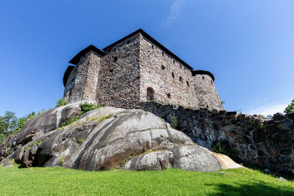
Be sure to check out the official tourist site of Raasepori: Visitraseborg.com.
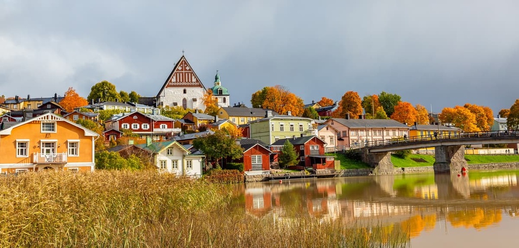
Porvoo / Borgå is a small, idyllic town and municipality to the east of Helsinki. As such, it is a popular day-trip destination from the capital of Finland. It has a total population of about 50,000 people.
The main attraction of Porvoo is the Old Town, with its many well-preserved buildings from the eighteenth and nineteenth centuries. The city is also considered one of the five Medieval cities in the country, along with Turku and others, and one of the most beautiful small towns.
Porvoo city has a special beauty thanks to the Porvoonjoki River Valley. It also features a series of old wooden warehouses colored in traditional Scandinavian red ochre that are located along the river.
The official tourist site of Porvoo: VisitPorvoo.fi.


Yes. Uusimaa has 309 named mountains. The highest is Loukkumäki at 174 m.
The highest mountain in Uusimaa is Loukkumäki, at 174 m.
Uusimaa has 309 named mountains.


