
Scan the QR code and open PeakVisor on your phone
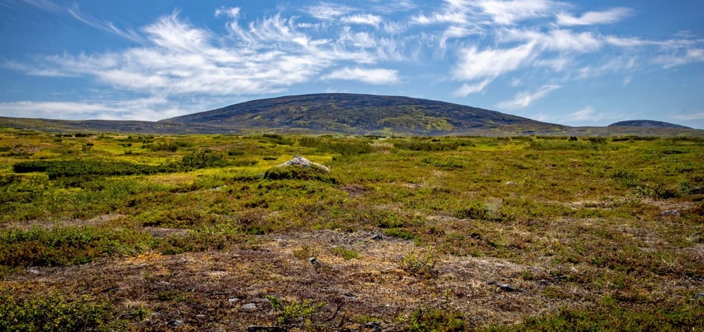
Pöyrisjärvi Wilderness Area is one of Finland's 12 wilderness areas, all of which are located in the Lapland region in the north of the country. The main feature of the wilderness area is its namesake lake and the large Sámi reindeer herding village that’s located nearby. Pöyrisjärvi is also one of the most mountainous wilderness areas in the country as it contains 52 named peaks, the highest and most prominent of which is Termisvaara (612 m / 2,007 ft).
Pöyrisjärvi Wilderness Area (Pöyrisjärven erämaa-alue) gets its name from the nearby lake, Pöyrisjärvi, which is located just 1.7 km (mi) from the border with Norway.
The first part of the word Pöyrisjärvi is definitely of Sámi origin, as are the names of other lakes, mountains, swamps, and other natural landmarks in the region. Its meaning, however, is unknown.
The second part of the word is easy to guess, it means simply “lake” in Finnish. As such, you’ll see järvi in the names of most of the other lakes in the country.
With regards to the phrase “wilderness area,” in general, in Finland, wilderness areas are regions of the untamed wilderness without human development. Here, you can wander for weeks and literally meet no other people.
You can read more about the meaning of wilderness areas in Finland in the guide to Paistunturi, which is the most mountainous of the country’s wildernesses.
The total area of Pöyrisjärvi Wilderness is 1,280 sq km (494 sq mi). It is located in northern Lapland, which is the largest of the 19 counties of Finland. Administratively it belongs to Enontekiö, the largest and the northwesternmost of Lapland's 21 municipalities.
The boundaries of Pöyrisjärvi are easiest to describe in relation to its neighboring parks and protected areas. In fact, if you go on a trip to Pöyrisjärvi, you enter a whole world of undeveloped territories, so, if you have time, you can visit the neighboring ones as well, which include:
Inside or near the Pöyrisjärvi itself, there are also several reserves that were set up to protect the unique nature of the vast Lapland bogs and fells. These include Pöyrisvuoma Mire Reserve and Saaravuoma-Kuoskisenvuoma Mire Reserve, both of which are located to the south of the area.
If you’re traveling by car, to get to Hetta, the municipal center of Enontekiö, you have to take road 79 from Rovaniemi, the capital of Lapland. This is the shortest and most direct route between two cities (305 km / 189.5 miles, 3 hours 45 minutes). The fastest way to get to Rovaniemi is by plane, train or car.
For those traveling by public transport, there are coaches from Matkahuolto, the main national Finnish bus company, that travel from Rovaniemi to Enontekiö.
The main starting point for excursions into the wilderness area is the village of Hetta itself and the Fell Lapland Visitor Center, which is the main visitor center in the northwestern part of the region. From there you can take the Hetta—Näkkälä Trail toward the wilderness area, which we will discuss later in this article.
Other good starting points for visits to Pöyrisjärvi are the villages of Näkkälä and Vuontisjärvi as well as Kalmakaltio on the north-side of the village of Nunnanen. The three latter villages are located to the east of Hetta, but they are no more than 40 km (24.8 mi) away.
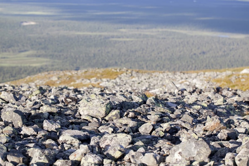
Geologically, the entire territory of the Scandinavian Peninsula, plus Finland, is located on the Baltic Shield (a segment of the Earth’s crust), which is 1.5 to 3 billion years old. The main rocks here are various kinds of granites, gneisses, shales, and quartzites, which are among the oldest in Europe.
Therefore, there are many granite rocks and huge boulders in the forests all over the country. In many instances, it seems like something scattered these boulders on purpose around the landscape. However, these boulders are actually traces of the glaciers that once covered all of northern Europe.
The geological features of Lapland also include the presence of gold, which used to be mined here just as it was in Alaska, USA. In particular, the neighboring Lemmenjoki National Park is known for this, where gold mines are preserved and you can try to mine gold yourself.
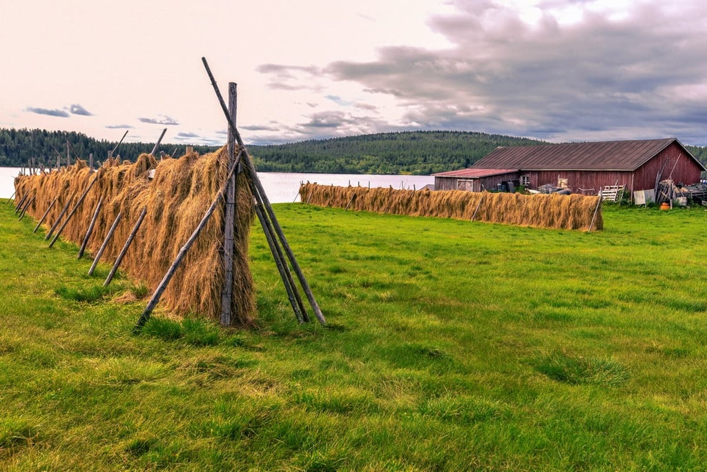
The most famous feature of the wilderness area is Pöyrisjärvi Lake. It is the largest lake in the wilderness and it is located in the northern part of the protected area.
It is 6.2 km (3.9 mi) long, 3.9 km (2.4 mi) wide, and it covers a total area of 15.05 sq km (5.81 sq mi) with a shoreline of 39 km (24 mi). The shores of the lake are mainly tundra, bare rock, or open marsh. The lake is located in the Kemijoki River basin, so it is connected to other lakes and you can canoe between them.
The lake is also home to 12 islands, the two largest of which are Isosaari (700 m / 0.4 mi long), and Kotasaari. The largest island is also inhabited—there is a summer cottage on it. There are three other cottages on the lake, but the area is mostly abandoned.
In total, there are 86 lakes and ponds in the Pöyrisjärvi Lake area. There are even more lakes in other parts of the wilderness area. The largest are:
The second major feature of the landscape is the two Sámi reindeer-herding villages that are located in the region.
One village is located not far from the Pöyrisjärvi Lake on the shore of a pond and bears the same name as the Pöyrisjärvi area. The other, Kalkujärvi, is located to the east on its namesake lake near the Norwegian border.
However, the Sámi do not live in these villages all year long. Rather, local reindeer herders use these villages only during the summer and winter. The winter-summer system is based on the annual migration required by nomadic reindeer husbandry. The village of Pöyrisjärvi is considered the largest of these traditional villages.
Other major landscape features in the area include:
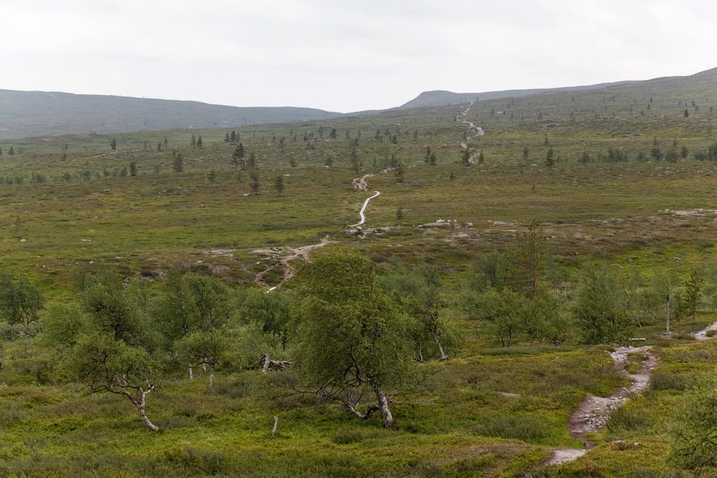
With respect to flora, as you move from the south to the north of the Pöyirsjärvi Wilderness Area, you’ll see that the pine forests give way to birch forests, which are the most common forests in the area. The hilltops in the region are usually treeless except for the occasional shrub, making each one a great lookout point.
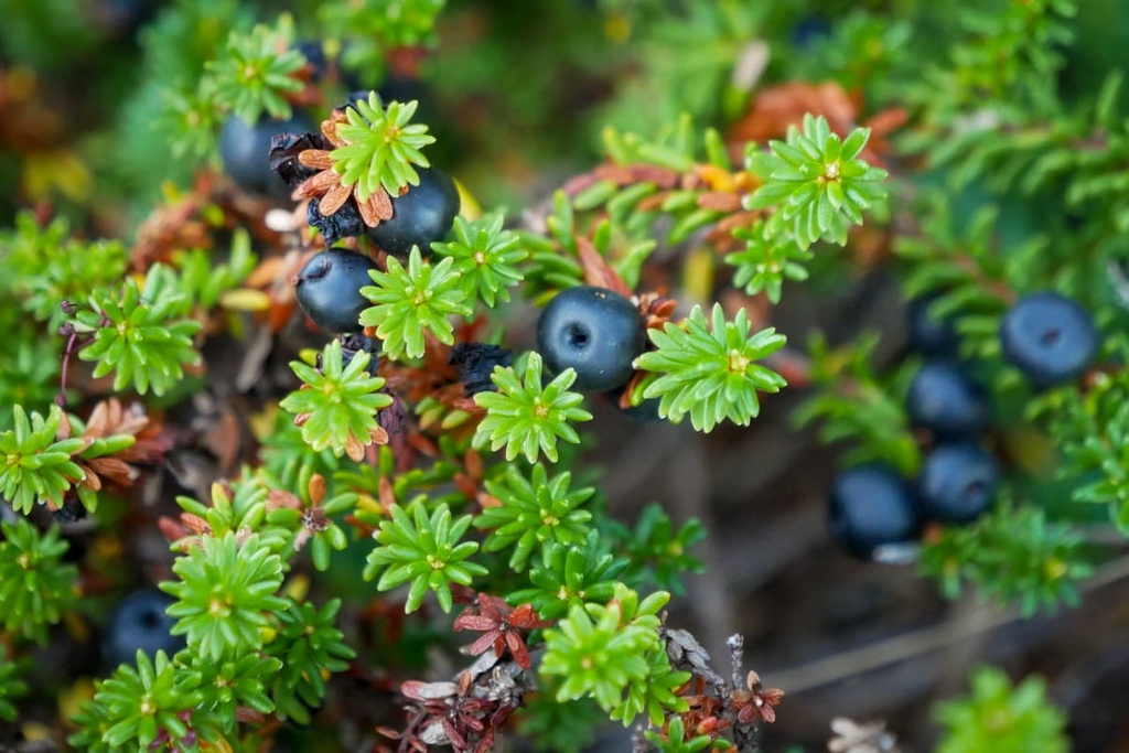
Of the low-growing plants in the wilderness, you can see such types as pillar-like juniper, black crowberry, lingonberry, bearberry, Alpine clubmoss, moss heather, Alpine azalea, Lapland diapensia, wood crane’s-bill, meadowsweet, melancholy thistle, and variegated horsetail, among others.
As far as fauna goes, the most common animal of the territory is the wader, a small bird with a beautiful blue breast. It lives in the swamps along with the ruff, common snipe, wood sandpiper, Eurasian golden plover, meadow pipit, and other bird species. Like everywhere else in the north, there are also many waterfowl ducks, geese, swans, and loons in the wilderness.
In Pöyrisjoki Lake, there are a lot of trout, grayling, and other fish species. Actually, every lake, pond or river here has many fish.
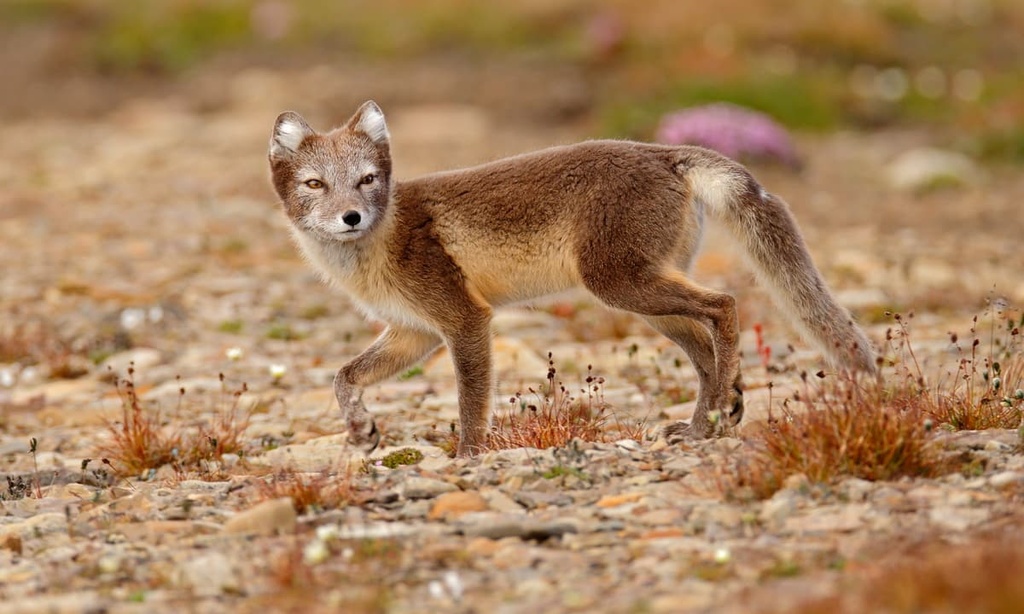
Among small predators and mammals, there are Arctic foxes (but a very, very few of them), lynx, wolverines, wolves, and bears, although they are not easy to spot in the wilderness.
The Finnish part of Lapland, except for the far northwest, is a vast area of land with small mountains, or hills, or fells, as they are commonly called, that are up to 1,000 m (3,280 ft) in elevation. Within the territory of Pöyrisjärvi, there are 52 such fells.
The fells are the remnants of very ancient mountains, the Karelides, that existed in Finland some 2 to 3 billion years ago. During this time, the range extended to the Finnish part of the Karelia region, which is now divided into North Karelia and South Karelia in the southeastern part of the country.
So what are these mountains? Nowadays they are not really the Karelides anymore. Today we see only their bases. But, imagine what they looked like when they reached the height of the Alps, where the highest mountain is Mont Blanc (4,807 m / 15,774 ft).
The highest and the most prominent peak of the Karelides in Pöyrisjärvi is Termisvaara (612 m / 2,008 ft). The "vaara" you see at the end of the word is a typical ending for mountain names in Finland, as it means “mountain.” It is also known as Dierbmesvarri and it is located right on the border between Finland and Norway.
You can actually reach Termisvaara and climb it if you make a side trip from the Hetta—Näkkälä trail halfway between the wilderness area official border and the Pöyrisjärvi Lake. The mountain is also in the top 100 peaks of Lapland by prominence and in Finland as a whole.
The other 51 peaks in the wilderness are evenly distributed throughout its territory, which means that, while hiking, you will always see hills like this one and be able to climb them.
There are two more peaks above 600 m (1,968 ft) in the wilderness area: Jierstivaara (609 m / 1,998 ft) and Valkamapää (601 m / 1,971 ft). The latter can also be reached from the Hetta—Näkkälä trail if you continue from the first reindeer herding village, Pöyrisjärvi, to the second, Kalkujärvi.
The lowest peak of the Pöyrisjärvi Wilderness Area, Tuolpavaara, reaches a height of 380 m (1,246 ft). But it is actually the closest mountain to the village of Hetta, which is located on Tuolpajarvi Lake.
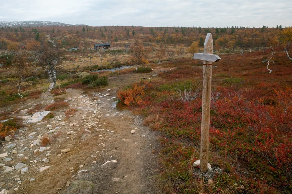
Pöyrisjärvi Wilderness Area has no marked hiking trails, but, as with other wilderness areas, this does not mean that there are no trails at all, as people have been walking in more or less the same directions for centuries, forming what are known as folk trails.
There are two such folk trails in the Pöyrisjärvi Wilderness Area that are worth checking out if you travel to the region.
But first, an important note for those who want to hike into the remote parts of the wilderness.
Keep in mind that the wilderness contains large bogs and, under no circumstances should you attempt to go through them, even if you think it would be faster than going around them. You will spend considerably more effort crossing these bogs than making a loop around them, even if that means dozens of kilometers of hiking. It’s easy to fall and twist an ankle in these bogs, so walking around them is the better choice.
The Hetta—Näkkälä—Pöyrisjärvi Trail is the most famous route in the area. It begins in the village of Hetta and follows the old postal road to the village of Näkkälä north of it toward the Norwegian border.
In the beginning, this is a marked trail of 26 km (16.1 miles) in length. From Näkkälä, you continue to Pöyrisjärvi Lake along an unmarked route, which is nonetheless clearly visible in the open Lapland landscape, with lots of landmarks such as lakes and hills for you to use for navigation. The length of this section is another 19 km (11.8 miles), and the total route is 45 km (27.9 miles) long.
Kalmakaltio—Kalkujärvi—Pöyrisjärvi—Näkkälä is another unmarked but also easy-to-follow hiking route through the entire Pöyrisjärvi Wilderness Area. It travels from the village of Kalmakaltio in the southeast near the border of Lemmenjoki National Park to the village of Näkkälä via Kalkujärvi and Pöyrisjärvi.
Kalmakaltio can be reached from Nunnanen in the south of the wilderness area, which is another 19 km (11.8 miles) away, for a total distance of 112 km (69.5 miles). Keep in mind that there are no bridges on this trail, so rivers must be crossed by wading. Solid navigation and wilderness skills are necessarily for this hike.
Pöyrisjärvi is not only a hiking destination. Both of the aforementioned trails are excellent for mountain biking as well.
The area's two largest rivers: Pöyrisjoki (43 km / 26.7 mi) and the Käkkälöjoki (40 km / 24.8 mi), are challenging but are good for canoeing. You can also fish in both of them as well as in all other rivers and lakes in the area.
Just as there are no marked hiking trails in the wilderness, there are no marked cross-country skiing trails. But you can ski freely throughout the wilderness by making your own routes through the woods.
You can also follow the several permanent snowmobile trails that lead from Hetta northward toward the village of Näkkälä and over to the Norwegian border, and on to the village of Nunnanen in the east. There are also at least three tracks leading west from the village.
The nearest major ski resort, Levi, is located 120 km (74.5 miles) to the south of the village on the eastern border of Pallas-Yllästunturi National Park. It is actually the largest and most famous resort in Finland.
Before you start hiking in the wilderness (or right after, if you enter from some of the eastern entrances to the territory) be sure to visit the famous Fell Lapland Visitor Center. This is the main visitor center in this part of Lapland, and it is located right in the village of Hetta.
The center’s free Vuovjjuš-Kulkijat exhibition will introduce you to the nature of Lapland and to Sámi culture. You can also visit an art exhibition, which changes from time to time. There are Nature Talks and numerous other events held at the visitor center during the year, too.
At the center, you can also buy maps and local products and enjoy a tasty treat at the Café Peura. For breakfast, there is in-house baked bread, fresh coffee, and the purest Lapland water. The café’s weekly lunch menu includes dishes such as chicken leaf steaks with grilled vegetables and bearnaise sauce, and locally caught pike lasagne.
Fell Lapland Visitor Centre (Tunturi-Lapin luontokeskus)
Peuratie 15, 99400 Enontekiö, Lapland, Finland
+358206397950
Open year-round with seasonal hours
The general regulations are the same as for other wilderness areas. The three main rules are:
The emergency phone number in Finland is 112. It is also good to leave information about your hike with the staff of the Fell Lapland Center and to report back to them when you’re done hiking.
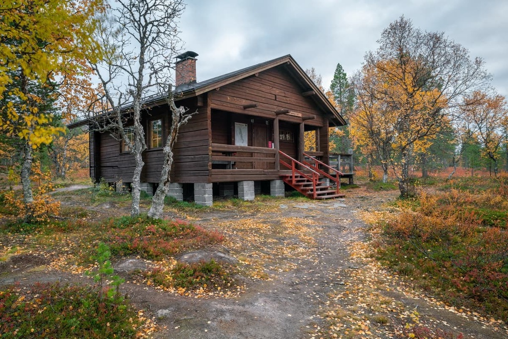
In Pöyrisjärvi Wilderness Area or close to its borders, there are seven open wilderness huts (free of charge), which are intended for one to two nights stays.
Six of these huts are located in the eastern part of the territory. They include:
The main hut, Bievrrašjávri / Pöyrisjärvi, which has 12 beds and is located on the southern shore of Pöyrisjärvi Lake, is partly a reservable hut with two extra beds.
It means that in addition to “open” beds you can book some beds in the hut in advance for €12–15 per night per person. Making a reservation may be a wise decision, given the hut’s location on the lake.
Before and after hiking, you can easily find accommodation in Hetta, Nunnanen, Leppäjärvi, Palojärvi, and other villages of Enontekiö. There are at least a few hotels in Hettal, caravan spots and campsites, and a lot of holiday cottages.
Hetta is the main village in the Enontekiö municipality of Lapland. It is located on the shore of a large and picturesque Ounasjärvi Lake. The village was founded in 1877. Today it has 1,818 residents (2021), many of whom are Sámi.
The main architectural and cultural attraction of the village, which can be missed only if you never leave your accomodation whole time you are there, is Enontekiö Church (Enontekiön seurakunta in Finnish). It was built in 1952 mainly with the support of American Lutheran Christians on the site of an old church that was destroyed in the Lapland War in October 1944.
The design of the church is the work of three local artists:
The second main attraction in the town is the Enontekiö Local History Museum, which is made from several buildings that were moved to Hetta from other places in Lapland. This includes the nineteenth-century farmhouse from Raattama village, a storehouse and a living room from Ylikyrö Village that was built in the eighteenth and nineteenth centuries, and a sauna from Muotkajärvi village that was built in 1937.
The third main attraction in the town could be Enontekiö Airport, which is located 9 km (6 mi) to the west of Hetta but it no longer has regular flights. The nearest Finnish airport is Kittilä, which, by the way, is a great alternative to flying to Rovaniemi.
In addition to Hetta, the municipality includes more than 20 towns and villages, the largest of which are Karesuvanto, Kelottijärvi, Palojoensuu, Vuontisjärviu.
You can learn more about the municipality on its official website, EnontekioLapland.com, as well as on the official website of the region, Lapland.fi.


