
Scan the QR code and open PeakVisor on your phone
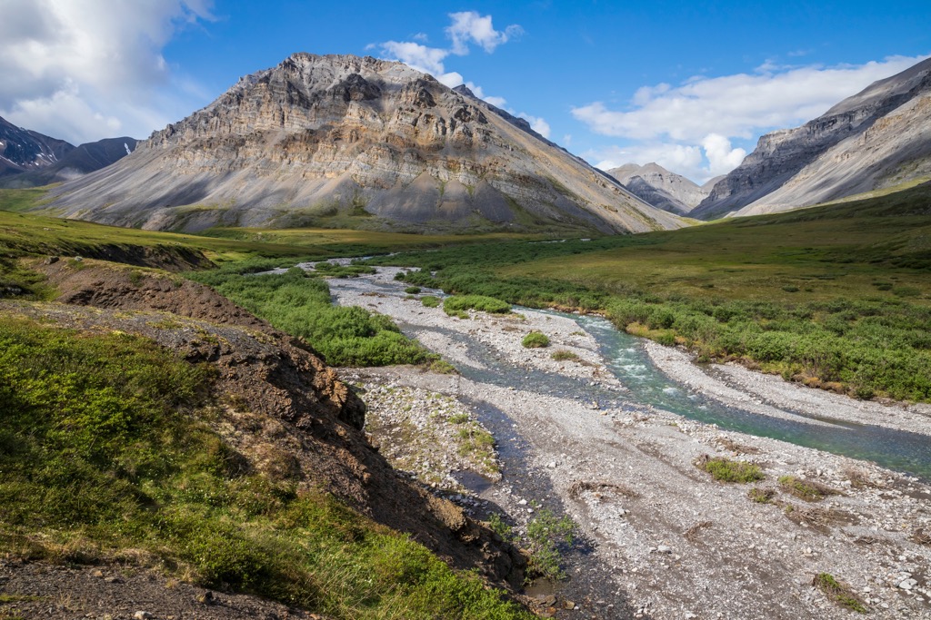
Located in the Brooks Range of Alaska, USA, the Gates of the Arctic National Preserve is part of the greater Gates of the Arctic Wilderness. Their preserve is broken up into two sections that border Gates of the Arctic National Park. Mount Kiev (7,776 ft/2,370 m) is the tallest of the preserve's 11 peaks and it is found overlooking the northeast corner of the preserve.
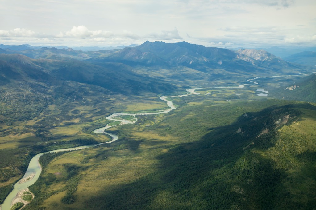
Gates of the Arctic National Preserve is in the Brooks Range of Alaska, USA, and is part of Gates of the Arctic National Park and Preserve. Gates of the Arctic National Park and Preserve is the northernmost park in the US, and it encompasses 13,238 square miles (34,287 square kilometers) above the Arctic Circle.
The Dalton Highway runs near the eastern border of the park and preserve; however, most visitors fly into the park from Fairbanks. There are no established roads, facilities, campgrounds, or trails in the park and the park status is intended to maintain the pristine quality of the area.
There are two distinct areas in Gates of the Arctic National Preserve, which are adjacent to Gates of the Arctic National Park. One area is adjacent to the southwest corner of the park, and it encompasses part of the Schwatka Mountains. The second area is adjacent to the northeast corner of the park and it encompasses the northern slopes of the Endicott Mountains.
The primary difference between the areas designated as a national park and the areas designated as a national preserve are regarding hunting rights. Gates of the Arctic National Preserve has permits for sport hunting and trapping while sport hunting is not permitted in the national park.
However, subsistence hunting is permitted for rural Alaskan residents in Gates of the Arctic National Park. Furthermore, subsistence legislation also permits rural Alaskans to obtain any wild, renewable resources for personal and family consumption as food, shelter, fuel, clothing, tool, and transportation. The legislation also allows for the making and selling of handicrafts from the non-edible parts of any wildlife they obtained.
The subsistence legislation has made it possible for rural Alaskans to continue living their independent lifestyles in the rugged wilderness of Alaska. There are ten small communities around the park that depend upon the park resources for their subsistence.
Gates of the Arctic National Park and Preserve are part of the federal program to preserve the natural landscape and resources. The following are some of the other parks and preserves near Gates of the Arctic:
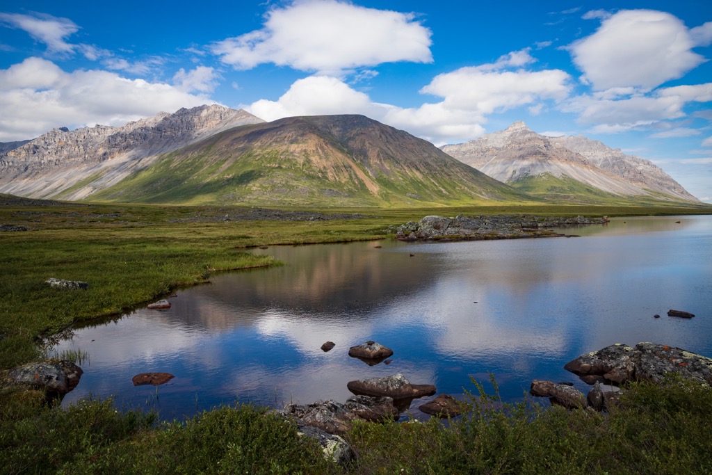
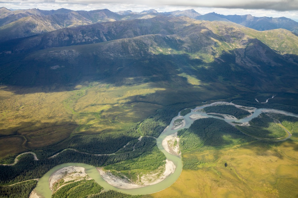
Gates of the Arctic National Preserve’s two areas are located in the Schwatka and Endicott Mountains of the Brooks Range in northern Alaska. The two areas of the preserve are on different sides of the continental divide where the southeast area’s watershed flows to the Pacific Ocean and the northeast area’s creeks and rivers flow into the Arctic Ocean.
The Brooks Range was formed at the same time as the Rockies in Canada and the United States, during the Laramide orogeny. The Laramide orogeny lasted from about 80 million years ago to about 35 million years ago and was caused by the subduction of oceanic tectonic plates.
The eastward subduction of the Farallon plate is primarily responsible for the Rocky Mountains along the west side of continental United States. The Farallon plate subducted beneath the continent at a relatively small angle which caused significant uplift and the high elevations of the US Rockies.
The northeast movement and subduction of the Kula plate created the Canadian Rockies and the northern Mackenzie Mountains and the Brooks Range. The subduction of the Kula plate beneath the continent was quite steep and while it still compressed the ancient continental margin to form the Canadian Rockies, there was much less uplift compared to the southern Rockies.
The Canadian Rockies generally have lower elevations than the ranges in the US; however, the Canadian Rockies are typically more prominent than their southern counterparts. Prominence measures the distance between the elevation of a summit relative to the surrounding terrain.
While the Brooks Range are geographically distinct from the Rockies, they are geologically connected and often seen as the northern extent of the Rockies.
The Kula plate completely subducted beneath North America; however, the Farallon plate still has small remnants, such as the Juan de Fuca plate which is off the coast northern California, Oregon, and Washington.
While the orogeny that created the Brooks Range only started about 80 million years ago, the rocks that form the range were created as much as 400 million years ago, during the Devonian. Most of the peaks are formed from limestone, sandstone, and shale that were deposited during the Cretaceous upon and older volcanic terrane.
Some of the volcanic rocks, such as ultramafic rocks, basalts, and cherts can be found among the peaks of the southern section of the national preserve. While not part of the preserve, the Arrigetch Peaks are made of granite and surrounded by schist.
Granite is created when magma rises near the surface of the Earth’s crust and slowly cools and the heat of the intrusion metamorphized the surrounding sedimentary rocks to make the schist.
The Arrigetch Peaks are in the adjacent Gates of the Arctic National Park and are a good example of how much erosion occurred since the formation of the Brooks Range. It is estimated that as much as 3 miles (5 km) of rock eroded to expose the current topography of the mountains in Gates of the Arctic National Park and Preserve.
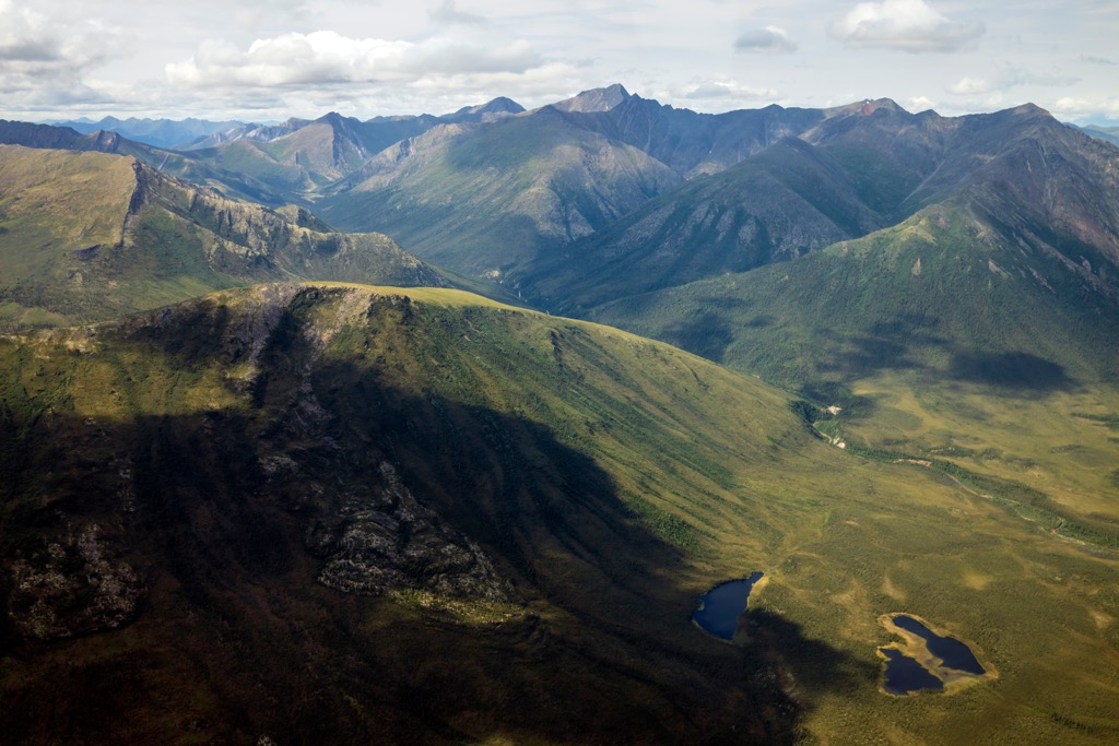
The most recent erosional events are linked to the glacial maximums that occurred in the Brooks Range during the Pleistocene. While the interior of Alaska was mostly ice-free, significant glaciation occurred in the Brooks Range, carving sharp peaks, ridge, valleys, and lakes. Some of the Pleistocene glaciers in the Brooks Range only melted about 1500 years ago.
As the glaciers melted, they left behind deposits of glacial till and debris. The layers and deposits of debris tell the history of the glaciation that formed the mountains of the national preserve as we see them today.
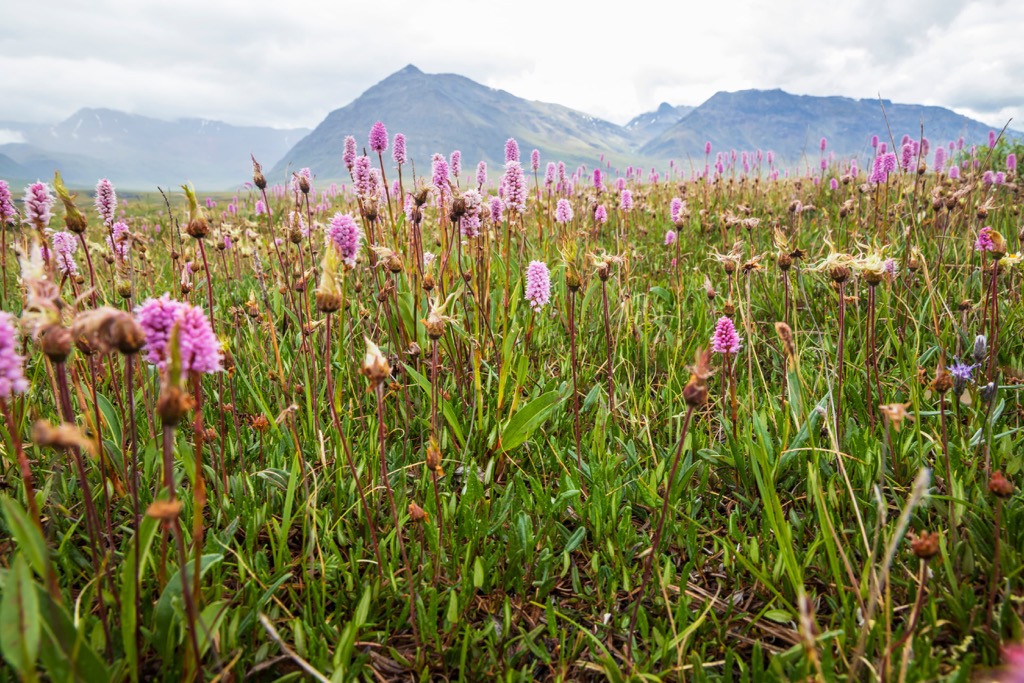
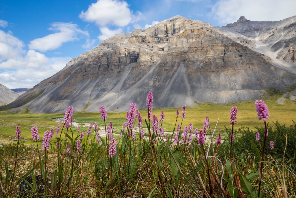
The southern half of Gates of the Arctic is covered by the great boreal forest that circles the northern latitudes of the Earth while the northern half of the park is the arid landscape that has been referred to as the “Arctic desert”.
The boreal forests are primarily a mix of black and white spruce, as well as poplar. Additionally, there are swaths of aspen and birch, along with thickets of shrubs, meadows, and muskegs. The plants have adapted to grow in thin, nutrient poor, and inadequately drained soils due to the shallow permafrost.
However, despite the perceived hardships that must be endured to thrive in the north, the boreal forests are incredibly lively and productive. The vast quantity of insects draw birds from across the world so that their young can have ample supply of protein to grow. Swainson’s thrush flies at least 7,000 miles (11,200 km) from South America and the arctic terns that come from Antarctic waters as part of the longest migration of any bird in the world.
Caribou and moose migrate through and live in the park. More than 500,000 caribou from the Central Arctic, Western Arctic, Teshekpuk, and Porcupine herds migrate through the park to their northern grazing grounds in the summer and the southern forests for the winter.
The park and preserve are also home to muskoxen, timber wolves, wolverines, coyotes, lynx, Arctic fox, porcupines, river otters, beavers, ground squirrels, lemmings, voles, muskrats, snowshoe hares, black bears, grizzly bears, Dall’s sheep, and many other species.
There are estimated to be over 130 grizzly bears in the national park and preserve and the park is the northernmost range limit for the Dall’s sheep. All counted, there are over 900 different species of flora and fauna that inhabit and thrive in the harsh climate of Gates of the Arctic.
Most people come to Gates of the Arctic today to immerse themselves in nature and experience the solitude of the arctic wilderness. On average there are only 10,000 visitors to the park and preserve each year, giving many opportunities for uninterrupted solitude during your northern adventure.
In 1978, after decades of petitioning for the creation of a national park in the Brooks Range of Alaska, Gates of the Arctic was designated as a national monument. Two years later the area was redesignated as Gates of the Arctic National Park and Preserve.
The name of the park dates back to the 1930s when Bob Marshall, a wilderness activist, was exploring northern Alaska. As he traveled the North Fork of Koyukuk River, he encountered a pair of mountains, Frigid Crags and Boreal Mountain, on either side of the river that framed the route to the north. Marshall named the pass “Gates of the Arctic”.
Marshall was certainly not the first person to explore the Brooks Range; however, it was only near the end of the nineteenth century that the interior of Alaska was explored by non-indigenous people. The Klondike gold rush of the late nineteenth century saw miners traversing Alaska on their way to the gold fields and some of the latecomers decided to try their luck along the Alaskan rivers instead of trekking all the way to Yukon.
Unfortunately for the miners that stayed in Alaska, their operation didn’t amount to much; however, they still left their mark upon the territory. Encampments, abandoned mining operations, dilapidated cabins, and rusting artifacts can still be found in the park.
Before the European descended explorers and prospectors, the territory had been inhabited by indigenous cultures for over 11,000 years. The most recent were nomadic tribes known as the Nunamiut, who are descendants of the Inupiat who came to Alaska about 800 years ago.
The last semi-nomadic tribes of Nunamiut came together in 1949 to establish the community of Anaktuvuk Pass, which is at the north end of Gates of the Arctic. The Gwich’in, an Athabaskan group, also inhabited the Brooks Range over the past 1000 years; however, they migrated south and east and now inhabit much of northern Canada.
The vast caribou herds provided the main food source for the ancient inhabitants of the Brooks Range. Archeological sites in and around the Brooks Range show that nomadic people have inhabited the area for about 12,500 years. There are sites along Iteriak Creek, which is upon the plains north of the park, that were occupied between 11,500 and 10,300 years ago.
Furthermore, discoveries include 6,000-year-old projectile points, stone knives, and net sinkers. The region was also inhabited by people that were part of the Arctic small tool tradition who inhabited the region between 4,500 and 950 years ago.
Currently there are eleven communities that surround the park, where the residents depend upon the natural resources of the park for their sustenance. The local rural Alaskans of these communities are carrying forward long held traditions of hunting and gathering in the wilderness.
The park and preserve may appear as an uninhabited, vast, and tractless wilderness; however, there are over 10,000 years of human traditions that have impacted the park and the people around it. While it is easy to get caught up in the majesty of the landscape and the natural beauty, visitors would gain great insight by also learning and immersing themselves in the human history of the area.
People have trekked through the Brooks Range for thousands of years; however, traveling through the harsh northern wilderness without the intent to hunt or migrate to a seasonal camp is a modern development.
There are no roads or official trails in the park and travelers in the park are generally lucky to travel 5 mi (8 km) a day through the thick vegetation and unforgiving topography. Camping is permitted throughout the park; however, there are certainly no facilities. Gates of the Arctic is the least visited national park in the US National Park System.
The park’s headquarters are in Fairbanks, where visitors can start their park experience by boarding a flight to one of the communities near the park. Other options to enter the park and preserve include hiking from the Dalton Highway; however, this route does involve crossing a river.
Visitors may come to the park for hunting, fishing, river running, mountain climbing, hiking, or mountaineering. These are all wonderful opportunities to immerse yourself in the wilderness. However, it must be noted that Gates of the Arctic is a very remote park and emergency services may take days to reach your location. All visitors to the park must know how to care for themselves and their party while traveling in the backcountry.
If you don’t feel that your skills are up to par to travel and explore Gates of the Arctic; however, you’d still like to experience the rugged Alaskan park, there are several guided options that are available. Guided and supported tours include flightseeing, fly-in fishing and hiking, or supported overnight camps.
While there are many communities that surround Gates of the Arctic National Park and Preserve, none of them have any major infrastructure to support tourists, except for their airports that provide access to the wilderness of the park and locals that offer guiding services. Fairbanks is the only city that is relatively close to the park, and it is the primary portal to Gates of the Arctic.
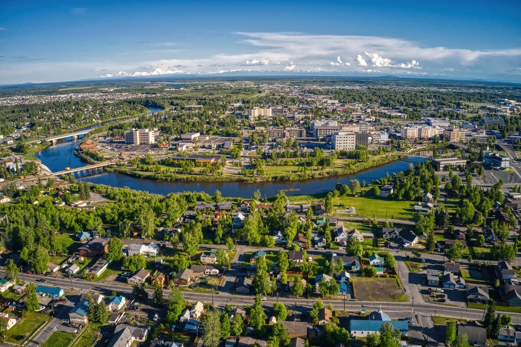
Fairbanks is about 180 mi (300 km) southeast of Gates of the Arctic National Park and Preserve. The city has commercial and charter flights that lead to the northern communities around the park, making it the gateway to the northern parks and remote areas of northern Alaska.
Fairbanks is the largest city on the interior of Alaska, and the surrounding Fairbanks North Star Borough is the second most populated metropolitan area in Alaska, after Anchorage. The city is in the Tanana Valley and it straddles the Chena River. The White Mountains and Yukon River are north of the city.
During the summer, most visitors to Fairbanks are cruise ship passengers that purchased packages to travel and stay overnight in the city. Otherwise, most visitors come to Fairbanks during the winter to see the northern lights, ice carving, and winter sports.
The Chena River State Recreation Site is a small area in Fairbanks that has hiking trails, a campground, and a boat launch for the river. About 30 mi (48 km) outside of Fairbanks is the Chena River State Recreation Area that has campgrounds, hiking, fishing, public cabins, a shooting range, and trails for dog sleds, OHVs, and snowmachines.


