Scan the QR code and open PeakVisor on your phone
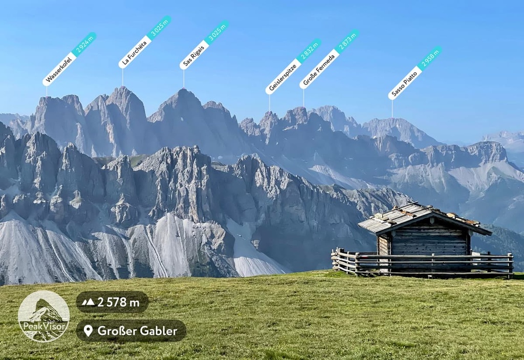
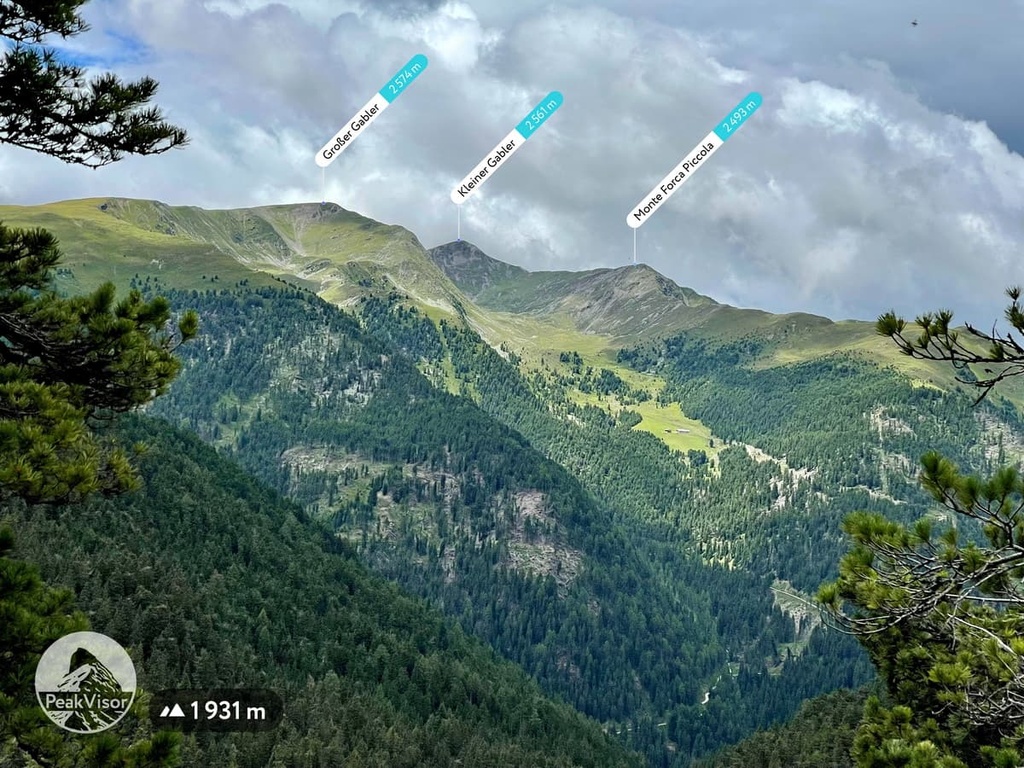
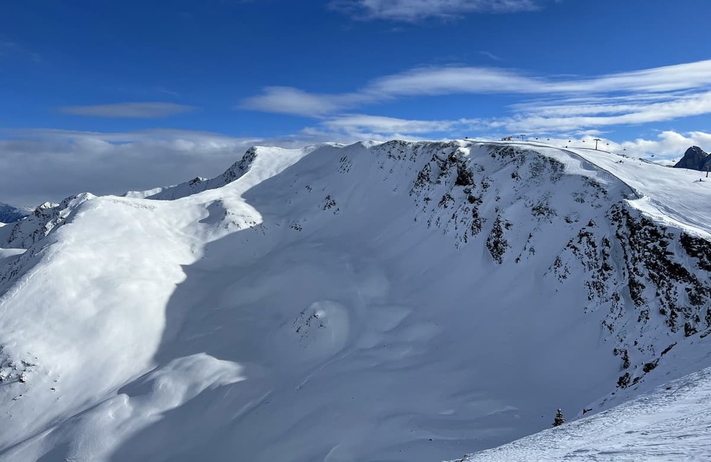
Lüsener Berge, also known as the Plose or Lüsen Alps, is a small group of peaks located in the northern Dolomites in the South Tyrol region of Italy along the country’s border with Austria. Besides the 27 named mountains in Lüsner Berge, the group also offers magnificent views of the surrounding groups both in the Dolomites and the Austrian Alps. In particular, you can see these ranges from the summit of Großer Gabler (2,576 m / 8,445 ft), the highest and the most prominent peak of the Lüsener Berge.
The first part of the name of the group, Lüsen or Lüsener, is derived from the name of the small town or village at its center, which is also its largest and most important settlement. Considering the bilingualism of South Tyrol, in Italian, the German town name Lüsen is spelled Luson.
There is no consensus regarding the origin of the word itself. The most common theory is that it comes from words in the language of some ancient Germanic tribes. These words include “lase” (stripe) and “ache” (river), which together form “Lasache.” It’s possible that Lasache was a former name for this region.
Over time, the name Lusache transformed into the current name Lüsen after going through a series of changes, which have been documented in locally written sources. It was called Lusina in 893, Lusena in 1142, and Lysen in 1265.
The second part of the name is much simpler: the word "berg" is a “mountain” in German, and “berge” means “mountains.”
So the full name of the range translates to “Mountains of Lüsen.”
Lüsener Berge is located in the district of Eisacktal / Valle Isarco, one of the eight administrative units of the province of Bolzano / South Tyrol, which in turn is one of two in the autonomous region of Trentino-Alto Adige / Südtirol alongside Trentino.
The Lüsener mountains are surrounded by three large and famous valleys:
The range is also home to two smaller valleys in the south: Aferer Tal / Valle di Eores and Untermoital / Val d’Antermoia. These valleys separate it from the Peitlerkofel Group in the Dolomites.
In the center of the Lüsener Berge, between its two main ridges, there is the no less famous Lüsnertal / Val di Luson, which stretches from south to northwest. The Lüsnertal / Val di Luson is arguably the main valley in the Lüsner Berge.
In addition to Peitlerkofel, it is good to note also other neighboring mountain groups around the Lüsner Berge, which include the Sarntal Alps in the west, the Zillertal Alps, and the Rieserferner Group (both of which are part of the Western Tauern Alps), in the northwest and northeast, and the Braies Dolomites in the east.
The Peitlerkofel, together with the Odle and Puez groups to the south, are primarily located in their namesake Puez Odle Nature Park. The same applies to the Braies group, which, together with the Fanes and Sennes groups, is also part of the Fanes–Sennes-Braies Nature Park. Another large and famous park in South Tyrol, Naturpark Rieserferner-Ahrn / Parco Naturale Vedrette di Ries-Aurina, also lies to the north.
The quickest and easiest way to get to Lüsen / Luson is by car from Bolzano (55 km / 34.1 mi, 1 hour), from Innsbruck, Austria (100 km / 62.1 mi, 1 hour 30 minutes), or from Cortina d’Ampezzo (73 km / 45.3 mi, 1 hour 45 minutes). In all three cases, you can also make the journey to Lüsen by local bus, but doing so from Cortina d’Ampezzo isn’t very straightforward.
That said, South Tyrol is also very active in the development of electric transportation options, particularly when it comes to electric cars and bicycles. You can rent electric bikes in almost any city and ride effortlessly to your destination on special bicycle paths, combining the trip with active and healthy recreation.
In the case of the Brixen / Bressanone to Lüsen / Luson route, a distance of 26 km (16.1 mi) round trip does not seem long at all. In particular, you can make this trip along Provincial Road 30 (Strada Provinciale 30 Luson).
Anyway, check in advance where the charging stations are for these electric bikes. It is much more difficult to move a discharged electric bike in the mountains than you might think.
The geology of the Lüsener Berge is generally the same as that of the Dolomites as a whole. It contains a large quantity of its parent range’s namesake rock, dolomite.
However, recognizable dolomite is only the “visible part of the iceberg” in the Lüsner Berge and the Dolomites.
The base of the Dolomites and the South Tyrol region, in particular, is crystalline igneous rock. Above it, there is Brixen granite, which is named after the town of Brizen. It formed at the northern boundary of the Southern Limestone Alps about 280 million years ago, in the Lower Permian.
Then, during the Upper Permian, sedimentary rocks such as Gröden sandstone formed. Finally, the massive carbonate platforms of dolomitic rocks appeared in the Triassic.
Specifically in the Lüsener Berge, we do not see the range’s dolomite outcroppings very clearly, or at least not as clearly as in the neighboring groups of Peitlerkofel and Braies. As a result, this range consists primarily of earlier granitic rocks, which is also the case in the Fiemme Mountains.
Above I have already listed many of the features of the landscape of the group—valleys, neighboring groups, and so on. But at least three more important thing should be added to the list, which makes Lüsener Berge the place we know it:
Lüsner Berge is one of the 24 groups in the Dolomites according to the classification of the German-Austrian Alpine Club (AVE) alongside other nearby groups such as Pala, Tre Cime, and Sella.
According to another classification of the Alps, the Italian SOIUSA, this group also belongs to the Dolomites, but it is part of the Gruppo Plose-Putia (Sas di Putia is an Italian name for the same Peitlerkofel), which, in turn, is located in the supergroup Dolomiti di Gardena. This supergroup is part of the subsection Dolomiti di Gardena e di Fassa of the Dolomiti.
According to the SIOUSA classification system, the Plose-Putia group is divided into three subgroups:
The Gruppo della Putia include also two other subgroups: Catena delle Odle d’Eores and Massiccio del Sass de Putia.
The last two subgroups—Sottogruppo della Plose and Costiera di Luson—are actually the two mountain ranges that make up the Lüsener Berge. The first of these is a monolithic and compact massif consisting of a series of peaks called Plose to the south of the city of Lüsen / Luson. The second is an elongated arc that runs from south to northwest along the northern part of the city.
The main peaks of the Plose are relatively low in elevation as they are all less than 2,500 m (8,202 feet) high with gentle slopes. Some of the major peaks in the range include:
It is believed that the name Plose comes from the pre-Roman word “blese,” which means "steep meadow.
There are three main reasons why you might want to visit this region. First, it is home to the famous Plose ski area. Second, the range serves as a great lookout point that overlooks the Odle Group and the rest of the Alps. Third, Plose used to be the regional base of the Italian Air Force. In fact, the air force buildings and radar antennas are still located in the range, but have not been used for their intended purpose since the late 1970s.
The major peaks of the second mountain range that’s located to the north of Lüsen / Luson include:
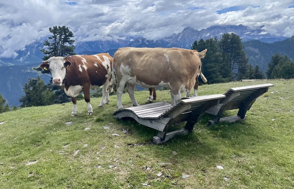
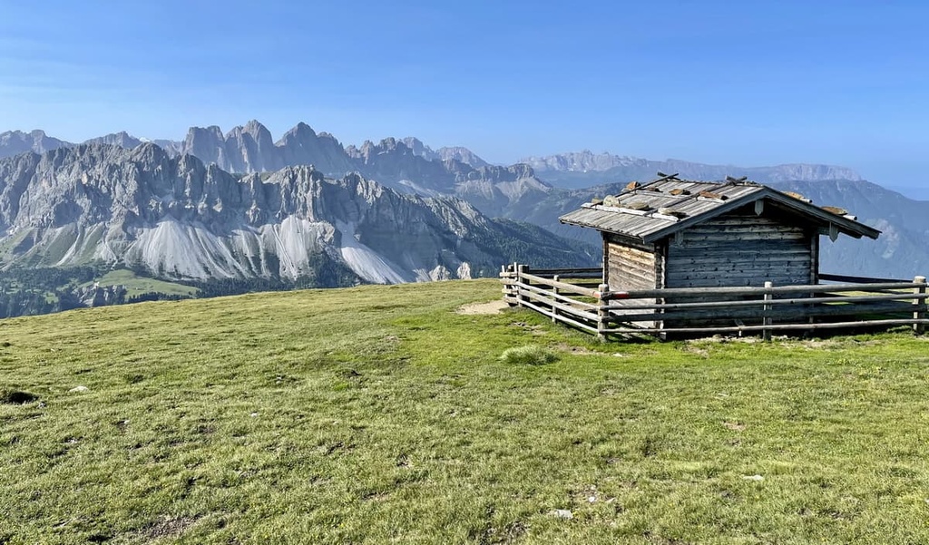
As I noted, these are the highest points of the region’s vast high alpine pastures, which are famous for their family-friendly hiking opportunities.
The Lüsener Berge Group is an ideal place for solo and family hiking, thanks to its compact size, the relatively low elevation, and its stunning panoramic views of the Dolomites and the Alps.
There are many different hikes that you can enjoy in the group, though most are of a moderate level of difficulty. Most of them also start in the center of Lüsen / Luson or in one of its neighboring hamlets.
The main hiking trail in the group is the loop hike to the summit of Plose / Monte Telegrafo and the Ochsenalm Alpine farm behind it.
This hike begins from the settlement of Croce / Kreuztal, where you can easily get from Brixen / Bressanone. The distance of the route is 11 km (6.8 mi) and it has an elevation gain of 548 m (1,797 ft). Most people can hike this route in about 4 or 5 hours.
Another famous route in the Lüsner Alps is the scenic hike on the Lüsen Alm high plateau in the northern ridge of the group.
This is a point-to-point route with a start and end at the two parking lots just above the Lüsen/Luson: Herol and Schweiger Böden, or vice-versa. The distance of the route is 8.2 km (5 mi) with an elevation gain of 396 m (1,299 ft). Most people can hike this route in about 3 hours.
Lüsener Berge Group also has many other routes, which can be hiked both in the summer and winter.
For example, one of them leads to the top of Campill, another to the Chapel of Pianer Kreuz, and another to the summit of Glittner Joch. There are also hikes to the Halslhütte and to Tschupwaldsee Lake. In winter, you can also climb Astjoch, the main peak of the Lüsner Alm.
During the summer season in the Dolomites, which is officially from June 21 to September 21, when the mountain huts and cable cars are open, there are two long hiking routes in Lüsner Berge that open up a world of adventure beyond this small mountain range.
The Dolorama Trek is a four-day hiking route in a breathtaking South Tyrolean landscape that features spectacular views. It goes from Rodenecker / Lüsner Alm to the town of Laion / Lajen in the southwest of the group near the city of Chiusa / Klausen via three alpine huts: Maurerberghütte, Schlüterhütte, and Schutzhütte Raschötz / Rifugio Resciesa.
The route length is 61 km (37.9 mi) with an elevation gain of 2,356 m (7,729 ft). Most people can hike this route in a total walking time of 20 hours.
Alta Via 2 is one of the two longest alpine hiking trails in the Dolomites, on par with the Alta Via 1, which is 160 km (99 mi) long and takes 11–14 days to complete.
If you start from the very beginning of the route in Brixen / Bressanone, you will arrive at Schlüterhütte (also known as rifugio Genova) in the Peitlerkofel Group by the end of day 2 by crossing the southern ridge of the Lüsener Berge in two days via rifugio Plose.
The length of this two-day hike is 42 km (26 mi) and it has an elevation gain of 2,400 m (7,874 ft). This route has a total hiking time of 11:30 h.
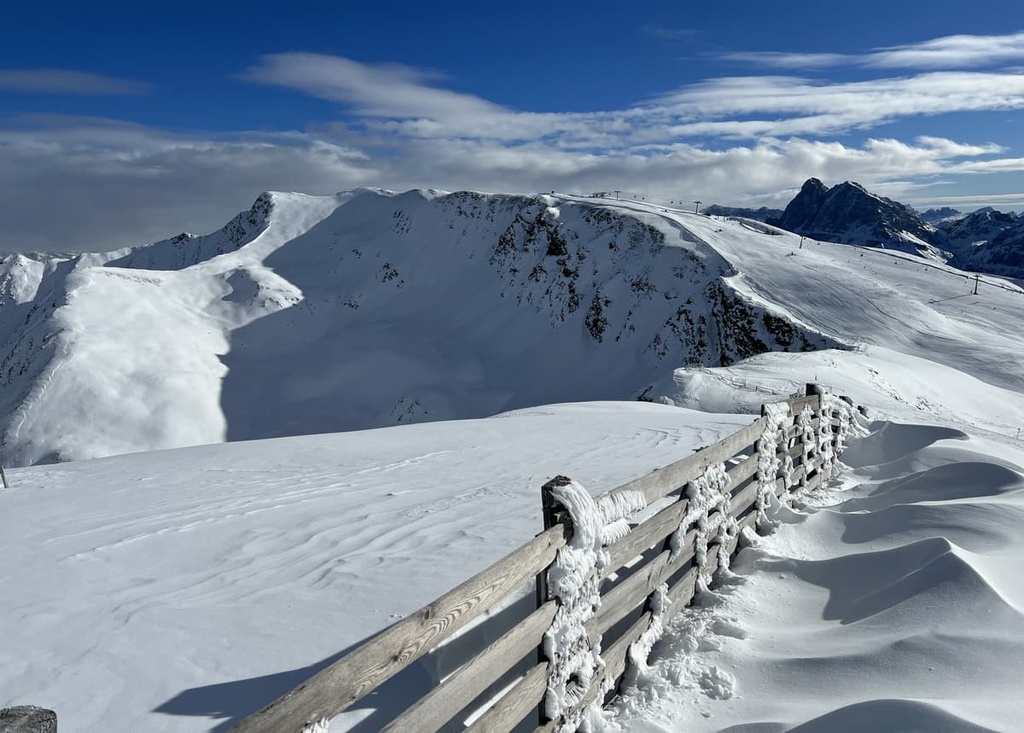
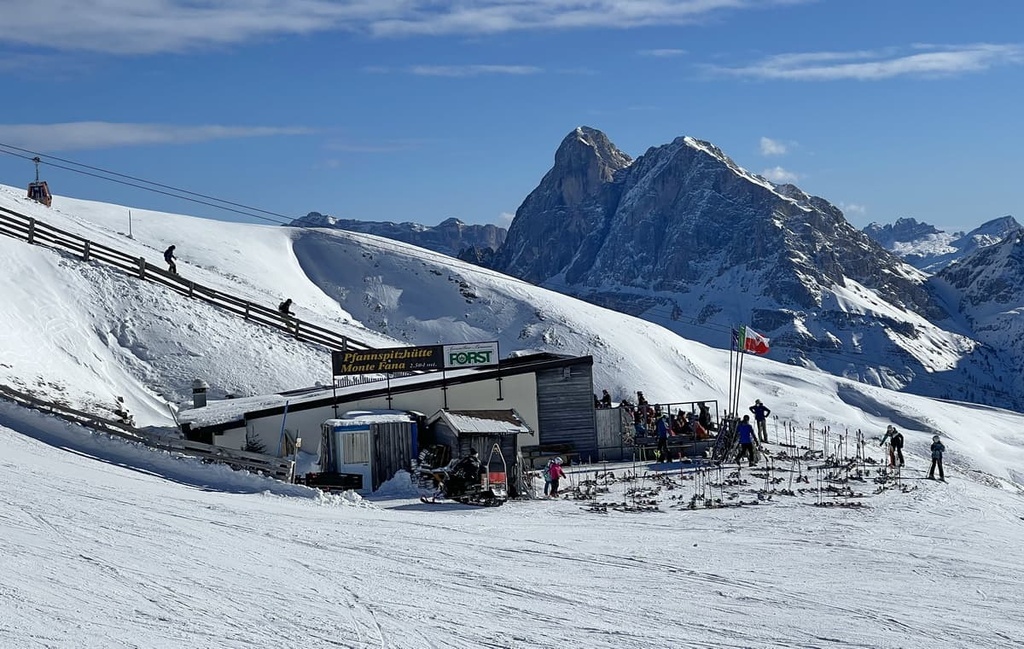
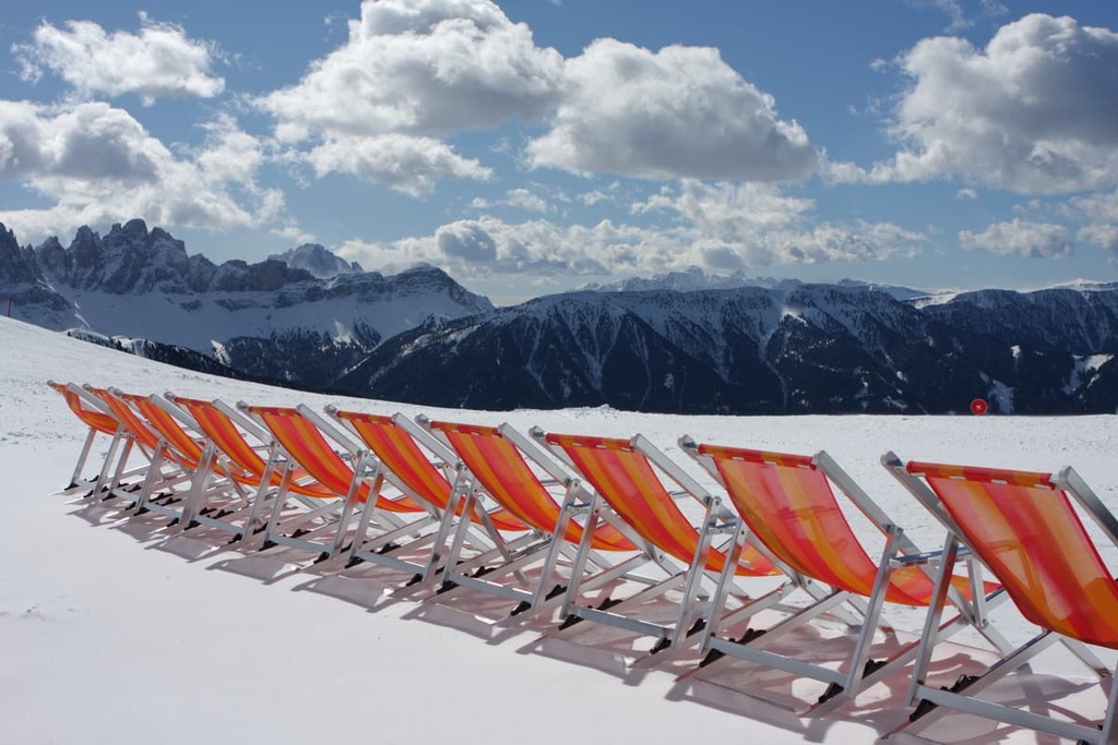
The Plose Ski Resort is quite large, so it is a popular destination for ski fans in the region. It is situated right on the Plose mountain to the south of the town of Lüsner / Luson.
The ski area has a vertical elevation change of about 2,000 m (3,280 ft). At the resort you will find 42.5 km (26.4 mi) of ski trails of varying difficulty, in particular:
The longest run in the resort and in the whole of South Tyrol, which is called “Trametsch”, deserves a special mention. It is 8.2 km (5 mi) long and has a vert of 1,400 m (4,593 ft). Trametsch is an advanced ski trail that’s legendary in the region. If you have the skills to handle this route, it’s certainly worth skiing at least once, if only to be able to tell your friends about it later!
In addition, the resort features a half-pipe for snowboarders as well as racecourses for skiing and snowboarding, a funpark and kids camp, a ski shuttle bus from Lüsen, and other services. There are seven ski lifts in total to help you get up the slopes during your stay.
Remember that you can check out all the ski resorts in Trentino-Alto Adige / Südtirol with real-time information about open or closed lifts on the resort’s page in PeakVisor.
When traveling in the Lüsener Berge group, be sure to visit the region's official tourist center, which is located in its main town:
Tourist Office Lüsen / Luson
Dorfgasse, 19, I-39040, Lüsen / Luson, BZ, Italy
+390472413750
Opening Hours: Monday to Friday between 8 am and 1 pm
Note that from November to April, the tourist office is closed on Wednesdays. In July and August, it is also open on Saturdays from 8 am to 12 pm.
When hiking in the Lüsener Berge, you can stay in one of the classic alpine huts (rifugios), which are quite abundant for such a small mountain area. You can either book a place in a shared room for 4–10 people or reserve a private double or triple room for you and your family and friends.
The main huts in the range are the following:
Before and after your hike, you can easily find many regular hotels, apartments, and B&Bs in Lüsen/Luson. The town is a great basecamp if you’re primarily interested in venturing out on day trips anyway.
Although Lüsen / Luson is a very small town, it includes seven hamlets: Croce / Kreuz, Masi / Huben, Berg / Monte, Petschied / Pezzè, Rungg / Ronco, Flitt / Valletta, and Villa / Dorf, which you can easily visit during a city tour.
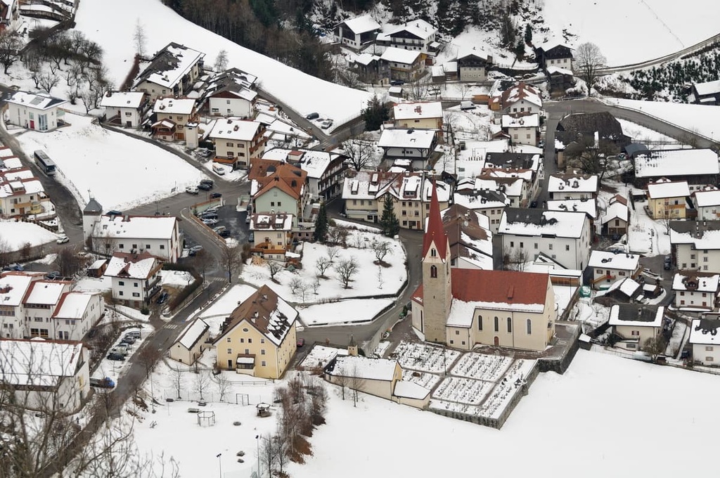
A total of 1,500 people (2020) live in the town and approximately 98 percent speak German, 1 percent speak Italian, and 0.83 percent speak Ladin as their first language. Ladin was still known and spoken by the population at the end of the seventeenth century but it became extinct around the middle of the eighteenth century.
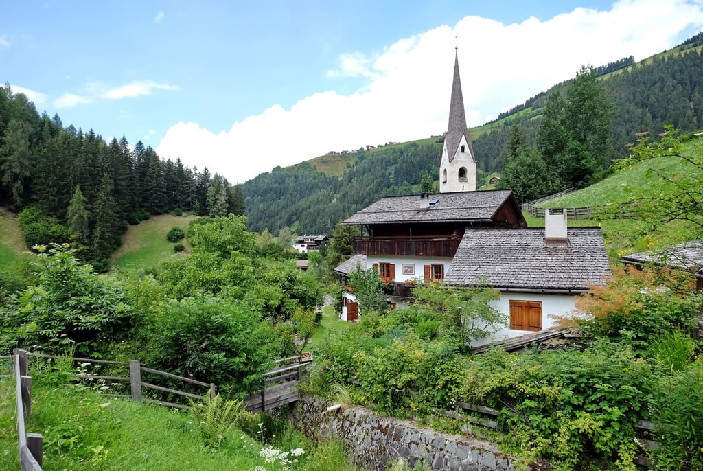
The main architectural and cultural attraction of Lüsen / Luson is the Baroque style Church of Saint George (Chiesa di San Giorgio / Kirche St. Georg) which features a high tower that is visible from afar. It was built in the twelfth century and was restored in 1502, again during the eighteenth century, and again in 1921.
Other important churches and buildings in the town include the fifteenth-century Chapel of St. Kilian (Cappella di San Kilian), the Old Pagan Pilgrimage Church of St. Nicholas (Antico Santuario Pagano di San Nicolò), and the Moar Residence (Residenza Moar / Mayrhofen), which was the largest farm in the area for a long time.
One of the interesting hidden facts about Lüsen / Luson is that during the Christmas of 2010, it donated the Christmas tree for St. Peter’s Square in the Vatican. The tree, chosen among 100 others on the local Lengerei farm property, was 34 m (111 ft) high and it weighed about 5 tons.