
Scan the QR code and open PeakVisor on your phone
Xiuguping Special Scenic Area has 2 named peaks. The highest is Xiuguluan Shan at 3,860 m. Other notable peaks include Dasuiku Shan.
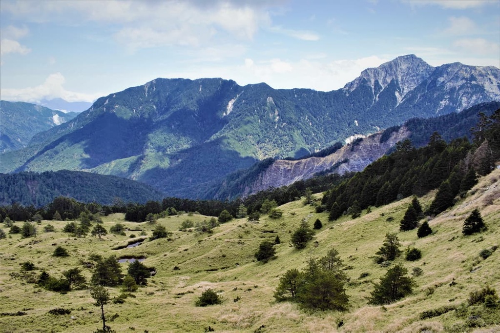
In the northern region of Yushan National Park (玉山國家公園) in central Taiwan lies the stunning deadwood forest of Xiuguping Special Scenic Area (秀姑坪特別景觀區). The special scenic area contains only 2 peaks, the tallest of which is Xiuguluan Shan (秀姑巒山) at 3,860 metres (12,073 ft) in elevation.
The small protected region of Xiuguping Special Scenic Area is located in two counties: Xinyi Township (信義鄉) of Nantou County (南投縣) and Zhuoxi Township (卓溪鄉) of Hualien County (花蓮縣).
Taiwan’s central region is notoriously hilly, and most of Taiwan’s highest peaks extend toward the heavens. Yushan (玉山), the tallest mountain in Taiwan at 3,952 metres (12,966 ft), stands imposingly tall to the east of Xiuguping Special Scenic Area.
Besides Xiuguluan Shan, Dashuiku Shan (大水窟山) is the only hill found in Xiuguping Special Scenic Area. Both Xiuguluan Shan and Dashuiku Shan are Baiyue, meaning they are part of the Taiwan 100, a collection of the best summits to climb on the island. In fact, Xiuguluan Shan is among the top 10 highest mountains in Taiwan. It’s also the tallest peak of the Central Mountain Range (中央山脈).
Located on the saddle between Xiuguluan Shan and Dashuiku Shan, at 3,480 metres (11,417 ft) in elevation, lies the eerie burnt wreckage of what once was a thriving Yushan juniper woodland.
Roaring forest fires obliterated the flourishing land into the ashen remains of charred wood that we see today. Stumps of sallow white tree trunks with abnormally twisting and curling limbs now dominate the region. This once fire-ravaged area is known as the white wood forest.
As the topography in the region is exceptionally rugged and mountainous, Xiuguping Special Scenic Area has a surprisingly cold climate. In areas above 2,500 metres (8,202 ft), the average temperature is a crisp 52°F (11°C). However, this figure plummets to a nippy 43°F (6°C) for elevations over 3,500 metres (11,482 ft).
The steep terrain in the region is exposed to the onslaught of storms from the wintery northeast monsoon and the destructive typhoons in the summertime. Thus, the mountainous region endures a high annual rainfall of 3,000 to 4,700 mm (118 to 185 in) and an average daily relative humidity of about 80 percent.
Xiuguping Special Scenic Area is also surrounded by a number of other protected regions. Some of the nearby areas to check out include:
The precipitous peaks that run along the spine of Taiwan were created around the same time as the island itself.
About 3 million years ago, the collision of the Eurasian and Philippine Sea plates resulted in the uplift of the seabed in the area that is now Taiwan. The impact from this collision created steep peaks that grew into the mountains that we see today.
There are five major mountain ranges in Taiwan, the longest and most significant being the Central Mountain Range. It contains 59 peaks that are part of Taiwan’s top 100 mountains.
However, the range isn’t home Taiwan’s tallest peak; that privilege belongs to the Yushan Range (玉山山脈). Taiwan’s second-highest mountain, Xueshan (雪山), is part of the Xueshan Range (雪山山脈).
The other two ranges are the smaller Alishan Range (阿里山山脈) and much gentler Hai’an Range (海岸山脈).
Xiuguping Special Scenic Area’s rock strata generally date back to the time between the Eocene and Miocene epochs. The bedrock consists of a combination of phyllite, slate, and shale, with small amounts of sandstone and quartzite.
Xiuguping Special Scenic Area’s main ecological attraction is a scorched deadwood juniper forest. Luckily, the fire did not spread further than the saddle of Xiuguluan Shan and Dashuiku Shan.

There is a thriving cold temperate forest of Taiwan hemlock and Taiwan two-leaf pine visible on the mountain slopes of Xiuguluan Shan and Dashuiku Shan. Additionally, Pseudosasa japonica bamboo is one of the only plant species that can successfully grow above 3,500 metres (11,482 ft) on the hills of Xiuguping Special Scenic Area.
While climbing in the scenic area, hikers can admire the many flowers that dominate the landscape. These wild blooms are alpine Yushan hypericum, foxglove, chrysanthemum, red rhododendron, and Japanese andromeda.
The Formosan rock macaque, Taiwan sambar deer, and Formosan black bear are 3 of the 14 species of mammals found in the Xiuguping Special Scenic Area. Additionally, park officials have recorded 81 bird species, including the Mikado pheasant, vermillion bird, and the Taiwan wren babbler within the scenic area.

Surrounding the south-eastern region of Xiuguping Special Scenic Area is the Batongguan Yueling Ancient Road, which is 96 km (60 mi) long. This ancient road connects Xinyi Township of Nantou County in the east and Yuli Township of Hualien County.
During the Japanese Occupation Era, Japanese officials entered the mountainous area of Yushan National Park to subjugate the Bunun tribe who have lived in the region for countless generations. The Japanese forced the Bunun to leave their homelands and instead live on a road that was heavily guarded by Japanese policemen.
Even though the Batongguan Yueling Ancient Road is now deserted, historical remnants such as abandoned police stations and broken kitchenware remain. They serve as a stark reminder of the oppression of the indigenous people of Taiwan during this time.

The major hiking trails and areas in and around Xiuguping Special Scenic Area include:
The spectacular Badaxiu Hiking Trail brings you to the summit of Xiuguluan Shan and Dashuiku Shan, as well as the other Baiyue of Batongguan Shan (八通關山). In fact, the first few letters of these three mountains create the trail’s name, ‘Badaxiu’.
Starting at Dongpu Climbing Pass, hikers first make their way to Lele Mountain House. Hikers then head toward Batongguan Mountain Pass; however, instead of climbing Batongguan Shan, they circumnavigate the peak and trek to Xiuguluan Shan.
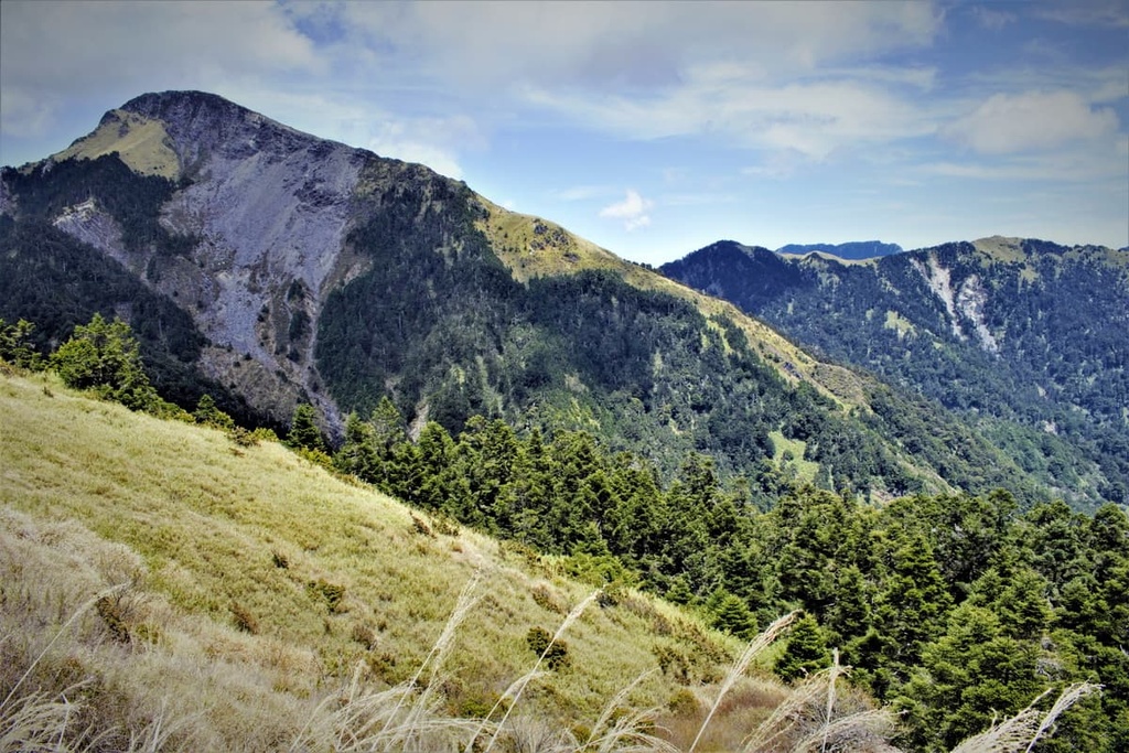
Before reaching the summit, hikers enter the white wood dead forest of Xiuguping. The dead woods sit on a vast, open plain with excellent views of the surrounding jagged peaks. Clusters of Taiwan cypress have sprouted on the plain, generating a breath of new life in a once dead environment.
The trail to the summit of Xiuguluan Shan begins to steep from here, as unsteady rock, painfully thin ridges, and near-vertical cliffs create obstacles up the last 400 metres (1,312 ft) of the path. Once hikers finally reach the summit, they are instantly rewarded with generous views of the dramatic landscape below.
The imposingly majestic behemoth of Yushan stands to the west with Mabolasi Shan (馬博拉斯山) towers overhead in the north. Hikers can note the lush Xiuguluan River Valley to the west, while Dashuiku Shan and Nandashuiku Shan (南大水窟山) rise upward to the south.
Onwards, hikers scramble their way down the steep rocky road of Xiuguluan Shan to reach the path that leads to the nearby Dashuiku Shan. While Dashuiku Shan is most renowned for the alpine Dashuiku Lake and Dashuiku Caves, these are situated on the southern slope between Dashuiku Shan and Nandashuiku Shan. If hikers wish to add these attractions to the itinerary, they will have to venture further south.
The trail to Dashuiku Shan features a grassland of Pseudosasa japonica bamboo and alpine shrubbery, set against the rippling ridges of the rocky mountain.

Many hikers enjoy the scenic landscape of Dashuiku Shan with its textured vegetation and excellent views. From the summit, Xiuguluan Shan is visible to the north, while the many peaks from Yushan rise to the west, and Nandashuiku Shan towers overhead in the south.
The historic route known as the Batongguan Yueling Ancient Road starts at Dongpu Climbing Pass in Xinyi Township of Nantou County. In a near diagonal path, it extends in a south-easterly direction toward Yuli in the Zhuoxi Township of Hualien County.
Even though you don’t get to summit any peaks on this trail, the ancient road passes by the bases of numerous hills. Then, the trail winds its way around the ridges of Batongguan Shan, Dashuiku Shan, Nandashuiku Shan, Lagulashan (拉古拉山), Rurunshan (儒潤山), Duomeilishan (多美麗山), Tushaduoshan (土沙多山), and Huangmashan (黄麻山).
The path continuously dips into lush valleys and climbs up again into alpine woodlands; thus, the vegetation on the trail tends to change quite rapidly. In the lower elevations, banyan and phoebe trees feature in the hot, subtropical environment. There are also plenty of warm-temperate ferns along the trail, too.
As the elevation increases, the vegetation transforms. Woodlands of fragrant camphor trees are succeeded by cool temperate Taiwan cypress, after which the cold-temperate Taiwan fir and pine trees stretch their pointed needles to the frosty mountain skies.
Dashuiku Shan marks the trail's halfway point, serving as a divider for the eastern and western segments of the path. The west half of the Batongguan Yueling Ancient Road is more favored among hikers due to its proximity to Yushan.
The eastern part of the trail bears the brunt of being the first line of impact against the vicious typhoons that whip their intense blows of torrential rain against the track. Thus, the trail undergoes significant damage during the typhoon season each year.
Another lengthy trail, Mabolasi Transverse Hiking Trail (馬博拉斯橫斷) takes eight days for hikers to complete, covering 94 km (58 mi) and crossing seven Baiyue. That said, it begins at the same starting place as the Badaxiu Hiking Trail and the Batongguan Yueling Ancient Road.
The path climbs the grassy peak of Batongguan Shan before making its way toward Xiugulan Shan. It also makes a scenic stop at the white deadwood forest of Xiuguping. Hikers then head north to Jupen Shan (駒盆山), which then connects to Mabolasi Shan.

The infamous Ulamang Cliff straddles the landscape between Mabolasi Shan and the Mariawen Mountain Road, which leads to Malijia Nan Shan (馬利加南山). Hikers must first cross a frighteningly narrow gravel path of only 30 cm (11 in) in width, after which they must climb up a 90-degree crumbling rock wall using ropes to haul themselves up to the top.
The trail then leads southward to the penultimate peak of the trail, Maxi Shan (馬西山). Woodlands of Taiwan red pine dominate the woods of Maxi Shan, while wildflowers add beauty to the trail. The final peak, Kaxipanan Shan (喀西帕南山), forms the eastern border of Yushan National Park.
The mountain overlooks the overgrown Taiping Valley, which features a barrage of Pseudosasa japonica bamboo and clusters of hardwood-hemlock forests.
As the Mabolasi Traverse Hiking Trail is a high mountain road that crosses seven Baiyue, hikers are submerged in dramatic mountain scenery throughout this adventure. Yushan and Xiuguluan Shan are easy to spot along the route, and astute hikers can also see Dongjudashan (東郡大山) of Danda Major Wildlife Reserve to the north.
While Yushan Main Peak isn’t located in the Xiuguping Special Scenic Area, it’s located very close by. Thus, hikers may be interested in adding the ultimate challenge of summiting Yushan Main Peak to their itinerary during a trip to the special scenic area.
One of the Yushan Peaks Trail benefits is that hikers can customise their itinerary according to the peaks they wish to climb. Most hikers opt to climb only Yushan Main Peak; however, Yushan’s surrounding mountains stand in close proximity for any intrepid hikers who want to extend the arduous journey.
Hikers begin the climb at Tataka Trailhead. Those seeking to climb Yushan Main Peak in a day need to start the climb very early in the morning to ensure there is enough time to achieve this feat.
While the entire journey from the trailhead to Yushan’s summit is 10.9 km (6.7 mi), the first part of the climb covers a great distance of 8.5 km (5.2 mi). The trail in the beginning is stable and relatively easy to climb.

However, it is after Paiyun Lodge where the route subsequently transforms into a rocky mess of unsteady boulders, slowing the pace of the trek to Yushan Main Peak.
Along the route, the woodlands of Taiwan hemlock, Taiwan fir, and Yushan juniper signal the presence of cold temperate plants that thrive in elevations over 2,500 metres (8,202 ft).
After Paiyun Lodge, only 2.4 km (1.5 mi) stands between you and the summit; however, hikers must tread across thin ridgelines on the craggy trail that leads to the top of Yushan Main Peak. The trail is also quite popular, so you may need to contend with sizable crowds during this last stretch to the summit.
On Taiwan’s tallest peak, hikers embrace the feeling of being on top of the world. The views are majestic, with Yushan East Peak (玉山東峰), Yushan North Peak (玉山北峰), Yushan West Peak (玉山西峰), Yushan South Peak (玉山南峰), and Yushan Yuangfeng (玉山圓峰) all encircling the main peak of Yushan.
Yushan East Peak is the second-highest peak on the massif. It is only a 1.2 km (0.7 mi) journey away from Yushan Main Peak. Hikers can continue onward from Yushan Main Peak, traversing over giant boulders and sheer cliffs to reach Yushan East Peak.
Yushan North Peak is 2.4 km (1.5 mi) away from Yushan Main Peak. To reach it, hikers must descend the summit of Yushan, and pick up a trail that leads to the north. Akin with the route to Yushan East Peak, the path to Yushan North Peak is not for the faint-hearted as hikers must ascend a 300-metre (984 ft) gravel cliff to reach the summit.
Hikers who want to climb Yushan West Peak must first descend Yushan Main Peak to Paiyun Lodge. Trail markers will lead hikers to Yushan West Peak, which is located a 2.2 km (1.3 mi) trek away from Paiyun Lodge. A flourishing forest of Yushan juniper surrounds the trail, adding its characteristically contorted web of mangled branches to the landscape.
Yushan South Peak lies the furthest from Yushan Main Peak at 2.5 km (1.6 mi). From Paiyun Lodge, hikers take the mountain road to rest overnight at Yuanfeng Cabin situated on Yushan Yuanfeng. Yushan South Peak lies to the south of Yushan Yuanfeng, and it is the least challenging summit to scale of the Yushan peaks.
There are many places of interest near Xiuguping Special Scenic Area where visitors can stay before or after their trek to Xiuguluan Shan and Dashuiku Shan. Here are some of the best cities and towns to check out in the region:
The magical forestland and mountain resort of Alishan National Forest Recreation Area (阿里山國家森林遊樂區) is one of Taiwan's top visited attractions. Moreover, it is one of the prime viewing spots of cherry blossom season in late winter and early spring, when a slight dusting of pastel flowers bloom in the high mountain orchards.
As Alishan is nestled in the mountains of the Alishan Range, the early morning and late afternoon herald in a famous sea of creamy white clouds as they slowly glide their way across the skyline. As the peaks in the region are so high, their pointed summits emerge higher than the cloud cover.
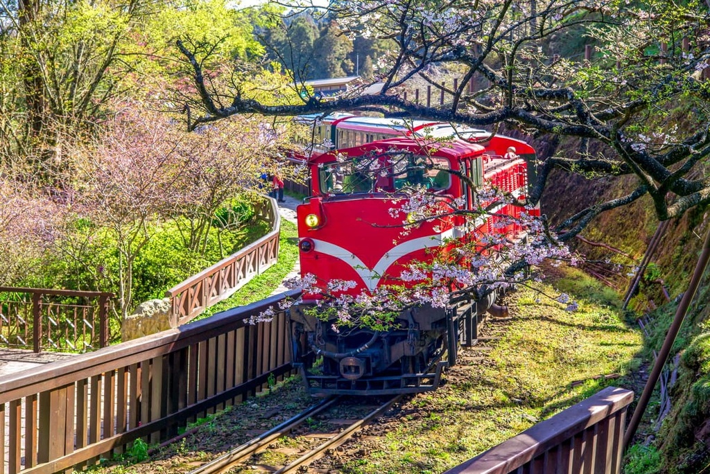
Alishan was once a logging base due to its abundance of cypress trees. The Japanese constructed the Alishan Forest Railway to transport the felled logs from the high mountains of Alishan to the city of Chiayi (嘉義市), with frequent stops along the way. Riding the Alishan Forest Railway through the forest garners incredible views of the dense misty woods.
Another attraction of Alishan is the cluster of massive cypress trees. The Giant Tree Trail is home to 41 Taiwan red cypress, the tallest of which is the 2,300-year-old Xianglin Sacred Tree, which is 45 metres (148 ft) tall and has a circumference of 123 metres (404 ft).
Finally, Alishan's sunrises and sunsets are renowned for their magical streak of warm golden hues that slowly infuse across the broad sky. There are numerous places to see these sunrises and sunsets in the region.
In particular, Zhushan Sunrise Trail leads visitors to the observation deck on Zhushan (祝山). Meanwhile, near Ciyun Temple, there is a platform where visitors can witness twilight’s creation.
Another one of Taiwan's prime attractions is the emerald body of freshwater known as Sun Moon Lake. The scenery of Sun Moon Lake is unparalleled, with its calm turquoise waters and a thin veil of mist suspending over the glasslike surface. A string of luminescent Chinese lanterns hangs over the lagoon's edge while blue mountains encircle the lake.
A 33 km (20 mi) long wooden boardwalk surrounds the lake. It offers great opportunities for walking and cycling. The still quietness of Sun Moon Lake’s remoteness adds to the boardwalk’s mesmerising ambience.

The Sun Moon Lake Ropeway transports visitors through the mountains to the Formosan Aboriginal Culture Village, a theme park offering both entertainment and education. Visitors can stroll through forest pathways, too, all of which showcase sculptures, relics, and traditional performances of Taiwan's Indigenous communities.
Xinyi Township is where many of the trails in Yushan National Park begin. One of Xinyi’s perks is the variety of hot spring facilities in its immediate vicinity. Soaking one’s tired and battered feet in these hot springs after a lengthy and arduous hike in Xiuguping Special Scenic Area or Yushan National Park is an excellent way to reward one’s efforts.

Springtime is exceptionally beautiful in Xinyi as cherry blossoms add a romantic setting to the landscape. With Yushan and numerous other Baiyue situated nearby, the drama of the mountains heightens the region’s scenic beauty.
Visitors can take the Taiwan High-Speed Rail (HSR) to Chiayi from Taiwan’s major cities, such as Taipei, Taoyuan, Hsinchu, Miaoli, Taichung, Tainan, and Kaohsiung. Then, you can hire a car or scooter from Chiayi or board a bus to Xiuguping Special Scenic Area. The distance from Chiayi to Xiuguping Special Scenic Area is 109 km (68 mi).
From Chiayi, the 7322 bus heads to Alishan. In Alishan, visitors must change to the 6739 bus heading to Sun Moon Lake. Visitors can then alight at the bus stop in Dongpu Village, the starting point of the trails in Xiuguping Special Scenic Area.


The highest peak in Xiuguping Special Scenic Area is Xiuguluan Shan, at 3,860 m.
Notable peaks in Xiuguping Special Scenic Area include Xiuguluan Shan and Dasuiku Shan.


