Scan the QR code and open PeakVisor on your phone
Hualien County (花蓮縣) is a land of sprawling giant hills, steep, narrow gorges, and coastal cliffs that meet the expansive Pacific Ocean on Taiwan’s east coast. Hualien County holds 488 named peaks, the highest being Xiuguluan Shan (秀姑巒山) at 3,860 meters (12,664 ft). Malaoloushan (蔴荖漏山) is the most prominent peak measuring 1,684 meters (5,525 ft).
Eastern Taiwan’s Hualien County lies in an area less-connected than Taiwan’s west coast. While the west has multiple railways and roads spanning the coast, few roads connect the west from the east. Taiwan’s tallest hills spread like a spine across the island’s center. The mountains are so rugged and high that they are an obstacle between the opposite coasts.
One of the advantages of being less connected to Taiwan’s major cities is that Hualien has pristine and untouched nature. It is Taiwan’s largest county by land area at 462,800 ha (1,143,604 ac) but is one of the least populated at 350,000. It is bordered by Yilan County (宜蘭縣) in the north and Taitung County (臺東縣) in the south. To the west, Taichung City (臺中市), Nantou County (南投縣), and Kaohsiung City (高雄市) border this eastern Taiwan region.

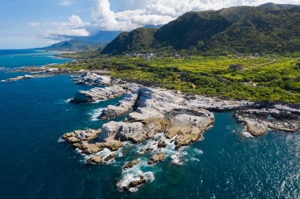
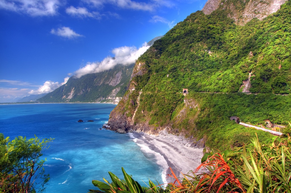
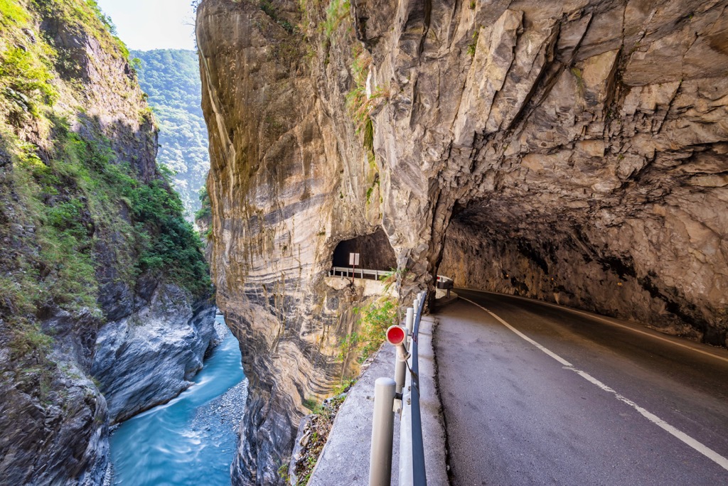
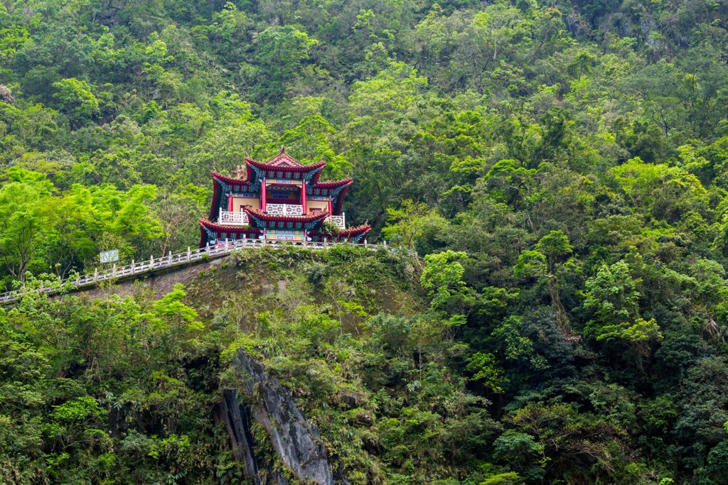
Although it is one of Taiwan’s sparsely populated counties, it holds one of Taiwan’s top natural attractions, Tarako Gorge. Many tourists head to Hualien City (花蓮市) to visit Taroko National Park (太魯閣國家公園), where steep marble canyons rise vertically above the sapphire Liwu River.
Many of Taiwan’s tallest peaks lie in Hualien’s western region. These are Nanhudashan (南湖大山), Qilai Shan (奇萊山), Zhongyang Jianshan (中央尖山), and Wuming Shan (無名山). In fact, 37 of Taiwan’s 100 tallest peaks (also known as Baiyue) lie in Hualien County. While some belong to Taroko National Park, others, like Xiuguluan Shan, Maxi Shan (馬錫山), and Xinkang Shan (新康山), are part of Yushan National Park (玉山國家公園).
Weatherwise, Hualien County has a yearly daily mean of 75°F (23.7°C). Much like the rest of Taiwan, it enjoys a humid subtropical climate. Being on Taiwan’s east coast, Hualien, like Taitung, is the first to be hit by summertime typhoons and the northeast monsoon. This can cause significant damage to land as the storms ravage the coastal land before slowing their path.
There are many notable and well-known attractions in Hualien County. Taroko National Park is in the north, and Yushan National Park is in the south. To the east are the Huadong Valley and Huadong Coastal Reserve (花東沿海保護區). Nenggao Shan (能高山) and its peaks mark the western border.
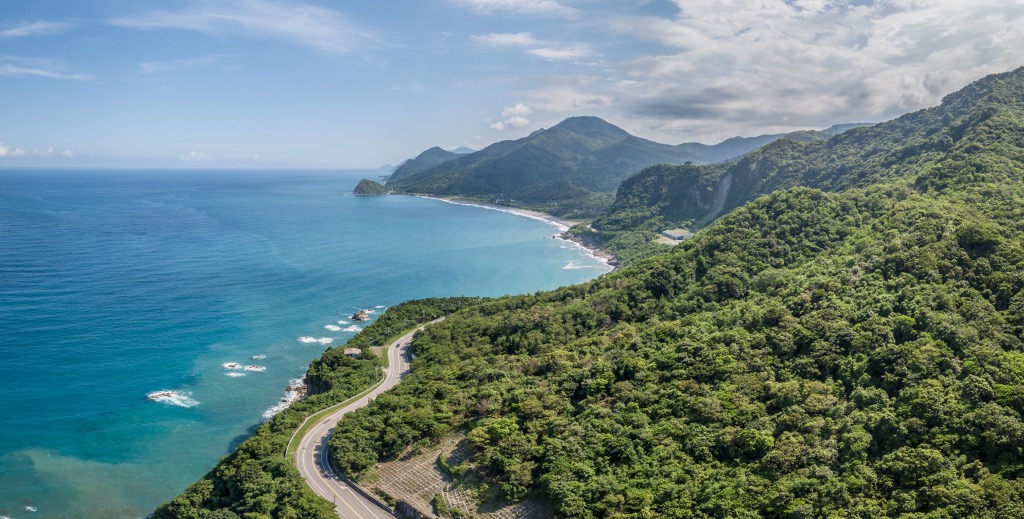
As Hualien County is a large region, it has many hills. Two mountain ranges span its area. These are the Central Mountain Range (中央山脈), Taiwan’s longest massif, and the Hai’an Range (海岸山脈).
The Central Mountain Range is a 270 km (168 mi) long sierra holding Taiwan’s most jagged and towering peaks. These mountains are sturdy, strong, and large, with the rock strata a mixture of dolomite, limestone, sand, and sedimentary rocks from the Mesozoic and Paleozoic epochs.
The Hai’an Range runs along Hualien’s east coast and has gentler, more shallow hills. Once an underwater area, this hill comprises Miocene volcanic base. Clastic deposits from the western Central Moutain Range form a sedimentary layer over the hill’s inner rock.

Hualien County resembles a mini ecosystem of the entire Taiwan island as it has mammoth peaks, valleys, low-lying areas, and a coast. There is a cold temperate forest of fir, juniper, hemlock, and pine on Hualien's highest mountains, from 2,500 to 3,000 meters (8,202 to 9,843 ft). Below 2,500 meters (8,202 ft) is a mix of conifers and broadleaf arboreals, such as oak, spruce, and cypress trees.
In the lower areas, like in Fuyuan National Forest Recreation Area (富源國家森林遊樂區), are flourishing deciduous forests. Fuyuan Forest holds Taiwan's largest camphor woodlands of 70 ha (173 ac). Other common trees that grow in these flat regions are banyan trees, Taiwan crepe myrtle, and rhododendron.
Then along Hualien's shores, coastal and marine plants thrive, such as saddle vine and the tung tree's moss growing on large boulders. In the sea, wide varieties of seaweed and cucumbers occupy the Pacific Ocean's shallow waters.
Human existence in Hualien County dates to 30,000 years ago, from the stone age relics at Baxiandong (八仙洞). Archaeologists uncovered hunting tools and weaponry carved from bones in this prehistoric site.
Ancestrally, Hualien County is home to the Amis tribe. They mostly live between Hualien and Taitung in the Huadong Valley and Coastal Reserve. The Truku tribe also inhabit Hualien’s lands. However, they ventured across Shei-Pa National Park’s (雪霸國家公園) hills to settle in the Liwu River Valley.
The Amis and Truku people have fascinating cultures that add color to Hualien. The Amis are Taiwan’s largest tribe at 200,000 people. They believe that we should honour the spirit in every living thing, from which their annual celebration of the Harvest Festival stems. During July or August, the Ami celebrate through animated dances and songs, worshipping nature, the divine living thing amongst us all.
The Truku tribe are artisans known for their skilful weaving, farming, carving, and sewing. Their traditional garments are beautifully made, with precision and an eye for artistry. Truku people wear their colorful attire pridefully, as all admire the intricate weaving. They also use slash-and-burn farming techniques to grow sweet potatoes, corn, and millet.
Hualien County has an amplitude of hiking trails in its vast region of hills and valleys. The major hiking trails and areas are:
One of Taroko National Park’s most iconic sites is the Eternal Shrine. Set amongst a verdant forest of leafy foliage, the Eternal Shrine sits above a waterfall flowing into the turquoise Liwu River.
Another reason for the trail’s popularity is the short distance of 1.5 km (0.9 mi). Within 300 meters (984 ft) of starting the route, you’ll uncover the majestic sighting of the Eternal Shrine. The picturesque altar is a memorial for the 226 construction workers who did not survive building the Central Cross-Island Highway.
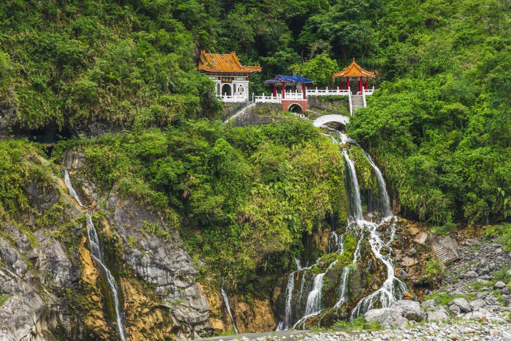
Once you’ve marveled at the ornate temple, you’ll climb a steep staircase to Kuanyin Cave, from where you can overlook the entrance to the park. Take a few more steps towards the Bell Tower, where three rings will grant you a wish. Admire the unrivaled views from the trail’s highest point of narrow marble gorges and cliffs.
For a lengthy and extensive hike, trek the nearly 23 km (14 mi) route of Nanhu's peaks. Upon your journey, you'll summit four mountains. These peaks are all Baiyue, belonging to Taiwan's tallest 100 hills. They are Shenmazhen Shan (審馬陣山), Nanhu Beishan (南湖北山), Nanhu Dashan (南湖大山), and Nanhu Dashan East Peak (南湖大山中南峰).
Situated in Nanhu Ecological Reserve (南湖中央尖山群生態保護區), this trail's flora is rich and diverse. You'll encounter unique plants such as the Nanhu willow leaf, Nanhu rhododendron, Nanhu mountain orchid, and catclaw buttercup, all native to this area.
It will take two days to reach Shenmazhen Shan and Nanhu Beishan. Start your day early, as it's a continuous uphill slog to Shenmazhen Shan. Take in the incredible view of the surrounding jagged peaks, and view Xueshan's snow-capped pinnacle to the west. You'll also see Zhongyang Jianshan in the south.
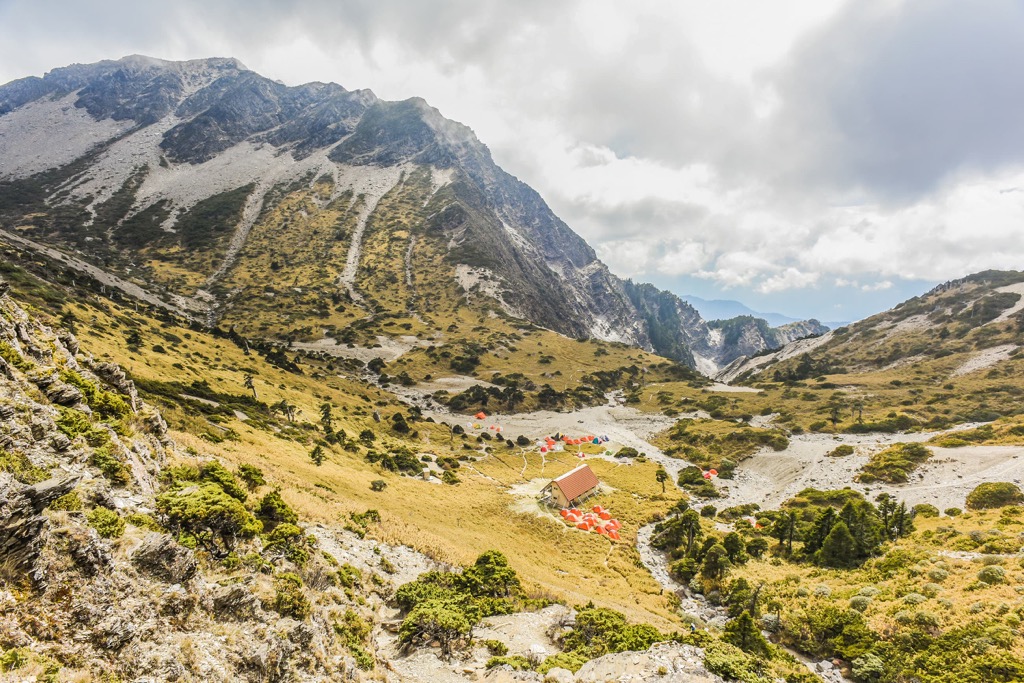
Nanhu Beishan is an additional four-hour trek and is the northernmost Baiyue of the Central Mountain Range. You'll have a different vantage point of the encircling hills from this colossal peak. Also, the oncoming mountains of Nanhu Dashan and Nanhu Dashan East Peak are much closer. You can also note the Holy Ridge that connects Xueshan (雪山) and Dabajianshan (大霸尖山) in neighboring Shei-Pa National Park.
The following morning, you'll witness the glorious sunrise spread over the hilly landscape on Nanhu Dashan's summit. As daylight shines over the mountain, you'll notice the endemic Nanhu rhododendron and Nanhu mountain orchid amongst the flora. Nanhu Dashan East Peak is a further two-hour trek, from where you'll observe hollowed craters formed by glacial activity.
For a fresh dose of phytoncide, go forest bathing in the Fuyuan forest. Broadleaf trees release a wooden scent that lowers stress and increases clarity. Taiwan’s largest camphor grove lies In the Fuyuan forest, with many other scenic attractions like hot springs and a butterfly valley.
The dense broadleaf woods are the perfect breeding ground for butterflies. Try to spot the 30 species of butterflies fluttering around the evergreen grove, such as the common blue bottle and the common windmill. Between March and May, you’ll also see the fireflies glowing orbs in the dark evening skies.
Wander through the 190-ha (470 ac) evergreen forest and marvel at the luscious leafy landscape. As your cross the river, gaze at the majestic Fuyuan Waterfall flowing over the cliffside, showering boulders and foliage with its foamy spray. Then make your way to Fuyuan’s hot springs for a soak amongst butterflies and the surrounding verdant nature.
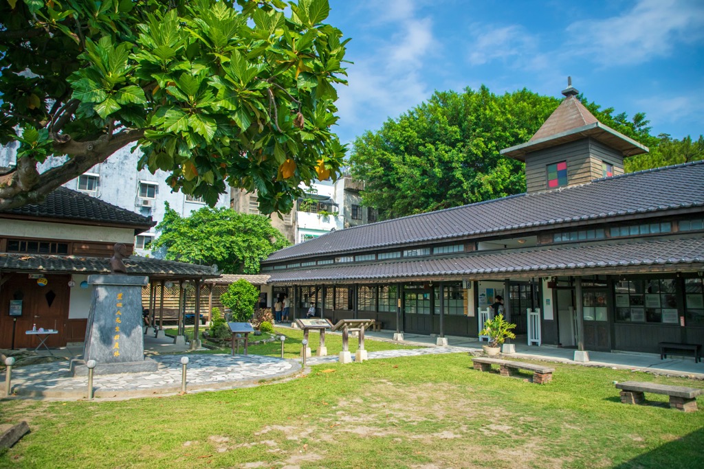
Lintiashan (林田山) has a frozen-in-time logging village where original Japanese structures still stand. The old mountain community is a must-see, as Taiwanese officials have meticulously restored the majestic wooden cypress buildings.
Nestled in the valley of the Central Mountain Range is Lintian Mountain Forestry Centre (林田山林業文化園區). The scenery is beautiful, with a dramatic landscape of imposing grand mountains. Revel in the peaceful setting where only 150 people live. In its heyday, Lintian Mountain village once had 2,000 residents, mostly Japanese.
Admire the abandoned Zhongshan Hall, disused rail tracks and old train carriages. Once the hive of activity, Zhongshan Hall used to show films and host social gatherings. Its entire structure, from the outer shell to the interior decoration, is made of wood. Neat wooden planks line the walls, and cypress timber covers the floor. Slats of wood support the panelled roof, and the stage, chairs, and tables are cypress.
Follow the winding mountain railroads that once carried felled logs to Hualien. You'll see spectacular views of low-lying forests and shaded valleys along the trail. You'll also witness the stunning surrounding mountains of Pinglinshan (平林山), Xiangshan (向山), and Xifenglinshan (西鳳林山).
Travel the old railroad across the mountain and be rewarded with refreshing forest tones of emerald and lime. You'll see discarded train carriages on the way, perfect for history buffs. You can observe the appearance and interior of the train, admiring its retro design.
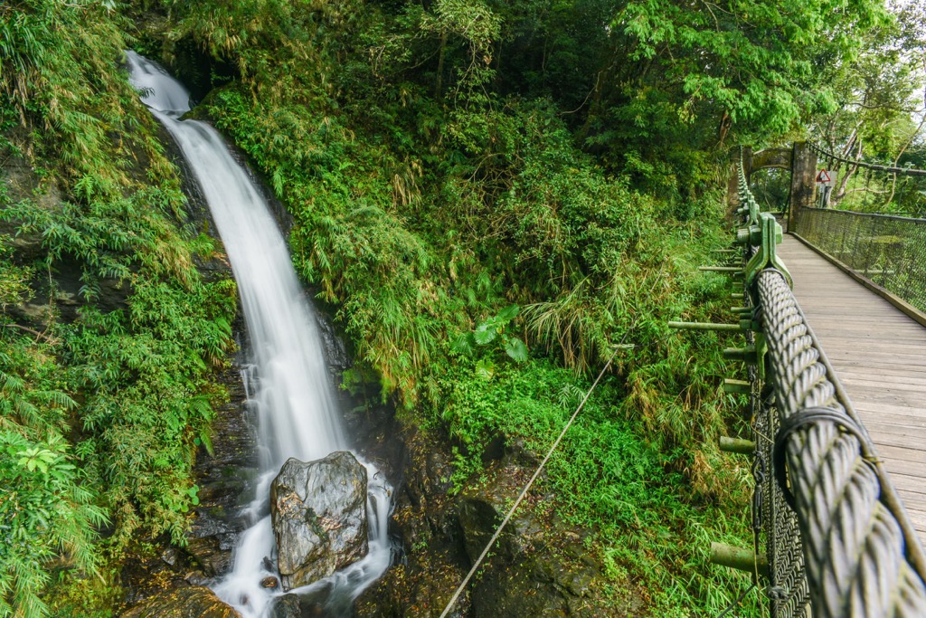
Forming the eastern section of the Batongguan Yueling Road, the Walami Trail (瓦拉米步道) spans 14 km (8.6 mi) from Shangfeng to Walami. This route features a majestic three-layered waterfall, tropical forests featuring many ferns, and relics from the Japanese Occupation Era, such as abandoned police stations.
The trailhead is off Highway 30, where you'll begin the westward path. A shy 1.7 km (1 mi) later, the masterpiece of Shanfeng Waterfall (山風瀑布) announces its picturesque presence with roaring rapids as white-water sheets fly down the cliff. For the best view, head to the 30-meter (98 ft) high suspension bridge, where the third and lowest layer of the waterfall spills into a turquoise pool as the droplets of condensation spray in all directions.
After Shangfeng Waterfall, set off towards Jiashin, where you'll approach the first old Japanese police building on the Walami Hiking Trail. Due to its high elevation, Jiashin offers exceptional views of the peaks of Yuli Shan (玉里山), Zhuoxi Shan (卓溪山), and Huangma Shan (黄麻山).
An evergreen path will lead you into an emerald world of camphor trees, feathery ferns, and velvety moss. The Huangma Valley appears at the end of the 5km (3 mi) green pathway, with the gushing stream of the Lakulaku River (樂庫樂庫溪) flowing furiously nearby.
You'll find yourself at the trail's the halfway point heading further onwards. A suspension bridge near Walami Mountain House is exceptionally scenic as the Lakulaku River flows eastwards towards Huangma Valley. Two sheer cliffs frame the suspension bridge in the valley below. You'll then retrace the route back to the starting point at Shangfeng.
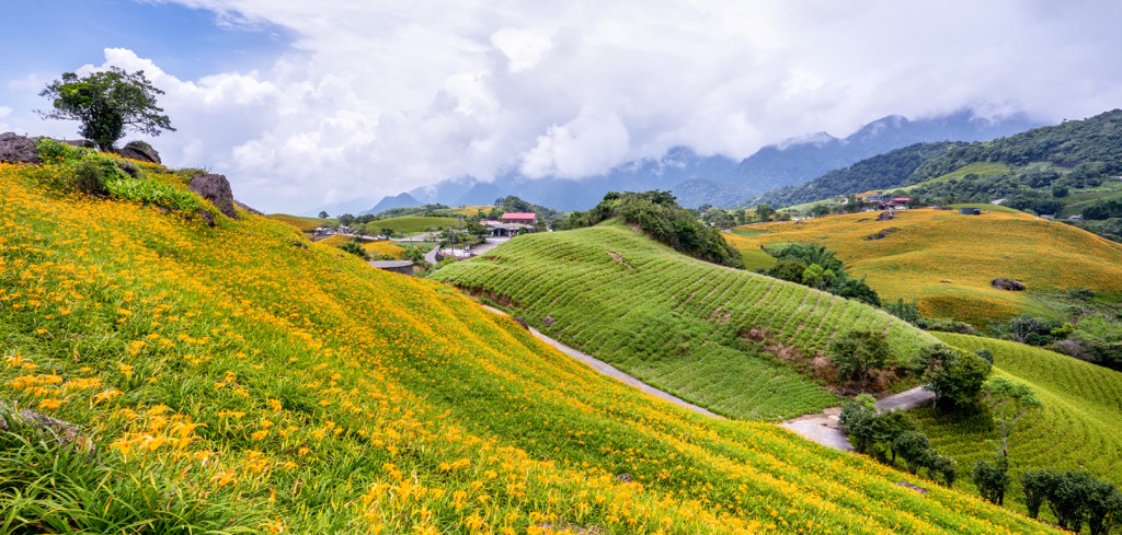
Unlike the colossal peaks of the Central Mountain Range, Liushishishan (六十石山) belongs to the small Hai’an Range that runs along the coast in the Huadong Coastal Reserve. It is only a 3 km (1.8 mi) trek to Liushishishan’s summit, a short journey to the top to admire breathtaking scenery.
The best months to climb Liushishishan is in August and September when sunlit meadows of daylilies bloom across the rolling fields. There are many observation points along the hill from where you can admire the landscape of undulating emerald hills and the azure sea of the Pacific Ocean.

At the highest point, you can observe the surrounding hills of Antuku Shan (安土堀山), Chengguangao Shan, and Wanrenshan (萬人山) and gaze over the Huadong Valley. Suppose you’re climbing Liushishishan in the afternoon. In that case, foggy sea mists roll over the gentle terrain, creating a mesmerizing sight as it hugs the low-lying hills.
When visiting Hualien County, most people stay in Hualien City, the gateway to Taroko National Park. Ruisui Township is another beautiful spot to stay in the heart of the Amis folks' land and is close to many scenic locations.
There’s no denying that Hualien City is one of the best cities along Taiwan’s east coast. Laid-back, friendly, and surrounded by turquoise beaches and emerald fields, it's a place that will creep into your heart and stay there forever.
Hualien City has no shortage of magnificent beaches. For a chance to stroll along the seashore and inhale the salty sea air, head to Beibin Beach. Twilight is the best time to admire its beauty, with honey hues infusing the sky that mirrors the sea. After your beach walk, walk through the park to look at the sculpture of Guanyin, the Goddess of Mercy, guarding the sea.
Witness a piece of history as you overlook grand sea views from Pine Garden. Once an old Japanese naval base, kamikaze pilots had sending-off parties in the grand building. Pine Garden’s immaculate manicured lawns are a popular weekend spot when locals want to picnic and gaze onto the blue ocean.
Then follow the tantalizing food trail to Dongdamen Night Market. Hualien’s largest night market sells Taiwanese favourites like coffin bread, stinky tofu, and beef noodle soup. You’ll also find Truku aboriginal dishes here, such as stir-fried wild boar and pork dumplings. You can also shop for clothes, accessories, and electronics and have fun by playing arcade games.

Further down the coast is Ruisui Township. While it's a primarily remote land, visitors are in for a fun surprise when they visit. It is nothing short of entertaining in the stunning, secluded Huadong Valley.
Ride the wild waves of the Xiuguluan River for some white water rafting adventures. The eastward-flowing Xiuguluan River moves fiercely, dropping a total of 65 meters (213 ft) throughout the 24 km (15 mi) course. It's a fascinating journey with many thrills as you hold on and try to stay inside the boat.
After your adrenaline rush, visit Ruisui Hot Springs for a tranquil soak. The sound of chirping insects, tweeting birds, and soft winds replace the sounds of crashing waves. You'll melt into serenity as you unwind in the beautiful outdoors surrounded by ample shades of greenery.
If you're traveling with kids, visit the family-friendly Ruisui Ranch. Although everyone will enjoy the rustic charm of this farmyard. You can observe livestock grazing in the fields and even feed the cows. If you want a refreshment, try the homemade ice cream at the farm shop and stock up on premium dairy products of milk, yogurt, and cheese.
It's best to start your journey from Taipei to get to Hualien City. Take the local express train (TRA) from Taipei Main Station to Hualien City. Alternatively, you can rent a car or scooter and drive from Taipei. The journey is 157 km (98 mi).