Scan the QR code and open PeakVisor on your phone
Home to steep crags, rugged badlands, grassy plains, and a section of the mighty Missouri River, the Upper Missouri River Breaks National Monument is a federally protected area situated in the north-central part of the US state of Montana. The monument contains 29 named high points, the highest of which is Chimney Butte (3,455 ft/1,053 m) and the most prominent of which is The Wall (3,373 ft/1,028 m).
Upper Missouri River Breaks National Monument is a rugged and remote protected area that’s located in the north-central part of the US state of Montana. The monument is situated in Phillips, Blaine, Chouteau, and Fergus counties, just to the northwest of the city of Great Falls.
With a total area of approximately 589 square miles (1,526 sq. km), Upper Missouri River Breaks is actually one of the largest national monuments in the contiguous United States. It is just slightly smaller than Sonoran Desert National Monument in Arizona and Organ Mountains–Desert Peaks National Monument in New Mexico.
The entirety of the Upper Missouri River Breaks National Monument is administered by the Bureau of Land Management (BLM). The BLM also manages the Upper Missouri National Wild and Scenic River, however the adjacent Charles M. Russell National Wildlife Refuge is managed by the US Fish and Wildlife Service.
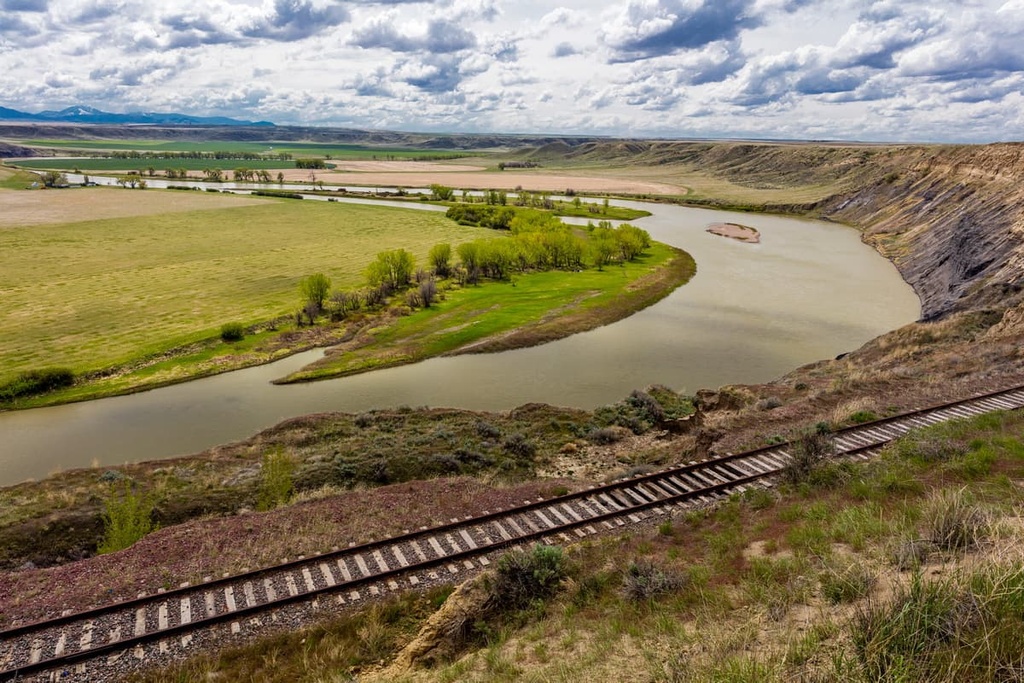
The monument is primarily designed to protect the rugged landscape surrounding the Upper Missouri. It includes land on both sides of a 149 mile (240 km) stretch of the river as well as parts of the Judith River, Antelope Creek, and Arrow Creek.
Technically, there are no federally designated wilderness areas located within the national monument. However, there are currently six wilderness study areas, which are lands that have the characteristics of wilderness but haven’t yet been designated by Congress. These wilderness study areas include:
Besides the Charles M. Russell National Wildlife Refuge, the Upper Missouri River Breaks National Monument is located near a number of other outdoor recreation destinations. These include the Lewis and Clark National Forest and the Helena National Forest to the south and west.
The area in and around the Upper Missouri River Breaks National Monument is a truly geologist's paradise.
The hills in the area aren’t part of any major mountain chain, though the Central Montana Rocky Mountains are located just to the west. That said, the rocks that exist in the national monument formed as a result of sediment deposition when the region was covered by an ancient inland sea about 80 to 70 million years ago.
This ancient sea left behind large deposits of sandstones and shale that we still see to this day. The Missouri River then carved through these layers of rock to create the incredible valley in the national monument.
There are also a number of sizable dikes, which are intrusions of igneous rock. The sedimentary rocks in the area are much more susceptible to erosion, so wind and water have since stripped these dikes of their surrounding sedimentary rocks, leaving behind striking black rocks and other similar features in the region.
Although they aren’t proper mountains, the major high points in the Upper Missouri River Breaks National Monument are Chimney Butte, The Wall, Saskatchewan Butte, Birch Creek Hill, Dark Butte, Reppe Butte, and Black Butte.
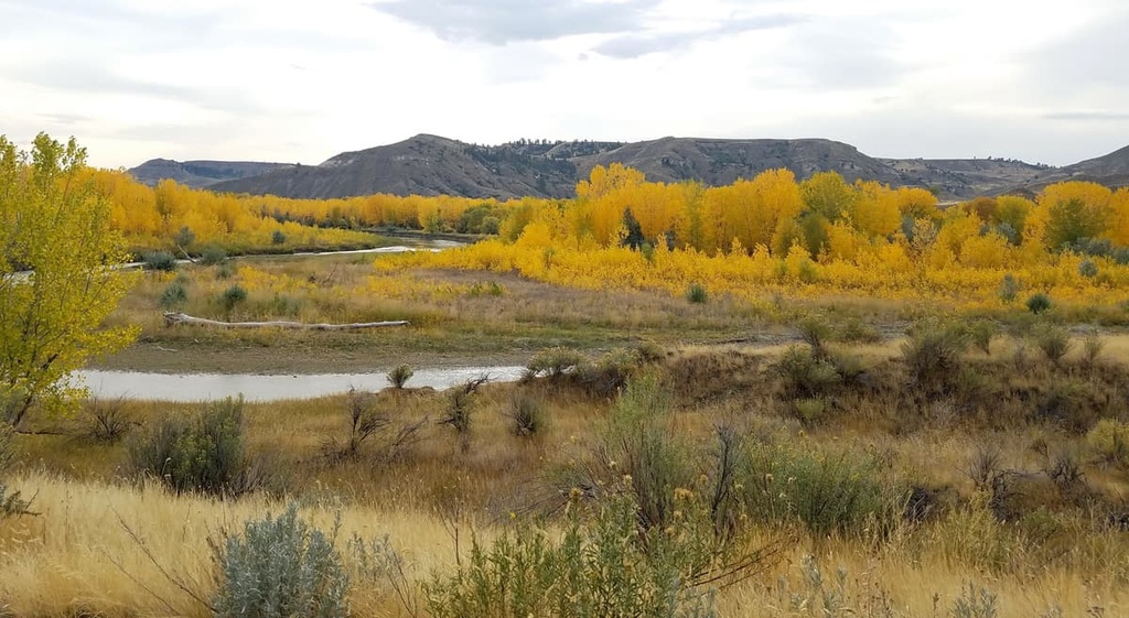
The Upper Missouri River is a hub for biodiversity in central Montana. Within the national monument, the landscape is primarily dominated by a riparian zone, since the monument mostly includes lands that are along the river corridor.
This type of ecosystem is rare in the otherwise arid western US, though it supports stands of cottonwoods, willows, and other low-lying shrubs.
Wildlife is particularly common in the national monument. More than 60 species of mammals, 20 species of amphibians, and 230 species of birds have been identified within the Upper Missouri River Breaks.
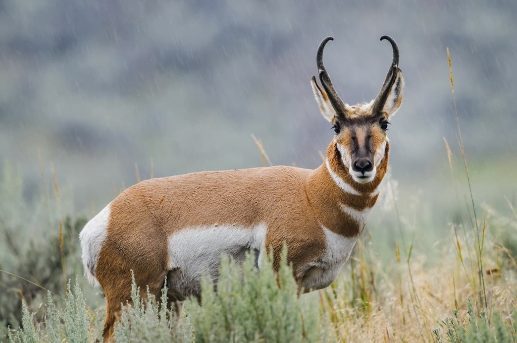
Some of the most common species include pronghorn antelopes, red foxes, coyotes, badgers, racoons, porcupines, muskrats, and beavers. There are also mule deer, mountain lions, white-tailed deer, and Rocky Mountain bighorn sheep, though the latter are mostly found in the neighboring wildlife refuge.
Additionally, the waters of the Upper Missouri are home to approximately 49 species of fish, including goldeye, walleye, northern pike,paddlefish, smallmouth buffalo, carp, channel cat, sauger, and drum.
The land that is now part of the Upper Missouri River Breaks National Monument is part of the traditional territory and ancestral homelands of the Blackfeet Nation, Crow Tribe (Apsáalooke), and the Očhéthi Šakówiŋ (Great Sioux Nation/Seven Council Fires), among other tribal nations.
Some of the first people of European descent to visit the Upper Missouri region were French fur trappers and traders who came to the region in the late 1700s. Soon afterward, members of Lewis and Clark's 1803–1806 expedition also visited the area. The expedition traveled through what is now the monument in May and June of 1805 on their way to the mouth of what is now called the Columbia River.
In the years that followed the Lewis and Clark Expedition, the region became popular among fur trappers. The town of Fort Benton, which is located just upriver of the current national monument, was established in 1846 by a fur trapper by the name of Alexander Culbertson. Fort Benton became a very important river port for fur trappers, miners, and merchants throughout the nineteenth century.
As the fur trade declined in the late 1860s, the town of Fort Benton actually became a US Army outpost. However, most of the traders and settlers in the region disregarded the Blackfeet Nation’s claims to their ancestral homelands. The Blackfeet were eventually forced to leave the Upper Missouri and many tribal members were forced to live on small reservations and reserves in the US and Canada.
In 1877, at the height of the Nez Perce War, many members of the Nez Perce Tribe (Niimíipuu) traveled through the Upper Missouri River Breaks in an attempt to escape to what is now Canada.
However, the Nez Perce fought the US Army at Cow Island on the river in what is known as the Cow Island Skirmish before making their escape to Canada. This ended up being one of the last skirmishes before the larger Battle of Bear Paw, which was the final fight of the Nez Perce War.

The Nez Perce surrendered, ending the battle. Afterward, many members of the Nez Perce Tribe were forced to live in Kansas and what is now Oklahoma. The Nez Perce Tribe now also has a reservation in northern Idaho.
Although nearly 150 years have passed since the Nez Perce War, there has been no major land development at the Upper Missouri River Breaks. The Breaks continue to maintain their rugged character, free from resource extraction or other infrastructure.
The national monument was established through a presidential proclamation in 2001. Most of the land in the current monument was already managed by the federal government, so this designation simply changed how the land was managed.
Upper Missouri River Breaks National Monument is a haven for outdoor recreationalists that want to spend time in a remote part of central Montana.
There are no maintained or established hiking trails in the national monument, however, visitors are allowed to hike wherever they’d like within the monument’s boundaries. Keep in mind that the sandstone cliffs near the river can be quite crumbly, so take care if hiking near them, and be sure to stay far away from any cliff edges.
Instead of hiking, the primary outdoor activity in the national monument is paddling and boating. The section of the Upper Missouri that travels through the monument is a popular river to run for kayakers, canoists, and jet boaters.
The Bureau of Land Management (BLM) allows non-commercial groups of up to 30 people to paddle and camp along the river without a permit.
However, commercial groups and certain groups larger than 20 may need a permit. There are also seasonal restrictions on when you can use a powerboat in the national monument. Contact the regional BLM office for more information.
This section of the Upper Missouri is classified as Class I paddling. That means that the river is generally regarded as easy to paddle and there are no major rapids. However, there may be submerged rocks, tree strainers, and other hazards that you have to keep an eye out for when you paddle.
When floating the Upper Missouri, visitors are allowed to camp either at the developed campgrounds along the river or in dispersed campsites on the river banks. There are three campgrounds in the monument. These include:
All of these campgrounds operate on a first come, first served basis and no reservations are accepted. You will need to pay a nightly camping fee (between $5–$12 per night) at these campgrounds, so bring cash for your trip.
If you don’t want to stay in a campground, you’re allowed to camp anywhere along the river corridor on public land, including on the islands in the river. But, camping on these islands isn’t recommended between April 1 and July 31 due to nesting birds.
There are also a handful of lean-to-style shelters located at the Hole-in-the-Wall and Slaughter River campsites. These shelters are open to the public and are available on a first come, first served basis.
When camping in Upper Missouri River Breaks National Monument, be sure to practice Leave No Trace (LNT) at all times. If you are camping between Fort Benton and the James Kipp Recreation Area, you’re required to use a portable toilet to carry out all solid human waste.
Campfires are also generally allowed, though the BLM may impose fire restrictions based on current weather conditions and wildfire risk levels.
Looking for a place to stay near Upper Missouri River Breaks National Monument? Here are some of the best cities and towns in the region to check out:
The city of Great Falls is located just to the southwest of Upper Missouri River Breaks. It is the third-largest city in the state with a population of over 60,000 people, and it serves as a cultural and commercial hub for central Montana.
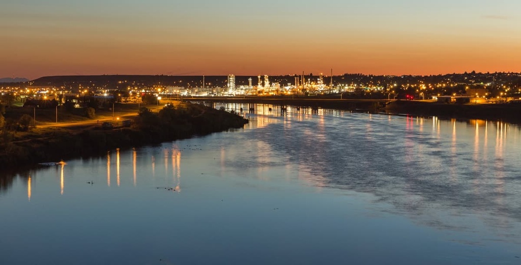
Great Falls is named after its series of 5 waterfalls that are located to the northern and eastern sides of the city. These falls are located on the Upper Missouri, just upriver from the national monument. They posed a serious challenge to the Lewis and Clark Expedition, forcing the expedition to have to make a 10 mile (16 km) portage to continue their journey.
These days, Great Falls is a popular tourist destination in its own right. It is home to a number of excellent museums and it’s just a short drive from a number of major outdoor recreation destinations, including Glacier National Park. The city also has an airport that services flights to Seattle, Las Vegas, Phoenix, Denver, and Salt Lake City.
Fort Benton is a small city of approximately 1,500 residents located just outside the western boundary of the Upper Missouri River Breaks National Monument. Researchers believe that Fort Benton is the second-oldest European-American–established settlement in Montana as it was founded in 1846 by a group of fur traders.
Although Fort Benton is small, it’s a worthwhile place to visit as you head to the national monument. The city is home to a historic district that’s a registered National Historic Landmark. It also has a scenic waterfront area that definitely warrants a visit.

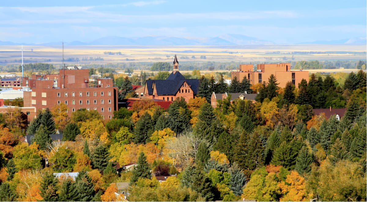
Although it’s located about a 4 hour drive to the south of the national monument, Bozeman is a great place to start any visit to Montana. Bozeman is the fourth-largest city in Montana after Great Falls, but it has the state’s largest airport.
Bozeman is an outdoor recreation destination in its own right, thanks to its proximity to Yellowstone National Park. The city is also home to Montana State University and the Big Sky Ski Resort.