Scan the QR code and open PeakVisor on your phone
The Organ Mountains-Desert Peaks National Monument protects 496,330 acres (200,858 ha) of land in the Mesilla Valley in the southern part of the US state of New Mexico. There are 67 named mountains in the Organ Mountains-Desert Peaks National Monument, the highest and most prominent of which is Organ Needle (8,967 ft/ 2,736 m).
The Organ Mountains-Desert Peaks National Monument protects five mountain ranges surrounding the city of Las Cruces, New Mexico: the Organ Mountains, Doña Ana Mountains, Robledo Mountains, Sierra de las Uvas, and Potrillo Mountains.
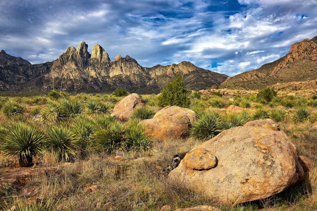
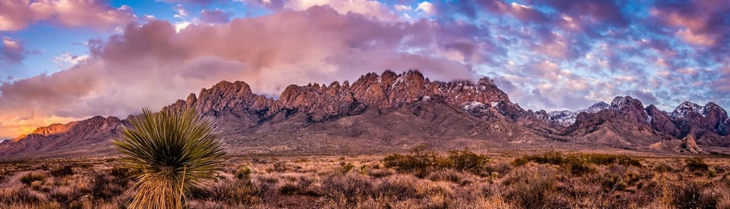
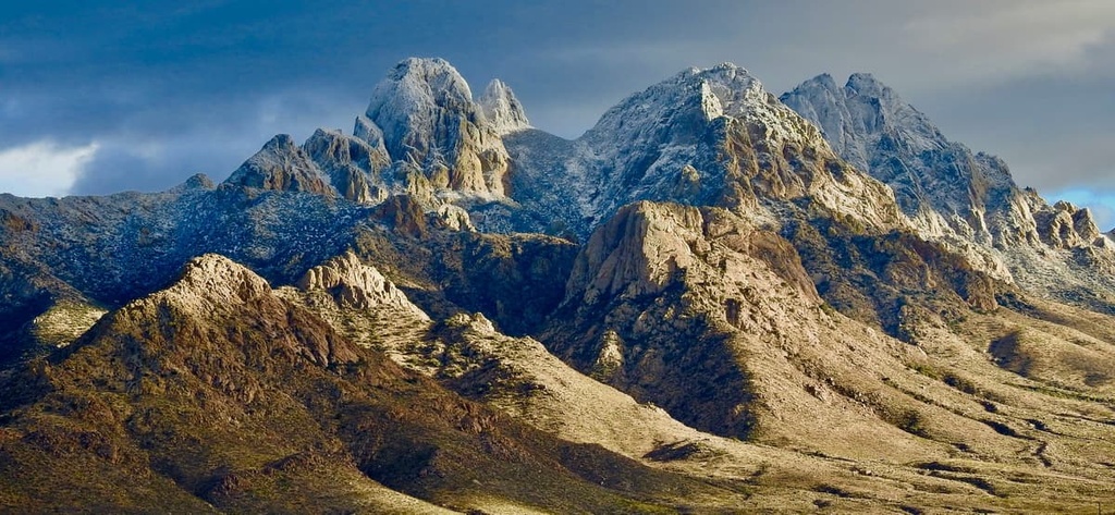
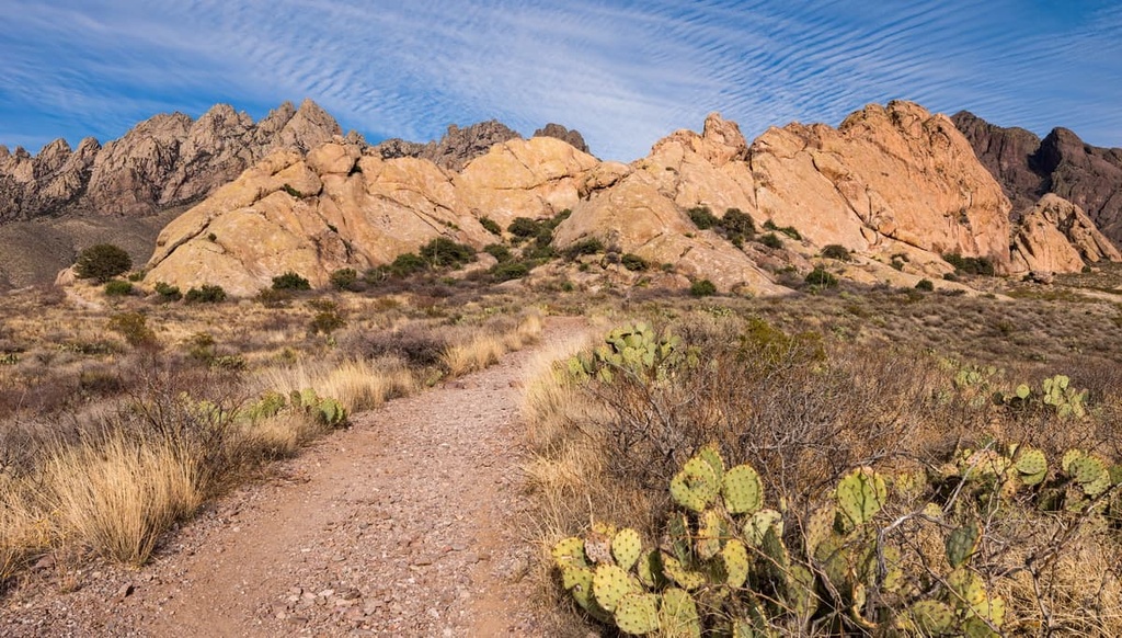
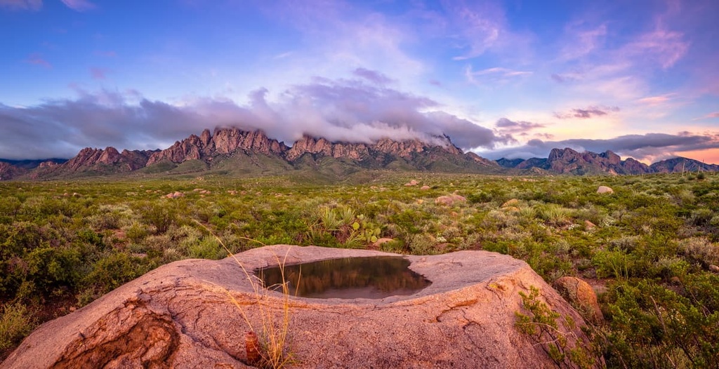
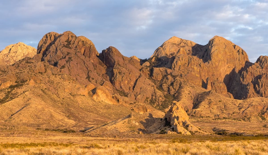
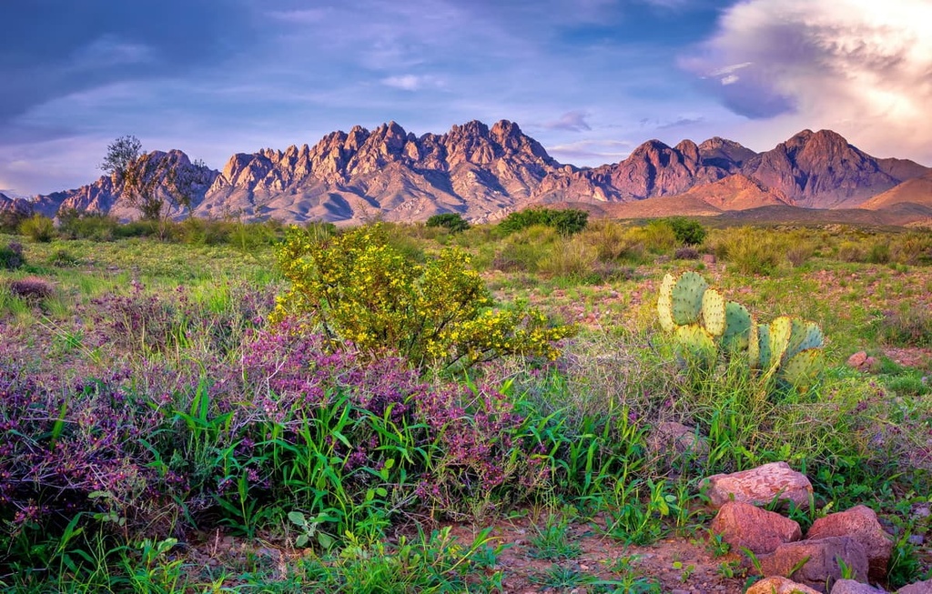
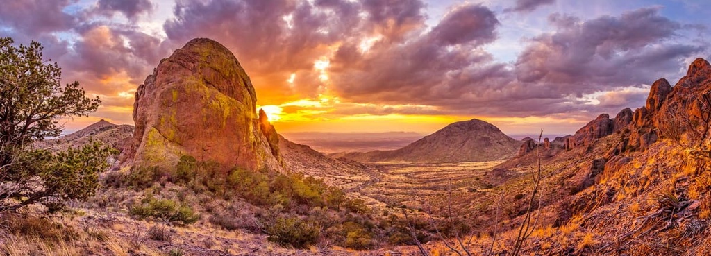
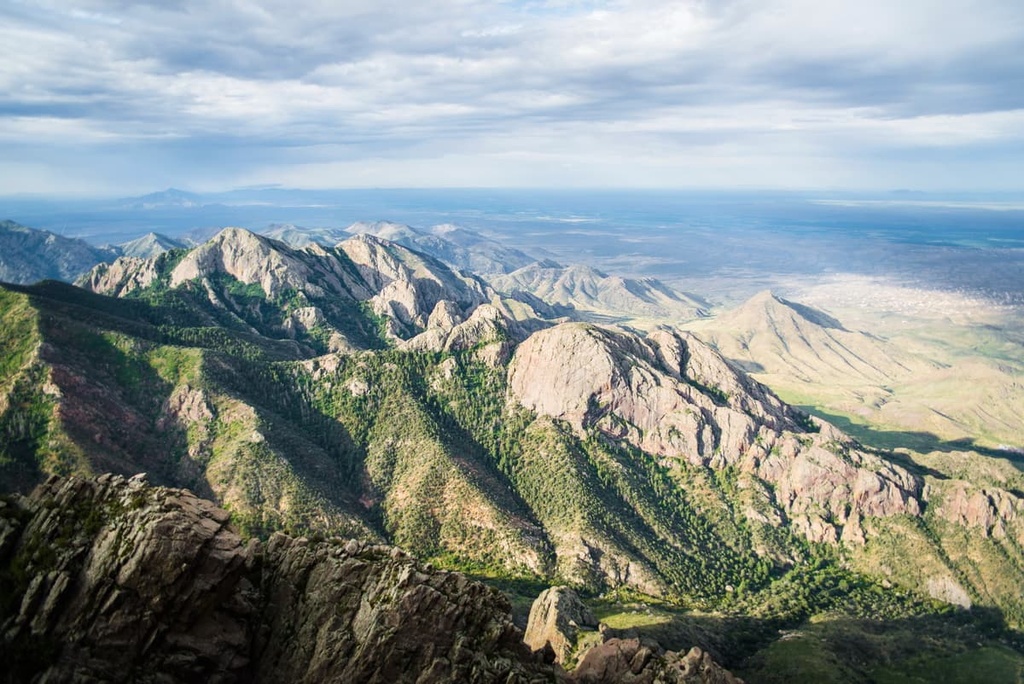
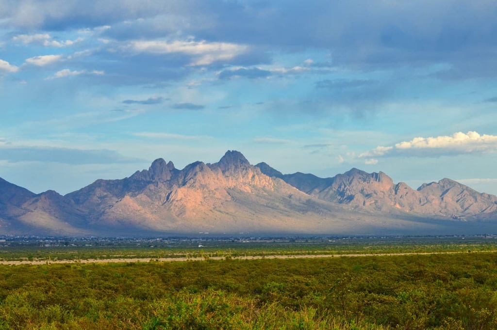
Located 10 miles (16 km) east of Las Cruces, the Organ Mountains are a steep, angular mountain range characterized by craggy granite pinnacles. The range towers nearly 5,000 feet (1,525 m) above the Mesilla Valley and Tularosa Basin, overlooking Las Cruces to the west and White Sands National Monument to the east.
The Organ Mountains are separated from the San Andres Mountains to the north by San Augustin Pass and the Franklin Mountains, to the south, by an area known as Anthony Gap.
Furthermore, the Organ Needle, an 8,976-foot (2,736 m) granite spire, lies at the north end of the range. The southern part of the range contains the Bishop Cap Hills and Rattlesnake Ridge, which more closely resemble the San Andres Mountains and Franklin Mountains.

Together, the Doña Ana Mountains, Robledo Mountains, and Sierra de las Uvas form what is known as the Desert Peaks complex.
The Doña Ana Mountains are an isolated set of peaks that lie to the northwest of the Organ Mountains, roughly 5 miles (8 km) to the north of Las Cruces, New Mexico. The Doña Ana Mountains are characterized by topographic features such as low limestone ridges, hogbacks, and high monzonite peaks.
The range lies along the Rio Grande floodplain and reaches just over 5,800 feet (1,768 m) at its highest points, Doña Ana Peak and Summerford Mountain. Directly to the west of the Doña Ana Mountains, the Robledo Mountains stretch along the west bank of the Rio Grande River.
The Robledo Mountains are home to the Prehistoric Trackways National Monument, which protects a major deposit of Paleozoic era fossilized footprint megatrackways. The north-south trending range contains elevations ranging from about 4,100 feet (1,250 m) to over 5,800 feet (1,768 m) at the summit of Robledo Mountain.
The Sierra de las Uvas, or Grape Mountains, are the westernmost of the Desert Peaks ranges. This red-tinted, volcanic range formed over 10 million years ago. Elevations in the Sierra de las Uvas vary from 5,000 feet (1,525 m) to 6,634 feet (2,022 m) at the summit of Magdalena Peak.
Situated to the south of the Desert Peaks complex, the Potrillo Mountains occupy a remote, southwestern section of the Organ Mountains-Desert Peaks National Monument. The Potrillo Mountains are often subdivided into two parts: the west Potrillo Mountains and east Potrillo Mountains.
The west Potrillo Mountains occupy the western part of the Potrillo volcanic field in the Potrillo Mountains Wilderness. They contain a variety of remarkable volcanic features, including cinder cones, sand dunes, maar craters, lava flows, and an inactive shield volcano called Aden Crater.
The east Potrillo Mountains lie within the East Potrillo Mountains Wilderness, which is located to the southeast of two prominent volcanic domes: Mount Riley and Cox Peak.
The long and narrow east Potrillo Mountains extend to just 5 miles (8 km) north of the Mexico border in south-central Doña Ana County, New Mexico. This set of peaks receives far fewer visitors than the west Potrillo Mountains due to its rugged topography and lack of water or shade.
The Organ Mountains-Desert Peaks National Monument contains three areas of critical environmental concern (ACECs), which require special management to protect important cultural, historical, and natural resources. The three ACECs in the Organ Mountains-Desert Peaks National Monument include:
About 241,000 acres (97,529 ha) of the Organ Mountains-Desert Peaks National Monument is also designated wilderness. These wilderness areas include:
Each of the monument’s five mountain regions provides unique evidence of the area’s extensive geologic history.
Approximately 500 to 250 million years ago, during the Paleozoic Era, limestone and dolomite, interbedded shale, sandstone, and conglomerate were deposited across southern New Mexico in shallow seas. The Bishop Cap Hills, at the southern end of the Organ Mountains, consists of rocks deposited during this time.
Millions of years later, during the Laramide orogeny, old Precambrian granite and Paleozoic rocks were thrust upward into folds and fault-bounded blocks. The Bishop Cap Hills and Rattlesnake Ridge consist of fault-block limestone like that found in the nearby San Andres Mountains and Franklin Mountains.
Most of the spectacular rock formations found in the Organ Mountains today, however, formed 36 million years ago during the Eocene epoch. During this period, magma erupted several times from the Organ caldera volcano. As magma was forced to the surface, large quantities of ash, rock, and lava were dispersed over the landscape.
Magma that didn’t reach the surface cooled slowly to form the Organ batholiths. The most prominent feature of the Organ Mountains, The Needles, provides outstanding evidence of this process. The Needles are composed of light gray Tertiary granite that protrudes nearly a mile above the Tularosa Basin and Rio Grande Valley.
The Organ Mountains have an extensive mining history. The region is rich in minerals like lead, zinc, copper, silver, gold, and fluorspar. Currently, there are five inactive mines in the Organ Mountains: Poor Man's Mine, Torpedo Mine, Ruby Mine, and Stephenson-Bennett Mine.
The Robledo Mountains are an isolated limestone mountain range that many scientists believe formed from the accumulation of sediment deposits from an ancient, shallow sea. The range is characterized by uplifted blocks, rugged, steep canyons, dramatic limestone peaks, volcanic cliffs, and southward dipping escarpments.
Most notably, the Robledo Mountains are home to the Prehistoric Trackways National Monument, which preserves rocks from the Permian period of the Late Paleozoic era. These rocks contain major deposits of 280-million-year-old, fossilized footprints made by amphibians, reptiles, insects, and crustaceans, as well as plants and petrified wood.
The Robledo Mountains are also home to a variety of limestone caves. One of the most famous features in this region is Geronimo’s Cave, where the famed Apache leader, Geronimo, is said to have hid to evade US soldiers.
Meanwhile, to the northeast of the Robledo Mountains, the Doña Ana Mountains are a westward-tilted fault block range shaped by volcanism, tilting, and erosion. Generally, the range is divided into three physiographic sections: the northern, central, and southern Doña Anas.
A group of high monzonite peaks, including Summerford Mountain, tower over low limestone ridges, hogbacks, and cuestas in the northern Doña Ana Mountains. The central portion of the range, between Wagner Canyon and the Red Hills-Dagger Flat area, is characterized by low, rounded hills composed of strata from the Eocene epoch.
The southern third of the range is formed largely from Oligocene intrusive rocks and ash-flow. This part of the range houses several impressive, pyramidal peaks of monzonite porphyry, including Doña Ana Peak.
The northernmost of the Desert Peaks, the Sierra de las Uvas Mountains, are a low, volcanic range that formed over 10 million years ago. The Sierra de las Uvas Mountains formed through a domed uplift fault of Cretaceous and Tertiary age. They consist of tilted beds of volcanic rock. Magdalena Peak, the highest point in the range, is a lava dome that rises over 6,500 feet (1,981 m) above sea level.
The Potrillo Mountains region provides extensive evidence of the region’s violent geologic history of seismicity and volcanism.
Located within the Potrillo volcanic field, the west Potrillo Mountains boast hundreds of volcanic features, including maars, spatter cones, a shield volcano, and cinder cones. Strata that date back from the Paleozoic to the Holocene are exposed here.
One of the most fascinating features in the west Potrillo Mountains is Kilbourne Hole, a volcanic crater that formed when magma interacted with groundwater during an eruption 45,000 years ago.
The east Potrillo Mountains are an uplifted west-tilted fault-block and contain the only Cretaceous-age rocks in the Organ Mountains-Desert Peaks National Monument. The east Potrillo Mountains also contain limestone, dolomites, and silty beds of Middle Permian age.
The Organ Mountains-Desert Peaks National Monument contains a wide variety of vegetative communities, including black grama grasslands, mixed cactus and desert shrubs, montane shrublands with sumac, stands of mountain mahogany, oak, pinyon, and juniper, and small pockets of ponderosa pine forest. These communities sustain a range of animal species.
Natural springs in the Organ Mountains are critically important to wildlife, including mule deer, Montezuma quail, and mountain lions. Golden eagles, red-tailed hawks, and the endangered Aplomadon falcon are also known to travel above the area’s grasslands and foothills, where they prey on mice, rock squirrels, and other rodents.
Several special-status plants and animal species flourish in the Organ Mountains, including four species of endemic mollusks, a population of Colorado chipmunk, and five endemic plant species.
Plant communities found in the Desert Peaks region can be generally characterized as Chihuahuan desert scrublands, creosote bush desert, and desert grasslands. In the volcanic Sierra de las Uvas and Portillo Mountains, desert grasslands sustain thriving populations of quail, mule deer, coyote, black-tailed jackrabbit, and other wildlife.
Juniper woodland, juniper savannah, and montane shrubs, including mountain mahogany, shrub live oak, and sumac can be found in higher elevations. The abundance of cliffs in the region provides nesting and perching sites for raptors, including bald and golden eagles, various hawks and owls, and the Federal-endangered peregrine falcon.
Even in the east Potrillo Mountains, where a lack of precipitation and permanent water imposes harsh demands on ecological communities, a variety of plant communities thrive. During summer monsoons, an array of wildflowers pop up in the area. Isolated clusters of netleaf hackberry and other desert trees also thrive in lava flow where deep pockets of soil hold extra water after rainfall.
Long before the arrival of Europeans to the southwest, the present-day Organ Mountains-Desert Peaks National Monument was occupied by numerous Indigenous communities.
Archeological evidence located in the Robledo Mountains and Potrillo Mountains suggests people of the Paleo-Indian culture occupied the area 8,000 to 12,000 years ago. Hundreds of artifacts belonging to the Desert Archaic peoples and their descendents, which include the Mimbres Pueblo, Jornada Mongollon, and the Apache, have also been uncovered in the area.
Spanish conquistadors and colonizers were the first Europeans to arrive to the Organ Mountains-Desert Peaks National Monument area. They named the region’s prominent spires the Sierra de los Órganos, or Organ Mountains, due to their resemblance to organ pipes.
Throughout the 1800s, the Organ Mountains-Desert Peaks area was central to conflicts between the Apache, Spain, Mexico, and the US.
From 1846 to 1848, the Robledo Mountains, Sierra de las Uvas, and Doña Ana Mountains were at the center of intense territorial disputes during the Mexican American War. Immediately after the Mexican American War, the Robledo Mountains and Sierra de las Uvas Mountains saw years of violent attacks between the United States Army and various Apache Tribal Nations in what is known as the Apache Wars.
Today, remnants of Apache conflict sites, including a famed hideout used by Geronimo, a legendary Apache warrior, and a US army heliograph communication station on Lookout Peak, are accessible to visitors.
In the 1860s, the first US Civil War engagements in New Mexico were also fought in the Organ Mountains, when confederate soldiers used Baylor Pass trail to outflank Union soldiers. Today, the Baylor Trail remains the only maintained trail that traverses the Organ Mountains.
Throughout the nineteenth century, traders, soldiers, merchants, and travelers continued to use routes first established by Tribal Nations in order to colonize the Rio Grande Valley. Today, the 1,590-mile (2,560-km) El Camino Real de Tierra Adentro National Historic Trail honors this impressive network of footpaths.
Many historic sites that date back to the early periods of European colonization and settlement are also well-preserved in the Organ Mountains-Desert Peaks National Monument.
This includes rock cairns that mark the boundary of the Gadsden Purchase, a shallow cave once used as a hideout by Billy the Kid, Depression-era dams, and aircraft training targets used during World War II.
The Organ Mountains-Desert Peaks National Monument is home to unique wilderness areas and hundreds of fascinating cultural and historical landmarks. If you’re planning a trip to the monument, these are some of the best sites and attractions to check out:
These are some of the most scenic hiking trails and attractions in the Organ Mountains region:
Dripping Springs Natural Area
Located in the western foothills of the Organ Mountains, the Dripping Springs Natural Area contains over 4 miles (6 km) of hiking trails, many of which highlight the region’s expansive desert scrub and low-elevation pinion-juniper and oak woodlands. The most popular trail in the area is the Dripping Springs Trail, a 1.5-mile (2.4 km) footpath that features the historic Van Patten Mountain Camp.
Soledad Canyon Day Use Area
Located at the junction of Bar Canyon and Soledad Canyon, the Soledad Canyon Day Use Area contains miles of scenic hiking and biking trails. The Bar Canyon trail features scenic views of the central Organ Mountains and southern Mesilla Valley. The 3.3-mile (5.3 km) Soledad Canyon loop is a casual trail that leads to a waterfall.
Sierra Vista Trail
The 29-mile (47 km) Sierra Vista trail runs along the western edge of the Organ Mountains. It boasts incredible views of the Rio Grande Valley. The trail is used primarily by mountain bikers, and it connects to the Franklin Mountain State Park trail system in Texas.
Aguirre Springs National Recreation Area
Located at the base of the spectacular Organ Mountains, the Aguirre Springs National Recreation Area is a popular destination for hikers and campers. The Aguirre Springs campground boasts 55 sites overlooking the Tularosa Basin and nearby White Sands National Monument. There are also several miles of trails to explore.
These are some of the most scenic hiking trails and attractions in the Desert Peaks region:
Sierra de las Uvas Wilderness
The Sierra de las Uvas Wilderness protects approximately 11,114 acres (4,498 ha) of land in the Organ Mountains-Desert Peaks National Monument. Several Tribal Nations have left their mark on these volcanic mountains over the course of millennia. At least two petroglyph sites are tucked in the Sierra de las Uvas Wilderness.
Picacho Peak Recreation Area
Picacho Peak is a volcanic mountain composed of 35-million-year-old rhyolite that lies 7 miles (11 km) from downtown Las Cruces, New Mexico. The trail to the summit of Picacho Peak provides sweeping views of the Mesilla Valley and Organ Mountains. Nearby, the recreation area also boasts more than 15 miles (24 km) of mountain biking, hiking, and equestrian trails to explore.
Prehistoric Trackways National Monument
Located in the Robledo Mountains of Doña Ana County, the Prehistoric Trackways National Monument preserves 280-million-year-old wildlife tracks, as well as fossilized fauna and petrified wood from the Permian period. Although access to Trackway fossils is limited, opportunities for hiking and off highway driving are available within the park.
Geronimo’s Cave
A prominent warrior of the Bedonkohe band of the Apache people, Geronimo clashed with and evaded Mexican and US troops many times throughout the course of the Apache Wars. During one such escape, Geronimo is believed to have entered a cave in the Robledo Mountains to elude US troops.
Though US soldiers waited outside of the entrance, he never resurfaced. He was later spotted outside of the cave, but a second entrance was never found. Today, this cave is referred to as Geronimo’s Cave. Today, visitors to the Organ Mountains-Desert Peaks National Monument can visit Geronimo’s Cave via a 2.5-mile (4 km) trail.
Broad Canyon Wilderness
The secluded Broad Canyon Wilderness protects 13,902-acres (5,626 ha) of hidden water pools and ancient cultural sites in the eastern Sierra de las Uvas. The wilderness contains several small canyons that were created by water-eroded lava flows. Several petroglyphs are scattered throughout the area.
These are some of the most scenic hiking trails and attractions in the Potrillo Mountains region:
Aden Lava Flow Wilderness
The Aden Lava Flow Wilderness contains 27,673 acres (11,199 ha) of exceptional volcanic features, including basalt flows, volcanic craters, and coppice sand dunes.
The wilderness is located 20 miles (32 km) southwest of Las Cruces, New Mexico, and is home to Aden Crater, a small shield volcano that is believed to have erupted 16,000 years ago. The Aden Lava Flow Wilderness allows visitors to explore the many fascinating geological wonders of the Potrillo volcanic field.
Kilbourne Hole National Historic Landmark
Located to the south of the Aden Lava Flow Wilderness, the Kilbourne Hole Volcanic Crater stretches for over a mile between the Potrillo Mountains and the Rio Grande.
This 300-foot (91 m) deep volcanic maar crater was once used by Apollo 12–17 astronauts as a model for a lunar environment. Its 40-foot (12 m) basalt cliffs are also said to closely resemble those found at the Devil’s Postpile National Monument in California.
Potrillo Mountains Wilderness
Located just 45 minutes away from El Paso and Las Cruces, the Potrillo Mountains Wilderness protects 105,085 acres (42,526 ha) of land in the western Potrillo volcanic field. The wilderness contains hundreds of volcanic features, including maars, spatter cones, a shield volcano, and cinder cones.
Mount Riley Wilderness
Located between the east and west Potrillo Mountains, Mount Riley rises over 1,700 feet (518 m) above the surrounding Chihuahuan desert, reaching almost 6,000 feet (1,829 m) in elevation.
Though no maintained trails exist within the wilderness, Mount Riley and two nearby isolated peaks, Cox Peak and Point 5872, are dominating features in the region and are a worthy objective for peak baggers exploring the area.
If you’re traveling to the Organ Mountains-Desert Peaks National Monument, here are a few of the nearby cities to check out:
Located at the edge of the Chihuahuan Desert, Las Cruces is the second-largest city in New Mexico. The city is rich in history and is packed with cultural attractions including art galleries, museums, annual festivals, and theaters.
Visitors to Las Cruces can also easily explore over 100 miles (161 km) of scenic hiking and biking trails on 500,000 acres (202,343 ha) of public land. While in the city, you can also check out several nearby parks, including White Sands National Park and the Organ Mountains-Desert Peaks National Monument.
Each year, roughly 30,000 people travel to Hatch, a small community located along the Rio Grande River valley, for the Hatch Chile Festival. Though this small town is renowned for its delicious chiles, it’s also home to a variety of other food and lodging options that are well worth checking out, too.
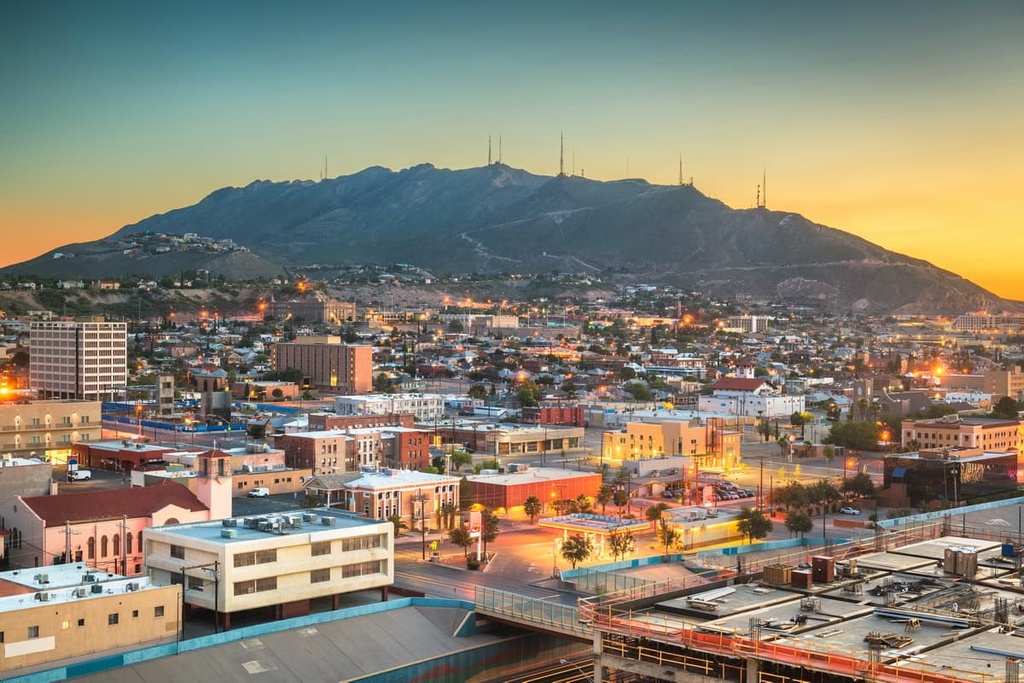
El Paso lies at the far western corner of Texas, directly across the Mexico–US border from Ciudad Juarez, the largest city in Chihuahua. Though El Paso is geographically isolated from other major cities in Texas, it serves as the perfect basecamp for exploring the southwestern US.
Visitors to El Paso can travel to and explore several beautiful parks and recreation areas, including Franklin Mountains State Park, the Organ Mountains-Desert Peaks National Monument, and White Sands National Park.