
Scan the QR code and open PeakVisor on your phone
The remote northern wilderness of British Columbia, Canada contains some true backcountry gems. Centered upon the Rocky Mountain Trench, Dune Za Keyih Provincial Park encompasses the confluences of the Gataga and Frog rivers with the mighty Kechika River. The park also contains 7 named peaks that overlook the region’s river valleys, the tallest of which is Brownie Mountain (2,313 m/7,589 ft).
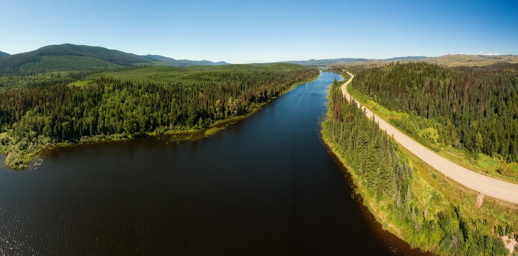
Dune Za Keyih Provincial Park is a remote wilderness park in the Rocky Mountain Trench that encompasses the valleys of the Kechika, Gataga, and Frog rivers in northern British Columbia, Canada. The Gataga River flows to the Kechika from the Rockies while the Frog River flows down from the Cassiar Mountains.
As it is located about 30 km (18 mi) to the south of Highway 97, there is no road access to the park and most visitors arrive via jet boat, float plane, or helicopter. If you arrive at the park by air or river, you will notice the peaks of the Rockies to the east and the Cassiar Mountains to the west.
Dune Za Keyih Provincial Park encompasses seven named peaks that overlook the region’s rivers and the Rocky Mountain Trench. Of these seven peaks, Brownie Mountain is the tallest and the most prominent. Brownie Mountain is 2,313 m (7,589 ft) tall and it has 1,301 m (4,268 ft) of prominence.
Denetiah Provincial Park is located adjacent to Dune Za Keyih Provincial Park, and there are many other nearby parks in the surrounding Rockies, Cassiar Mountains, and Spatsizi Plateau. Some of the many other parks that are located near Dune Za Keyih Provincial Park include:
Dune Za Keyih Provincial Park sits in the Rocky Mountain Trench, which is a massive geological feature that separates the Canadian Rockies from the Interior Mountains of British Columbia. The trench extends for approximately 1,500 km (900 mi) from the Liard Plain in northern British Columbia to the Bitterroot Valley in northern Montana, USA.
The trench is mostly flat and it features a number of major rivers that flow through it, such as the Kechika River in the north and both the Columbia and Kootenay rivers in the south. The Rockies rise up to the east of the trench, while the Cassiar, Omineca, and Columbia mountains border it to the west.
The trench lies along a major fault and is bordered by many smaller faults. This is fitting as the trench formed as a result of the movement of the region’s tectonic plates about 65 million years ago during the Cenozoic.
Geologists theorize that after these tectonic plates had compressed to form the mountain ranges of the Canadian Cordillera, that a reversal occurred at the end of the Laramide orogeny. During this time, the backsliding of the plates pulled the fractured crust apart until the land between them dropped and became the floor of the trench.
During the Pleistocene, glaciers flowed into and through the trench. Throughout much of the previous glacial maximum, the trench was covered by an ice sheet that was several kilometers thick. Erosion and deposition by glaciers and rivers have contributed to the current topography of the trench and the adjacent peaks.
The eastern side of Dune Za Keyih Provincial Park is part of the Canadian Rockies, so the mountains are mainly made up of Paleozoic limestone. Meanwhile, the western side of the park is composed of the igneous rocks that dominate the Cassiar Mountains.
There are three biogeoclimatic zones represented in Dune Za Keyih Provincial Park. In addition to the riparian ecosystems of the river valleys, the river valley is representative of the Sub-boreal White and Black Spruce zone, while the subalpine is representative of the Boreal White and Black Spruce zone. Finally, at the highest elevations of the park, the peaks are part of the Alpine zone.
The forests of the park consist primarily of white spruce, subalpine fir, and black spruce. Lodgepole pine is the typical pioneer species that grows in this region when a forest fire burns through an area, as are trembling aspen and paper birch. Along the park’s rivers, you may also find stands of black cottonwood.
The sub-boreal and boreal forests of the park contain one of North America’s most diverse and abundant wildlife populations. Moose, wolves, grizzly bears, and black bears all live in the protected river valleys of the park. Additionally there are stone sheep, mountain goats, caribou, mule deer, and wolverines present in the park.
The Kaska Dena have inhabited the northern reaches of British Columbia for countless generations. Dune Za Keyih Provincial Park is located within the traditional territory of the Kaska Dena. Traditionally, the Kaska Dena lived off the abundant resources that the region provided to them, and they spent their time following a seasonal round of hunting and gathering.
Before colonization, the Kaska Dena would hunt caribou and gather the region’s abundance of seasonal berries. It was common for the Kaska Dena to travel along the area’s waterways, such as the Liard and Frances rivers. Furthermore, there are major overland trails in the area that historically connected the Kaska Dena to their trading partners in the east and west.
During the late nineteenth century, the area that would become Dune Za Keyih Provincial Park was part of a major trail that led to the gold rush in the Klondike. The Altse Dene Tunna, also known as the Davie Trail, passed by the confluence of the Gataga and Kechika rivers.
Today, the park is preserved in a nearly pristine state, as there are no roads or public facilities available. The incredible wilderness of Dune Za Keyih preserves the balance of the region’s natural ecosystems, allowing native flora and fauna to thrive. Therefore, while it is difficult to get to, the park provides opportunities for amazing backcountry adventures.
There are no official trails in Dune Za Keyih Provincial Park; however, there are many opportunities for wilderness and backcountry exploration in the region. Some of the many popular activities in the park include canoeing, hiking, horseback riding, fishing, and hunting.
Fishing and hunting guides have created unofficial trails though the park and there are many animal trails that can be followed through the wilderness. The Altse Dene Tunna, or Davie Trail, is the only recorded trail that passes through the park’s boundaries.
The Davie Trail is an ancient trail that historically followed the Rocky Mountain Trench and connected what is now Fort Ware to Lower Post, which is located near the Yukon border. The trail followed the Kechika River and was known to pass by the confluence of the Gataga River.
During the Klondike Gold Rush of the 1890s, the Davie Trail was one of the routes that miners, prospectors, and others took to arrive at the gold fields in the north. The trail remains more in memory than upon the ground, as there are very few sections that can be easily followed. However, for adventurers that enjoy rugged wilderness mixed with a bit of history, the Davie Trail is a titillating opportunity.
The region surrounding Dune Za Keyih Provincial Park is sparsely populated, in part because the Alaska Highway, which is the major road access to the area, was only constructed during the mid twentieth century.
Most of the northern wilderness of British Columbia is still only accessible via plane, boat, horse, or on foot. The following are some of the communities located closest to Dune Za Keyih Provincial Park that you can check out during your next trip to the region.
Also known as Kwadacha, Fort Ware is a community that’s located in the Rocky Mountain Trench of northern British Columbia, about 90 km (55 mi) to the south of Dune Za Keyih Provincial Park. Originally settled as a trading post for the Hudson’s Bay Company (HBC) in 1927, the fort was renamed after William Ware in 1938.
Ware started working for HBC in 1895. He eventually became the District Manager of Fur Trade in 1927. Reportedly, Ware portaged across Canada to set up his initial post in Telegraph Creek, and along the way, he met and hunted with Louis Riel.
There are no provincial roads that reach the community; however, there is a small airport and a logging road that begins near Prince George and that leads to Fort Ware. A major attraction of Fort Ware is that it is the starting point for the Davie Trail, which is a trail that First Nations have used to travel through the Rocky Mountain Trench since time immemorial.
Prince George is the major service and transportation center for northern British Columbia. The city is located about 650 km (390 mi) to the south of Dune Za Keyih Provincial Park and was originally founded as Fort George. Fort George was a North West Company trading post established by Simon Fraser in 1807.
The northern city of Prince George features fine dining, cinemas, museums, a range of accommodation options, and an international airport; however, the region’s rugged northern wilderness is the main attraction for visitors to the area.
The region also boasts vast wilderness areas that local hiking groups flock to as well as opportunities for fishing and other outdoor recreation activities. Some of the most popular hikes that you can find around the city include the Cottonwoods Island Loop, Greenway Trail to Shane Lake Loop, McMillan Creek Loop, Troll Lake, Kakwa Lake Trail, and Forests for the World Lookout.


