Scan the QR code and open PeakVisor on your phone
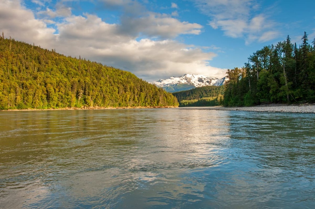
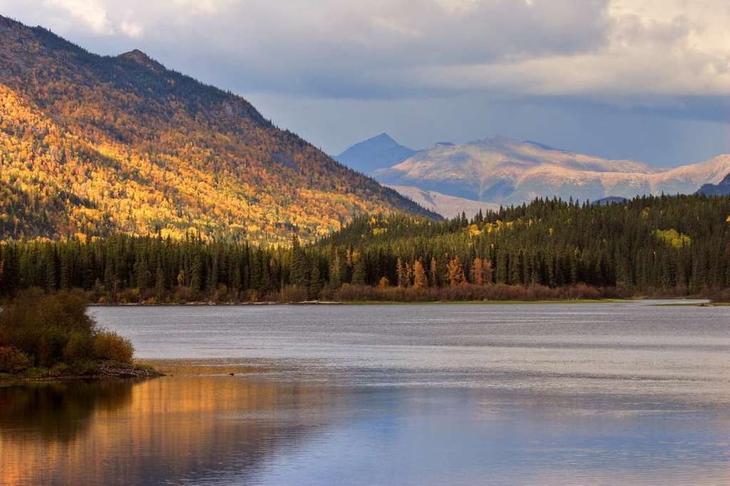
Located in northern British Columbia, Canada, Stikine River Provincial Park features 80 km (48 mi) of a steep-walled canyon that has been dubbed the “Grand Canyon” of the north. The park follows the Stikine River between Spatsizi Plateau Wilderness Provincial Park and Mount Edziza Provincial Park. There are 4 named peaks in the riverside park, the highest and most prominent of which is Mount Meehaus (1,958 m/6,424 ft).
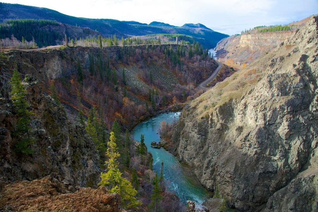
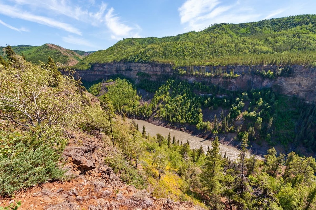
Stikine River Provincial Park is located in northern British Columbia, Canada. It follows the Stikine River corridor from the Cassiar Mountains across the Stikine Plateau to the border of the Boundary Ranges of the Coast Mountains. The park contains 80 km (48 mi) of a steep-walled canyon that is nicknamed the “Grand Canyon” of the north.
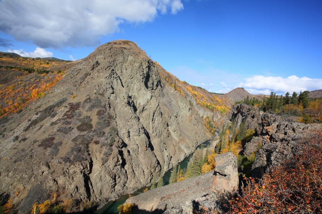
The Stikine River varies in width from 2 m at its confluence with the Tanzilla River to as much as 200 m wide. The river has carved through as much as 300 m (1,000 ft) of sedimentary and volcanic rocks to create the massive canyon that we see to this day.
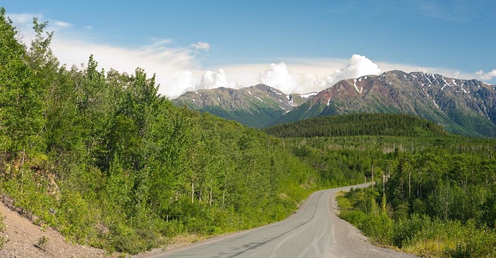
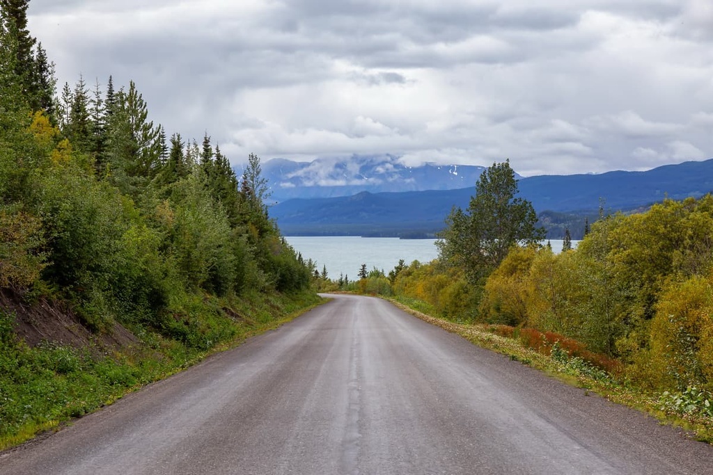
The park is accessible via Highway 37 and along the Telegraph Creek Road, which runs between Dease Lake and Telegraph Creek. Stikine River Provincial Park creates a protected corridor between Spatsizi Plateau Wilderness Provincial Park in the east and Mount Edziza Provincial Park in the west.
Stikine River Provincial Park is part of the Stikine Country Protected Areas of northern British Columbia, which includes seven other parks and protected areas. The other protected areas of Stikine Country are:
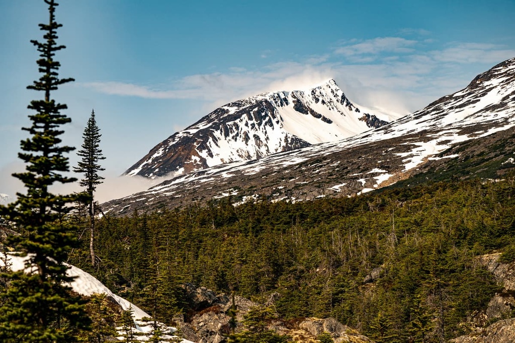
Stretching across the Stikine Plateau from the Cassiar Mountains to the Coast Mountains, Stikine River Provincial Park has four named mountains. The tallest and most prominent of the park’s mountains is Mount Meehaus. Mount Meehaus stands 1,958 m (6.424 ft) tall and has 1,048 m (3,438 ft) of prominence.
The Stikine River cuts across the Stikine Plateau and forms the border between the Nahlin Plateau and the Klastine Plateau. The Nahlin Plateau extends to the northwest from the Stikine River while the Klastine Plateau extends to the south from the Stikine River.
Additionally, Nahlin Plateau is located to the north of the Stikine River and is dominated by the massive Level Mountain. Level Mountain is a large shield volcano. It is an unwooded, low dome-shaped, almost circular mass that is 32 km (20 mi) in diameter. Meszeh Peak is the tallest peak on Level Mountain at an elevation of 2,164 m (7,101 ft) above sea level.
Streams have eroded parts of the volcanic dome, cutting through the layers of basaltic lava. Cirque glaciers have scalloped some of the valley headwalls, too. Meanwhile, the northward movement of the Pleistocene ice sheet across the plateau is shown by the shape of the drumlins upon the plateau itself.
The Klastine Plateau is located on the south side of the Stikine River and is roughly 1,500 m (5,000 ft) in elevation. The Eaglenest Range and Three Sisters Range are located to the east of the Klastine Plateau while the Tahltan Highland and the Klappan Range of the Skeena Mountains are located to the west.
The plateau is a rolling upland that represents the late Tertiary erosion surface, which is widespread across the Stikine Plateau. The erosion surface was formed on Paleozoic and Mesozoic sedimentary and volcanic rocks and only has a few small intrusive stocks.
The plateau is deeply incised by the region’s rivers, with the Stikine River cutting down 750 m (2,500 ft) from the surface of the plateau. For about 80 km (48 mi) upstream of Telegraph Creek, the Stikine River flows through the Grand Canyon of the North. The canyon was likely eroded after it was diverted from its original channel by both Pleistocene and recent lava flows that originated at Mount Edziza.
Glacial ice once extensively covered the plateau during the Pleistocene, and it still remains as the cap upon Mount Edziza. The glaciers' erosional and depositional effects are visible across the plateau. Cirques were cut into northern and eastern peaks and the upland surfaces have been subdued by erosion and the deposition of glacial drift.
Many glacial lakes formed in the presence of downstream ice blockages and the drainage of the region was heavily modified during the Pleistocene. The shape of drumlins across the plateau indicate that the ice sheet flowed south from an ice divide that was located somewhere near Nuttlude Lake.
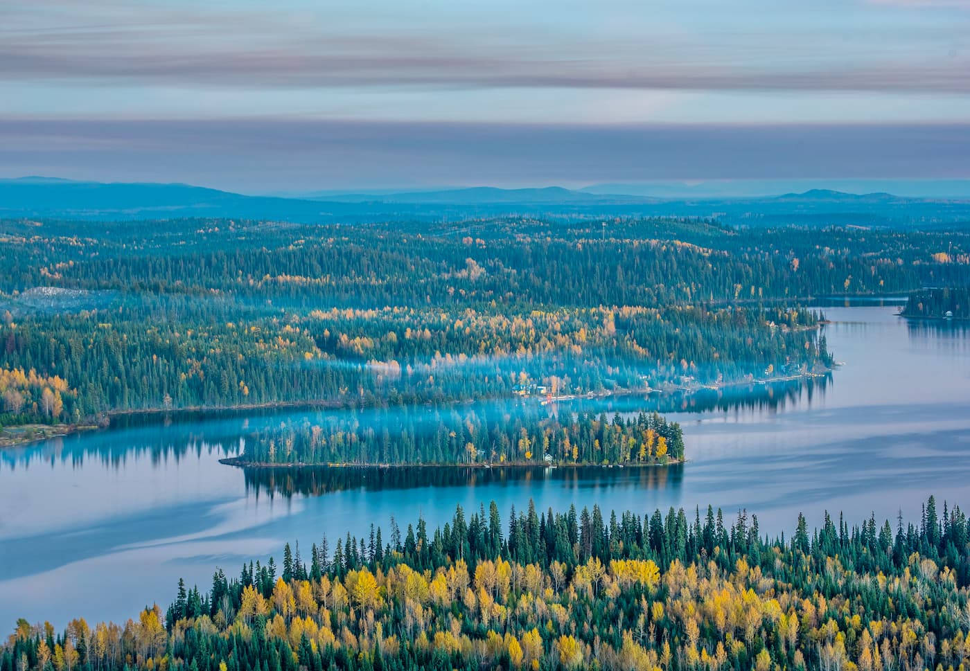
Stikine River Provincial Park is located in an area dominated by the Boreal White and Black spruce ecological zone. This extensive belt of boreal forests that dominates northern Canada occupies the valleys and lowlands of the southern regions of the park. However, surrounding the park, the land is primarily a subalpine area that is dominated by the Spruce-Willow-Birch zone.
The winters in the park are long and cold, and the growing season is short. The ground remains frozen for significant portions of the year, making it difficult for trees to grow as large as they do in the south. The typical landscape is a mosaic of black spruce bogs, successional forests of lodgepole pine and aspen, stands of white spruce, and stands of trembling aspen.
The park is inhabited by both grizzly and black bears, as well as coyotes and wolves. The Grand Canyon of the Stikine provides habitat for the more than 300 mountain goats that live high on the canyon's cliff faces.
Stone sheep, caribou, and also moose also reside in the park. The park even features part of the low elevation forested winter range for the Spatsizi caribou subpopulation.
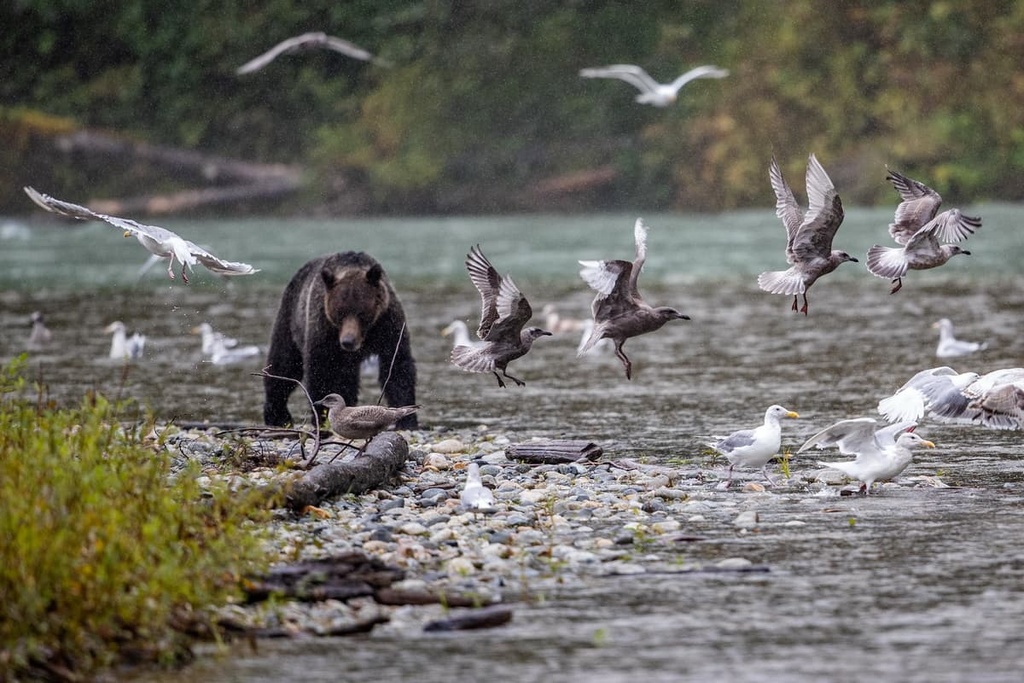
The Stikine River contains multiple species of salmon, and the park contains diverse habitats that are important to many bird species. Additionally, the park hosts a number of rare dry steppe plant communities.
The Pleistocene ice sheet had mostly retreated from the British Columbia Interior Mountains by about 10,000 years ago. Since the melting of the ice sheet, various cultures and communities have inhabited the Stikine Plateau and the area around the Stikine River.
The Stikine and Spatsizi areas have been home to the Denendeh First Nations, including the Tahltan, Sikani, and the Tsetsaut, since time immemorial. The Tahltan have been the primary First Nations group living upon the Spatsizi Plateau, while the Sikani and Tsetsaut traditionally lived to the east and south.
The Tahltan First Nation is now headquartered around Telegraph Creek; however, their traditional territory includes parts of the Boundary Ranges, Stikine Plateau, Skeena Mountains, and the northern Cassiar Mountains.
Stikine River Provincial Park, along with the Pittman River Protected Area and the Chukachida Protected area are tasked with preserving culturally important sites. Some of the culturally important sites found within these areas are First Nations villages, spiritual sites, pre- and post-contact historic routes and trails, and sites pertaining to the European settlers, fur traders, and outfitting guides of the area.
Traditionally, the First Nations of the plateau spent summers fishing along the Stikine River and winters hunting among the uplands. The First Nations traditionally lived in temporary camps that they transported with them along their seasonal rounds. They would net trout and whitefish from lakes and rivers and would primarily use snares to capture caribou, sheep, goats, marmots, ground squirrels, and ptarmigans.
Travel and trading would routinely occur between Telegraph Creek and Fort Ware, within the Rocky Mountain Trench. Additionally, the Tahltan First Nations would trade with the Tlingit, who traditionally live throughout the region that is now the Alaskan panhandle. The Tahltan have historically collected and traded obsidian across the region, which they collected from the slopes of Mount Edziza.
During the late 1700s and early 1800s, when the Russians monopolized the north coast fur trade, the Tlingit traders often worked as middlemen for the Russians and the Tahtlans. This likely represented their first indirect contact with Europeans.
However, the arrival of Europeans also signaled the arrival of many infectious diseases that First Nations had no natural immunity to. These infectious diseases, such as smallpox and measles killed an estimated 90 percent of First Nations citizens in the region.
Currently the tribal and provincial governments are working together to create a system that promotes industry in the region while balancing that with the desire to preserve the wilderness and the values of the First Nations. Mining, drilling, and forestry are major industries in the region; however, First Nations leaders are striving to maintain their cultural values while encouraging responsible industrial use of the territory.
Stikine River Provincial Park is home to one of many national treasures in northern British Columbia. The main attraction in the park is the Grand Canyon of the Stikine, which is about 80 km (48 mi) long and reaches a depth of nearly 300 m (1,000 ft). The steep-sided cliffs and the rushing water in the canyon are a spectacular sight to behold.
The park offers hunting, fishing, backcountry camping, photography, river rafting, kayaking and canoeing, hiking, cross-country ski touring, and wildlife viewing opportunities as well as opportunities for the appreciation of human history.
Aside from a short hike that leads from Highway 37 to an overlook of the Tuya River Valley, there are no other developed trails in the park. The remaining trails through the park are part of the historic routes that First Nations and fur traders used while traversing the area for trade and sustenance.
Canoeing and kayaking are among the most popular activities at the park and paddling on the upper Stikine River can be an enjoyable experience. The lower Stikine River that flows through the Grand Canyon, west of Highway 37 is considered dangerous and unnavigable by any watercraft. As a result, it should not be attempted by paddlers.
Northern British Columbia is a vast and remote wilderness with few towns and cities. Here are some of the communities you can visit when traveling to and from Stikine River Provincial Park:
The town of Dease Lake is located about 40 km (24 mi) to the north of the Stikine River and Stikine River Provincial Park along Highway 37. With a service station, fuel, a hotel, and a store, the town receives many visitors as they drive along the Stewart-Cassiar Highway toward other destinations.
It is located at the junction to Telegraph Creek and its overland hiking route to Mount Edziza.
In 1837, Hudson’s Bay Company built a trading post on the shores of Dease Lake, then known as Lake House, which became a major stop for prospectors traveling to the gold rush in the Cassiar Mountains during the nineteenth century.
While the town still benefits from local gold, copper, and jade mining, it is also a destination for hunting and other wilderness activities. Dease Lake is located along the ancient Hyland Post Trail. and it is situated at the junction at which to turn off Highway 37 to reach the trailheads that can take you to Mount Edziza Provincial Park.
Some of the nearby hiking and backcountry wilderness areas around Dease Lake include Mount Edziza Provincial Park, which offers the opportunity to hike along a volcano; Stikine River Provincial Park, which is home to the Grand Canyon of the north; and both Gladys Lake Ecological Reserve and Spatsizi Plateau Wilderness Provincial Park, which feature incredible natural beauty and fascinating ecologies.
Prince George is located at the junction of Highways 16 and 97, and it is the major service and transportation center for the north of British Columbia. Most flights into northern British Columbia pass through Prince George.
Even though the city is situated in the remote northern wilderness of British Columbia, Prince George offers fine dining, movie theaters, and other entertainment options in addition to some great hikes around town. Some of the most popular hikes are the Cottonwoods Island Loop, the Greenway Trail to Shane Lake Loop, McMillan Creek Loop, Troll Lake, Kakwa Lake Trail, and Forests for the World Lookout.
Additionally, off-roading is a popular pastime of locals in the region. There are well-established clubs and areas to practice motocross and drive OHVs near the city. Fishing, canoeing, hunting, and winter activities such as snowmobiling, snowshoeing, and backcountry skiing, are also popular regional activities.
Located along Highway 37 in northern British Columbia, Iskut is a small community that is home to the headquarters of the Iskut First Nation. It is located about 50 km (35 mi) to the south of the Stikine River Provincial Park. The community is the last stop before the park, and it offers shopping and fuel.
The town is situated near the trailhead for the overland routes into Gladys Lake Ecological Reserve and Spatsizi Plateau Wilderness Provincial Park. Other hiking and camping areas that are located nearby include Stikine River Provincial Park, Mount Edziza Provincial Park, Tatlatui Provincial Park, and Todagin South Slope Provincial Park.
The opening of Highway 37 has increased access to the region’s recreational opportunities. Guided hunting and fishing trips are popular activities in the area. Fishing in the Iskut Chain Lakes and hunting in the nearby wilderness areas are particularly popular. Snowmobile and OHV use are also common pastimes for community residents.