
Scan the QR code and open PeakVisor on your phone
Mount Edziza Provincial Park is located in the northwestern region of British Columbia, Canada. It is situated to the east of the Boundary Ranges of the Coast Mountains and it covers some 2,660 square kilometers (1,031 square miles) of the Tahltan Highlands. The park features a spectacular volcanic landscape with 41 named mountains, of which Mount Edziza is the tallest and most prominent with an elevation of 2,793 m (9,163 ft) and a prominence of 1,760 m (5,774 ft).
Located in northwest British Columbia, Canada, Mount Edziza Provincial Park is situated to the west of the Stewart-Cassiar Highway (Highway 37); however, there is no road access into the park. The park is located in the Kitimat-Stikine Regional District, which is one of the least populous parts of the province.
Indeed, the nearest communities to Mount Edziza, both of which are located off of Highway 37, are Telegraph Creek at the northwest corner of the park and the community of Dease Lake, the latter of which is located about 50 km (30 mi) to the northeast of the park. Telegraph Creek is home to around 60 residents while Dease Lake has some 350 residents. Both communities have basic amenities, particularly Dease Lake, which is a popular stop for tourists heading to Yukon and Alaska.
Furthermore, Mount Edziza Provincial Park sits on the Tahltan Highlands on the Stikine Plateau. The Boundary Ranges of the Coast Mountains are located to the west of the park.
Additionally, there are a number of other parks and protected areas near Mount Edziza. In particular, Stikine River Provincial Park, Spatsizi Plateau Wilderness Provincial Park, Kinaskan Lake Provincial Park, and the Gladys Lake Ecological Reserve are all located to the east of Mount Edziza.
Mount Edziza Provincial Park contains a unique volcanic landscape that includes cinder cones, cinder fields, basalt plateaus, and lava flows.
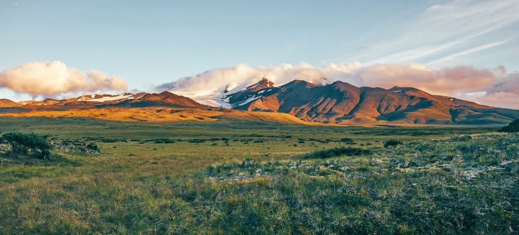
However, the highlight of the park is easily the massive stratovolcano Mount Edziza, which has an elevation of 2,793 m (9,163 ft) and an astounding prominence of 1,760 m (5,774 ft). The formation of the Mount Edziza volcanic complex, and the greater Stikine Volcanic Belt, began about 20 million years ago when a rift zone began to open in the continent.
While the tectonic plates under the Pacific Ocean collided with North America for over 100 million years, creating the Western Cordillera of the Coast, Columbia, and Rocky Mountains, about 20 million years ago the Pacific plates started sliding north. In doing so, the continental plate began to stretch, creating faults parallel to the rift, through which magma rose to create the volcanic belt.
The Mount Edziza volcanic complex began to form about 7.5 million years ago and has grown steadily since then. The initial eruption that built Mount Edziza was about 4 million years ago with successive eruptions raising the dome above the plateau and covering over 1,600 square kilometers (630 square miles) with lava.
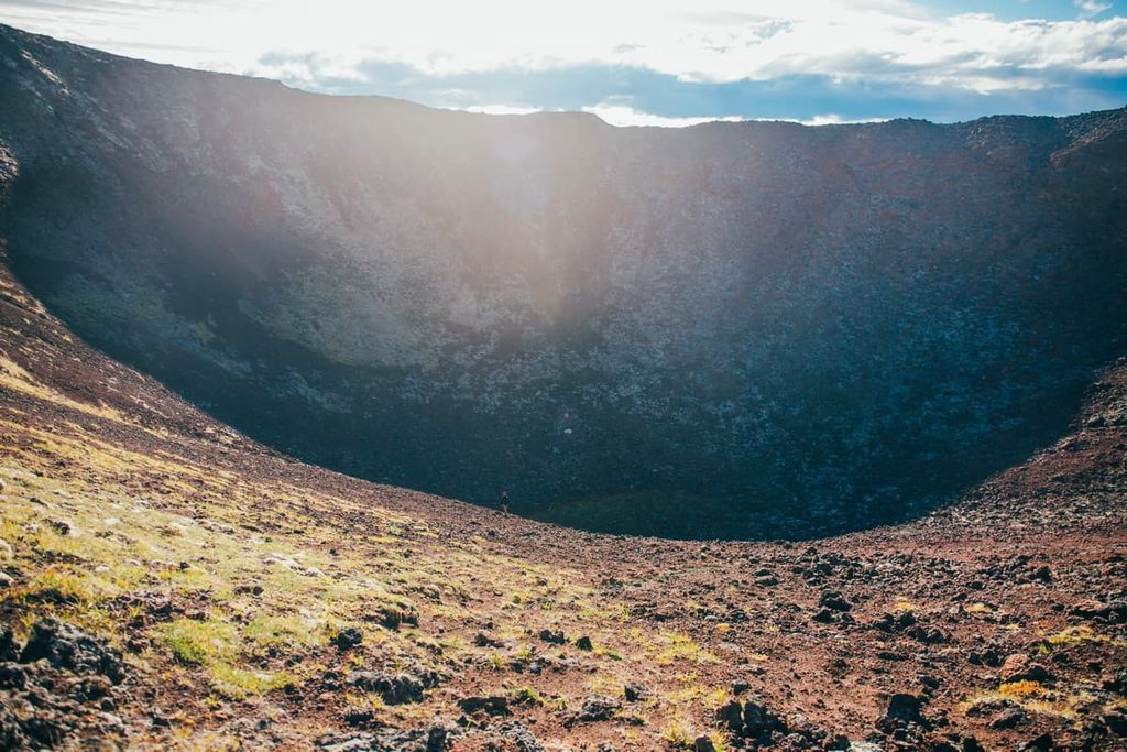
Mount Edziza is a composite volcano with thin basalt flows and andesite, dacite, and rhyolite forming the central dome. The last eruption was only 10,000 years ago, at which time the lava solidified in the central dome, plugging the central vent.
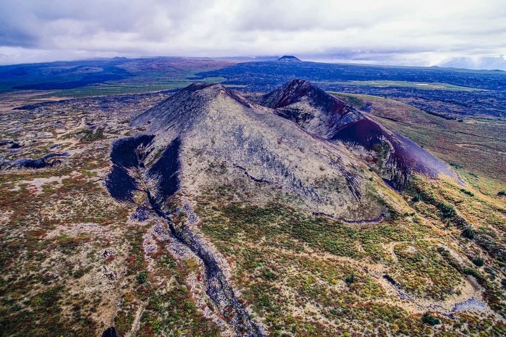
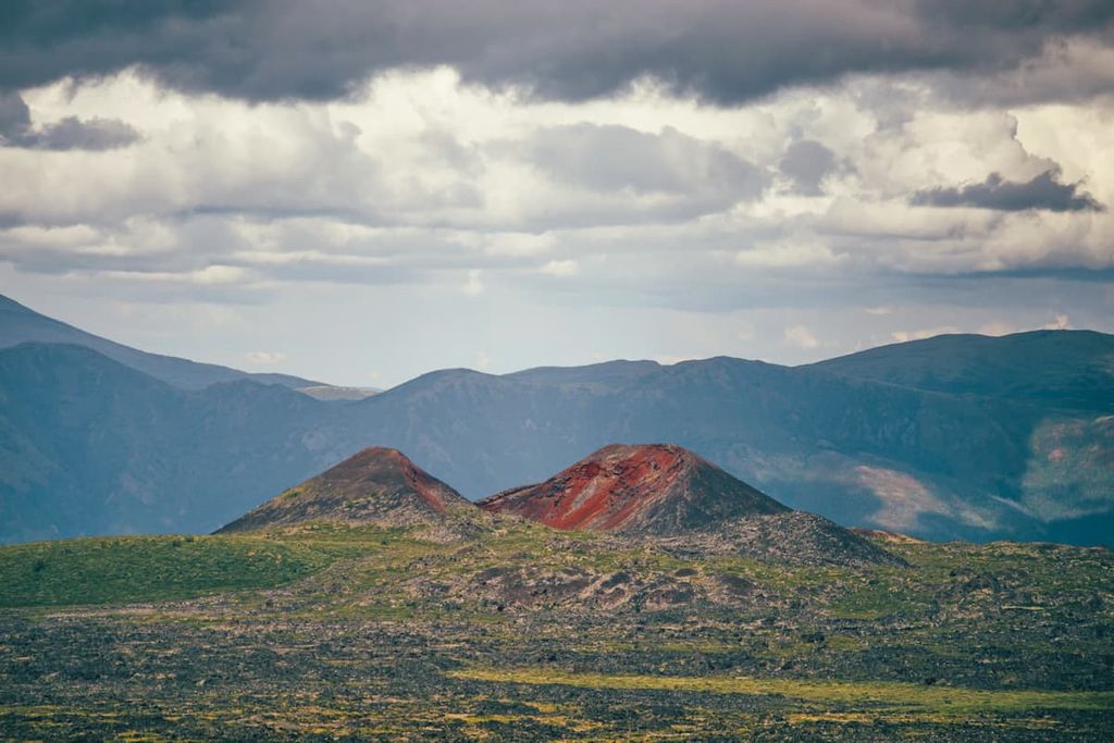
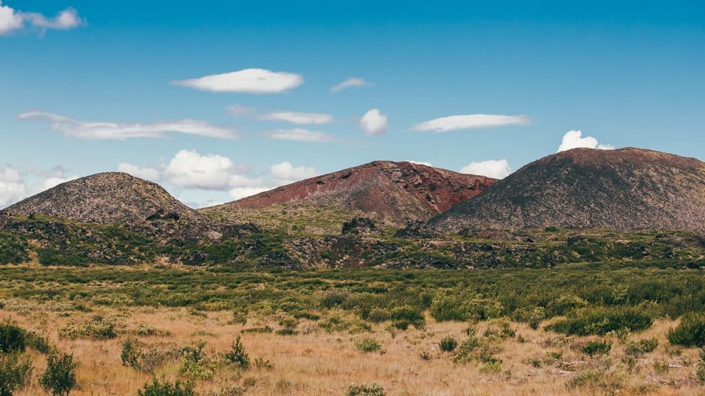
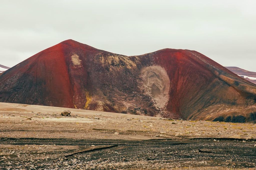
While Mount Edziza has been dormant for the past 10,000 years, over 30 cinder cones have been created from smaller eruptions. The Eve Cone is perfectly symmetrical and rises 150 m (492 ft) above the surrounding plateau, as well as the Cocoa and Coffee craters. These cones are likely no more than 1,300 years old and are effectively unaltered by erosion and devoid of vegetation.
Located to the south of Mount Edziza is the Spectrum Range, which formed from lava flows. The Spectrum Range is named for the brilliant hues of red, yellow, white, and purple rock that was the result of rhyolite being stained by sulfurous mineral waters. Erosion has resulted in a spectacular landscape that resembles a vast watercolor painting.
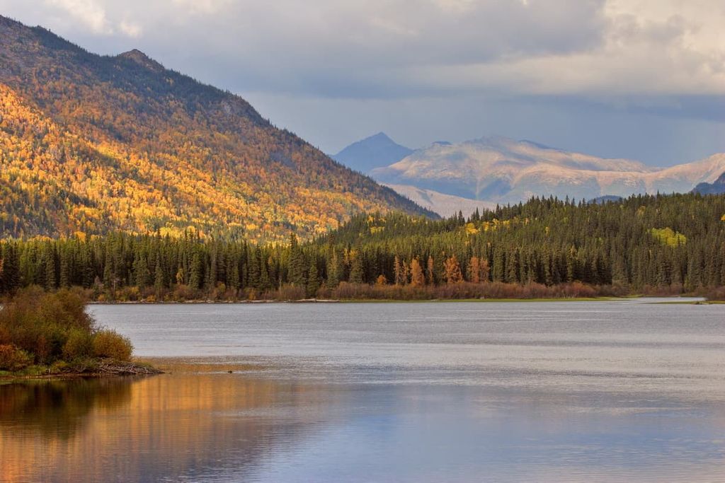
The ecology of Mount Edziza Provincial Park ranges from dense boreal forests to a completely barren landscape that is completely devoid of flora and fauna. The park sits upon a plateau that was created by an active volcano complex, with the last eruption occurring only 1,300 years ago.
The center of the park is a barren wasteland that is covered in lava flows and cinder fields that haven’t even existed long enough for significant erosion to occur, let alone vegetation to take hold. Moving out from the main volcanic flows, shrublands, wetlands, and peat meadows create a mosaic upon the plateau.
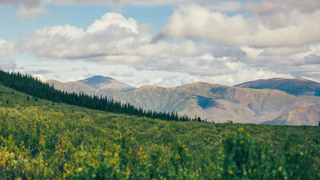
At the lowest elevations, along the river valleys, white spruce is the dominant conifer with lodgepole pine and trembling aspen growing on the drier sites while balsam poplar prefers the wetter sites. Moose are the most common animal seen in the park, with Osborn caribou, Stone sheep, and mountain goats sometimes seen on the plateau and slopes of Mount Edziza.
There are many black and grizzly bears in the park which are often seen above the treeline where Arctic ground squirrels are plentiful. Additionally, wolves are often heard in the park; however, they are rarely seen.
The slopes of the volcanoes of the Mount Edziza volcanic complex were a place where Indigenous communities started quarrying obsidian over 10,000 years ago. The volcanic glass was valuable as a trade material because it was durable and could be refined to make razor sharp tools and hunting points.
The park is the traditional territory of the Tahltan people, who have resided in the region since time immemorial. The Tahltan have continued the traditional practice of quarrying and trading obsidian. The obsidian from Mount Edziza and the surrounding volcanoes has been found in archaeological sites across northern British Columbia and it has been found as far away as northern Alberta and Alaska.
The European-driven fur trade came to the area by 1824. This was followed by gold discoveries in the region. The Telegraph Trail, which runs nearly 3,000 km (1,800 mi) and linked Dawson City in Yukon to the rest of Canada during the Yukon Gold Rush, was constructed between 1897 and 1901.
The portion of the Telegraph Trail that passes through the Regional District of Kitimat-Stikine is over 500 km (300 mi) long. It actually passes through Mount Edziza Provincial Park and it historically played an important role in communication and transportation in the region during the early twentieth century. The telegraph line had cabins every 32 km (19 mi) for operators and was in use until 1932, when radio replaced the telegraph.
The Telegraph Trail was the only major infrastructure to be created in Mount Edziza Provincial Park. The trail was widely used by travelers, hunters, and others; However, the trail is now considered impassable and all that remains in the park are a few poles and collapsed line cabins. The area was designated a provincial park in 1972.
Mount Edziza Provincial Park doesn’t have any maintained trails; however, there is a route that traverses the park as well as several overland hiking routes to access the park. The following are brief trail descriptions.
Starting from Kinaskan Lake Provincial Park to the east of Mount Edziza Provincial Park, the Mowdade Lake Trail is a 24 km (15 mi) route that leads to a terminus of the popular Buckley Lake to Mowdade Lake route.
While the trail is usually wet, there are no panoramic views, and the route requires a boat crossing or a long ford across the Iskut River at the trailhead, it is the gateway to the spectacular landscape of Mount Edziza Provincial Park.
This overland route to Buckley Lake starts in the northwest of the park at Telegraph Creek. The route begins with a boat crossing of the Stikine River followed by steady hiking to Buckley Lake roughly following Mess Creek.
The trail does come to a junction with the old Telegraph Creek Trail and it is easy to get confused or miss where you are supposed to turn. Proper route planning and preparation are especially important for an excursion into the remote Mount Edziza Provincial Park.
The route between Buckley Lake and Mowdade Lake is approximately 75 km (45 mi) and is usually travelled over a period of seven days. The distance of the route varies as there is no official trail to follow, only a suggested route.
Starting from Buckley Lake, the route typically passes the Sidas and Eve Cones before traversing the western slopes of Mount Edziza. The landscape is incredible and rugged, as you traverse lava fields as well as fast flowing creeks.
The route continues from the west side of Mount Edziza past the Coffee and Cocoa Craters and then it meets up with Chakima Creek. Following Chakima Creek, the route through the park finishes at Mowdade Lake where hikers can be picked up by float plane or hike the overland route to Kinaskan Lake Provincial Park.
The route through the Spectrum Range can be done as a week-long trek, similar to the Buckley Lake to Mowdade Lake trail, where the route ends at Mowdade Lake. Or it can be completed as a longer traverse that takes you all the way to Buckley Lake. The full traverse from Little Ball Lake to Buckley Lake is expected to take about 10 days.
The route through the Spectrum Range passes through rugged and difficult terrain along with many creek crossings that can get you wet up to your waist. The scenery is stunning as you get a close-up view of the spectacular watercolor-like hues that give the range its name.
Some of the highlights of the trip are passing by Kuno Peak and climbing the imposing Yagi Ridge. Nagha Creek has been known to swell and become near impassable when the weather is warm and the glacier is melting fast; however, crossing early in the morning or near the glacier can make it easier, though there’s no substitute for good decision making and river crossing experience.
The route continues up onto the Kitsu Plateau where obsidian can be found. From the plateau, the route descends down from Raspberry Pass. Depending on the time of year, the pass and many areas of the park can be covered with beautiful swaths of wildflowers.
The route follows Walkout Creek where it will finally meet up with Chakima Creek. From here hikers can make their way out of the park via Mowdade Lake or continue north to Buckley Lake. Forest fires are an issue around the park and parts of the park may be shut down due to forest fires or the smoke will make it impossible for planes to drop off or pick up. Be sure to check local weather conditions before heading into the park.
The routes through Mount Edziza Provincial Park require advanced hiking and route finding skills and should not be attempted without proper and thorough preparation. While it is possible to hike overland routes to the lake starting points, most people choose to be flown into and out of the park.
Located in the remote wilderness of the Regional District of Kitimat-Stikine, Mount Edziza Provincial Park is difficult to access and there are few communities nearby. The following are the major communities near the park.
The town of Dease Lake is situated about 50 km (30 mi) northeast of Mount Edziza Provincial Park. The town has a service station, fuel, a hotel, and a store. Many visitors pass through the town on their way to the Alaska Highway and other tourist destinations. The junction to Telegraph Creek and its overland hiking route to Mount Edziza is at Dease Lake.
In 1837, Hudson’s Bay Company built a trading post on the shores of Dease Lake, known as Lake House. The post became a major junction for miners travelling to the gold rush in the Cassiar Mountains. The town still benefits from local gold, copper, and jade mining. It is also a destination for hunting and other wilderness activities.
Located across the Stikine River from the northwest corner of Mount Edziza Provincial Park, the community of Telegraph Creek is one of the best overland access routes into the park. While the region has been inhabited by the Tahltan for thousands of years, the history of people of European descent in Telegraph Creek dates back to the Stikine and Cassiar gold rushes in the 1860s and 1870s.
The access to Telegraph Creek is by river, air, or a 112 km (67 mi) gravel road with steep gradients, narrow passages along canyon walls without guardrails, and sharp angled switchbacks. However, the scenery is remarkable and the opportunity to hike in the stunning Mount Edziza Provincial Park makes the drive worthwhile.
Tatogga Lake is located to the east of Mount Edziza Provincial Park along Highway 37. The resort has hotel accommodations as well as an RV park. There is a restaurant and fuel station for those that are passing through and wilderness experiences for those that are wanting to stay for a bit.
The resort has canoe rentals and access to trails for hiking and cycling. There are places for fishing as well as opportunities for hunters. Floatplanes are often based out of the resort to fly guests on tours of the incredible mountain ranges or to shuttle guests to remote hiking, fishing, hunting, paddling areas, such as Low Ball, Mowdade and Buckley Lakes to hike in Mount Edziza Provincial Park.


