Scan the QR code and open PeakVisor on your phone
Whitehorse Wildland Provincial Park is a stunning wilderness destination located along the eastern slopes of the Canadian Rockies in central Alberta, Canada. The park is filled with trails that lead to scenic vistas among its dense forests and many peaks. It contains 11 named mountains, the highest and most prominent of which is Blackface Mountain (2,867 m/9,406 ft).
Home to some of the most stunning eastern slopes and foothills in central Alberta, Canada, Whitehorse Wildland Provincial Park is a superb backcountry wilderness destination. Among the 11 named mountains of the park, of which Blackface Mountain is the tallest and the most prominent, there are many incredible trails and attractions.
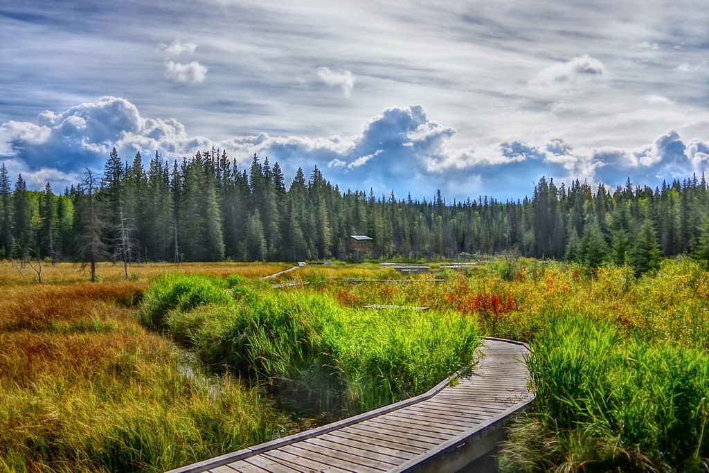
Lush forests, wide-open alpine meadows, crystal clear rivers and creeks, limestone caves, and panoramic summit views are the main attractions of the park. The park is also located on the eastern edge of the Miette and Nikanassin ranges of the Canadian Rockies.
Whitehorse Wildland Provincial Park borders Jasper National Park, which is one of the most beautiful national parks in Canada. Some of the other major national and provincial parks situated near Whitehorse Wildland Provincial Park include:
Whitehorse Wildland Provincial Park covers part of the Miette and Nikanassin ranges of the Canadian Rockies. As they are part of the front ranges of the Rocky Mountains, the mountains of the park were among the final mountains of the Rockies to form.
The Rockies started forming about 75 million years ago during the Laramide orogeny. This mountain-building event began when tectonic plates under the Pacific collided with the continental plates under North America. This compressed the continental margin, causing deformation and uplift of the crust.
The southwestern mountains of the Canadian Rockies were the first to form. Since the tectonic collision of the range occurred in a northeast orientation, the northeastern ranges, including the Miette and Nikanassin ranges, were among the final ranges to form.
As these tectonic plates continued to collide and the oceanic plate subducted beneath the continent, the compression heated, deformed, bent, and cracked the layers of rock. These massive layers of Paleozoic limestone and dolostone cracked and were squeezed to the point that the layers lifted and stacked on top of the Cretaceous sandstones and shales to the northeast.
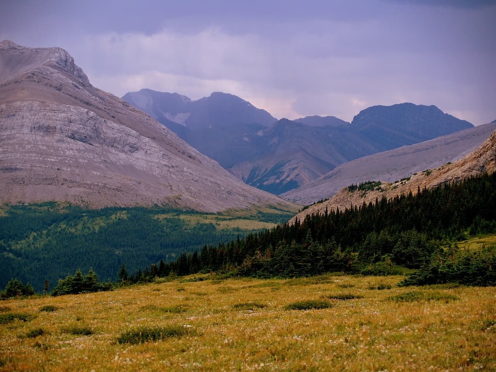
The mountains continued to form as thrust faulting occurred, which is where layers of rock crack and uplift onto the ground. The front ranges are characteristically composed of near-vertical mountain faces as the layers found in the range were thrust in a near-vertical orientation.
The peaks and ridges of the Whitehorse Wildland Provincial Park are made of durable limestones and dolomites. Meanwhile, the softer Cretaceous sandstones and shales in the region were heavily eroded away to create the valleys that are located between the park’s peaks.
The Foothills lie to the east of the Rockies and were formed after the front ranges. As the force of the tectonic collision dissipated, there was no longer enough energy to fault and thrust the deeper Paleozoic layers of rock. As a result, only the upper Cretaceous layers of rock were broken and stacked in the foothills.
In the foothills, various layers of sandstones and shales were thrust upward. Many of the Rocky Mountain foothills resemble rows of roof shingles that drop off sharply toward the valleys that are located to the east.
There were several major events that formed the topography of the park as we know it today. The first event was the mountain formation itself, where layers of rock were thrust into a near-vertical orientation in the front ranges of the Rockies.
The second event that formed the park’s topography was the massive erosional force of the mountains rising and the subsequent displacement of a shallow sea.
In fact, before the Rockies rose, a shallow sea covered the western edge of Alberta, though it was displaced during the Laramide orogeny. This displaced water created a massive erosional surface, wearing away the softer Cretaceous rocks and depositing layers of sediment in the eastern prairies.
The final event that shaped the topography of Whitehorse Wildland Provincial Park was the Pleistocene glaciation. The Cordilleran ice sheet covered the Rockies in over 1 km (0.6 mi) of ice while the Laurentide ice sheet covered the rest of Canada to the east of the Rockies.
During this time, glaciers scoured the softer rocks from the valleys and even eroded portions of the region’s limestone peaks. Alpine glaciers created cirques, tarns, and alpine valleys. Cirques are created as glaciers recede from the tops of mountains leaving a bowl-like depression in the side of a mountain, and tarns are lakes that reside in cirques and other alpine glacial depressions.
Nowadays, the landscape is covered with moraines, eskers, and kames, all of which are piles of glacially eroded rocks and sediment that were deposited by the glaciers in different ways. Moraines and kames are typically piles of glacial till while eskers are sinuous ridges formed by the deposition of glacial till from sub-glacial rivers.
Since it is located within the Rocky Mountains, Whitehorse Wildland Provincial Park is part of the Rocky Mountain Natural Region and, in particular, the Alpine, Subalpine, and Montane subregions. The alpine exists above the treeline while the subalpine covers the slopes of the mountains and the montane subregion encompasses the valley floors.
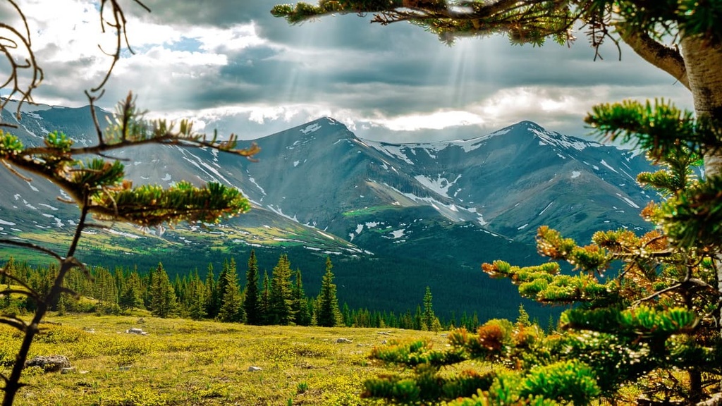
The alpine is the coldest of these subregions and receives the most precipitation. Here, the winters are long and cold but they are accompanied by a short growing season. Whitehorse Wildland Provincial Park has significant alpine areas that are filled with rocky peaks and vast alpine meadows.
Communities of sedge and heath cover the alpine meadows in the park, and the wildflowers are both stunning and abundant in their season. Trees that do manage to grow in the alpine subregion are stunted and twisted from the fierce winds that blow over the peaks.
Subalpine fir tends to dominate the tree line; however, the longer-lived spruce dominates the forest canopy. Lodgepole pine prefers to grow in dry areas in the park and will typically be the primary pioneer species to repopulate the forests after a wildfire.
Beautiful larch trees are typically found along ridges in the park and there are also scattered stands of aspen. Willow and poplar tend to grow only in the park’s valleys where there is significant moisture.
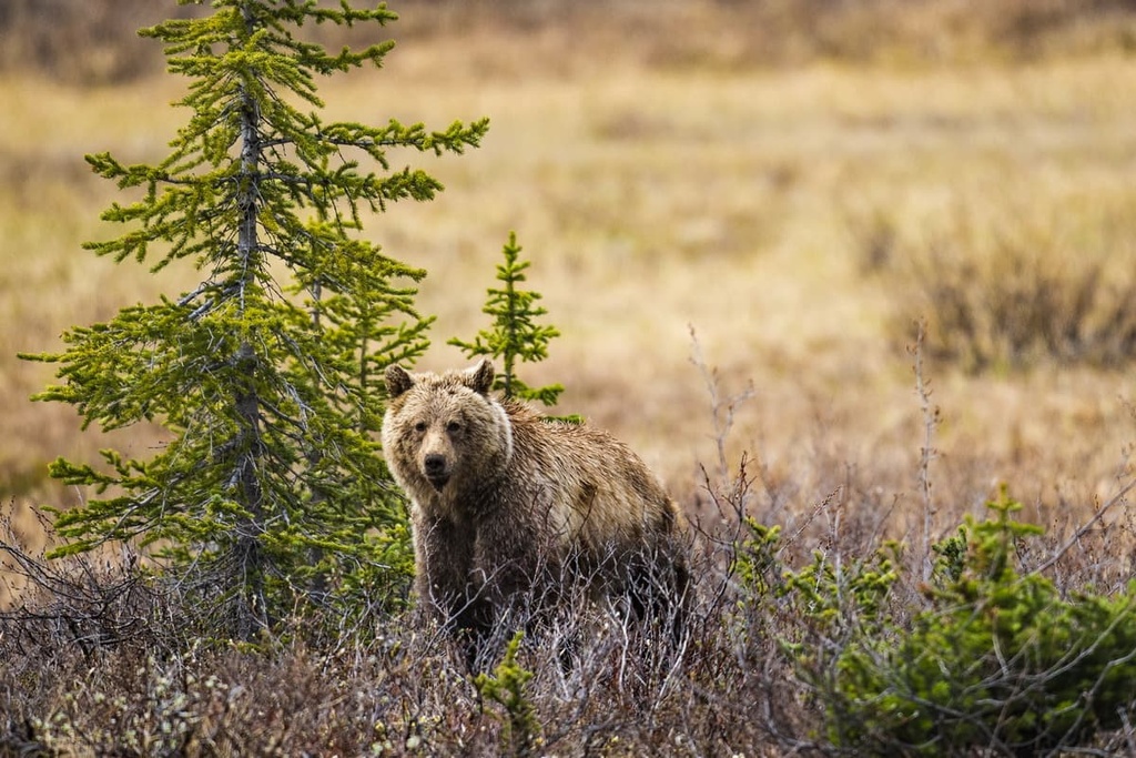
Many animal species inhabit the wildland park, such as grizzly bears, moose, elk, black bears, wolves, deer, cougars, and foxes. Mountain goats and bighorn sheep both inhabit the rocky peaks of the range, while most other animals only live in the region’s forests.
Marmots, pikas, and several bird species, such as the American pipit and the white-tailed ptarmigan, also inhabit the alpine areas of the park; however, the birds generally only live in the alpine for the summer nesting season.
Around 12,000 years ago, as the ice sheet was nearly melted and the glaciers were receding towards the mountain peaks, the eastern slopes of the Rocky Mountains became one of the first habitable areas in what is now western Canada.
During this time, an ice-free corridor opened along the eastern ranges and slopes of the Canadian Rockies. It gradually extended toward the east and west as it grew to connect what is now Yukon and Alaska with Alberta and Montana. This ice-free corridor also included the area that is now Whitehorse Wildland Provincial Park.
However, the ice-free corridor had frozen shut between about 20,000 and 13,000 years ago, at which time the climate warmed and the route has since remained free of ice. As the corridor re-opened, vegetation was able to take hold and flourish in a steppe-like environment. As grasslands were created, migratory animals began to move north along the eastern slopes of the Rockies.
Following the grazing animals were their predators, which included the ancient people of North America and the ancestors of many contemporary First Nations. Whitehorse Wildland Provincial Park is also located within the traditional territory of the Ktunaxa, Tsut T’ina, Stoney Nakoda, and Cree First Nations, as well as the Métis Nation.
The westward expansion of the fur trade was responsible for early European settlement near Whitehorse Wildland Provincial Park. Jasper House was one of the first European trading posts to be built in the area and it later became the town of Jasper in Jasper National Park.
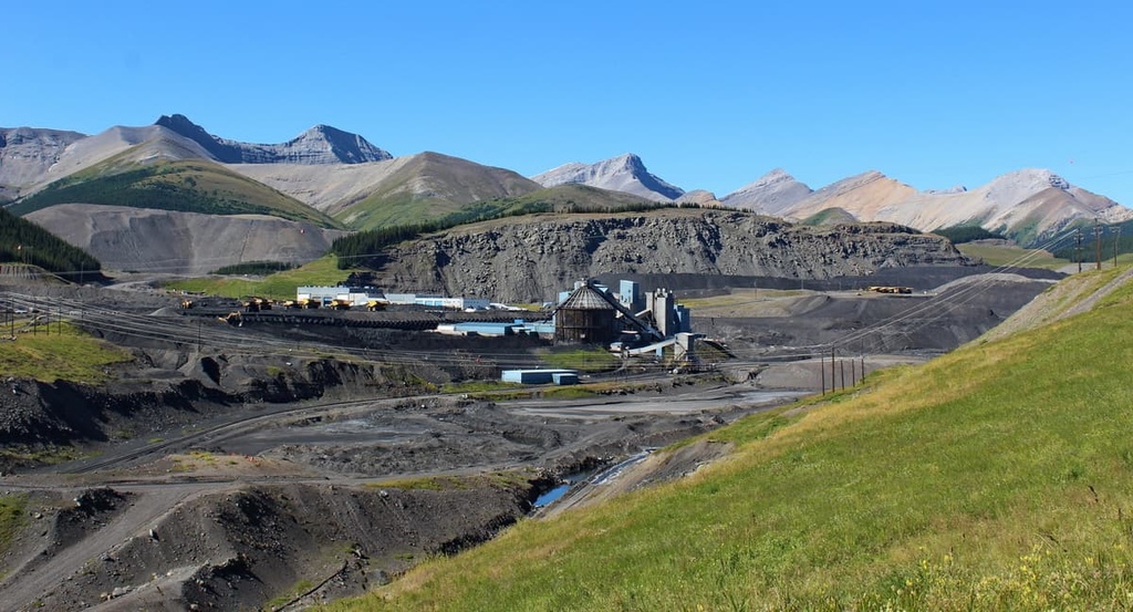
As the fur trade declined, mining became a major economic driver in the region, particularly as vast ore and coal deposits were discovered along the eastern slopes of the Rockies in the late nineteenth and early twentieth centuries.
There were homesteads in the region, too; however, with the establishment of Jasper National Park in 1907, many of the homesteaders, who were often First Nations citizens, were evicted and forcibly moved northward toward Grand Cache.
There are many trails that lead to backcountry destinations in Whitehorse Wildland Provincial Park. There are no facilities in the park; however, there are many areas that are designated as backcountry camping sites that are available for visitors to use.
The following are some of the most popular trails in the park to check out during your next trip to Whitehorse Wildland Provincial Park.
The long but relatively flat trail along the Whitehorse Creek is a year-round option for a day hike or an overnight expedition. This nearly 24 km (14 mi) long hike has only 566 m (1,856 ft) of elevation gain and is quite well marked and maintained.
The trail features stream crossing, cliff walks, and extensive travel through the vast northern forest. There is a campsite located toward the end of the trail and there are opportunities for additional hikes to waterfalls and other places from the campground at the end of the route.
The hike to the summit of Tripoli Mountain is nearly 11 km (6.6 mi) long round trip. However, there is nearly 600 m (2,000 ft) of elevation gain over this relatively short distance, so many consider the trail to be quite difficult.
The wide-open upper slopes of Tripoli Mountain offer incredible views as you make your way to and from the summit. Additionally, there are certainly grizzly bears in the area, so hikers have opportunities to see and hear the bears as well as marmots and other wildlife.
The Fiddle River Trail can be hiked point-to-point between Whitehorse Creek in Whitehorse Wildland Provincial Park and Miette Hot Springs in Jasper National Park. This trail is 36.5 km (22 mi) long and it has 1,269 m (4,162 ft) of elevation gain. It features sites for backcountry camping and the trek is usually done over several days.
This trail is good for both experienced hikers and new hikers alike who want to test their stamina. Along this trail, the views are spectacular, especially from Fiddle Pass, and the pass itself is often covered with wildflowers. The trails are well marked and, while it is a long hike with significant elevation gain, there are no significant obstacles to overcome along the way.
Whitehorse Wildland Provincial Park is located along the borders of the beautiful Jasper National Park and the boundaries of a number of other protected areas in the Rocky Mountains. The wildland park is one of many backcountry destinations in the region. Here are some nearby cities and towns to check out during your travels to the area.
Jasper House was the original European trading post in the area, as it was first built in 1813. In 1907, Jasper National Park was established and the town of Jasper was created near the original fort site in order to serve as the commercial center for the newly established park.
By road, Jasper is located about 80 km (48 mi) from Whitehorse Wildland Provincial Park; however, there are hikes through the Miette Range from the national park to the wildland park that offer a shorter and more scenic alternative than the road.
Jasper National Park is considered to have some of the most stunning landscapes and beautiful scenery in Canada. Some of the most popular trails from Jasper are the hike to Sunwapta Peak, the Sulphur Skyline Trail, and the Maligne Canyon Hike.
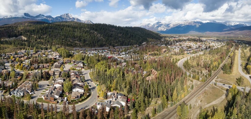
The town of Hinton is the gateway from the eastern prairies into the Rocky Mountains and their incredible mountain parks. Whitehorse Wildland Provincial Park is located about 35 km (21 mi) to the south of Hinton, near the small community of Cadomin.
Hinton is a gateway into the wilderness parks of the northern Rockies. The community is a popular staging area for expeditions into Willmore Wilderness Park, Jasper National Park, Whitehorse Wildland Provincial Park, and Rock Lake – Solomon Creek Wildland Provincial Park, so it’s a great place to stay if you’re looking to adventure in the region.