
Scan the QR code and open PeakVisor on your phone
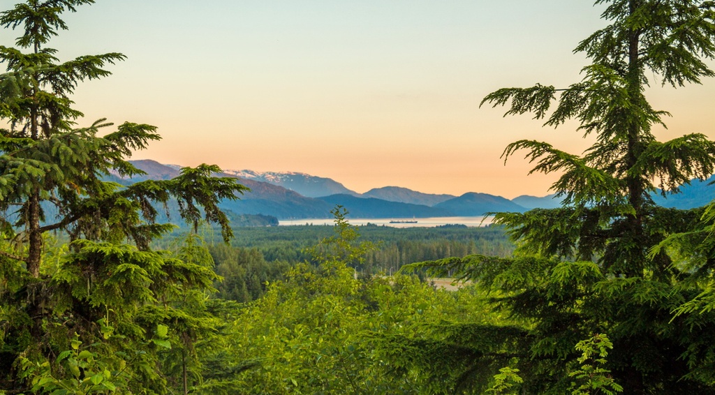
The Huchsduwachsdu Nuyem Jees / Kitlope Heritage Conservancy is a protected area located along the central coast of British Columbia, Canada, in the Kitimat Ranges of the Canadian Coast Mountains. The mountainous terrain in the conservancy contains steep-sided valleys, dramatic granite peaks, and cascading waterfalls. Of the 13 named mountains of the conservancy, Chatsquot Mountain (2,365 m/7,759 ft) is the tallest and most prominent peak.
Located in northwestern British Columbia, Canada, Huchsduwachsdu Nuyem Jees / Kitlope Heritage Conservancy encompasses 322,020 hectares (795,730 acres) of old-growth forests, alpine meadows, rivers and wetlands, waterfalls, and 13 named peaks.
The region is dominated by Chatsquot Mountain, which is the tallest of the peaks in the conservancy. The peak sits at an elevation of 2,365 m (7,759 ft) above sea level and has a prominence of 1,981 m (6,499 ft). This makes it one of two ultra-prominent peaks in the conservancy.
Sharks Teeth Peak is the third tallest mountain in the conservancy, after Khawachen Mountain, and is also classified as an ultra-prominent peak. Sharks Teeth Peak is 2,301 m (7,549 ft) tall and has 1,905 m (6,250 ft) of prominence. A peak is considered ultra-prominent when it has over 1,500 m (5,000 ft) of prominence.
Glaciers feed the headwaters of the rivers that flow through the conservancy. The conservancy itself encompasses the entire Kitlope watershed and part of the Tsaytis watershed. This glacial meltwater gives the region’s rivers a milky blue hue, which is reflected in the Haisla name Huchsduwachsdu Nuyem Jees, which translates as “source of the milky blue water.”
Accessible only by boat and plane, the Huchsduwachsdu Nuyem Jees / Kitlope Heritage Conservancy is a remote area that borders Tweedsmuir Provincial Park to the northeast and Fiordland Conservancy to the southwest. Other parks and protected areas located nearby include:
As they are part of the Kitimat Ranges in the Canadian Coast Mountains, the peaks of the Huchsduwachsdu Nuyem Jees / Kitlope Heritage Conservancy are mainly granitic in nature. The western ranges of the Coast Mountains are mainly granodioritic while the eastern ranges are mainly granitic in composition.
The Coast Mountains were created about 100 million years ago when a superterrane collided with the continent of North America. This caused magma to intrude the layers of sedimentary and volcanic rocks that were located along the west coast of North America.
Referred to as the Coast Intrusions, these intrusions were formed by the heat of the magma. This magma metamorphosed the existing rock layers before slowly cooling down, creating batholiths in the process
The granitic batholiths are the backbone of the Coast Mountains. These intrusions extend as far as the Kitimat Ranges’ neighboring mountain ranges, which include the Hazelton Mountains to the north and the Chilcotin Ranges to the south.
The granite mountains of Huchsduwachsdu Nuyem Jees / Kitlope Heritage Conservancy were generally overridden by the Pleistocene ice sheet, which rounded over all but the tallest peaks in the region. Furthermore, the glaciers in the area scoured out the region's valleys as they moved towards the ocean, creating the incredible steep-sided valleys found in the conservancy to this day.
Indeed, due to the nature of these steep-sided valleys, there is little habitable terrain between the deep valley floors and the alpine peaks of the conservancy. Furthermore, the valley floors are covered with glacial till. The Kitlope River flows through this till, creating channels and actively transporting gravel towards the ocean.
The intact watershed of the Kitlope River is part of the largest area of undeveloped temperate rainforest in North America. The area has immense ecological value because it has allowed natural processes to occur relatively uninterrupted since the end of the Pleistocene.
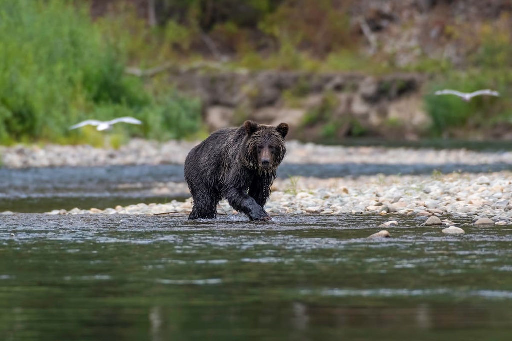
Part of the value of the Kitlope River comes from its undisturbed fish spawning sites. Here, you can find all five species of Pacific salmon as well as herring and oolichan (eulachon/candlefish). The lively creeks and rivers in the conservancy attract grizzly and black bears, as well as bald eagles who seasonally feast on the spawning fish.
The ancient forests of the conservancy are filled with old-growth Sitka spruce, Douglas fir, western red cedar, and western hemlock. Further up the slopes of the mountains in the region, the forests are typically filled with amabilis fir, yellow cedar, and mountain hemlock.
The forests of the conservancy are home to a variety of wildlife, including moose, deer, and many bird species. Meanwhile, the estuary and river delta are home to the rare marbled murrelet and other waterfowl. Furthermore, the mountain peaks of the conservancy boast the perfect habitat for mountain goats, and the treeline zone is filled with the shrieks of the hoary marmot.
The land that is now called the Huchsduwachsdu Nuyem Jees Kitlope Heritage Conservancy is part of the traditional territory of the Haisla Nation. The conservancy has been long used for traditional practices, such as hunting and foraging, and is still used by the Haisla for cultural purposes.
The connection between the Haisla and the land is a deeply rooted part of their identity. The Haisla believe that they were given stewardship over the land. As a result, the pristine condition of the conservancy shows their dedication to preserving the land for future generations.
Historically, the Haisla Nation consisted of two bands: the Kitlope of the upper Princess Royal Channel and Gardner Canal and the Kitamaat of the Douglas and Devastation channels. The Haisla Nation also consists of eight matrilineal clans (Salmon, Raven, Frog, Wolf, Killer Whale, Crow, Beaver, and Eagle).
The Haisla population was devastated by the smallpox and influenza pandemics of the late nineteenth and early twentieth centuries. During this time, both the Frog and Wolf clans were completely wiped out. However, the Haisla Nation recovered and it remains strong to this day.
The remains of village sites and culturally significant landmarks in the conservancy are part of the Haisla’s cultural connection to the land. Furthermore, there are two grease trails that travel through the conservancy. These trails historically connected the Haisla to the interior of British Columbia and to the Heiltsuk who traditionally live to the south.
These grease trails were used as part of the trade in eulachon oil. Food, furs, fish, and other goods were also carried along these trails for trade with the First Nations in the interior part of what is now British Columbia.
In the early twentieth century, many Haisla worked in canneries and in the logging industry. Interestingly, some Sitka spruce were harvested from along the Kitlope for the manufacture of aircraft during World War I.
As timber harvesting and industrial activity increased in the surrounding areas throughout the twentieth century, many watersheds were logged near Huchsduwachsdu Nuyem Jees. Fortunately, the Kitlope River valley was still relatively untouched and pristine, prompting the Haisla people to take action to preserve the area.
One of the Haisla’s main goals at the time was to maintain a place where natural processes prevailed and where food sources remained unpolluted. During the 1990s, steps were taken to declare the importance of the region and its significance to the Haisla people.
The Huchsduwachsdu Nuyem Jees / Kitlope Heritage Conservancy was officially established in 1996. Through the efforts of the Haisla and their allies, the Kitlope remains the largest undeveloped coastal temperate rainforest on the west coast of North America.
There are many activities and opportunities for adventure in the remote Huchsduwachsdu Nuyem Jees / Kitlope Heritage Conservancy. Some of the main activities that you can enjoy in the conservancy include canoeing, fishing, hunting, swimming, and camping.
There are two campsites located along the shores of Kitlope Lake and another along the banks of Kitlope River. These campsites are available on a first-come, first-serve basis, and they make for an excellent base camp to support further travel into the conservancy.
Kitlope Lake and Tewa River are two beautiful places to paddle, and if you’re up for it, there are many lovely beaches and places for swimming in Kitlope Lake. Furthermore, with the appropriate fishing license, visitors can angle for trout, char, and salmon in the conservancy.
As there are no roads that lead to the conservancy, you’ll need to arrive by either boat or plane. There aren’t any official trails in the conservancy either; however, there are plenty of opportunities to follow the historic trails that traverse through the area. Needless to say, the vast wilderness and stunning rivers of the conservancy are certainly a wonder to behold.
The Huchsduwachsdu Nuyem Jees / Kitlope Heritage Conservancy is a remote wilderness area located in the western Coast Mountains of British Columbia. The conservancy is accessible only by boat or plane and there aren’t many major communities located directly around its borders.
However, there are a number of towns and cities situated relatively close to the conservancy that can serve as good starting points for travel into the area. With that in mind, here are some of the best places to stay before or after your trip to the Huchsduwachsdu Nuyem Jees / Kitlope Heritage Conservancy.
Bella Coola is the location of the regional offices for the Central Coast Regional District. It earned this honor after Ocean Falls became a ghost town when the local paper mill shut down. The community is named Bella Coola; however, this name also refers to the entire valley area that’s located at the end of Highway 20.
While the community is situated about 100 km (60 mi) to the south of Huchsduwachsdu Nuyem Jees / Kitlope Heritage Conservancy, it is one of the closest communities to the park. Some of the many activities that you can enjoy in and around Bella Coola include heli-skiing tours, wildlife tours, and tours of the Petroglyph Gallery.
Additionally, some popular natural attractions located around Bella Coola include Odegaard Falls, Clayton Falls, and Snootli Creek Regional Park.
First Nations have lived in the area around Kitimat for generations in small fishing villages; however, the current townsite was founded in the 1950s. The community was essentially established by Alcan, an aluminum producer that was invited to work on a hydroelectric project in the region to supply power to their aluminum smelting operations.
Located alongside tidal waters at the head of the Kitimat Arm of the Douglas Channel, the community of Kitimat is home to over 8,000 residents who benefit from the thoughtful city planning of Clarence Stein. Stein was the designer of the original townsite and he created a beautiful and functional town for the residents.
Thanks to the town’s access to the ocean and its lush forests, residents and visitors in Kitimat have many options for exciting outdoor adventures. There are many hidden gems located around Kitimat, including trails that lead up mountains, along creeks and rivers, through valleys, and next to the ocean, so there’s something for everybody to enjoy in the town.


